
This is intended to be a complete list of the properties and districts on the National Register of Historic Places in Fairfield County, Connecticut, United States. The locations of National Register properties and districts for which the latitude and longitude coordinates are included below, may be seen in an online map.

The Magnolia Mound Plantation House is a French Creole house constructed in 1791 near the Mississippi River in Baton Rouge, Louisiana. Many period documents refer to the plantation as Mount Magnolia. The house and several original outbuildings on the grounds of Magnolia Mound Plantation are examples of the vernacular architectural influences of early settlers from France and the West Indies. The complex is owned by the city of Baton Rouge and maintained by its Recreation Commission (BREC). It is located approximately one mile south of downtown.

Auburn is an antebellum mansion in Duncan Park in Natchez, Mississippi. It was designed and constructed by Levi Weeks in 1812, and was the first building to exhibit Greek Revival order in the town. Its prominent two-story Greek portico served as a model for the subsequent architectural development of local mansions. It was declared a National Historic Landmark in 1974 and a Mississippi Landmark in 1984.

This list is of the properties and historic districts which are designated on the National Register of Historic Places or that were formerly so designated, in Hennepin County, Minnesota; there are 175 entries as of August 2020. A significant number of these properties are a result of the establishment of Fort Snelling, the development of water power at Saint Anthony Falls, and the thriving city of Minneapolis that developed around the falls. Many historic sites outside the Minneapolis city limits are associated with pioneers who established missions, farms, and schools in areas that are now suburbs in that metropolitan area.

This is a complete list of National Register of Historic Places listings in Ramsey County, Minnesota. It is intended to be a complete list of the properties and districts on the National Register of Historic Places in Ramsey County, Minnesota, United States. The locations of National Register properties and districts for which the latitude and longitude coordinates are included below, may be seen in an online map.

List of the National Register of Historic Places listings in Mercer County, New Jersey

This is a list of the National Register of Historic Places listings in Crow Wing County, Minnesota. It is intended to be a complete list of the properties and districts on the National Register of Historic Places in Crow Wing County, Minnesota, United States. The locations of National Register properties and districts for which the latitude and longitude coordinates are included below, may be seen in an online map.
This is a list of the National Register of Historic Places listings in Olmsted County, Minnesota. It is intended to be a complete list of the properties and districts on the National Register of Historic Places in Olmsted County, Minnesota, United States. The locations of National Register properties and districts for which the latitude and longitude coordinates are included below, may be seen in an online map.

This is a list of the National Register of Historic Places listings in Winona County, Minnesota. It is intended to be a complete list of the properties and districts on the National Register of Historic Places in Winona County, Minnesota, United States. The locations of National Register properties and districts for which the latitude and longitude coordinates are included below, may be seen in an online map.
This is a list of the National Register of Historic Places listings in Washington County, Minnesota. It is intended to be a complete list of the properties and districts on the National Register of Historic Places in Washington County, Minnesota, United States. The locations of National Register properties and districts for which the latitude and longitude coordinates are included below, may be seen in an online map.
This is a list of the National Register of Historic Places listings in Clay County, Minnesota. It is intended to be a complete list of the properties and districts on the National Register of Historic Places in Clay County, Minnesota, United States. The locations of National Register properties and districts for which the latitude and longitude coordinates are included below, may be seen in an online map.

This is a list of the National Register of Historic Places listings in Houston County, Minnesota. It is intended to be a complete list of the properties and districts on the National Register of Historic Places in Houston County, Minnesota, United States. The locations of National Register properties and districts for which the latitude and longitude coordinates are included below, may be seen in an online map.
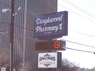
Dinglewood is a neighborhood/subdistrict located at the southern edge of Midtown Columbus, Georgia. In it is the tallest building in Columbus, the Aflac Tower. It is also home to the famous Dinglewood Pharmacy, which serves, in the opinions of the city's residents, the city's best scrambled hot dog. The boundaries of the neighborhood are generally acknowledged to be 17th Street to the north, Martin Luther King, Jr. Boulevard to the south, Interstate 185 to the east and Veterans Parkway to the west. In 2007, the estimated population of the area was 1,101.

This is a list of the National Register of Historic Places listings in Kandiyohi County, Minnesota. It is intended to be a complete list of the properties and districts on the National Register of Historic Places in Kandiyohi County, Minnesota, United States. The locations of National Register properties and districts for which the latitude and longitude coordinates are included below, may be seen in an online map.

Duncan Farm is an archaeological site located on a farmstead south of Illinois Route 100 in Jersey County, Illinois, near the city of Grafton. The site, which dates from the Woodland period, includes two burial mounds and a habitation site. The site was part of the Hopewell exchange system in Illinois and is the closest neighboring village site to the Golden Eagle regional transaction center, a major trade and social hub in the system. Archaeologists have suggested that the site is a local transaction center in the Golden Eagle site's region due to its two large mounds, which are roughly 200 feet (61 m) long and 100 feet (30 m) wide each. In addition, the site is archaeologically significant due to its distinctive stratification, which allows its artifacts to be easily dated.

The Duncan–Duitsman Farm Historic District is a nationally recognized agricultural historic district located northeast of George, Iowa, United States. It was listed on the National Register of Historic Places in 1994. At the time of its nomination it contained 19 resources, which included 12 contributing buildings, four contributing sites, one contributing structure, and two non-contributing buildings. Its historic importance is derived from being two pioneer farmsteads from the last section of Iowa opened to settlement.

The Duncan Rule House is a historic building located in Mason City, Iowa, United States. Rule was an attorney who hired E.R. Bogardus, a local builder to design and construct this house. The 2½-story frame structure features a large gable on the north and south elevations of the house. It is one of the few houses in the Shingle Style in Iowa that has an open gable like this. Other elements of the house include the semi-circular bay on the main floor with a somewhat asymmetrically placed veranda adjacent to it. There is also a Palladian window in the attic. The house was listed on the National Register of Historic Places in 1979.

John K. Dow (1861-1961) was an American architect. He designed the NRHP-listed Coolidge–Rising House, the NRHP-listed Grace Baptist Church, and the NRHP-listed Empire State Building. With Loren L. Rand, he designed the NRHP-listed Bump Block-Bellevue House-Hawthorne Hotel. With Clarence Z. Hubbell, he designed the NRHP-listed Hutton Building. They also designed Van Doren Hall and the Veterinary Science Building on the campus of Washington State University in Pullman, Washington.


