
Iritty is a Municipality and a Taluk of Kannur district in Kerala State, India. The town is the main market place for the farmer communities in the surrounding regions. Iritty is known as The Coorg Valley in God's Own Country. Iritty is at a distance of 20 km (12 mi) from Kannur International Airport and one among five taluks in Kannur district. Iritty is one of the major towns lies between Coorg and Kannur international airport -Mattanur.

Payyanur, is a municipal town and a taluk, a sub-district administrative unit, in the Kannur district of Kerala, India. On 10 March 2018, Kerala Chief Minister Pinarayi Vijayan inaugurated Payyanur as the fifth taluk in the district. Payyanur taluk comprises 22 villages including 16 de-linked from the Taliparamba taluk and six from the Kannur taluk. The town is situated on the banks of the Perumba River.
Kandankali is a village in Kerala, India. The village is situated about two kilometers south of the town of Payyanur in Kannur district.
Pariyaram is a Grama Panchayat consisting of two villages viz. Pariyaram census town and Kuttiyeri village. Pariyaram is a suburb of Taliparamba on National Highway between Taliparamba and Payyanur in Kerala state of India. Mini villages of Thiruvattoor, Koran Peedika, Mukkunnu & Chithappile Poyil are parts of Pariyaram.

Ulikkal is a growing town in Kannur District in Kerala. It is the HQ of Ulikkal Grama Panchayat in Iritty Taluk. Kerala State Hill highway SH 59 passes through Ulikkal Town.

Pulpally is a mid-sized town in Wayanad District of Kerala, India.Pulpally also known as 'The land of black gold'. Pulpally is also famous for its pure wild Wayanad honey. The only Seetha devi temple in Kerala is situated on Pulpally. Geographically a small town in Sultan Bathery Taluk and a "Grama Panchayath" under the local self governance system. It is about 24 km from Sultan Bathery, and is almost surrounded by forest. The main source of income is agriculture.

Naduvil is a small town in Kannur district in the Indian State of Kerala. The town is the headquarters of Naduvil Grama panchayat.

Pulingome is a village in Kannur District of Kerala state, India.
Ayyankunnu is a village in Kannur district in the Indian state of Kerala.The name ayyankunnu came from the five hills "Anchu Kunnu".

Cherukunnu is a census town in Kannur district in the Indian state of Kerala. Cherukunnu town is located on Valapattanam-Pappinisseri-Pazhayangadi main road, situated to the south of the Pazhayangadi in Kannur District in Kerala.

Ramanthali is a village in Kannur district in the Indian state of Kerala. It boasts the gateway for Indian Naval Academy in Ezhiamala.

Thirumeni is a village in Kannur district in the Kerala state of India. It is known for its hill station Chathamangalam Hills. The village has several recently migrated families from various parts of the erstwhile political entity (state) of Travancore who settled here in the famed "Malabar migration period" in the nineteenth century. Most of the inhabitants of the village reside in the valley of three major hills by name Chathamangalam Theruvamala alias Alumbumala, Kottathalachimala and Thevarkunnumala. Thirumeni is a small junction with a few government institutions, religious institutions and small shops in int. and is subdivided into smaller villages like Kokkadave, Prapoyil, Chathamangalam (Kannur), Thabore, Muthuvom, Korali, Chattivayal, Thannichal, Paruthikallu etc.

Thirunelly is a village in Wayanad district in the state of Kerala, India.
There are places of worship considered important in the Kannur district. Kannur District is one of the 14 districts in the state of Kerala, India. The town of Kannur is the district headquarters, and gives the district its name.

Pilathara is a suburb town of Payyannur in the Kannur district of Kerala, India. This region is noted for its cultural, traditional and religious characteristics. The Government Medical College, Kannur aka Pariyaram Medical College is just 4 km away from Pilathara. Pazhayangadi and Mathamangalam are located south and north of Pilathara respectively. It comes under Payyanur taluk and Cheruthazham village. Kannur International Airport is the nearest airport of about 50 km away. The nearby railway station is at Pazhayangadi, just 8 km away from Pilathara town.

Olayambadi is a small village about 21 km from Payyanur town in the Kannur district of Kerala state, South India.
Chathamangalam (ചാത്തമംഗലം), also known as Chathamangalam Hills, Kannur Theruvamala or just Theruvamala, is a hill station village and trekking spot in Kannur district, Kerala, India alongside the Coorg border of the neighbouring Karnataka state, which consists of a vast plain of green grasslands that made it earn the nickname Evergreen Chathamangalam. It is located in the border of Cherupuzha, Alakode and Udayagiri Grama Panchayats.

Kayakkunnu is a village near Nadavayal, Mananthavady in the Wayanad District of Kerala, India. The village is part of the Panamaram Panchayath, and the assembly constituency is Mananthavady. It is an agricultural area and its main crops include rice, coffee, pepper, ginger, cardamom, vanilla, rubber, areca nut, and coconut. The nearest towns are Nadavayal and Panamaram. Kayakkunn is situated midway along the Mananthavady–Gudalur interstate road.
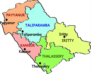
Payyanur Taluk comes under Taliparamba revenue division in Kannur district of Kerala, India. Payyanur is one of the 5 taluks in Kannur district established in March 2018 carved out from Taliparamba and Kannur taluks. Payyanur taluk comprises 22 villages including 16 delinked from Taliparamba taluk and 6 from Kannur taluk. It borders Kasaragod district in the north, Taliparamba and Kannur taluk in the south and Karnataka state in the east. Most of the government offices are in Payyanur Mini Civil Station. Payyanur taluk consists of Payyanur Municipality and 11 Panchayats.