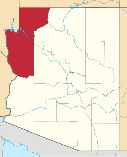
Kaibab, Arizona | |
---|---|
Location in Mohave County and the state of Arizona | |
Coordinates: 36°54′46″N112°40′7″W / 36.91278°N 112.66861°W | |
Country | United States |
State | Arizona |
County | Mohave |
Area | |
• Total | 6.46 sq mi (16.74 km2) |
• Land | 6.46 sq mi (16.72 km2) |
• Water | 0.01 sq mi (0.02 km2) |
Elevation | 4,991 ft (1,521 m) |
Population | |
• Total | 140 |
• Density | 21.69/sq mi (8.37/km2) |
Time zone | UTC-7 (MST) |
ZIP code | 86022 |
Area code | 928 |
FIPS code | 04-36500 |
GNIS feature ID | 42814 |
Kaibab is an unincorporated community and census-designated place (CDP) in Mohave County, Arizona, United States. It is within the Kaibab Indian Reservation. The population of the CDP was 140 at the 2020 census. [2]
Kaibab is located in the northeast corner of Mohave County at 36°54′46″N112°40′7″W / 36.91278°N 112.66861°W (36.912680, -112.668732). [3] Arizona State Route 389 forms the southern edge of the CDP; the highway leads northeast 13 miles (21 km) to Fredonia and northwest 18 miles (29 km) to Colorado City. The townsite of Kaibab is 3 miles (5 km) north of AZ 389 on Pipe Spring Road.
Pipe Spring National Monument is in the southwest corner of the CDP, close to AZ 389. The CDP is bordered to the north by the CDP of Moccasin. According to the United States Census Bureau, the Kaibab CDP has a total area of 6.4 square miles (16.7 km2), of which 0.01 square miles (0.02 km2), or 0.1%, is water. [1]
The townsite is located at a section of the Vermilion Cliffs and a southeast stretch of the Moccasin Mountains.
Census | Pop. | Note | %± |
---|---|---|---|
2000 | 275 | — | |
2010 | 124 | −54.9% | |
2020 | 140 | 12.9% | |
U.S. Decennial Census [4] |
As of the census [5] of 2000, there were 275 people, 88 households, and 69 families living in the CDP. The population density was 1.5 inhabitants per square mile (0.58/km2). There were 116 housing units at an average density of 0.6 per square mile (0.23/km2). The racial makeup of the CDP was 40% White, 53% Native American, 4% from other races, and 4% from two or more races. 8% of the population were Hispanic or Latino of any race. (Note: percentages do not total 100% because of rounding.)
There were 88 households, out of which 53% had children under the age of 18 living with them, 44% were married couples living together, 28% had a female householder with no husband present, and 21% were non-families. 19% of all households were made up of individuals, and 2% had someone living alone who was 65 years of age or older. The average household size was 3.1 and the average family size was 3.5.
In the CDP, the age distribution of the population shows 44% under the age of 18, 9% from 18 to 24, 23% from 25 to 44, 20% from 45 to 64, and 4% who were 65 years of age or older. The median age was 22 years. For every 100 females, there were 75.2 males. For every 100 females age 18 and over, there were 81.2 males.
The median income for a household in the CDP was $21,458, and the median income for a family was $22,679. Males had a median income of $25,313 versus $16,607 for females. The per capita income for the CDP was $9,421. About 27% of families and 30% of the population were below the poverty line, including 35% of those under the age of eighteen and none of those 65 or over.
The CDP is in the Fredonia-Moccasin Unified School District. [6]
Coconino County is a county in the North-Central part of the U.S. state of Arizona. Its population was 145,101 at the 2020 census. The county seat is Flagstaff. The county takes its name from Cohonino, a name applied to the Havasupai people. It is the second-largest county by area in the contiguous United States, behind San Bernardino County, California. It has 18,661 sq mi (48,300 km2), or 16.4% of Arizona's total area, and is larger than the nine smallest states in the U.S.
Mohave County is a county in the northwestern corner of the U.S. state of Arizona. As of the 2020 census, its population was 213,267. The county seat is Kingman, and the largest city is Lake Havasu City. It is the fifth largest county in the United States.
Fredonia is a town in Coconino County, Arizona, United States. As of the 2010 census it had a population of 1,314. Fredonia is the gateway to the North Rim of the Grand Canyon.
Grand Canyon Village is a census-designated place (CDP) located on the South Rim of the Grand Canyon, in Coconino County, Arizona, United States. Its population was 2,004 at the 2010 Census. Located in Grand Canyon National Park, it is wholly focused on accommodating tourists visiting the canyon. Its origins trace back to the railroad completed from Williams, to the canyon's South Rim by the Santa Fe Railroad in 1901. Many of the structures in use today date from that period. The village contains numerous landmark buildings, and its historic core is a National Historic Landmark District, designated for its outstanding implementation of town design.
Tusayan is a town located in Coconino County, Arizona, United States. It was incorporated in 2010. A resort town near the south entrance to Grand Canyon National Park. The population was 558 at the 2010 census.
Parker Strip is a census-designated place (CDP) in La Paz County, Arizona, United States. The population was 662 at the 2010 census.
Arizona Village is a census-designated place (CDP) on the Fort Mojave Indian Reservation in Mohave County, Arizona, United States. The population was 1,057 at the 2020 census, up from 946 in 2010 and 351 in 2000.
Desert Hills is an unincorporated community and census-designated place (CDP) in Mohave County, Arizona, United States. The population was 2,764 at the 2020 census, up from 2,245 at the 2010 census.
Mesquite Creek is an unincorporated community and census-designated place (CDP) in Mohave County, Arizona, United States. The population was 403 at the 2020 census.
Mohave Valley is an unincorporated community and census-designated place (CDP) in Mohave County, Arizona, United States. The population was 2,693 at the 2020 census. It is geographically connected to Needles, California, Fort Mohave and Bullhead City.
Mojave Ranch Estates is an unincorporated community and census-designated place (CDP) in Mohave County, Arizona, United States. The population was 53 as of the 2020 census.
New Kingman-Butler is an unincorporated community and census-designated place (CDP) in Mohave County, Arizona, United States, directly north of and bordering the city of Kingman. The population was 12,907 as of the 2020 census.
Peach Springs is a census-designated place (CDP) in Mohave County, Arizona, United States. The population was 1,098 at the 2020 census. Peach Springs serves as the administrative headquarters of the Hualapai people and is located on the Hualapai Reservation.
Willow Valley is an unincorporated community and census-designated place (CDP) in Mohave County, Arizona, United States. The population was 1,059 as of the 2020 census.
Pisinemo is a census-designated place (CDP) in Pima County, Arizona, United States. The population was 340 as of the 2020 census.
The Kaibab Indian Reservation is the home of the Kaibab Band of Paiute Indians, a federally recognized tribe of Southern Paiutes. The Indian reservation is located in northern part of the U.S. state of Arizona. It covers a land area of 188.75 square miles (488.9 km2) in northeastern Mohave County and northwestern Coconino County adjacent to the southern Utah border. The Pipe Spring National Monument lies in the southwestern section of the reservation. The Thunder Mountain Pootseev Dark-sky preserve is colocated with the reservation.
Centennial Park is an unincorporated community and census-designated place (CDP) in Mohave County, Arizona, United States. The population was 1,578 at the 2020 census, up from 1,264 at the 2010 census. It is the central location for the Centennial Park group, a fundamentalist Mormon group.
Moccasin is an unincorporated community and census-designated place in Mohave County, Arizona, United States. It is within the Kaibab Indian Reservation, and its population was 53 as of the 2020 census, down from 89 at the 2010 census. It is bordered to the south by the CDP of Kaibab.
Cane Beds is an unincorporated community and census-designated place (CDP) in Mohave County, Arizona, United States. It lies 4 miles (6 km) south of the border with Utah in the Arizona Strip, and is supported by services in Utah as well as some in Nevada.
Pinion Pines is an unincorporated community and census-designated place (CDP) in Mohave County, Arizona, United States. The population was 158 at the 2020 census.