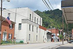
Keystone, West Virginia

Last updated

Keystone, West Virginia
Keystone, 52 north from gas station.jpg
U.S. Route 52 in the city's southwest
McDowell County West Virginia Incorporated and Unincorporated areas Keystone Highlighted.svg
Location of Keystone in McDowell County, West Virginia.
Coordinates: 37°24′54″N81°26′46″W / 37.41500°N 81.44611°W / 37.41500; -81.44611
Country United States
State West Virginia
County McDowell
Government
   Mayor Dennis Robertson
Area
[1]
  Total0.32 sq mi (0.84 km2)
  Land0.32 sq mi (0.84 km2)
  Water0.00 sq mi (0.00 km2)
Elevation
1,631 ft (497 m)
Population
 (2010) [2]
  Total282
  Estimate 
(2019) [3]
223
  Density688.27/sq mi (265.98/km2)
Time zone UTC-5 (Eastern (EST))
  Summer (DST) UTC-4 (EDT)
ZIP code
24852
Area code 304
FIPS code 54-43516
GNIS feature ID1554871 [4]
Website https://local.wv.gov/keystone/Pages/default.aspx

Keystone is a city in McDowell County, West Virginia, United States. Per the 2020 census, the population was 176. [5] Keystone is one of the few municipalities in West Virginia with an African-American majority, with 65 percent of the residents being black.

Contents

The term "Free State of McDowell" was coined by Matthew Thomas Whittico, a local newspaper editor and community leader from Keystone in the early 20th century. [6] Keystone possessed a unique combination of political, social, and economic characteristics that made it an attractive place for African-Americans to migrate to in the late 1800s and early 1900s. [6]

History

Keystone was founded in 1892 by the Keystone Coal & Coke Company. Keystone was then incorporated in 1909 by the Circuit Court of McDowell County. Its name is derived from the name of the coal and coke company operating at that point. [7] The city was formerly known as Cassville.

On May 1, 1895, 15,000 union miners (predominantly black) assembled in Keystone and armed themselves, planning to march across the state line to Virginia in order to force the Virginia miners in one bordering mine (also predominantly black) to unionize. The governor of Virginia, Charles O'Ferrall, ordered an artillery company and six infantry companies to the Virginia border, but West Virginia Governor William MacCorkle refused repeated requests from O'Ferrall to reciprocate.

This was in response to the N&W Railroad lowering the minimum price guarantee on coal shipped to Tidewater ports. The operators reduced wages by 20% in response and encouraged their miners to strike. By the end of April that year, the mines on the WV side had completely shut down, but a large mine across the state line in Virginia continued to operate.

The strike collapsed by the end of August. The UMWA was a relatively young union, and could not support a strike of this magnitude. In the end, most of the mines resumed operations with mostly imported strikebreakers. [8]

Geography

According to the United States Census Bureau, the city has a total area of 0.32 square miles (0.83 km2), all land. [9]

The town is a railway station on the Norfolk Southern Railway (former Norfolk and Western) network.

Demographics

Historical population
CensusPop.Note
1900 1,088
1910 2,04788.1%
1920 1,839−10.2%
1930 1,8973.2%
1940 2,94255.1%
1950 2,594−11.8%
1960 1,457−43.8%
1970 1,008−30.8%
1980 902−10.5%
1990 627−30.5%
2000 453−27.8%
2010 282−37.7%
2020 176−37.6%
U.S. Decennial Census [10]
2015 Estimate [11]

2020 census

Keystone city, West Virginia – Racial and ethnic composition
Note: the US Census treats Hispanic/Latino as an ethnic category. This table excludes Latinos from the racial categories and assigns them to a separate category. Hispanics/Latinos may be of any race.
Race / Ethnicity (NH = Non-Hispanic)Pop 2010 [12] Pop 2020 [13] % 2010% 2020
White alone (NH)966234.04%35.23%
Black or African American alone (NH)18310164.89%57.39%
Native American or Alaska Native alone (NH)000.00%0.00%
Asian alone (NH)110.35%0.57%
Pacific Islander alone (NH)000.00%0.00%
Some Other Race alone (NH)010.00%0.57%
Mixed Race or Multi-Racial (NH)0100.00%5.68%
Hispanic or Latino (any race)210.71%0.57%
Total282176100.00%100.00%

2010 census

As of the census [2] of 2010, there were 282 people, 122 households, and 74 families living in the city. The population density was 881.3 inhabitants per square mile (340.3/km2). There were 183 housing units at an average density of 571.9 per square mile (220.8/km2). The racial makeup of the city was 34.4% White, 65.2% African American, and 0.4% Asian. Hispanic or Latino of any race were 0.7% of the population.

There were 122 households, of which 32.8% had children under the age of 18 living with them, 28.7% were married couples living together, 25.4% had a female householder with no husband present, 6.6% had a male householder with no wife present, and 39.3% were non-families. 36.1% of all households were made up of individuals, and 13.1% had someone living alone who was 65 years of age or older. The average household size was 2.31 and the average family size was 2.95.

The median age in the city was 38 years. 23.4% of residents were under the age of 18; 9.3% were between the ages of 18 and 24; 23% were from 25 to 44; 31.9% were from 45 to 64; and 12.4% were 65 years of age or older. The gender makeup of the city was 41.5% male and 58.5% female.

2000 census

As of the census of 2000, there were 453 people, 203 households, and 120 families living in the city. The population density was 1,397.1 people per square mile (546.6/km2). There were 236 housing units at an average density of 727.8 per square mile (284.8/km2). The racial makeup of the city was 72.85% African American, 24.50% White, 0.44% Native American, 0.22% from other races, and 1.99% from two or more races. Hispanic or Latino of any race were 0.22% of the population.

There were 203 households, out of which 27.1% had children under the age of 18 living with them, 25.6% were married couples living together, 29.6% had a female householder with no husband present, and 40.4% were non-families. 38.9% of all households were made up of individuals, and 19.7% had someone living alone who was 65 years of age or older. The average household size was 2.23 and the average family size was 2.93.

In the city the population was spread out, with 27.2% under the age of 18, 7.7% from 18 to 24, 21.4% from 25 to 44, 21.6% from 45 to 64, and 22.1% who were 65 years of age or older. The median age was 40 years. For every 100 females, there were 70.3 males. For every 100 females age 18 and over, there were 68.4 males.

The median income for a household in the city was $10,417, and the median income for a family was $12,639. Males had a median income of $14,167 versus $18,750 for females. The per capita income for the city was $7,033, the second lowest in the state. About 48.8% of families and 46.3% of the population were below the poverty line, including 63.8% of those under age 18 and 25.5% of those age 65 or over.

See also

Related Research Articles

<span class="mw-page-title-main">McDowell County, West Virginia</span> County in West Virginia, United States

McDowell County is a county in the U.S. state of West Virginia. As of the 2020 census, the population was 19,111. Its county seat is Welch. McDowell County is the southernmost county in the state. It was created in 1858 by the Virginia General Assembly and named for Virginia Governor James McDowell. It became a part of West Virginia in 1863, when several Union-affiliated counties seceded from the state of Virginia during the American Civil War. McDowell County is located in the Cumberland Mountains, part of the Appalachia region.

<span class="mw-page-title-main">Whitesville, West Virginia</span> Town in West Virginia, United States

Whitesville is a town and former coal town in Boone County, West Virginia, United States, along the Big Coal River. The population was 361 at the 2020 census. Whitesville was incorporated on August 15, 1935, by the Boone County Circuit Court. The town derives its name from B. W. White, a pioneer settler. Whitesville was formerly known as Jarrold's Valley and Pritchard City.

<span class="mw-page-title-main">Mount Hope, West Virginia</span> City in West Virginia, United States

Mount Hope is a city in Fayette County, West Virginia, United States. The population was 1,414 at the 2010 census.

<span class="mw-page-title-main">Bayard, West Virginia</span> Town in West Virginia, United States

Bayard is a town in Grant County, West Virginia, United States. The population was 200 at the 2020 census. Bayard was incorporated in 1893 and named in honor of Thomas F. Bayard, Jr., who later became a United States senator from Delaware (1923–1929). Bayard was founded on the West Virginia Central and Pittsburgh Railroad as a coal mining community. Coal mining has remained the town's chief industry.

<span class="mw-page-title-main">Marmet, West Virginia</span> Town in West Virginia, United States

Marmet is a town in Kanawha County, West Virginia, United States, along the Kanawha River. The population was 1,501 at the 2020 census.

<span class="mw-page-title-main">Pratt, West Virginia</span> Town in West Virginia, United States

Pratt is a town in Kanawha County, West Virginia, United States, along the Kanawha River. The population was 482 at the 2020 census.

<span class="mw-page-title-main">Henderson, West Virginia</span> Unincorporated Town in West Virginia, United States

Henderson is an unincorporated community and former town in Mason County, West Virginia, United States, at the confluence of the Ohio and Kanawha Rivers. The population was 231 at the 2020 census. It is part of the Point Pleasant, WV–OH Micropolitan Statistical Area. The town was incorporated in 1893 and named for Samuel Bruce Henderson, who owned the townsite at the time. The town was unincorporated following a public hearing on August 11, 2022.

<span class="mw-page-title-main">Gary, West Virginia</span> City in West Virginia, United States

Gary is a city located along the Tug Fork River in McDowell County, West Virginia, United States. According to the 2020 census, the city had a population of 762. It was named for Elbert Henry Gary, one of the founders of U.S. Steel. The former coal towns of Elbert, Filbert, Thorpe, and Wilcoe became part of Gary at the time of its incorporation in 1971.

<span class="mw-page-title-main">Kimball, West Virginia</span> Town in West Virginia, United States

Kimball is a town in McDowell County, West Virginia, United States. Per the 2020 census, the population was 145.

<span class="mw-page-title-main">War, West Virginia</span> City in West Virginia, United States

War is a city in McDowell County, West Virginia, United States. The population was 690 at the 2020 census. War was incorporated in 1920 by the Circuit Court of McDowell County. Its name is derived from War Creek, whose confluence with Dry Fork is located within the city. War is the only place in the United States with this name. War was formerly known as Miner's City.

<span class="mw-page-title-main">Welch, West Virginia</span> City in West Virginia, United States

Welch is a city in and the county seat of McDowell County, West Virginia, United States. The population was 3,590 at the 2020 census; the 2021 census estimate put the population at 1,914, due to the Federal Correctional Institution, McDowell leaving city limits. Welch was incorporated as a city in 1893.

<span class="mw-page-title-main">Bramwell, West Virginia</span> Town in West Virginia, United States

Bramwell is a town in Mercer County, West Virginia, United States, along the Bluestone River. The population was 277 at the 2020 census. It is part of the Bluefield, WV-VA micropolitan area which has a population of 107,578.

<span class="mw-page-title-main">Matewan, West Virginia</span> Town in West Virginia, United States

Matewan is a town in Mingo County, West Virginia, United States at the confluence of the Tug Fork River and Mate Creek. The population was 412 at the 2020 census, down from 499 in 2010. The Norfolk Southern Railway's Pocahontas District passes through the town. It was a key site of the Coal Wars and the location of the Battle of Matewan in 1920.

<span class="mw-page-title-main">Williamson, West Virginia</span> City in West Virginia, United States

Williamson is a city in Mingo County, West Virginia, United States, situated along the Tug Fork River. The population was 3,042 at the 2020 census. It is the county seat of Mingo County, and is the county's largest and most populous city. Williamson is home to Southern West Virginia Community and Technical College. The Tug Fork River separates Williamson from South Williamson, Kentucky.

<span class="mw-page-title-main">Coal City, West Virginia</span> Census-designated place in West Virginia, United States

Coal City is a census-designated place (CDP) in Raleigh County, West Virginia, United States. The population was 1,815 at the 2010 census. Coal City's population is composed of other surrounding unincorporated communities.

<span class="mw-page-title-main">Mabscott, West Virginia</span> Town in West Virginia, United States

Mabscott is a town in Raleigh County, West Virginia, United States. The population was 1,333 at the 2020 census. The town's name is a contraction of the name Mabel Scott, wife of local coal operator Cyrus H. Scott.

<span class="mw-page-title-main">Stanaford, West Virginia</span> Census-designated place in West Virginia, United States

Stanaford is a census-designated place (CDP) and coal town in Raleigh County, West Virginia, United States. The population was 1,350 at the 2010 census.

<span class="mw-page-title-main">Hinton, West Virginia</span> City in West Virginia, United States

Hinton is a city in and the county seat of Summers County, West Virginia, United States. The population was 2,266 at the 2020 census. Hinton was established in 1873 and chartered in 1897. Hinton was named after John "Jack" Hinton, the original owner of the town site. Much of Hinton's downtown was placed on the National Register of Historic Places in 1984. In 1994, part of Paramount's film Lassie was shot in Hinton. In the 1990s, Hinton's downtown experienced economic decline after a hospital moved away and Interstate 64 bypassed the town. In 2007, Hinton native and business owner Ken Allman founded MountainPlex Properties, which since then has worked to preserve and revitalize the Hinton Historic District.

<span class="mw-page-title-main">Thomas, West Virginia</span> City in West Virginia, United States

Thomas is a city and former coal town in Tucker County, West Virginia, United States. The population was 623 at the 2020 census.

<span class="mw-page-title-main">Hundred, West Virginia</span> Town in West Virginia, United States

Hundred is a town in Wetzel County, West Virginia, United States. The population was 257 at the 2020 census. It was named for the fact that local resident Henry "Old Hundred" Church was a centenarian. Hundred is the only place in the United States with this name.

References

  1. "2019 U.S. Gazetteer Files". United States Census Bureau. Retrieved August 7, 2020.
  2. 1 2 "U.S. Census website". United States Census Bureau . Retrieved January 24, 2013.
  3. "US Board on Geographic Names". United States Geological Survey. October 25, 2007. Retrieved January 31, 2008.
  4. "Keystone city, West Virginia". United States Census Bureau . Retrieved April 15, 2022.
  5. 1 2 Deaner, Larry Scott (2004). Home in the McDowell County Coalfields: The African-American Population of Keystone, West Virginia (M.A., Geography thesis). Ohio University.
  6. Kenny, Hamill (1945). West Virginia Place Names: Their Origin and Meaning, Including the Nomenclature of the Streams and Mountains. Piedmont, WV: The Place Name Press. p. 350.
  7. Black Coal Miners in America: Race, Class, and Community Conflict 1780-1980, Ronald L. Lewis p137-138
  8. "US Gazetteer files 2010". United States Census Bureau. Archived from the original on January 25, 2012. Retrieved January 24, 2013.
  9. "U.S. Decennial Census". Census.gov. Retrieved June 11, 2013.
  10. "Population Estimates". United States Census Bureau. Archived from the original on June 22, 2016. Retrieved May 23, 2016.
  11. "P2 Hispanic or Latino, and Not Hispanic or Latino by Race – 2010: DEC Redistricting Data (PL 94-171) – Keystone city, West Virginia". United States Census Bureau .
  12. "P2 Hispanic or Latino, and Not Hispanic or Latino by Race – 2020: DEC Redistricting Data (PL 94-171) – Keystone city, West Virginia". United States Census Bureau .