
Kinrossie is a linear village in the Perth and Kinross area of Scotland. [1] It is less than a mile south off the A94 road, 8 miles (13 kilometres) from Perth and 6 miles (10 kilometres) from Coupar Angus.
Kinrossie is a linear village in the Perth and Kinross area of Scotland. [1] It is less than a mile south off the A94 road, 8 miles (13 kilometres) from Perth and 6 miles (10 kilometres) from Coupar Angus.

The M90 is a motorway in Scotland. It runs from Junction 1A of the M9 motorway, south of the Queensferry Crossing, to Perth. It is the northernmost motorway in the United Kingdom. The northern point goes to the western suburbs of Perth at Broxden. A small part of the M90 was originally numbered as the M85 motorway.
The Battle of Methven took place at Methven, Scotland on 19 June 1306, during the Wars of Scottish Independence. The battlefield was researched to be included in the Inventory of Historic Battlefields in Scotland and protected by Historic Scotland under the Scottish Historical Environment Policy of 2009, but was excluded due to the uncertainty of its location.

Aberfeldy is a burgh in Perth and Kinross, Scotland, on the River Tay. A small market town, Aberfeldy is located in Highland Perthshire. It was mentioned by Robert Burns in the poem The Birks Of Aberfeldy.
Strathallan is the strath of the Allan Water in Scotland. The strath stretches north and north-east from Stirling through Bridge of Allan, Dunblane and Blackford to Auchterarder in Perth and Kinross.

A mercat cross is the Scots name for the market cross found frequently in Scottish cities, towns and villages where historically the right to hold a regular market or fair was granted by the monarch, a bishop or a baron. It therefore served a secular purpose as a symbol of authority, and was an indication of a burgh's relative prosperity. Historically, the term dates from the period before 1707, when the Kingdom of Scotland was an independent state, but it has been applied loosely to later structures built in the traditional architectural style of crosses or structures fulfilling the function of marking a settlement's focal point. Historical documents often refer simply to "the cross" of whichever town or village is mentioned. Today, there are around 126 known examples of extant crosses in Scotland, though the number rises if later imitations are added.

Glen Lyon is a glen in the Perth and Kinross region of Scotland. It is the longest enclosed glen in Scotland and runs for 34 miles from Loch Lyon in the west to the village of Fortingall in the east.
The A912 is a major road in both Perth and Kinross and Fife, Scotland. It runs from the A9 in Perth, in the north, to the A92 at Muirhead, in the south. Part of it was formerly part of the A90.

Meikleour is a village in Perth and Kinross, Scotland. It lies near the confluence of the Tay and the Isla in the valley of Strathmore, 12 miles north of Perth and 4 miles south of Blairgowrie. It is in the parish of Caputh.
Gowrie is a region in central Scotland and one of the original provinces of the Kingdom of Alba. It covered the eastern part of what became Perthshire. It was located to the immediate east of Atholl, and originally included the area around Perth, though that was later detached as Perthia.
Ballechin distillery was a Scotch whisky distillery operated between 1810 and 1927 and was one of seven original farm distilleries operating in Perthshire. Out of these seven, Edradour is the only one remaining.
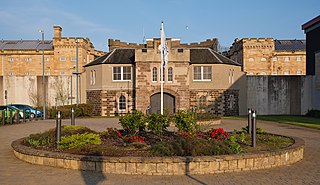
HM Prison Perth is a prison that houses short term adult male prisoners. A maximum security establishment which also houses fine defaulters and those on remand from the courts of Angus, City of Dundee, Perth and Kinross and the northern part of Fife. There is also a secure unit for Category A prisoners who are serving sentences of up to life imprisonment. It is Scotland's oldest prison still in use.
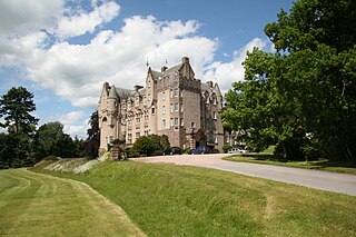
Kincardine Castle is a 19th-century manor house near Auchterarder in Perth and Kinross, Scotland. The building lies 1.5 kilometres (0.93 mi) south-west of the town, on the Ruthven Water. The Gothic house was constructed in 1801–1803, and is a category B listed building.

The Rob Roy Way is a Scottish long distance footpath that runs from Drymen in Stirling to Pitlochry in Perth and Kinross. The path was created in 2002, and takes its name from Rob Roy MacGregor, a Scottish folk hero and outlaw of the early 18th century. It traverses countryside that he knew and travelled frequently. The route crosses the Highland Boundary Fault, a geological fault where the Highlands meet the Lowlands. Views from the trail overlook Loch Lubnaig, Loch Earn, Loch Venachar and Loch Tay. The way is 127 kilometres (79 mi) in length if the direct route along the southern shore of Loch Tay and the River Tay is followed between Ardtalnaig and Aberfeldy. An optional loop also links these places via Amulree: choosing this option increases the length by a further 27 kilometres (17 mi) to 154 kilometres (96 mi).

The River Almond is a tributary of the River Tay in Perth and Kinross, Scotland. It rises in the hills to the south-east of Loch Tay, and flows eastwards through Glenalmond. It runs through the village of Almondbank, before joining the Tay immediately north of Perth. The river's course is around 48 kilometres (30 mi) long

Murthly is a village in Perth and Kinross, Scotland. It lies on the south bank of the River Tay, 5 miles southeast of Dunkeld, and 9+1⁄2 miles north of Perth. Perth District Asylum, later known as Murthly Hospital, was opened in the village on 1 April 1864 for 'pauper lunatics'. It was the second district asylum to be built in Scotland under the terms of the 1857 Lunacy (Scotland) Act. It closed in 1984 and was later demolished. The village has a stone circle, in the former grounds of the hospital. The village formerly had a railway station on the Perth and Dunkeld Railway, which closed in 1965.

The River Garry is a major tributary of the River Tummel, itself a tributary of the River Tay, in the traditional county of Perthshire in the Scottish Highlands. It emerges from the northeastern end of Loch Garry (56.8193°N 4.2311°W), just to the southeast of the Pass of Drumochter, and flows southeastwards and eastwards down Glen Garry to the narrow Pass of Killiecrankie beyond which it joins the Tummel (56.7182°N 3.7790°W).

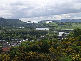
Collace is a parish in Perthshire, Scotland, 8 miles northeast of Perth, in the Carse of Gowrie district. The parish boundary includes the neighbouring villages of Kinrossie and Saucher.

Moulin is a village in Perthshire in central Scotland. It lies in the Tummel valley, 1 kilometre (0.62 mi) north of Pitlochry, and 40 kilometres (25 mi) north of Perth.

Fowlis Wester is a small village in Perth and Kinross, Scotland. It is around 6 kilometres (3.7 mi) east of Crieff and 19 kilometres (12 mi) west of Perth. The parish of Fowlis Wester includes the Abercairny estate to the south-west.
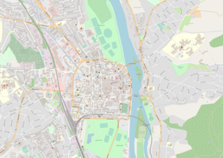
The A989 is a road in Perth, Scotland. Also known as the Perth Inner Ring Road, due to its circumnavigation of the city centre, it is 1.93 miles (3.11 km) long. Perth's city centre is around 0.5 miles (0.80 km) long and wide. The road was constructed around 1985.
Coordinates: 56°28′33″N3°19′11″W / 56.47579°N 3.31980°W
| | This Perth and Kinross location article is a stub. You can help Wikipedia by expanding it. |