Kinross is a burgh in Perth and Kinross, Scotland, around 13 miles south of Perth and around 20 miles northwest of Edinburgh. It is the traditional county town of the historic county of Kinross-shire.

Abernethy is a village and former burgh in the Perth and Kinross council area and historic county of Perthshire, in the east central Lowlands of Scotland. The village is situated in rural Strathearn, 8 miles (13 km) south-east of the city of Perth, near the River Earn's confluence with the River Tay and on the northern edge of the Ochil Hills.

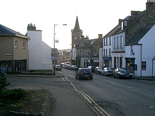
Alyth is a town in Perth and Kinross, Scotland, five miles northeast of Blairgowrie and about 17 miles northwest of Dundee. In 2016 the town had an estimated population of 2,400.

William Low & Co plc, popularly referred to as Willie Low's and latterly marketed as Wm Low, was a chain of supermarkets headquartered in Dundee, Scotland. Initially founded in 1868, Low's had branches throughout Scotland, North East England, Cumbria and Yorkshire. As a group, it was smaller than most of its competitors and often served small towns, although it still had several large hypermarkets. Low's use to trade on their Scottishness as a unique selling point in Scotland. At one stage, the company also ran a chain of frozen food stores known as Lowfreeze. Lowfreeze was sold in 1987 to Bejam.

Errol is a village in Perth and Kinross, Scotland, about halfway between Dundee and Perth. It is one of the principal settlements of the Carse of Gowrie. It lies just north of the River Tay. The 2016 population of Errol was estimated to be 1,500 persons, compared to 1,070 in the 2001 Census and 1,311 in the 2011 Census.

Ladybank is a village and former burgh of Fife, Scotland. It is about 62 kilometres (39 mi) north of Edinburgh, 8 kilometres (5.0 mi) southwest of Cupar, close to the River Eden. Its 2006 population was estimated at 1,582.

William Edward Baxter was a Scottish businessman, Liberal politician and travel writer.

The Dundee and Newtyle Railway opened in 1831 and was the first railway in the north of Scotland. It was built to carry goods between Dundee and the fertile area known as Strathmore; this involved crossing the Sidlaw Hills, and was accomplished with three rope-worked inclined planes. Newtyle was simply a remote railhead, and the anticipated traffic volumes were not achieved, the inclines incurred heavy operating costs, and the railway never made money.

Meigle is a village in Strathmore, Scotland. It lies in the council area of Perth and Kinross in the Coupar Angus and Meigle ward. It lies on the A94 road between Perth and Forfar.The A94 used to be the main route between Aberdeen and Perth. Other smaller settlements nearby are Balkeerie, Kirkinch and Kinloch. Meigle is accessed from the north and south via the B954 road. In 1971 it had a population of 357.
Luncarty is a village in Perth and Kinross, Scotland, approximately 4 miles north of Perth. It lies between the A9 to the west, and the River Tay to the east.

Ardler railway station served the village of Ardler in the Scottish county of Perth and Kinross. Its proximity to Alyth Junction made it part of the divergence of the Dundee and Newtyle Railway from the Scottish Midland Junction Railway running between Perth and Arbroath.

Greenloaning is a village in Perth and Kinross, Perthshire, Scotland. It lies by the Allan Water and the Stirling-Perth Railway line. It is 1 mile south of Braco and 5 miles north of Dunblane.

Sir David Baxter, 1st Baronet (1793–1872), was a linen manufacturer in Dundee, Scotland, and a baronet. He also performed a considerable amount of philanthropic work, benefiting his home city of Dundee and more widely Scottish education.
The Abertay Historical Society (AHS) is a historical society based in Dundee, Scotland. It aims to promote interest in history, with a special focus on the history of Perthshire, Angus and Fife. The AHS runs a regular programme of public lectures on historical topics and also organises special events. The Society also publishes books, usually producing at least one publication per year.
Mary Ann Baxter was a philanthropist in the Scottish city of Dundee.

Women's suffrage was the seeking of the right of women to vote in elections. It was carried out by both men and women, it was a very elongated and gruelling campaign that went on for 86 years before the Representation of the People Act 1918 was introduced on 6 February 1918, which provided a few women with the right to vote.

The timeline of Dundee history shows the significant events in the history of Dundee, Scotland.

Kinfauns is a village in Perth and Kinross, Scotland, at the western end of the Carse of Gowrie, 3 miles (4.8 km) east of Perth.

South Street is a prominent street in the Scottish city of Perth, Perth and Kinross. Established in at least the 15th century, it runs for about 0.5 miles (0.80 km), from the Dundee Road in the east to County Place in the west, passing through the entire breadth of the city. Queen's Bridge, completed in 1960 and opened by Queen Elizabeth II, carries South Street across the River Tay to and from Kinnoull.

