The Carse of Gowrie is a stretch of low-lying country in the southern part of Gowrie, Perth and Kinross, Scotland. It stretches for about 20 miles along the north shore of the Firth of Tay between Perth and Dundee. The area offers high-quality agricultural land and is well known as a major area for strawberry, raspberry and general fruit growing. Fruit is easy to cultivate in the area because of its southerly aspect and low rainfall. It has been suggested that monks brought new varieties of apples and pears to the area in the Middle Ages and there may have been vineyards growing on slopes near the River Tay.

Durweston is a village and civil parish in the English county of Dorset. It lies two miles northwest of the town of Blandford Forum. It is sited by the River Stour at the point where it flows out of the Blackmore Vale through a steep, narrow gap between the Dorset Downs and Cranborne Chase. In the 2011 census the parish had a population of 398.

Errol is a village in Perth and Kinross, Scotland about halfway between Dundee and Perth. It is one of the principal settlements of the Carse of Gowrie. It lies just north of the River Tay. The 2016 population of Errol was estimated to be 1,500 persons, compared to 1,070 in the 2001 Census.

Aberdalgie is a small village in the Scottish council area of Perth and Kinross. It is 3 miles southwest of Perth, and lies between the B9112 road, to the north, and the River Earn, to the south. Milltown Burn and Cotton Burn streams meet in the village centre, The village contains Aberdalgie Parish Church, the present building of which dates to 1773. The historic Dupplin Castle is 1+1⁄2 miles east of the village.

Aberuthven is a small village in Perth and Kinross, Scotland. It lies approximately 2+1⁄2 miles northeast of Auchterarder and 10 miles southwest of Perth at an elevation of 128 feet. It lies on the A824 road, formerly the A9, having been bypassed along with Auchterarder since 1983. The village is centred on the village hall, with a historic church just outside the village. The population has almost doubled in recent years.

Fingask Castle is a country house in Perth and Kinross, Scotland. It is perched 200 feet (61 m) above Rait, three miles (5 km) north-east of Errol, in the Braes of the Carse, on the fringes of the Sidlaw Hills. Thus it overlooks both the Carse of Gowrie and the Firth of Tay and beyond into the Kingdom of Fife. The name derives from Gaelic fionn-gasg: a white or light-coloured appendage.
Longforgan is a village and parish in the Carse of Gowrie, in Perth and Kinross, Scotland. It lies 5 miles west of Dundee on the main A90 road.
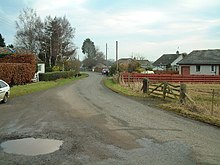
Cottown is a village in Perth and Kinross, Scotland, east of the village of St.Madoes and approximately 8 miles east of Perth. This area is in the Carse of Gowrie, and Cottown sits on a bank a rich alluvial soil to the north of the Firth of Tay between Perth and Dundee. It is the location of one of the largest concentrations of mudwall structures in Scotland, centred on the parish of Errol.

Hapton is a village and civil parish in the Borough of Burnley in Lancashire, England, 3 miles (4.8 km) west of Burnley, with a railway station on the East Lancashire Line. At the United Kingdom Census 2011, it had a population of 1,979.

Newton by Castle Acre is a village and civil parish in the Breckland district of the English county of Norfolk. It is situated on the A1065 Mildenhall to Fakenham road, about 4 miles (6.4 km) north of the town of Swaffham. The village is 28 miles (45 km) from the city of Norwich and 103 miles (166 km) from London.
Grandtully is a small village in Perthshire, Scotland.

Rait is a small village in Perth and Kinross, Scotland. It lies 2+1⁄2 miles northwest of Errol, in the Gowrie area west of Dundee, on a minor road crossing the Sidlaw Hills through the Glen of Rait. The village is mainly residential with stone cottages, some modern developments and also features some single storey thatched cottages dating back to the 1700s or early 1800s which form a fermtoun. The former parish church, now ruined, was built in the Middle Ages, and abandoned in the 17th century when the parish of Rait was merged with Kilspindie. The remains of a prehistoric promontory fort lie to the east of the village. The 16th-century Fingask Castle is located to the north of the village, on the south-facing slopes of the Sidlaw Hills.

Rhynd is a hamlet in Perth and Kinross, Scotland. It is located 3+1⁄4 miles southeast of Perth, on the south side of the River Tay.
Dowally is a village and parish in Perth and Kinross, Scotland. It lies 3+1⁄2 miles (5.6 km) north of Dunkeld on the A9 road.

Woodside is a small village in Scotland, 12 miles from Perth, in the Perth and Kinross council area. It is joined onto another village, Burrelton. It is 2 miles from Coupar Angus, the nearest town.

Caputh is a parish and village in Perth and Kinross, Scotland. It lies on the A984 Coupar Angus to Dunkeld road about 6 miles southeast of Dunkeld and 8 miles west of Coupar Angus.

Collace is a parish in Perthshire, Scotland, 8 miles northeast of Perth, in the Carse of Gowrie district. The parish boundary includes the neighbouring villages of Kinrossie and Saucher.

Killiechassie is a country estate and house near Weem, about one mile northeast of Aberfeldy, in Perth and Kinross, Scotland. The estate lies on the banks of the River Tay in some 12 acres, about 74 miles north of Edinburgh. It was owned by the Douglas family in the latter part of the 19th century, and a new house was erected in 1865. A dovecote by the house was listed as Grade B on 9 June 1981. The house was purchased by author J.K. Rowling in 2001.
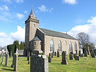
Errol Parish Church is a listed church in the Scottish village of Errol, Perth and Kinross. It has the informal names of North Church and the Cathedral of the Carse.