
Perth is a centrally located Scottish city, on the banks of the River Tay. It is the administrative centre of Perth and Kinross council area and is the historic county town of Perthshire. It had a population of about 47,430 in 2018.

Auchterarder is a town north of the Ochil Hills in Perth and Kinross, Scotland, and home to the Gleneagles Hotel. The 1+1⁄2-mile-long (2.5-kilometre) High Street of Auchterarder gave the town its popular name of "The Lang Toun" or Long Town.
Kinross is a burgh in Perth and Kinross, Scotland, around 13 miles south of Perth and around 20 miles northwest of Edinburgh. It is the traditional county town of the historic county of Kinross-shire.

Blairgowrie and Rattray is a twin burgh in Perth and Kinross, Scotland. Locals refer to the town as "Blair". Blairgowrie is the larger of the two former burghs which were united by an Act of Parliament in 1928 and lies on the southwest side of the River Ericht while Rattray is on the northeast side. Rattray claims to be the older and certainly Old Rattray, the area round Rattray Kirk, dates back to the 12th century. New Rattray, the area along the Boat Brae and Balmoral Road dates from 1777 when the River was spanned by the Brig o' Blair. The town lies on the north side of Strathmore at the foot of the Grampian Mountains. The west boundary is formed by the Knockie, a round grassy hill, and Craighall Gorge on the Ericht. Blairgowrie and Rattray developed over the centuries at the crossroads of several historic routes with links from the town to Perth, Coupar Angus, Alyth and Braemar. The roads to Coupar Angus and Braemar form part of General Wade's military road from Perth to Ayrshire then over the tiny bridge to the hill Fort George. The town's centrepiece is the Wellmeadow, a grassy triangle in the middle of town which hosts regular markets and outdoor entertainment.

Alyth is a town in Perth and Kinross, Scotland, five miles northeast of Blairgowrie and about 17 miles northwest of Dundee. In 2016 the town had an estimated population of 2,400.

Aberfeldy is a burgh in Perth and Kinross, Scotland, on the River Tay. A small market town, Aberfeldy is located in Highland Perthshire. It was mentioned by Robert Burns in the poem The Birks Of Aberfeldy and in the Ed Sheeran song The Hills of Aberfeldy.

Kenmore is a small village in Perthshire, in the Highlands of Scotland, located where Loch Tay drains into the River Tay.

Aberdalgie is a small village in the Scottish council area of Perth and Kinross. It is 3 miles southwest of Perth, and lies between the B9112 road, to the north, and the River Earn, to the south. Milltown Burn and Cotton Burn streams meet in the village centre, The village contains Aberdalgie Parish Church, the present building of which dates to 1773. The historic Dupplin Castle is 1+1⁄2 miles east of the village.
Abernyte is a small village in Perth and Kinross in Scotland.

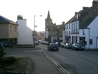
Aberuthven is a small village in Perth and Kinross, Scotland. It lies approximately 2+1⁄2 miles northeast of Auchterarder and 10 miles southwest of Perth at an elevation of 128 feet. It lies on the A824 road, formerly the A9, having been bypassed along with Auchterarder since 1983. The village is centred on the village hall, with a historic church just outside the village. The population has almost doubled in recent years.

Ladybank is a village and former burgh of Fife, Scotland. It is about 62 kilometres (39 mi) north of Edinburgh, 8 kilometres (5.0 mi) southwest of Cupar, close to the River Eden. Its 2006 population was estimated at 1,582.

Blackford is located in Perth and Kinross, Scotland, approximately 5 miles from the town of Auchterarder. The village is located just off the A9 between Perth and Stirling which has been bypassed since 1978. It is home to Highland Spring water and the Tullibardine whisky distillery.

Bridge of Earn is a small town in Perthshire, Scotland. Often referred to simply as 'Brig'. The village grew up on the south bank of an important crossing of the River Earn, whose sandstone bridge existed from at least the early 14th century, when it is known to have been repaired by order of King Robert I of Scotland (1306–1329). Substantial remains of the medieval bridge survived into the 1970s, when almost all the stonework was demolished, for (allegedly) being in a dangerously ruinous condition. This ancient bridge was a major landmark on the road between Edinburgh and Perth for several centuries. The village's oldest houses are to be found lining the road leading south from the site of the demolished bridge. Among them are some with 18th-century datestones.

Meigle is a village in Strathmore, Scotland. It lies in the council area of Perth and Kinross in the Coupar Angus and Meigle ward. It lies on the A94 road between Perth and Forfar.The A94 used to be the main route between Aberdeen and Perth. Other smaller settlements nearby are Balkeerie, Kirkinch and Kinloch. Meigle is accessed from the north and south via the B954 road. In 1971 it had a population of 357.
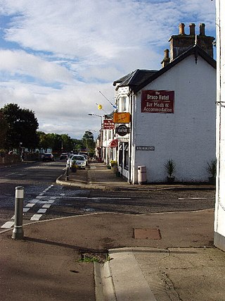
Braco is a village in Perth and Kinross, Scotland, with a population of 515. It is located 5 miles north of Dunblane towards Perth off the A9 road.

Rumbling Bridge is a small village built on both sides of a gorge of the River Devon, which formed the boundary between the historic counties of Perthshire and Kinross-shire and is now within the combined Perth and Kinross council area, Scotland, where the A823 leaves the A977. It lies roughly one mile equidistant from Muckhart to its north, Crook of Devon to its east and Powmill to its south. Comprising only a few scattered houses until the mid-20th century, most property in the village dates from the 1970s onwards.

Greenloaning is a village in Perth and Kinross, Perthshire, Scotland. It lies by the Allan Water and the Stirling-Perth Railway line. It is 1 mile south of Braco and 5 miles north of Dunblane.

Rhynd is a hamlet in Perth and Kinross, Scotland. It is located 3+1⁄4 miles southeast of Perth, on the south side of the River Tay.

Blairingone is a village in Perth and Kinross, Scotland. It lies on the A977 road at its intersection with Vicar's Bridge Road near the extreme south-westerly point of the region, approximately 3 miles southeast of Dollar. The Arndean agricultural estate lies about 1 mile northeast, near the River Devon.

Tullibardine is a location in Perth and Kinross, Scotland, which gives its name to a village, a castle and a grant of nobility.


