
Perthshire, officially the County of Perth, is a historic county and registration county in central Scotland. Geographically it extends from Strathmore in the east, to the Pass of Drumochter in the north, Rannoch Moor and Ben Lui in the west, and Aberfoyle in the south; it borders the counties of Inverness-shire and Aberdeenshire to the north, Angus to the east, Fife, Kinross-shire, Clackmannanshire, Stirlingshire and Dunbartonshire to the south and Argyllshire to the west. It was a local government county from 1890 to 1930.

Perth is a city in central Scotland, on the banks of the River Tay. It is the administrative centre of Perth and Kinross council area and the historic county town of Perthshire. It had a population of about 47,430 in 2018.

Perth and Kinross is one of the 32 council areas of Scotland and a Lieutenancy Area. It borders onto the Aberdeenshire, Angus, Argyll and Bute, Clackmannanshire, Dundee, Fife, Highland and Stirling council areas. Perth is the administrative centre. With the exception of a large area of south-western Perthshire, the council area mostly corresponds to the historic counties of Perthshire and Kinross-shire.
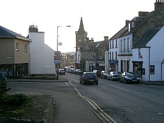
Kinross is a burgh in Perth and Kinross, Scotland, around 13 miles south of Perth and around 20 miles northwest of Edinburgh. It is the traditional county town of the historic county of Kinross-shire.

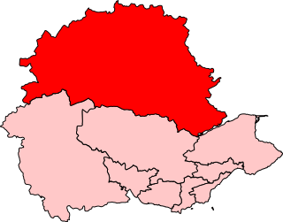
The County of Kinross or Kinross-shire is a historic county and registration county in eastern Scotland, administered as part of Perth and Kinross since 1930. Surrounding its largest settlement and county town of Kinross, the county borders Perthshire to the north and Fife to the east, south and west.

Milnathort is a small town in the parish of Orwell in the county of Kinross-shire, Scotland and since 1996, the local council area of Perth and Kinross. The smaller neighbour of nearby Kinross, Milnathort has a population of around 2,000 people. It is situated amidst countryside at the foot of the Ochil Hills, and near the north shore of Loch Leven. From 1977 it became more easily accessible due to the development of the M90 motorway. The name comes from the Gaelic maol coirthe meaning "bare hill of the standing stones".

Ochil and South Perthshire is a county constituency of the House of Commons of the Parliament of the United Kingdom. It elects one Member of Parliament (MP) by the first-past-the-post system of election.
Kinross and Western Perthshire was a county constituency of the House of Commons of the Parliament of the United Kingdom from 1918 until 1983, representing, at any one time, a seat for one Member of Parliament (MP), elected by the first past the post system of election.

Perth and Kinross Council is the local government council for the Perth and Kinross council area of Scotland. It employs around 6,000 people.

Kinnoull Hill is a hill located partly in Perth and partly in Kinfauns, Scotland. It shares its name with the nearby residential area Kinnoull.
Perthshire North is a constituency of the Scottish Parliament (Holyrood) covering part of the council area of Perth and Kinross. It elects one Member of the Scottish Parliament (MSP) by the plurality method of election. It is one of nine constituencies in the Mid Scotland and Fife electoral region, which elects seven additional members, in addition to the nine constituency MSPs, to produce a form of proportional representation for the region as a whole.

Perthshire South and Kinross-shire is a constituency of the Scottish Parliament (Holyrood) covering part of the council area of Perth and Kinross. It elects one Member of the Scottish Parliament (MSP) by the plurality method of election. Also, however, it is one of nine constituencies in the Mid Scotland and Fife electoral region, which elects seven additional members, in addition to nine constituency MSPs, to produce a form of proportional representation for the region as a whole.

Kinnesswood, possibly from the Scottish Gaelic: Ceann eas ciad is a village in Perth and Kinross, Scotland. It lies to the east of Loch Leven, on the A911 road, below Bishop Hill in the Lomond Hills. It is approximately 4 miles west of Glenrothes and 4 miles east of Kinross.

Carsehall is a village in Perth and Kinross, Scotland. It is northeast of Loch Leven and west of Bishop Hill in the Lomond Hills. It is on the A911 road at its junction with the B919 road. It is approximately 5 miles west of Glenrothes and 3 miles east of Kinross. It is the location of the Balgedie Toll Tavern.
Perth Academy is a state comprehensive secondary school in Perth, Scotland. It was founded in 1696. The institution is a non-denominational one. The school occupies ground on the side of a hill in the Viewlands area of Perth, and is within the Perth and Kinross Council area.
The Railways of Kinross were a local network of three rural railways which made the town of Kinross in Scotland their objective in the 1850s.

Garrow is a clachan in the Breadalbane region of Perth and Kinross, Scotland. It is located about midway between Kenmore, 4.5 miles to the northwest, and Amulree, 5.3 mi (8.5 km) to the southeast. It sits below the River Quaich, which flows into nearby Loch Freuchie, itself situated between Garrow and Amulree, 2.3 mi (3.7 km) away. Garrow's elevation is about 314 metres.

Craigie is a residential area of Perth, Scotland, immediately to the south and southwest of the city centre, beyond the South Inch. It is situated in the foothills of the 430 feet (130 m) St Magdalene's Hill, over which the M90 motorway passes, as does the B9112. It is separated from the city by the Highland Main Line.
