Rumbling Bridge

Last updated
Rumbling Bridge, the double bridge which gives its name to the village The bridges at Rumbling Bridge Gorge - geograph.org.uk - 2055419.jpg
Rumbling Bridge, the double bridge which gives its name to the village

Rumbling Bridge is a small village built on both side of a gorge of the River Devon, which formed the boundary between the historic counties of Perthshire and Kinross-shire and is now within the combined Perth and Kinross council area, Scotland, where the A823 leaves the A977. [1] It lies roughly 1 mile equidistant from Muckhart to its north, Crook of Devon to its east and Powmill to its south. It is named after an unusual double bridge, which gives off a distinctive rumbling reverberation at lower levels. Comprising only a few scattered houses until the mid-20th century, most property in the village dates from the 1970s onwards.

Contents

The bridge

The lower bridge, above the deep narrow gorge which causes the rumble Rumbling Bridge - geograph.org.uk - 717709.jpg
The lower bridge, above the deep narrow gorge which causes the rumble

The "lower" bridge, without parapets, was built in 1713 [1] by William Gray, a mason from Saline. It is 22 feet (6.7 metres) long, 11 ft (3.4 m) wide, and 86 ft (26 m) above the average water level.

The second bridge or Upper Arch (120 feet or 37 metres above the river) was constructed 34 feet (10 metres) above it in 1816 [1] and gave it an easier gradient [2] by removing the steep slope down to the old bridge. On 18 March that year there was "the greatest flood ever heard of or seen in Kinross; all the burns were brimfull". [2] On 13 August, "a smart shock of earthquake was felt throughout Kinross at 11 o'clock at night. Plates rattled on shelves; chairs moved about and were thrown over; beds shook, &c." [2] There was also a "wet and late harvest" [2] during which there was snow on four occasions from five to six inches (130 to 150 mm) deep.

The river

Unlike the Rumbling Bridge over the River Braan near Dunkeld, the River Devon cannot be canoed. There is a good, well maintained path round the upper gorge built by the armed forces. About 350 yards (320 m) above the bridges is the Devil's Mill waterfall. At the Devil's Mill, the river runs through a rocky channel into a deep basin, descending into a cavity beneath where the rushing of water produces a sound which the 1838 guidebook The Scottish Tourist compares to "that made by the machinery of a mill in motion". [3] The best view of it is from the south bank. [3]

Scenery

Taking the footpath east from here will take you right through to the Crook of Devon. From west of the Rumbling Bridge there is no safe path although an 1838 guidebook The Scottish Tourist says that "the best view of the finely wooded cliffs connected by the Rumbling Bridge, is from a gentle eminence immediately below and opposite to it, upon the north bank. The river, both above and below, bounding from rock to rock, each forming a little cataract, creates a constant tumbling noise; hence the name of the Rumbling Bridge. From the clefts in the face of the rock grow bushes and trees, among which daws and hawks nestle, and from these they are incessantly sporting, thereby giving a pleasing animation to the scene." [3]

Cauldron Linn Cauldron Linn waterfall on the river Devon - geograph.org.uk - 1947928.jpg
Cauldron Linn

The lower gorge is not easily accessible although Caldron Linn (1 mile or 1.5 kilometres below Rumbling Bridge), accessed through fields by Powmill, is worth the effort and the 150-foot (45-metre) slippery descent to reach it.

The gorge is fairly dangerous. In May 1849, a young boy James Anderson was killed after falling one hundred feet (30 m) from the high rocks to the west of the Rumbling Bridge while birdnesting. [2] And on 6 August 2002, after heavy rains and flash flooding, 16-year Alix-Ann Aisin MacKay fell into the gorge and died whilst trying to cross it with friends.

Environs

The Scripture Union runs an activity centre in the nearby Naemoor House (formerly Lendrick Muir School). Lendrick Muir School was funded by the Colin Nikolic Foundation, run by the former pupil and Head Boy of Lendrick Muir School.

Tourism

On 1 May 1863 Kinross railway line was extended to Rumbling Bridge and Rumbling Bridge railway station was built. The line was extended to Dollar on 15 April 1871. It had taken two years to complete this short, but difficult route. This opened the gorge up to curious Victorians travelling out from Edinburgh and the Rumbling Bridge Hotel was built.

It was a very popular tourist destination even before the railway was built. The clear winding Devon," was celebrated by Robert Burns in his beautiful lyric, "The Banks of the Devon." Miss Charlotte Hamilton (afterwards Mrs. Adair), was the "Loveliest flower on the banks of the Devon" whom Burns met during a visit to the Cauldron Linn on Thursday 30 August 1787. She was at that time residing at Harvieston, near Dollar.

Famous residents

Related Research Articles

<span class="mw-page-title-main">Perthshire</span> Historic administrative division in Scotland

Perthshire, officially the County of Perth, is a historic county and registration county in central Scotland. Geographically it extends from Strathmore in the east, to the Pass of Drumochter in the north, Rannoch Moor and Ben Lui in the west, and Aberfoyle in the south; it borders the counties of Inverness-shire and Aberdeenshire to the north, Angus to the east, Fife, Kinross-shire, Clackmannanshire, Stirlingshire and Dunbartonshire to the south and Argyllshire to the west. It was a local government county from 1890 to 1930.

<span class="mw-page-title-main">Perth and Kinross</span> Council area of Scotland

Perth and Kinross is one of the 32 council areas of Scotland and a lieutenancy area. It borders onto the Aberdeenshire, Angus, Argyll and Bute, Clackmannanshire, Dundee, Fife, Highland and Stirling council areas. Perth is the administrative centre. With the exception of a large area of south-western Perthshire, the council area mostly corresponds to the historic counties of Perthshire and Kinross-shire.

<span class="mw-page-title-main">River Dee, Aberdeenshire</span> River in Aberdeenshire, Scotland

The River Dee is a river in Aberdeenshire, Scotland. It rises in the Cairngorms and flows through southern Aberdeenshire to reach the North Sea at Aberdeen. The area it passes through is known as Deeside, or Royal Deeside in the region between Braemar and Banchory because Queen Victoria came for a visit there in 1848 and greatly enjoyed herself. She and her husband, Prince Albert, built Balmoral Castle there which replaced an older castle.

<span class="mw-page-title-main">Alyth</span> Human settlement in Scotland

Alyth is a town in Perth and Kinross, Scotland, five miles northeast of Blairgowrie and about 17 miles northwest of Dundee. In 2016 the town had an estimated population of 2,400.

<span class="mw-page-title-main">Acharn, Perth and Kinross</span> Human settlement in Scotland

Acharn is a hamlet in the Kenmore parish of the Scottish council area of Perth and Kinross. It is situated on the south shore of Loch Tay close to its eastern end. The hamlet was built in the early 19th century to house workers from the surrounding estates. A watermill was constructed to harness the power of the nearby Acharn Burn, and this was converted into a craft centre in the 1970s, and later into a private residence. There is a bridge in the middle that goes over the Acharn burn.

<span class="mw-page-title-main">River Bladnoch</span>

The Bladnoch is a river in Wigtownshire in the Machars of Galloway in southwest Scotland. One of the earliest descriptions of it is given by Sir Andrew Agnew of Lochnaw and Sir David Dunbar in an appendix to Andrew Symson's work "A Large Description of Galloway" written in the 17th century. In this they state that:

Blaidzenoch which floweth from the mountnous parts of Penninghame, and runs from the north to the south. It runneth through Lochmabary, and by the way it receaveth into several waters; the most considerable is the water of Tarfe, which hath its rise from Airtfeeld, in the Muirs of Luce, and falleth into Blaidzenoch, under the house of Craighlaw. The Blaidzenoch turns to the east, and after it heth fra its source run twenty miles (32 km), it falleth into the Bay of Wigtown, near above the place of Baldone.

<span class="mw-page-title-main">Muir of Ord</span> Human settlement in Scotland

Muir of Ord is a village in Easter Ross, in the Highland council area of Scotland. It is situated near the western end of the Black Isle, about 9 miles (14 km) west of the city of Inverness and 5+12 miles (9 km) south of Dingwall. The village has a population of 2,840 and sits 35 metres (115 ft) above sea level. The Scottish geologist Sir Roderick Murchison was born in the village in 1792.

Tillietudlem is a fictional castle in Walter Scott's 1816 novel Old Mortality, and a modern settlement in South Lanarkshire, Scotland.

<span class="mw-page-title-main">Falls of Bruar</span> Waterfall in Perth and Kinross, Scotland

The Falls of Bruar are a series of waterfalls on the Bruar Water in Scotland, about 8 miles from Pitlochry in the council area of Perth and Kinross. They have been a tourist attraction since the 18th century and were immortalized in a poem by Robert Burns, The Humble Petition of Bruar Water to the Noble Duke of Atholl, supposedly from the river itself entreating the Duke to plant some trees in the then barren landscape.

<span class="mw-page-title-main">Crook of Devon</span> Human settlement in Scotland

Crook of Devon is a village within the parish of Fossoway in Kinross-shire about six miles west of Kinross on the A977 road. Its name derives from the nearly 180-degree turn, from generally eastwards to generally westwards and resembling the shape of a shepherd's crook, which the River Devon makes at the village.

<span class="mw-page-title-main">Powmill</span> Human settlement in Scotland

Powmill is a village in Perth and Kinross, Scotland. It lies at the junction of the A823 and A977 roads at the southwest of the region, approximately 5 miles southwest of Kinross and 5 miles east of Dollar.

Lendrick Muir School was a Scottish residential school for children of above average intelligence, aged 11–19 or latterly children with dyslexia, located in Perth and Kinross on an unclassified road from Rumbling Bridge to Crook of Devon.

<span class="mw-page-title-main">Devon Valley Railway</span> Former railway line in Scotland

The Devon Valley Railway linked Alloa and Kinross in central Scotland, along a route following the valley of the River Devon. Its construction took 20 years from the first section opening in 1851, to the final section in 1871. Three railway companies were involved, and it encountered a great many problems both with finance and engineering.

<span class="mw-page-title-main">Haugh, East Ayrshire</span> Human settlement in Scotland

Haugh or The Haugh is a small village or hamlet in East Ayrshire, Parish of Mauchline, Scotland. The habitation is situated about two and a half miles downstream from Catrine, on the north bank of the River Ayr. The River Ayr Way runs through the village.

<span class="mw-page-title-main">Cauldron Linn (River Devon)</span> Waterfall

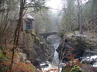
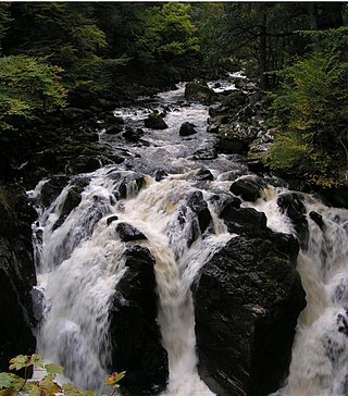
Cauldron Linn, or Caldron Linn, is a waterfall on the River Devon on the border between Clackmannanshire and Perth and Kinross in Scotland.

<span class="mw-page-title-main">Fingle Bridge</span> Bridge over the River Teign in Devon, England

Fingle Bridge is a 17th-century stone arch bridge carrying an unclassified road over the River Teign near Drewsteignton, within Dartmoor National Park in Devon, England. This packhorse bridge has three arches and the two central piers are surrounded by triangular cutwaters extending upwards to form pedestrian refuges, and is a Grade II* listed building.

The Railways of Kinross were a local network of three rural railways which made the town of Kinross in Scotland their objective in the 1850s.

<span class="mw-page-title-main">Rumbling Bridge railway station</span> Disused railway station in Rumbling Bridge, Kinross-shire

Rumbling Bridge railway station served the village of Rumbling Bridge, Kinross-shire, Scotland from 1863 to 1964 on the Devon Valley Railway.

<span class="mw-page-title-main">Hermitage Bridge (Dunkeld, Scotland)</span> Stone bridge in Scotland

The Hermitage Bridge is an ancient, single-arch stone pedestrian bridge crossing the River Braan near Dunkeld, Perth and Kinross, Scotland. A Category A listed structure, it is in the bounds of The Hermitage, a National Trust for Scotland-protected site. The bridge should not be confused with the Rumbling Bridge, which carries motorised traffic, about 0.62 miles (1.00 km) to the southwest.

<span class="mw-page-title-main">Black Linn Falls</span> Waterfall in Dunkeld, Scotland

Black Linn Falls is a waterfall on the River Braan in The Hermitage, Dunkeld, Scotland. After the falls, the river passes beneath the Hermitage Bridge into a plunge pool.

References

  1. 1 2 3 "Rumbling Bridge". Gazetteer for Scotland. Retrieved 15 December 2014.
  2. 1 2 3 4 5 "Kinross Museum Official Website".
  3. 1 2 3 The Scottish Tourist, and Itinerary; being A Guide to the Scenery and Antiquities of Scotland and the Western Islands. Edinburgh: Stirling, Kenney, & Co. 1838. pp.  129–130.
56°10′39″N3°35′07″W / 56.17750°N 3.58528°W / 56.17750; -3.58528