
Atholl or Athole is a district in the heart of the Scottish Highlands, bordering Marr, Gowrie, Perth, Strathearn, Breadalbane, Lochaber, and Badenoch. Historically it was a Pictish kingdom, becoming one of the original provinces of the Kingdom of Alba before being incorporated into the sheriffdom and later county of Perthshire. Today it forms the northern part of Perth and Kinross, Scotland.

Crail is a former royal burgh, parish and community council area in the East Neuk of Fife, Scotland.

The Brough of Birsay is an uninhabited tidal island off the north-west coast of The Mainland of Orkney, Scotland, in the parish of Birsay. It is located around 13 miles north of Stromness and features the remains of Pictish and Norse settlements as well as a modern lighthouse.

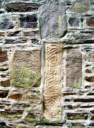
A Pictish stone is a type of monumental stele, generally carved or incised with symbols or designs. A few have ogham inscriptions. Located in Scotland, mostly north of the Clyde-Forth line and on the Eastern side of the country, these stones are the most visible remaining evidence of the Picts and are thought to date from the 6th to 9th century, a period during which the Picts became Christianized. The earlier stones have no parallels from the rest of the British Isles, but the later forms are variations within a wider Insular tradition of monumental stones such as high crosses. About 350 objects classified as Pictish stones have survived, the earlier examples of which holding by far the greatest number of surviving examples of the mysterious symbols, which have long intrigued scholars.
Fyvie is a village in the Formartine area of Aberdeenshire, Scotland.

The National Monument of Scotland, on Calton Hill in Edinburgh, is Scotland's national memorial to the Scottish soldiers and sailors who died fighting in the Napoleonic Wars. It was intended, according to the inscription, to be "A Memorial of the Past and Incentive to the Future Heroism of the Men of Scotland".

Scone Palace is a Category A-listed historic house near the village of Scone and the city of Perth, Scotland. Ancestral seat of Earls of Mansfield, built in red sandstone with a castellated roof, it is an example of the Gothic Revival style in Scotland.
Inveresk is a village in East Lothian, Scotland situated 5⁄8 mi (1 km) to the south of Musselburgh. It has been designated a conservation area since 1969. It is situated on slightly elevated ground on the north bank of a loop of the River Esk. This ridge of ground, 20 to 25 metres above sea level, was used by the Romans as the location for Inveresk Roman Fort in the 2nd century AD.

Dalmeny is a village and civil parish in Scotland. It is located on the south side of the Firth of Forth, 1 mile (1.6 km) southeast of South Queensferry and 8 miles (13 km) west of Edinburgh city centre. It lies within the traditional boundaries of West Lothian, and falls under the local governance of the City of Edinburgh Council. Dalmeny is on the route used as the X99 Queensferry off-service loop.

Dunkeld is a town in Perth and Kinross, Scotland. The location of a historic cathedral, it lies on the north bank of the River Tay, opposite Birnam. Dunkeld lies close to the geological Highland Boundary Fault, and is frequently described as the "Gateway to the Highlands" due to its position on the main road and rail lines north. Dunkeld has a railway station, Dunkeld & Birnam, on the Highland Main Line, and is about 25 kilometres north of Perth on what is now the A9 road. The main road formerly ran through the town, however following the modernisation of this road it now passes to the west of Dunkeld.
Fortingall is a small village in Glen Lyon, Perthshire, Scotland. Its nearest sizable neighbours are Aberfeldy and Kenmore.

Forteviot is a village in Strathearn, Perth and Kinross on the south bank of the River Earn between Dunning and Perth. It lies in the council area of Perth and Kinross. The population in 1991 was 160.

Arbirlot is a village in a rural parish of the same name in Angus, Scotland. The current name is usually presumed to be a contraction of Aberelliot or Aber-Eliot, both meaning the mouth of the Elliot. It is situated west of Arbroath. The main village settlement is on the Elliot Water, 2+1⁄2 miles (4 km) from Arbroath. There is a Church of Scotland church and a primary school. The school lies 1 mile (1.6 km) further west, in the approximate geographic centre of the parish.

The Eassie Stone is a Class II Pictish stone of about the mid 8th century AD in the village of Eassie, Angus, Scotland. The stone was found in Eassie burn in the late 18th century and now resides in a purpose-built perspex building in the ruined Eassie church.

The Battle of Barry is a legendary battle in which the Scots, purportedly led by Malcolm II, defeated a Danish invasion force in 1010 AD. Its supposed site in Carnoustie, Angus can be seen in early Ordnance Survey maps. The history of the event relies heavily on tradition and it is considered to be apocryphal. The battle was named for the Parish of Barry, rather than the village, and was formerly thought to have taken place at the mouth of the Lochty burn, in the vicinity of the area that is now occupied by Carnoustie High Street. While the battle is not historically authentic, its romantic appeal continues to capture the popular imagination.

Kinneddar is a small settlement on the outskirts of Lossiemouth in Moray, Scotland, near the main entrance to RAF Lossiemouth. Long predating the modern town of Lossiemouth, Kinneddar was a major monastic centre for the Pictish kingdom of Fortriu from the 6th or 7th centuries, and the source of the important collection of Pictish stones called the Drainie Carved Stones. The Kirk of Kinneddar was the cathedral of the Diocese of Moray between 1187 and 1208, and remained an important centre of diocesan administration and residence of the Bishop of Moray through the 13th and 14th centuries.

Richard and Robert Dickson were brothers, acting as architects in Scotland in the early and mid-19th century. Whilst most of their work is typified by remote country houses they are best known for their magnificent spire on the Tron Kirk in the heart of Edinburgh on the Royal Mile.

The Knock of Alves is a small wooded hill that lies 3 miles (4.8 km) to the west of Elgin in Moray, Scotland, rising to 335 feet (102 m) above ordnance datum. Its summit is marked by York Tower, a 3-storey octagonal folly erected in 1827 to commemorate Prince Frederick, the Duke of York; and the Forteath Mausoleum, built in 1850 as the burial place of 7 members of the Forteath family of the nearby house of Newton.

Midmar is a historic settlement in Aberdeenshire, lying north of Banchory and southwest of Inverurie. It is noted for its three stone circles and various standing stones. Midmar and Sunhoney are both recumbent stone circles.

Mortlach Parish Church is a church within the Church of Scotland serving the parish of Mortlach, in Moray, close to the village of Dufftown. The site of the church has long been associated with Christianity, going back perhaps as far as 566 when St Moluag is said to have founded a religious community there. A Class II Pictish stone, dating from between the seventh and ninth centuries, was discovered there, which can now be seen in the burial ground. There was a bishopric on the site in the eleventh and twelfth centuries, prior to it being moved to Aberdeen in the reign of King David I. The current church retains some of the fabric of a thirteenth-century structure, which has been repeatedly remodelled in the centuries that followed, most recently in 1931. The church, along with the surrounding burial ground and a watch house within the grounds, has been designated a Category A listed building.

