
Perth is a city in central Scotland, on the banks of the River Tay. It is the administrative centre of Perth and Kinross council area and the historic county town of Perthshire. It had a population of about 47,180 in 2012. Perth has been known as The Fair City since the publication of the story Fair Maid of Perth by Scottish writer Sir Walter Scott in 1828. During the later medieval period the city was also called St John's Toun or Saint Johnstoun by its inhabitants—a reference to its principal church, which was dedicated to St John the Baptist. This name is preserved in the name of the city's football club, St Johnstone F.C. Perth is twinned with Aschaffenburg in the German state of Bavaria and there are several places in the world named after Scotland’s Perth, including Perth in Western Australia, Perth in Tasmania, and Perth in Ontario, Canada.
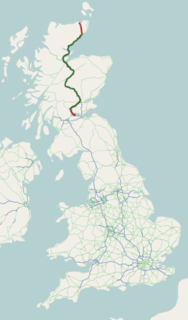
The A9 is a major road running from the Falkirk council area in central Scotland to Scrabster Harbour, Thurso in the far north, via Stirling, Bridge of Allan, Perth and Inverness. At 273 miles (439 km), it is the longest road in Scotland and the fifth-longest A-road in the United Kingdom. Historically it was the main road between Edinburgh and John o' Groats, and has been called the spine of Scotland. It is one of the three major north-south trunk routes linking the Central Belt to the Highlands - the others being the A82 and the A90.

Abernethy is a village in Perth and Kinross, Scotland, situated 8 miles (13 km) south-east of Perth.
Newburgh is a royal burgh and parish in Fife, Scotland, at the south shore of the Firth of Tay. The town has a population of 2,171, which constitutes a 10% increase since 1901 when the population was counted at 1,904 persons.

Trecastle is a village in Powys, Wales, situated on the edge of the Brecon Beacons National Park (Welsh: Parc Cenedlaethol Bannau Brycheiniog) and in the community of Llywel.

Pencaitland is a village in East Lothian, Scotland, about 12 miles south-east of Edinburgh, 5 mi (8 km) south-west of Haddington, and 1 mi (2 km) east of Ormiston.

Kilmacolm is a village and civil parish in the Inverclyde council area, and the historic county of Renfrewshire in the west central Lowlands of Scotland. It lies on the northern slope of the Gryffe Valley, 7+1⁄2 miles southeast of Greenock and around 15 miles (24 km) west of the city of Glasgow. The village has a population of around 4,000 and is part of a wider civil parish which covers a large rural hinterland of 15,000 hectares containing within it the smaller settlement of Quarrier's Village, originally established as a 19th-century residential orphans' home.

Liff is a village in Angus, Scotland, situated 4.5 miles west-north-west of Dundee on a south-facing slope two miles north of the River Tay. It had a population of 568 in 2011. Surrounded by farmland, it has been described as 'haunted by wood pigeons and the scent of wild garlic' and having a 'wonderful view over the firth [of Tay]'. Half a mile to the east lies the site of the former Royal Dundee Liff Hospital, now given over to private housing. Further east lie Camperdown House and Park. Half a mile to the south is House of Gray, a large eighteenth-century mansion house in the neoclassical style, currently standing empty. The village contains twelve listed buildings, with others nearby.

Dunkeld is a town in Perth and Kinross, Scotland, a historic cathedral "city" on the north bank of the River Tay, opposite Birnam. It lies close to the geological Highland Boundary Fault, and is frequently described as the "Gateway to the Highlands" due to its position on the main road and rail lines north. Dunkeld has a railway station, Dunkeld & Birnam, on the Highland Main Line, and is about 25 kilometres north of Perth on what is now the A9 road. The main road formerly ran through the town, however following modernisation of this road it now passes to the west of Dunkeld.

Bridge of Earn is a small town in Perthshire, Scotland. Often referred to simply as 'The Brig'. The village grew up on the south bank of an important crossing of the River Earn, whose sandstone bridge existed from at least the early 14th century, when it is known to have been repaired by order of King Robert I of Scotland (1306–1329). Substantial remains of the medieval bridge survived into the 1970s, when almost all the stonework was demolished, for (allegedly) being in a dangerously ruinous condition. This ancient bridge was a major landmark on the road between Edinburgh and Perth for several centuries. The village's oldest houses are to be found lining the road leading south from the site of the demolished bridge. Among them are some with 18th-century datestones.
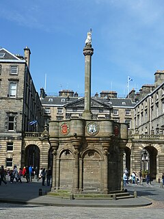
A mercat cross is the Scots name for the market cross found frequently in Scottish cities, towns and villages where historically the right to hold a regular market or fair was granted by the monarch, a bishop or a baron. It therefore served a secular purpose as a symbol of authority, and was an indication of a burgh's relative prosperity. Historically, the term dates from the period before 1707, when the Kingdom of Scotland was an independent state, but it has been applied loosely to later structures built in the traditional architectural style of crosses or structures fulfilling the function of marking a settlement's focal point. Historical documents often refer simply to "the cross" of whichever town or village is mentioned. Today, there are around 126 known examples of extant crosses in Scotland, though the number rises if later imitations are added.

Forteviot is a village in Strathearn, Scotland on the south bank of the River Earn between Dunning and Perth. It lies in the council area of Perth and Kinross. The population in 1991 was 160.
Longforgan is a village and parish in the Carse of Gowrie, in Perth and Kinross, Scotland. It lies 5 miles west of Dundee on the main A90 road.

Kirkmichael is a village located in Strathardle, Perth and Kinross, Scotland. It is 13 miles north-northwest of Blairgowrie and 12 miles east-northeast of Pitlochry on the A924 Bridge of Cally to Pitlochry road, and is linked to the A93 Perth to Aberdeen road by the B950. The village is centred around the bridge over the River Ardle.
Innerwick is a coastal civil parish and small village, which lies in the east of East Lothian, 5 miles (8.0 km) from Dunbar and approximately 32 miles (51 km) from Edinburgh.

Heasta, Heast, or the anglicised form Heaste, pron. /heɪst/, is a small settlement on the island of Skye, Scotland. It is located on the west coast of the island five miles south of Broadford extending down to the north shore of Loch Eiseort, facing out to the Atlantic to the south west and is in the Scottish council area of Highland.
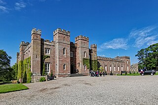
Scone is a town in Perth and Kinross, Scotland. The medieval town of Scone, which grew up around the monastery and royal residence, was abandoned in the early 19th century when the residents were removed and a new palace was built on the site by the Earl of Mansfield. Hence the modern village of Scone, and the medieval village of Old Scone, can often be distinguished.

Closeburn is a village and civil parish in Dumfries and Galloway, Scotland. The village is on the A76 road 2+1⁄2 miles (4 km) south of Thornhill. In the 2001 census, Closeburn had a population of 1,119. Closeburn is recorded as Killosbern in 1185. The first element of the name is Gaelic cill 'cell or church'. The second element is a saint's name, but none has definitely been identified.
Bowden is a village in the Roxburghshire area of the Scottish Borders, situated 3 miles south of Melrose, 2 miles west of Newtown St Boswells and tucked in the shadow of the Eildon Hills, Scotland.
