
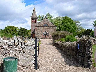
Airlie is a civil parish in the Scottish council area of Angus. It is the seat of the Earl of Airlie, and the location of Airlie Castle. It comprises Craigton of Airlie, Baitland of Airlie and Kirkton of Airlie. There is a standing stone in a field just east of the Baitland; various Pictish and Roman relics have been uncovered and the primary school is reputed to have been built on the site of an old graveyard. Airlie also contains one of the finest examples of a Pictish souterrain in Scotland, with the carving of a snake clearly visible in the ceiling.
Finegand is a farming hamlet located in eastern Perth and Kinross, Scotland and also refers historically to the portion of lands surrounding the hamlet. Finegand is located in Glen Shee and encompasses the lands east of the Shee Water adjacent to a burn which joins it about 4 miles below the Spittal and about 18 miles north of Blairgowrie.

Bridge of Craigisla is a hamlet in Angus, Scotland. The bridge crosses the River Isla. This settlement lies along the B954 road.
Aultmore is a village in Moray, Scotland, near Keith.

Kilspindie is a village in Perth and Kinross, Scotland. It is situated on the Kilspindie burn, approximately 2+3⁄4 miles northwest of Errol, 12 miles west of Dundee centre and 6+1⁄2 miles east of Perth. The village has an area of 6,500 acres of which 3,500 acres are arable land and 200 acres are woodland, the local geology is mostly whinstone, amygdule and trap. Records show there was a chapel in the village since at least 1214 though the current church, the Kilspindie and Rait Parish Church, was built in 1670 and refurbished in 1938. The village previously housed the Kilspindie Castle which was demolished before 1670.
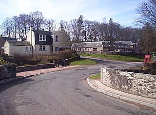
Bridgend of Lintrathen is a village in Angus, Scotland. It is situated on the southern shore of Loch of Lintrathen, six miles west of Kirriemuir.
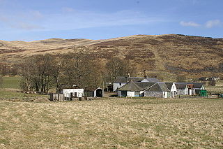
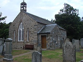
Kirkton of Glenisla consists of a church and graveyard, a hotel, hall and several homes forming the largest concentration of habitation in Glenisla, Angus, Scotland. It is situated on the River Isla, eleven miles north-west of Kirriemuir and ten miles north of Blairgowrie, on the B951 road. The kirkton is situated adjacent to the 64 mile waymarked Cateran Trail. There is a suspension footbridge that was built in 1824 over the River Isla.
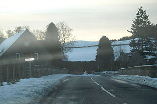
Brewlands Bridge is a hamlet in Glen Isla, Angus, Scotland. It is lies situated on the River Isla, eleven miles north-west of Kirriemuir and ten miles north of Blairgowrie, on the B951 road.
Folda is a hamlet in Glen Isla, Angus, Scotland. It is situated on the River Isla, twelve miles north-west of Kirriemuir and eleven miles north of Blairgowrie, on the B951 road.

Little Forter is a hamlet in Glen Isla, Angus, Scotland. It is on the River Isla, 13 miles north-west of Kirriemuir and 11 miles north of Blairgowrie, on the B951 road.
Dowally is a village and parish in Perth and Kinross, Scotland. It lies 3+1⁄2 miles (5.6 km) north of Dunkeld on the A9 road.

Woodside is a small village in Scotland, 12 miles from Perth, in the Perth and Kinross council area. It is joined onto another village, Burrelton. It is 2 miles from Coupar Angus, the nearest town.
Kettins is a village in Perth and Kinross, Scotland about 14 miles northeast of Perth and 11 miles northwest of Dundee. It is 1 mile from Coupar Angus, north of the A923 road.

Caputh is a parish and village in Perth and Kinross, Scotland. It lies on the A984 Coupar Angus to Dunkeld road about 6 miles southeast of Dunkeld and 8 miles west of Coupar Angus.
Balbeggie is a village in Perth and Kinross, Scotland about 7 miles northeast of Perth on the A94 road.
Campmuir is a small village in the Perth and Kinross area of Scotland.

The Craigie Waggonway was a short lived mineral railway or 'Bogey line' of just over a mile in length that transported coal from five or more coal pits on the Craigie Estate to Ayr where it was either used locally or was taken to the harbour in carts for export, mainly to Ireland.
The 2021–22 Midlands Football League is the inaugural season of the Midlands Football League, the sixth tier of the Scottish football pyramid system. The season began with nine games on 17 July 2021.

