
Perthshire, officially the County of Perth, is a historic county and registration county in central Scotland. Geographically it extends from Strathmore in the east, to the Pass of Drumochter in the north, Rannoch Moor and Ben Lui in the west, and Aberfoyle in the south; it borders the counties of Inverness-shire and Aberdeenshire to the north, Angus to the east, Fife, Kinross-shire, Clackmannanshire, Stirlingshire and Dunbartonshire to the south and Argyllshire to the west. It was a local government county from 1890 to 1930.

Atholl or Athole is a large historical division in the Scottish Highlands, bordering Marr, Badenoch, Lochaber, Breadalbane, Strathearn, Perth, and Gowrie. Historically it was a Pictish kingdom, becoming one of the original provinces of the Kingdom of Alba before being incorporated into the sheriffdom and later county of Perthshire. Today it forms the northern part of Perth and Kinross, Scotland.

Pitlochry is a town in the Perth and Kinross council area of Scotland, lying on the River Tummel. It is historically in the county of Perthshire, and has a population of 2,776, according to the 2011 census.

Aberfeldy is a burgh in Perth and Kinross, Scotland, on the River Tay. A small market town, Aberfeldy is located in Highland Perthshire. It was mentioned by Robert Burns in the poem The Birks Of Aberfeldy.
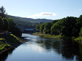
The River Tummel is a river in Perth and Kinross, Scotland. Water from the Tummel is used in the Tummel hydro-electric power scheme, operated by SSE.

Dunkeld & Birnam railway station serves the town of Dunkeld and village of Birnam in Perth and Kinross, Scotland. It is located on the Highland Main Line, 15 miles 31 chains (24.8 km) north of Perth and is the first stop on the line north of there, before Pitlochry. Most services are operated by ScotRail, who also manage the station. LNER and Caledonian Sleeper also call some services here.
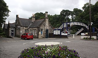
Pitlochry railway station is a railway station serving the town of Pitlochry in Perth and Kinross, Scotland. It is managed by ScotRail and is located on the Highland main line, 28 miles 21 chains (45.5 km) from Perth, between Dunkeld & Birnham and Blair Atholl.

Dalwhinnie railway station is a railway station serving the village of Dalwhinnie, Highland, Scotland. The station is managed by ScotRail and is on the Highland Main Line, 58 miles 47 chains (94.3 km) from Perth, between Blair Atholl and Newtonmore. There is a crossover at the south end of the station to allow trains to turn back if the line north to Newtonmore is closed.
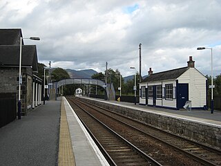
Blair Atholl railway station is a railway station serving the town of Blair Atholl, Perth and Kinross, Scotland. The station is managed by ScotRail and is on the Highland Main Line, 35 miles 9 chains (56.5 km) from Perth, between Pitlochry and Dalwhinnie. There is a crossover at the north end of the station to allow trains to turn back if the line south to Pitlochry is closed.
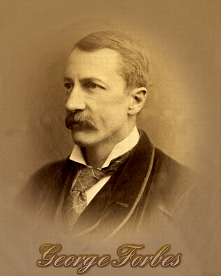
George Forbes (1849–1936) was a Scottish electrical engineer, astronomer, explorer, author and inventor, some of whose inventions are still in use.
Aberfeldy railway station served the village of Aberfeldy in Scotland.
The PH postcode area, also known as the Perth postcode area, is a group of 43 postcode districts for post towns: Aberfeldy, Acharacle, Arisaig, Auchterarder, Aviemore, Ballachulish, Blairgowrie, Boat of Garten, Carrbridge, Corrour, Crieff, Dalwhinnie, Dunkeld, Fort Augustus, Fort William, Glenfinnan, Grantown-on-Spey, Invergarry, Isle of Canna, Isle of Eigg, Isle of Rum, Kingussie, Kinlochleven, Lochailort, Mallaig, Nethy Bridge, Newtonmore, Perth, Pitlochry, Roy Bridge and Spean Bridge in Scotland.
The Inverness and Perth Junction Railway (I&PJR) was a railway company that built a line providing a more direct route between Inverness and the south for passengers and goods. Up to the time of its opening, the only route was a circuitous way through Aberdeen. The I&PJR was built from a junction with the friendly Inverness and Aberdeen Junction Railway at Forres to the Perth and Dunkeld Railway at Dunkeld.
National Cycle Route 7 is a route of the National Cycle Network, running from Sunderland to Inverness.
Isaac Slater was a British publisher of trade directories.
James Pigot was a British publisher of directories, and a pioneering publisher of trade directories.
The Sheriff of Edinburgh was historically the royal official responsible for enforcing law and order and bringing criminals to justice in the shire of Edinburgh in Scotland. In 1482 the burgh of Edinburgh itself was given the right to appoint its own sheriff, and thereafter the sheriff of Edinburgh's authority applied in the area of Midlothian outside the city, whilst still being called the sheriff of Edinburgh. Prior to 1748 most sheriffdoms were held on a hereditary basis. From that date, following the Jacobite uprising of 1745, they were replaced by salaried sheriff-deputes, qualified advocates who were members of the Scottish Bar.

Tay Forest Park is forest park in the council area of Perth and Kinross in Scotland. It consists of a network of forests managed by Forestry and Land Scotland (FLS) that are spread across the Highland parts of Perthshire, and covers 194 km2 in total. The park contains a series of disparate woods that are managed for multiple benefits, with an emphasis on recreation facilities for visitors.

Ballechin Wood is a large coniferous forest site, around 805 acres (326 ha) in area, located above Ballechin in Perth and Kinross, Scotland. It is located a short distance northwest of where the River Tay and River Tummel merge at Balmacneil and around 2 miles (3.2 km) south of Pitlochry. The wood merges into Clunie Wood to the northwest and Logierait Wood to the southeast.


