
Cross County is a rural Northeast Arkansas county in the Arkansas Delta. Created as Arkansas's 53rd county on November 15, 1862, Cross County contains four incorporated municipalities, including Wynne, the county seat and most populous city. It is named for Confederate Colonel David C. Cross, a political leader in the area.

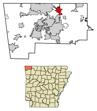
Benton County is a county in the Northwest region of the U.S. state of Arkansas. Created as Arkansas' 35th county on September 30, 1836, Benton County contains thirteen incorporated municipalities, including Bentonville, the county seat, and Rogers, the most populous city. The county was named after Thomas Hart Benton, a U.S. Senator from Missouri influential in Arkansas statehood.
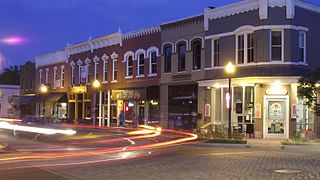
Bentonville is the ninth-most populous city in the US state of Arkansas, and the county seat of Benton County. The city is centrally located in the county with Rogers adjacent to the east. The city is the birthplace and headquarters of Walmart, the world's largest retailer. It is one of the four main cities in the three-county Northwest Arkansas Metropolitan Statistical Area, which is ranked 105th in terms of population in the United States with 546,725 residents in 2020, according to the United States Census Bureau. The city itself had a population of 54,164 at the 2020 Census, an increase of 53% from the 2010 Census. Bentonville is considered to be one of the fastest growing cities in the state and consistently ranks amongst the safest cities in Arkansas.
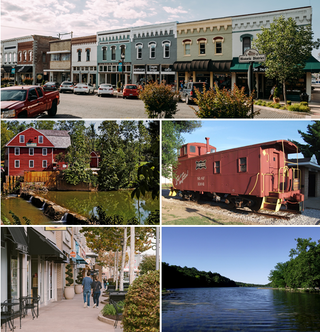
Pea Ridge is a city in Benton County, Arkansas, United States. The name Pea Ridge is derived from a combination of the physical location of the original settlement of the town, across the crest of a ridge of the Ozark Mountains, and for the hog peanuts or turkey peas that had been originally cultivated by Native American tribes centuries before European settlement, which later helped to provide basic subsistence once those pioneer settlers arrived.
Rogers is a city in Benton County, Arkansas, United States. Located in the Ozarks, it is part of the Northwest Arkansas region, one of the fastest growing metro areas in the country. Rogers was the location of the first Walmart store, whose corporate headquarters is located in neighboring Bentonville. Daisy Outdoor Products, known for its air rifles, has both its headquarters and its Airgun Museum in Rogers. The city houses a popular shopping center, the Pinnacle Hills Promenade, and a music venue, the Walmart AMP, that has housed performances by big-name artists and local performers alike.

The Battle of Pea Ridge, also known as the Battle of Elkhorn Tavern, took place during the American Civil War near Leetown, northeast of Fayetteville, Arkansas. Federal forces, led by Brig. Gen. Samuel R. Curtis, moved south from central Missouri, driving Confederate forces into northwestern Arkansas. Maj. Gen. Earl Van Dorn had launched a Confederate counteroffensive, hoping to recapture northern Arkansas and Missouri. Confederate forces met at Bentonville and became the most substantial Rebel force, by way of guns and men, to assemble in the Trans-Mississippi. Against the odds, Curtis held off the Confederate attack on the first day and drove Van Dorn's force off the battlefield on the second. By defeating the Confederates, the Union forces established Federal control of most of Missouri and northern Arkansas.
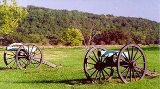
Pea Ridge National Military Park is a United States National Military Park located in northwest Arkansas near the Missouri border. The park protects the site of the Battle of Pea Ridge, fought March 7 and 8, 1862. The battle was a victory for the Union and helped it gain control of the crucial border state of Missouri.
Pea Ridge is the name of several places in the United States of America that include:
Wilson's Creek National Battlefield, located near Republic, Missouri, preserves the site of the Battle of Wilson's Creek. Fought on August 10, 1861, the battle was the first major American Civil War engagement west of the Mississippi River. In the battle, a Confederate army commanded by Benjamin McCulloch and Sterling Price defeated a smaller Union army commanded by Nathaniel Lyon. However, the Confederates were unable to hold much of Missouri, and a Confederate defeat at the Battle of Pea Ridge effectively solidified Union control of the state. Major features include a five-mile automobile tour loop, the restored 1852 Ray House, and "Bloody Hill", the site of the final stage of the battle. The site is located near Republic in southwestern Missouri just southwest of the city of Springfield. It has been a unit of the National Park Service since 1960, and was listed on the National Register of Historic Places in 1966.

Highway 72 is a designation for two east–west state highways in Benton County, Arkansas. A western route of 26.32 miles (42.36 km) runs east from Highway 43 at Maysville to U.S. Route 71B (US 71B) in Bentonville. A second route of 12.67 miles (20.39 km) begins at Interstate 49/US Route 71 (I-49/US 71) in Bentonville and runs northeast to US 62 near Avoca. The route is one of the original Arkansas state highways.
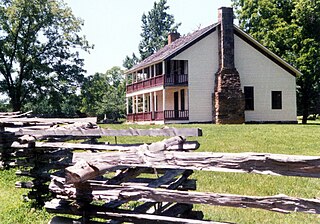
Elkhorn Tavern is a two-story, wood-frame structure that served as a physical center for the American Civil War Battle of Pea Ridge, also known as the Battle of Elkhorn Tavern, which was fought on March 7 and March 8, 1862, approximately five miles east of Pea Ridge, Arkansas, located in the northeastern Benton County, Arkansas. The tavern, a replica built in 1865 following the burning of the original building by bushwhackers, is now the centerpiece of the Pea Ridge National Military Park, which includes approximately 5,000 acres (2,000 ha) around the structure, including the restored battlefields, a stretch of the pre-war Telegraph Road, which runs directly in front of the tavern, and a section of the Trail of Tears. The tavern is on the National Register of Historic Places.
The following is an alphabetical list of articles related to the U.S. State of Arkansas.
Fort McCulloch was a Confederate military fort built by CSA Brigadier General Albert Pike in the Indian Territory during the American Civil War after the Battle of Pea Ridge.

U.S. Route 62 is a U.S. highway running from El Paso, Texas northeast to Niagara Falls, New York. In the U.S. state of Arkansas, the route runs 329.9 miles from the Oklahoma border near Summers east to the Missouri border in St. Francis, serving the northern portion of the state. The route passes through several cities and towns, including Fayetteville, Springdale, Bentonville, Harrison, Mountain Home, Pocahontas, and also Piggott. US 62 runs concurrent with several highways in Arkansas including Interstate 49 and U.S. Route 71 between Fayetteville and Bentonville, U.S. Route 412 through much of the state, U.S. Route 65 in the Harrison area, and with U.S. Route 63 and U.S. Route 67 in northeast Arkansas.

The Miller Homestead is a historic house on Benton County Route 64 in Pea Ridge, Arkansas. It is a 1+1⁄2-story wood-frame structure, with the asymmetrical massing and wraparound porch characteristic of Late Victorian houses. It was built c. 1907, and is a relatively sophisticated architectural expression for its rural setting. The property also includes a c. 1890 stone smokehouse.

The 16th Arkansas Infantry Regiment was an infantry formation in the Confederate States Army during the American Civil War. Organized from volunteer companies from northwest Arkansas, the regiment participated in the Pea Ridge Campaign before crossing the Mississippi River and becoming involved in the Iuka-Corinth Campaign and the Siege of Port Hudson. After being surrendered with the garrison of Port Hudson the unit was reorganized in Arkansas and consolidated with the remnants of several other Arkansas Regiments to become the 1st Consolidated Arkansas Infantry.
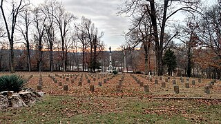
Fayetteville Confederate Cemetery is a cemetery for soldiers of the Confederate States located on the eastern side of Fayetteville in Washington County, Arkansas. Added to the National Register of Historic Places (NRHP) in 1993, the cemetery encompasses 3.5 acres (1.4 ha).
Pea Ridge High School is a comprehensive public high school located in the fringe town of Pea Ridge, Arkansas, United States. The school provides secondary education for students in grades kindergarten through 12. It is one of nine public high schools in Benton County, Arkansas and the sole high school administered by the Pea Ridge School District.
The Markey House is a historic log house in rural eastern Benton County, Arkansas. It is located on County Road 99, southeast of Garfield. It is a single-story T-shaped log structure, built in 1880 and moved to its present location in 1960. It was located on land that became part of the Pea Ridge National Military Park, and was sold by the National Park Service. It is one of the least-altered and best-preserved log buildings in the county.

The Pea Ridge Commercial Historic District encompasses the historic commercial center of Pea Ridge, Arkansas. It includes twelve buildings on Pickens Street between Greene and Davis Streets, and another seven on Curtis Street between Pike and Macintosh Streets. Of these nineteen commercial and civic buildings, thirteen are historically significant. Most of these are typical commercial buildings built between 1910 and 1930, although several date to the 1950s. Some businesses, such as Webb's Feed Store, have been in business since the early period of development, in their original premises. The town grew as an agricultural center serving first local apple growers, and then tomato growers after blight destroyed many apple orchards.


