
This is the alphabetical list of the highest points of the Indian states and territories .
This is the alphabetical list of the highest points of the Indian states and territories .
| State | Peak | Range/Region | Height (m) | Height (ft) | Coordinates | Source |
|---|---|---|---|---|---|---|
| Andaman & Nicobar Islands | Saddle Peak | North Andaman Island | 732 | 2,402 | 13°09′31″N93°00′21″E / 13.1586°N 93.0058°E | [32] |
| Chandigarh | Unnamed point | Capital Area | 383 | 1,257 | [ citation needed ] | |
| Dadra and Nagar Haveli | Unnamed point | Khanvel | 424 | 1391 | [ citation needed ] | |
| Daman and Diu | Unnamed point | Diu Island | 30 | 98 | [ citation needed ] | |
| Delhi | Fort Tughlaqabad | Delhi Ridge | 319 | 1,047 | [ citation needed ] | |
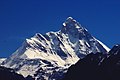
| Jammu and Kashmir | Nun Peak | Western Himalayas | 7135 | 23,409 | 33°58′51″N76°01′14″E / 33.9809°N 76.0205°E | [33] |
| Ladakh | Saltoro Kangri | Karakoram Range | 7742 | 25,400 | 35°23′56″N76°50′56″E / 35.399°N 76.849°E | [34] [35] [36] Saltoro Kangri lies along the AGPL in the Siachen area. |
| Lakshadweep | Unnamed point | Agatti Island | 15 | 49 | [ citation needed ] | |
| Puducherry | Les Montagnes Rouges | Red Hills | 30 | 98 | [ citation needed ] |


Kangchenjunga, also spelled Kanchenjunga, is the third highest mountain in the world. It rises with an elevation of 8,586 m (28,169 ft) in a section of the Himalayas called Kangchenjunga Himal delimited in the west by the Tamur River, in the north by the Lhonak Chu and Jongsang La, and in the east by the Teesta River. It lies between Nepal and Sikkim, India, with three of the five peaks directly on the border, and the remaining two in Nepal's Taplejung District.

Nanda Devi is the second highest mountain in India, and the highest located entirely within the country. It is the 23rd-highest peak in the world. It was considered the highest mountain in the world before computations in 1808 proved Dhaulagiri to be higher. It was also the highest mountain in India until 1975 when Sikkim, the state in which Kangchenjunga is located, joined the Republic of India. It is part of the Garhwal Himalayas, and is located in Chamoli district of Uttarakhand, between the Rishiganga valley on the west and the Goriganga valley on the east. The peak, whose name means "Bliss-Giving Goddess", is regarded as the patron-goddess of the Uttarakhand Himalaya. In acknowledgment of its religious significance and for the protection of its fragile ecosystem, the peak as well as the circle of high mountains surrounding it—the Nanda Devi sanctuary—were closed to both locals and climbers in 1983. The surrounding Nanda Devi National Park was declared a UNESCO World Heritage Site in 1988.

The Vindhya Range is a complex, discontinuous chain of mountain ridges, hill ranges, highlands and plateau escarpments in west-central India.

Dantewada District, also known as Dantewara District or Dakshin Bastar District, is a district in the Indian state of Chhattisgarh. Dantewada is the district headquarters. The district is part of Bastar Division. Until 1998, the Dantewada District was a tehsil of the larger Bastar District.

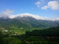
Bugyals are alpine pasture lands, or meadows, in higher elevation range between 3,300 metres (10,800 ft) and 4,000 metres (13,000 ft) of the Himalayas in the Indian state of Uttarakhand, where they are called "nature’s own gardens". The topography of the terrain is either flat or sloped. The surface of these bugyals is covered with natural green grass and seasonal flowers. They are used by tribal herdsmen to graze their cattle. During the winter season the alpine meadows remain snow-covered. During summer months, the Bugyals present a riot of beautiful flowers and grass. As bugyals constitute very fragile ecosystems, particular attention needs to be given for their conservation.

Dantewada is a town and a nagar palika in the Dantewada district in the state of Chhattisgarh, India. It is the administrative headquarters of Dantewada District. It is the fourth largest city of Bastar division.The town is named after the goddess Danteshwari, the presiding deity of the Danteshwari Temple located in the town, 80 km from the Jagdalpur tehsil. The goddess is worshipped as an incarnation of Shakti and the temple is held to be one of the fifty-two sacred Shakti Peethas.Dantewada Town is well connected by broad gauge railway line from Visakhapatnam. The Nearest city to Dantewada is Visakhapatnam
Zemu Gap Peak or Zemu Peak is a peak on a high ridge running east of the south summit of Kangchenjunga in the Himalayas. It is located in Sikkim, India. It is one of the highest unclimbed named peaks of the world. There have been no known attempts to climb this peak.

Kirandul is a town and a municipality in Dantewada district in the Indian state of Chhattisgarh. It is located roughly 400 km south of Raipur, capital of Chhattisgarh and 41 km southwest of Dantewada-the district headquarters. The way to travel is by road with frequent bus service from Raipur, Bhilai and Jagdalpur or by train from Jagdalpur and Vishakhapatnam.

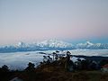
Sandakphu or Sandakfu or Sandakpur is the highest peak in the district of Illam, Nepal. It is the highest point of the Singalila Ridge in Darjeeling district on the West Bengal-Nepal border. The peak is located at the edge of the Singalila National Park and has a small village on the summit with a few hotels. Four of the five highest peaks in the world, Everest, Kangchenjunga, Lhotse and Makalu can be seen from its summit. It also affords a pristine view of the entire Kangchenjunga Range.

The Red Corridor is the region in the eastern, central and the southern parts of India that experience considerable Naxalite–Maoist insurgency.

The following outline is provided as an overview of, and topical guide to, India:

Bijapur District, formerly known as Birjapur, is one of the 27 districts of the state of Chhattisgarh in central India. It is one of the two new districts created on May 11, 2007. As of 2011 it is the second least populous district of Chhattisgarh, after Narayanpur. It is the second-least literate district in India, with a literacy rate of at 41.58%, according to the 2011 census. Madhya Pradesh
Nandvanshi is a term designating the descendants of Nanda. According to the Harivamsha and the Puranas,Nanda was the head of the Gopas, a tribe of cowherds referred as Holy Gwals. Vasudeva took his new-born son Krishna to Nanda on the night of the child's birth so that Nanda could raise him.
Zeliangrong people are one of the major indigenous Naga communities living in the tri-junction of Assam, Manipur and Nagaland in India. They are the descendants of Nguiba. The term "Zeliangrong" refers to the Zeme, Liangmai and Rongmei Naga tribes combined together. Earlier, the term also covered the Inpui tribe. Population wise they are the biggest community among the Nagas. The Zeliangrong worship the Supreme God Haipou Tingkao Ragwang or Tingwang(as known by the Zeme and liangmei) and other sylvan Gods. But most of them got converted to Christianity due to its wave during the 1950s. The descendants of Hoi of Makuilongdi (Makhel) were divided and were made peripheral appendages to three political entities - Manipur, Naga Hills (Nagaland) and the Dima Hasao of Assam. The Zeliangrong may be classified as an ethno-cultural entity. The Zeliangrong belong to the larger Southern Mongoloid population and their language belongs to the Sino-Tibetan family of languages.

Northeast India consists of the eight states Arunachal Pradesh, Assam, Manipur, Meghalaya, Mizoram, Nagaland, Sikkim and Tripura. This article covers tourist attractions in the Northeast region of India.

Bailadila Range, is a mountain range rising in the Deccan Plateau about 200 km west of the Eastern Ghats. It has been named 'Bailadila' because it resembles the hump of an ox. It is located near Kirandul town in the Dantewada district of southern Chhattisgarh, India.
Naina Peak is the highest hill in Nainital district and the southern part of Uttarakhand State in India.
The northwestern portion has the greatest elevation having highest point at Amsot peak (957 m)