Related Research Articles
Baton Rouge is the capital city of the U.S. state of Louisiana. Located on the eastern bank of the Mississippi River, it had a population of 227,470 as of 2020; it is the seat of Louisiana's most populous parish (county-equivalent), East Baton Rouge Parish, and the center of Louisiana's second-largest metropolitan area and city, Greater Baton Rouge.

West Feliciana Parish is a civil parish located in the U.S. state of Louisiana. At the 2020 census, the population was 15,310. The parish seat is St. Francisville. The parish was established in 1824.

St. Helena Parish is a parish in the U.S. state of Louisiana. At the 2020 United States census, the population was 10,920. Its seat is Greensburg. The parish was created in 1810. St. Helena Parish is part of the Baton Rouge metropolitan area.

Iberville Parish is a parish located south of Baton Rouge in the U.S. state of Louisiana, formed in 1807. The parish seat is Plaquemine. The population was 30,241 at the 2020 census.

Lafayette is the most populous city in and parish seat of Lafayette Parish in the U.S. state of Louisiana, located along the Vermilion River. It is Louisiana's fourth-most populous city with a 2020 census population of 121,374; the consolidated city-parish's population was 241,753 in 2020. The Lafayette metropolitan area was Louisiana's third largest metropolitan statistical area with a population of 478,384 at the 2020 census. The Acadiana region containing Lafayette is the largest population and economic corridor between Houston, Texas and New Orleans.

The Chicago metropolitan area, also referred to as the Greater Chicago Area and Chicagoland, is the largest metropolitan statistical area in the U.S. state of Illinois, and the Midwest, containing the City of Chicago along with its surrounding suburbs and satellite cities. Encompassing 10,286 square mi (28,120 km2), the metropolitan area includes the city of Chicago, its suburbs and hinterland, that span 14 counties across northeast Illinois, northwest Indiana, and southeast Wisconsin. The MSA had a 2020 census population of 9,618,502 and the combined statistical area which spans up to 19 counties had a population of nearly 10 million people. The Chicago area is the third largest metropolitan area in the United States and the fourth largest metropolitan area in North America, and the largest in the Great Lakes megalopolis. Its urban area is one of the forty largest in the world.

The New Orleans metropolitan area, designated the New Orleans–Metairie metropolitan statistical area by the U.S. Office of Management and Budget, or simply Greater New Orleans, is a metropolitan statistical area designated by the United States Census Bureau encompassing seven Louisiana parishes—the equivalent of counties in other U.S. states—centered on the city of New Orleans. The population of Greater New Orleans was 1,271,845 in 2020, up from 1,189,166 at the 2010 United States census. Greater New Orleans is the most populous metropolitan area in Louisiana, and the 45th most populous in the United States. According to 2017 census estimates, the broader New Orleans–Metairie–Slidell combined statistical area (CSA) had a population of 1,510,562.

The Portland metropolitan area is a metro area with its core in the U.S. states of Oregon and Washington. It has 5 principal cities the largest being Portland, Oregon. The U.S. Office of Management and Budget (OMB) identifies it as the Portland–Vancouver–Hillsboro, OR–WA Metropolitan Statistical Area, a metropolitan statistical area used by the United States Census Bureau (USCB) and other entities. The OMB defines the area as comprising Clackamas, Columbia, Multnomah, Washington, and Yamhill Counties in Oregon, and Clark and Skamania Counties in Washington. The area had a population of 2,512,859 at the 2020 census, an increase of over 12% since 2010.

The Lynchburg Metropolitan Statistical Area is a United States Metropolitan Statistical Area (MSA) in the state of Virginia, as defined by the Office of Management and Budget (OMB) as of June 2003. As of the 2000 census, the MSA had a population of 228,616. In 2009 this was estimated to have risen to 247,447; as of 2016, the Lynchburg MSA was estimated to have a population of 260,320, making it the fifth-largest metro area in the state.

Caddo Parish is a parish located in the northwestern corner of the U.S. state of Louisiana. According to the 2020 U.S. census, the parish had a population of 237,848. The parish seat is Shreveport, which developed along the Red River.

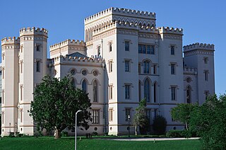
The Baton Rouge metropolitan statistical area, as defined by the United States Office of Management and Budget, or simply the Baton Rouge metropolitan area or Greater Baton Rouge, is a sprawling metropolitan statistical area surrounding the city of Baton Rouge. Including the western edge of the Florida Parishes regions, it is known as "Plantation Country", the "Capital Region", and "The 225". At the 2010 U.S. census, the metropolitan area had a population of 802,484, up from 705,973 in 2000. At the 2020 census, its population increased to 870,569, up from 2020 estimates at 858,571.

The Houma–Bayou Cane–Thibodaux metropolitan area, officially the Houma–Bayou Cane–Thibodaux metropolitan statistical area, is a Metropolitan Statistical Area in the Acadiana region of southern Louisiana, United States that covers two parishes—Lafourche and Terrebonne. The metropolis had a 2020 census-tabulated population of 207,137.

The Shreveport–Bossier City metropolitan area, officially designated Shreveport–Bossier City by the U.S. Office of Management and Budget, or simply Greater Shreveport, is a metropolitan statistical area in northwestern Louisiana that covers three parishes: Caddo, Bossier, and DeSoto. At the 2020 United States census, the metropolitan region had a population of 393,406; its American Community Survey population was 397,590 per census estimates. With a 2010 census population of 439,000, it declined to become Louisiana's fourth largest metropolis at 394,706 residents at the 2019 census estimates.

Lafayette, Vermilionville, or the Lafayette metropolitan statistical area per the U.S. Office of Management and Budget, is the third largest metropolitan statistical area in the U.S. state of Louisiana. Located in the south central Acadiana region, it covers five parishes. At the 2020 U.S. census, 478,384 people lived in the metropolitan area, making it the 116th most populous in the United States and one of Louisiana's fastest growing metropolises; in 2010, its population was 273,738 and it outpaced the Shreveport–Bossier City metropolitan area in 2015.

The Lake Charles metropolitan statistical area is a metropolitan area in the Acadiana region of southwest Louisiana that covers three parishes—Calcasieu, Cameron, and Jefferson Davis. According to a 2023 census estimate, the MSA had a population of 240,082. It is also part of the larger Lake Charles–DeRidder combined statistical area which had a population of 276,909 in 2023. The Lake Charles MSA also shares borders with the Beaumont–Port Arthur metropolitan area to the west. Metropolitan Lake Charles, the principal city, is commonly referred to as the Lake Area.

The Monroe metropolitan area, officially the Monroe metropolitan statistical area, is a metropolitan statistical area in Northern Louisiana that covers three parishes—Ouachita, Union, and Morehouse. According to the 2020 census, the MSA had a population of 207,104.
The Shreveport–Bossier City–Minden combined statistical area is made up of four parishes in northwestern Louisiana. The statistical area consists of the Shreveport–Bossier City metropolitan statistical area and the Minden micropolitan statistical area. As of the 2010 census, the CSA had a population of 439,000. In 2013, OMB changed statistical definitions, subsuming Minden into the Shreveport metro ; in 2018 these changes were reversed.

The Columbus metropolitan area, officially the Columbus metropolitan statistical area, and colloquially known as the Chattahoochee Valley, is a metropolitan statistical area consisting of six counties in the U.S. state of Georgia and one county in Alabama, anchored by the city of Columbus.

The Macon metropolitan area is a metropolitan statistical area consisting of five counties in Central Georgia, anchored by the principal city of Macon. At the 2010 U.S. census, the five-county area had a population of 232,293. A July 2017 estimate placed the population at 228,914. In 2022, its estimated population was 235,805.
References
- ↑ "Table 1. Annual Estimates of the Population for Parishes of Louisiana: April 1, 2000 to July 1, 2009" (CSV). 2008 Population. United States Census Bureau, Population Division. March 23, 2010. Retrieved March 30, 2010.
- ↑ "Census profile: New Orleans-Metairie, LA Metro Area". Census Reporter. Retrieved May 11, 2022.
- ↑ "Census profile: Baton Rouge, LA Metro Area". Census Reporter. Retrieved May 11, 2022.
- ↑ "Census profile: Lafayette, LA Metro Area". Census Reporter. Retrieved May 11, 2022.
- ↑ "Census profile: Shreveport-Bossier City, LA Metro Area". Census Reporter. Retrieved May 11, 2022.
- ↑ "Census profile: Lake Charles, LA Metro Area". Census Reporter. Retrieved May 11, 2022.
- ↑ "Census profile: Houma-Thibodaux, LA Metro Area". Census Reporter. Retrieved May 11, 2022.
- ↑ "Census profile: Monroe, LA Metro Area". Census Reporter. Retrieved May 11, 2022.
- ↑ "Census profile: Alexandria, LA Metro Area". Census Reporter. Retrieved May 11, 2022.
- ↑ "Census profile: Hammond, LA Metro Area". Census Reporter. Retrieved May 11, 2022.