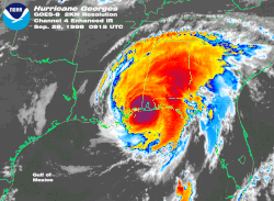
A Mississippi hurricane is a North Atlantic tropical cyclone that affected the U.S. state of Mississippi. From 1851 to the present, 108 tropical cyclones have passed through Mississippi. The costliest and deadliest hurricane in this period was Hurricane Katrina in 2005. Six hurricanes have made landfall as major hurricanes, [nb 1] the strongest of them being Hurricane Camille in 1969.
Month | Number of storms |
---|---|
May | |
June | |
July | |
August | |
September | |
October |
Storm | Date of Landall | Intensity | Landfall Location |
---|---|---|---|
"Great Mobile" | August 26, 1852 | 100 kts | Pascagoula |
"Middle Gulf Shore" | September 16, 1855 | 100 kts | Waveland |
Hurricane Four | August 11, 1860 | 100 kts | Gulfport |
Hurricane Two | July 5, 1916 | 105 kts | Grand Bay, Alabama‡ |
Camille | August 26, 1969 | 150 kts | Waveland |
Frederic | September 13, 1979 | 115 kts† | Bayou la Batre, Alabama‡ |
Elena | September 2, 1985 | 100 kts | Gulfport |
Katrina | August 29, 2005 | 105 kts | Jackson Landing |
†Best track data for storms between 1971 and 1979 does not currently include non-synoptic points to indicate the storm's strength at landfall. The last synoptic point before landfall is used in this case instead. | |||
‡Storm did not make landfall in Mississippi, but brought major hurricane winds to the state. |
The following is a list of tropical cyclones with known deaths in the state.
Name | Year | Number of Deaths | Notes |
---|---|---|---|
Katrina | 2005 | 238+ | [28] |
Camille | 1969 | 137 | [38] |
"Cheniere Caminada" | 1893 | 130 | [7] |
"1906 Mississippi" | 1906 | 78 | [39] |
Unnamed | 1821 | 35 | [2] |
"Fort Lauderdale" | 1947 | 22 | [12] |
"Great Mobile" | 1852 | 4+ | [3] |
"1934 Central America" | 1934 | 4 | [11] |
Isidore | 2002 | 3 | [40] |
Isaac | 2012 | 2 | [41] |
Ida | 2021 | 2 | [36] |
Audrey | 1957 | 1 | [42] |
Betsy | 1965 | 1 | [17] |
Debra | 1978 | 1 | [20] |
Allison | 2001 | 1 | [13] |
Lee | 2011 | 1 | [43] |
Zeta | 2020 | 1 | [34] |
The 2002 Atlantic hurricane season was a near-average Atlantic hurricane season. It officially started on June 1, 2002, and ended on November 30, dates which conventionally limit the period of each year when most tropical cyclones develop in the Atlantic Ocean. The season produced fourteen tropical cyclones, of which twelve developed into named storms; four became hurricanes, and two attained major hurricane status. While the season's first cyclone did not develop until July 14, activity quickly picked up: eight storms developed in the month of September. It ended early however, with no tropical storms forming after October 6—a rare occurrence caused partly by El Niño conditions. The most intense hurricane of the season was Hurricane Isidore with a minimum central pressure of 934 mbar, although Hurricane Lili attained higher winds and peaked at Category 4 whereas Isidore only reached Category 3. However, Lili had a minimum central pressure of 938 mbar.
The 1959 Atlantic hurricane season featured near normal tropical cyclone activity overall. The season officially began on June 15, 1959 and lasted until November 15, 1959. These dates historically described the period in each year when most tropical cyclogenesis occurs in the Atlantic basin. However, the formation of a tropical cyclone is possible at any time of the year, as shown in 1959, by the formation of Tropical Storm Arlene on May 28. Arlene struck Louisiana and brought minor flooding to the Gulf Coast of the United States. The next tropical storm, Beulah, formed in the western Gulf of Mexico and brought negligible impact to Mexico and Texas. Later in June, an unnamed hurricane, caused minor damage in Florida, and then devastated parts of Maritime Canada, resulting in what became known as the Escuminac disaster. Hurricane Cindy brought minor impact to The Carolinas. In late July, Hurricane Debra produced flooding in the state of Texas. Tropical Storm Edith in August and Hurricane Flora in September caused negligible impact on land.
The 1960 Atlantic hurricane season was the least active season since 1952. The season officially began on June 15, and lasted until November 15. These dates conventionally delimit the period of each year when most tropical cyclones form in the Atlantic basin. The first system, an unnamed storm, developed in the Bay of Campeche on June 22. It brought severe local flooding to southeastern Texas and was considered the worst disaster in some towns since a Hurricane in 1945. The unnamed storm moved across the United States for almost a week before dissipating on June 29. In July, Hurricane Abby resulted in minor damage in the Leeward Islands, before impacting a few Central American counties — the remnants of the storm would go on to form Hurricane Celeste in the East Pacific. Later that month, Tropical Storm Brenda caused flooding across much of the East Coast of the United States. The next storm, Hurricane Cleo, caused no known impact, despite its close proximity to land.
The 1969 Atlantic hurricane season was the most active Atlantic hurricane season since the 1933 season, and was the final year of the most recent positive Atlantic multidecadal oscillation (AMO) era. The hurricane season officially began on June 1, and lasted until November 30. Altogether, 12 tropical cyclones reached hurricane strength, the highest number on record at the time; a mark not surpassed until 2005. The season was above-average despite an El Niño, which typically suppresses activity in the Atlantic Ocean, while increasing tropical cyclone activity in the Pacific Ocean. Activity began with a tropical depression that caused extensive flooding in Cuba and Jamaica in early June. On July 25, Tropical Storm Anna developed, the first named storm of the season. Later in the season, Tropical Depression Twenty-Nine caused severe local flooding in the Florida Panhandle and southwestern Georgia in September.
The 1977 Atlantic hurricane season was a very inactive Atlantic hurricane season, with only six named storms. The season officially began on Wednesday, June 1, 1977 and lasted until Wednesday, November 30, 1977. These dates conventionally delimit the period of each year when most tropical cyclogenesis occurs in the Atlantic basin. The first tropical cyclone of the season developed over the western Caribbean Sea on June 13, 12 days after the start of the season. Three more organized during July and early August. Then, on August 29, the first named storm, Hurricane Anita formed and rapidly intensified to a Category 5 hurricane on September 1, before weakening slightly and striking Mexico as a high-end Category 4 hurricane on the Saffir–Simpson hurricane wind scale, bringing strong winds and heavy rainfall, causing 11 fatalities and leaving at least 25,000 people homeless.
The 1979 Atlantic hurricane season was the first Atlantic hurricane season to include both male and female names on its list of tropical cyclone names. The season officially began on June 1, and lasted until November 30. These dates conventionally delimit the period of each year when most tropical cyclones form in the Atlantic basin. It was slightly below average, with nine systems reaching tropical storm intensity. The first system, an unnumbered tropical depression, developed north of Puerto Rico on June 9. Two days later, Tropical Depression One formed and produced severe flooding in Jamaica, with 40 deaths and about $27 million (1979 USD) in damage. Tropical Storm Ana caused minimal impact in the Lesser Antilles. Hurricane Bob spawned tornadoes and produced minor wind damage along the Gulf Coast of the United States, primarily in Louisiana, while the remnants caused flooding, especially in Indiana. Tropical Storm Claudette caused extensive flooding in Texas due to torrential rainfall, resulting in two deaths and about $750 million in damage.
The 1985 Atlantic hurricane season had six United States landfalling hurricanes, tied with 1886 and 2020 for the highest number on record. The season officially began on June 1 and lasted until November 30. It was an average season, with 11 named storms developing. This was partially attributed to a La Niña – a meteorological phenomenon that produces favorable conditions across the Atlantic basin, such as lower wind shear and higher sea surface temperatures. The first storm, Ana, developed on July 15 near Bermuda and caused minor effects in Canada while transitioning into an extratropical cyclone. Three other tropical cyclones – Claudette, Henri, and Isabel – did not significantly affect land. Claudette developed offshore of the Southeastern United States and brushed Bermuda and the Azores. Henri and Isabel were dissipating as they approached land. However, the precursor of the latter caused a severe flood in Puerto Rico that killed 180 people. Additionally, Tropical Storm Fabian and three tropical depressions did not have any known impact on land.
Hurricane Isidore was a powerful tropical cyclone that caused widespread flooding and heavy damage across Mexico, Cuba, and the United States in September 2002. The ninth named storm and the second hurricane in the 2002 Atlantic hurricane season, and the fifth of eight named storms to occur in September of that year, Isidore peaked as a Category 3 hurricane, causing damage, as well as four fatalities in Jamaica, Cuba, Mexico, and the United States. Isidore is also noted for threatening to strike the northern Gulf Coast as a Category 4 hurricane, however, the storm struck the region as a moderately-strong tropical storm, due to a track change that brought the storm over the Yucatán Peninsula for over a day, which significantly weakened the cyclone in the process. The primary impact from the storm was the heavy rainfall, which fell across southeast Mexico, and also from the central United States Gulf coast into the Ohio Valley.
The 1949 Atlantic hurricane season was the last season that tropical cyclones were not publicly labeled by the United States Weather Bureau. It officially began on June 15, and lasted until November 15. These dates conventionally delimit the period of each year when most tropical cyclones form in the Atlantic basin. The first storm, a tropical depression, developed in the northern Gulf of Mexico on August 14. The final system, Tropical Storm Sixteen, dissipated in the southwestern Caribbean Sea on November 5. It was a fairly active season, featuring 16 tropical storms and seven hurricanes. Two of these strengthened into major hurricanes, which are Category 3 or higher on the Saffir–Simpson hurricane wind scale.
The 1948 Atlantic hurricane season featured the first tropical cyclone before the month of June since 1940. The season officially began on June 15, 1948, and lasted until November 15, 1948. These dates conventionally delimit the period of each year when most tropical cyclones form in the Atlantic basin. There were fifteen tropical cyclones; ten systems strengthened into a tropical storm, six storms attained hurricane status, and four storms intensified into major hurricanes, which are Category 3 or higher on the modern-day Saffir–Simpson hurricane wind scale. Operationally, it was believed that a weak tropical disturbance formed over the southeast Bahamas in May and moved northwest into the Georgia coast near Savannah. This system was later excluded from HURDAT. The seventh tropical cyclone was not operationally considered a tropical cyclone, but was later added to HURDAT.
Hurricane Edith was the strongest hurricane to form during the 1971 Atlantic hurricane season and the southernmost landfalling Category 5 hurricane on record in the Atlantic at the time. Edith developed from a tropical wave on September 5 and quickly strengthened into a hurricane in the Caribbean Sea. Edith rapidly intensified on September 9 and made landfall on Cape Gracias a Dios as a Category 5 hurricane on the Saffir-Simpson Hurricane Scale. Being a category 5 hurricane, Edith peaked at only 943 mbar (hPa), making Edith the least intense category 5 Atlantic hurricane on record. It quickly lost intensity over Central America and after briefly entering the Gulf of Honduras it crossed the Yucatán Peninsula in Mexico. After moving across the Gulf of Mexico a trough turned the storm to the northeast and Edith, after having restrengthened while accelerating towards the coast, made landfall on Louisiana with winds of 105 mph (169 km/h) on September 16. Edith steadily weakened over land and dissipated over Georgia on September 18.
The 1901 Atlantic hurricane season was the most active season without a major hurricane – tropical cyclones that reach at least Category 3 on the Saffir–Simpson hurricane wind scale – until 2013. The first system was initially observed in the northeastern Caribbean on June 11. The fourteenth and final system transitioned into an extratropical cyclone near Bermuda on November 5. These dates fall within the period with the most tropical cyclone activity in the Atlantic. Eight of the fourteen tropical cyclones existed simultaneously.
Tropical Storm Matthew was a weak tropical storm in the 2004 Atlantic hurricane season that made landfall on Louisiana. It was the thirteenth tropical storm of the season and the ninth to affect the United States. It formed over the western Gulf of Mexico on October 8 and struck south-central Louisiana two days later. The combination of the storm and an upper cyclone over the southern Plains brought heavy rains to much of the Gulf Coast, with the highest amounts reported over 15 inches (380 mm) in northern Louisiana. Damage was minimal, totaling $305,000 (2004 USD), and no casualties were reported.
Tropical Storm Bertha was a minimal tropical storm that made landfall twice along the Gulf Coast of the United States in August 2002. The second tropical storm of the 2002 Atlantic hurricane season, Bertha developed in the northern Gulf of Mexico out of a trough of low pressure that extended into the Atlantic on August 4. It quickly organized and reached tropical storm strength before making landfall on southeastern Louisiana. Bertha turned to the southwest over the state, and re-entered the Gulf of Mexico on August 7. It remained disorganized due to proximity to land, and after making landfall on south Texas, Bertha dissipated on August 9.
Hurricane Fern was the sixth named storm and fourth hurricane of the 1971 Atlantic hurricane season. It formed from a tropical wave which interacted with a large trough of low pressure to form Fern, as well as Hurricane Ginger, Tropical Storm Heidi, and a system later designated as Tropical Depression Sixteen, which moved into South Carolina. Fern crossed southeastern Louisiana as a tropical depression on September 4 before swinging back out over the Gulf of Mexico. Fern reached hurricane status on September 8, reaching a peak intensity of 90 mph (140 km/h) before making landfall near Freeport, Texas, two days later.
Hurricane Humberto was a Category 1 hurricane that formed and intensified faster than any other North Atlantic tropical cyclone on record, before landfall. The eighth named storm and third hurricane of the 2007 Atlantic hurricane season, Humberto developed on September 12, 2007, in the northwestern Gulf of Mexico. The tropical cyclone rapidly strengthened and struck High Island, Texas, with winds of about 90 mph (140 km/h) early on September 13. It steadily weakened after moving ashore, and on September 14, Humberto began dissipating over northwestern Georgia as it interacted with an approaching cold front.
{{cite report}}
: CS1 maint: url-status (link)