Tropical storm (39–73 mph, 63–118 km/h)
Category 1 (74–95 mph, 119–153 km/h)
Category 2 (96–110 mph, 154–177 km/h)
Category 3 (111–129 mph, 178–208 km/h)
Category 4 (130–156 mph, 209–251 km/h)
Category 5 (≥157 mph, ≥252 km/h)
Unknown
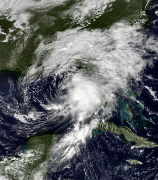
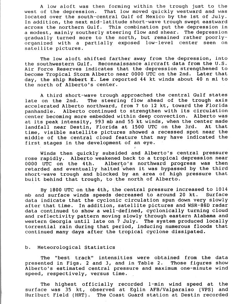
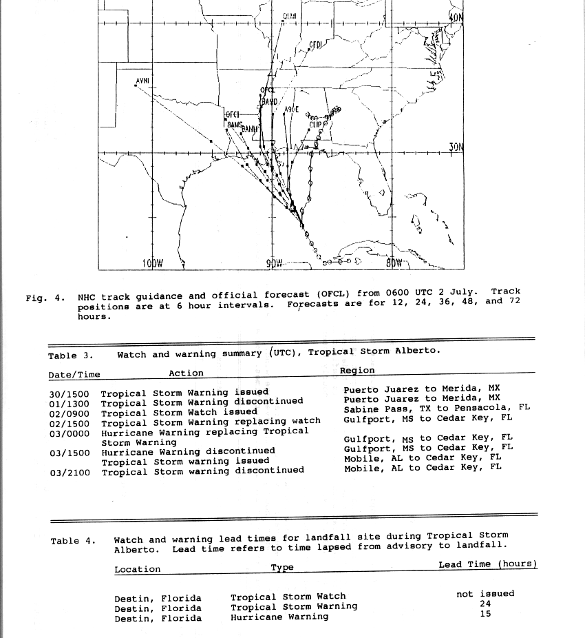
Radiosonde data from Dakar, Senegal, indicated that a tropical wave emerged into the Atlantic from the west coast of Africa on June 18. The wave moved westward for several days, with an associated area of low clouds. Little deep convection developed until June 26, when the wave was situated in just north of Puerto Rico and the Virgin Islands. However, strong wind shear diminished a significant amount of convection while the system crossed the Bahamas on June 28. After crossing Cuba and emerging into the Caribbean Sea by the following day, deep convection quickly redeveloped and became more concentrated as the wave encountered only light vertical wind shear. A reconnaissance aircraft flight into the system on June 30 detected a well-defined circulation. As a result, Tropical Depression One developed just west of Isla de la Juventud at 06:00 UTC. Initially, the depression moved westward at about 8 mph (13 km/h). [1] However, a low aloft centered over the south-central Gulf of Mexico and a mid-latitude short-wave trough moving eastward across the northern gulf caused the depression to curve northwestward on July 1. [2]
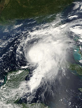
Early on July 2, a reconnaissance aircraft flight into the cyclone indicated that it had intensified into a tropical storm, which was assigned the name Alberto. Later that day, Alberto accelerated somewhat in a northerly direction due to another short-wave trough approaching the central Gulf Coast of the United States, with the storm's forward speed increasing to about 14 mph (23 km/h). Although the system previously had a rather poor appearance on satellite imagery, the center of circulation became more embedded within the deep convection. At 12:00 UTC on July 3, Alberto attained its peak intensity with maximum sustained winds of 65 mph (100 km/h) and a minimum barometric pressure of 993 mbar (29.3 inHg ). [2] About three hours later, the cyclone made landfall near Destin, Florida, at the same intensity. As the storm moved inland, satellite imagery detected hints of a developing eye feature. However, Alberto rapidly weakened, falling to tropical depression intensity by 00:00 UTC on July 4. After bypassing the short-wave trough, the cyclone's forward progress became blocked by a building high pressure area. As a result, Alberto began drifting over Georgia, executing a small cyclonic loop before entering Alabama. Although very weak, the depression remained a tropical cyclone until its circulation dissipated over Alabama late on July 7. [2]
Preparations
On June 30, on the day of Alberto's formation, a tropical storm warning was issued from Puerto Juárez to Mérida, Mexico; the warning was discontinued on July 1. In the United States, a tropical storm watch was posted on July 2 for locations between Sabine Pass, Texas and Pensacola, Florida. The watch was subsequently upgraded to a tropical storm warning from Gulfport, Mississippi, to Cedar Key, Florida; it was soon altered to a hurricane warning. Later on July 3, the hurricane warning was discontinued and replaced with a tropical storm warning, which was lifted at 2100 UTC. [3]
On the Florida Panhandle, residents boarded up windows in anticipation of what was to be a "fury". [4] At gasoline stations, unusually long lines formed, and local stores did increased business in selling emergency supplies. [5] Thousands of tourists along the coast left the region; a local deputy was quoted as estimating that 10,000 people checked out of their hotels early. On Okaloosa Island and Holiday Isle, ground-floor house and businesses were forced to evacuate. [6] Civil-defense authorities evacuated residents from low-lying locations. [7] Then-Governor of Florida, Lawton Chiles, declared a State of emergency for parts of the state, and advised residents along the coast to monitor updates regarding the storm. [8] Over 3,000 people sought refuge in Red Cross shelters along the coast of Florida, westward into parts of Alabama. [9]
Impact

Upon forming, the storm dropped heavy rainfall over parts of Cuba, peaking at 10 inches (250 mm). [10] [11]
In the United States, Alberto produced heavy rainfall over the Florida Panhandle, southeastern Alabama, and central and southwest Georgia. Within the three states combined, floodwaters impacted more than 900,000 acres (360,000 ha ) of crops. The storm damaged or destroyed approximately 18,000 homes and damaged more than 1,000 roads and 218 dams, many of which failed. Flooding also prompted about 50,000 people to flee their homes. [12] Throughout the United States, Alberto caused about $1.03 billion in damage. [13] A total of 33 deaths occurred, 31 in Georgia and 2 in Alabama. [12]
Florida
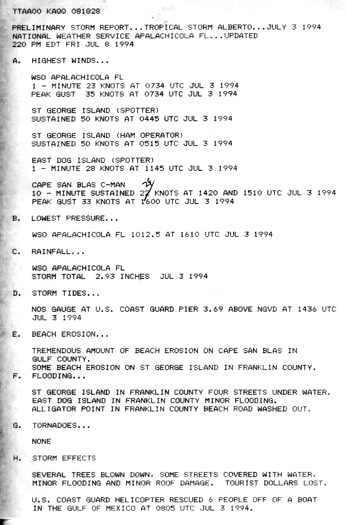
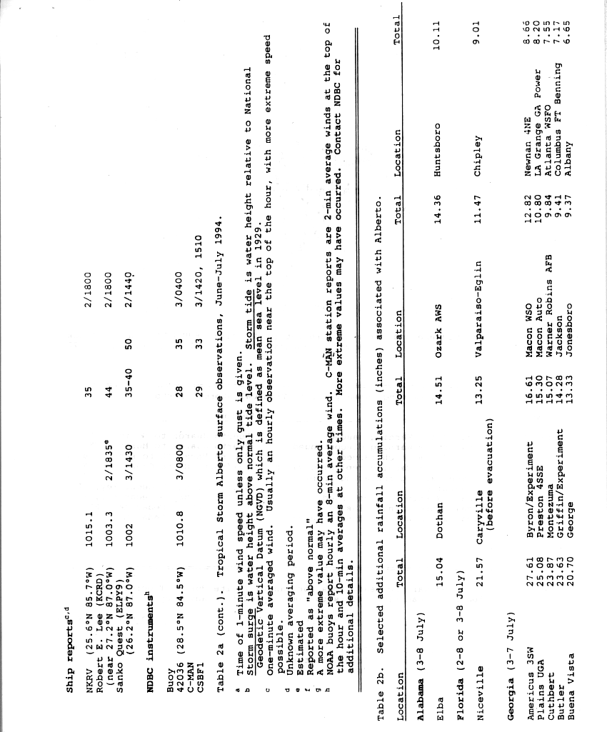
At Destin, Florida, sustained winds blew at 63 mph (101 km/h), [14] : 38 while winds gusted to 75 mph (121 km/h); however, there was an unofficial report of 89 mph (143 km/h) gusts. There, barometric pressure fell to 993 mbar (29.3 inHg) in association with Alberto. Storm tides of 5 ft (1.5 m) was estimated along the coast of Destin, while tides reached 3 ft (0.91 m) at Panama City. [10] At St. George Island, wind gusts reached 58 mph (93 km/h). Beach erosion and tidal flooding occurred along the coast. [15] Throughout northwest Florida, 5 in (130 mm) of rain fell, [10] with totals as high as 21.57 in (548 mm). Other precipitation accumulations include 13.25 in (337 mm) at Caryville. [16]
Along the coast, damage was limited to sea walls, piers and boats, and roof damage to some beachfront motels. As the storm progressed inland, it brought down signs, billboards, trees and powerlines, and triggered moderate flooding; about 18,500 customers lost electric power. As a weakened tropical depression, the remnants of Alberto dropped extensive rainfall throughout the region. [14] : 38 As heavy rain fell to the north, tremendous volumes of water moved down major river systems into the Florida Panhandle. [12] As a result, there was extensive river flooding that exceeded 100-year events in some locations, particularly along the Apalachicola and Chipola Rivers. The Apalachicola remained above flood stage until August, although in localized areas, flooding persisted until September due to Tropical Storm Beryl. A total of 300,000 chickens and 125 cattle and hogs were lost within the state, and offshore, 90% of the oysters in Apalachicola Bay were lost. The flooding was severe, inflicting $40 million (1994 USD) in damage to infrastructure, $14 million in insured damage, and $25 million in agricultural losses. [14] : 38
Georgia

In Georgia, rainfall from the tropical cyclone peaked at 27.85 in (707 mm) near Americus. [17] Due to a previously stalled cold front, which subsequently caused Alberto to remain stationary, the ground was already saturated with rainfall. Virtually all of the precipitation became instant runoff into streams and rivers. [14] Peak discharges along the Flint and Ocmulgee rivers exceeded 100-year flood levels. [18] At least 100 dams and recreational watersheds suffered severe damage or were destroyed. Many roads were inundated, forcing the closure of 175 roads and 1,000 bridges. [18] [19] Damage to highway infrastructure exceeded $130 million. [18]
Approximately 471,000 acres (191,000 ha) of croplands were submerged, causing about $100 million in damage to agriculture. Fifteen of the United States Geological Survey's (USGS) gaging stations were severely damaged or demolished, forcing data to be collected manually and reported by cellphone. Due to flooded water systems, approximately 500,000 people were temporarily left without drinking water. There were 31 deaths in the state, [18] most of which from cars being swept onto flooded roads or into swollen creeks. [19] With $750 million in damage, Alberto was considered the costliest tropical cyclone in Georgia, [20] until Hurricane Michael in 2018. [21] The flooding was considered the worst in the history of the state. [22]
Southwest Georgia
Along the state line with Florida, five counties in southwestern Georgia reported 3 to 5 in (76 to 127 mm) of precipitation. In Bainbridge, the rising Flint River caused 300 residents to evacuate. [14] Although the river crested about 7 ft (2.1 m) lower than initially predicted, flooding moderately or severely damaged approximately 300 homes in Bainbridge, as well as more than a dozen businesses. [23] A local fertilizer plant was also threatened by the swollen Flint River. In the five counties of Brooks, Colquitt, Cook, Thomas, and Worth, the Little and Ochlockonee rivers overflowed their banks, flooding adjacent areas. In Early and Miller counties, 7 to 10 in (180 to 250 mm) of rain fell between July 3 and July 7, while an additional 3 to 7 in (76 to 178 mm) of precipitation was observed from July 10 to July 14. Many low-lying areas were flooded. Seven families were evacuated from their homes in Safford due to flooding. Further north, the Flint River also overflow its banks in Baker and Mitchell counties. Extensive flooding occurred in Newton, with more than $100,000 in property damage. Widespread inundation of crops were reported in both counties. [14]
In Dougherty County, the Flint River exceeded its banks, forcing over 20,000 residents to evacuate. Five deaths were reported in the county, with four people drowning in the river and another from a woman being trapped in her home for several days. The city of Albany was cut in half by the flooding, and hundreds of caskets were disinterred and floated away, sometimes disintegrating into the water. [24] Several locations along State Route 37 flooded in Fort Gaines, a city in Clay County.To the north in Randolph County, Cuthbert recorded 23.85 in (606 mm) of rainfall during a 5-day period. Many streets in the city were flooded, including two portions of U.S. Route 82 and a part of State Route 266. In Terrell County, the sheriff's department reported that many roads were inundated due to swollen creeks and streams. A number of homes and businesses were suffered extensive impact, with up to several million dollars in many. A woman died in Dawson after her car was swept off the road into Chickasawhatchee River. [14]
Numerous county roads were flooded in Lee County due to swollen streams and creeks. Over 600 people were evacuated from their homes county-wide after rising waters began to flood residential areas. In Webster County, many roads were inundated due to the flooding of streams and creeks. About 1 to 5 in (25 to 127 mm) of precipitation fell in Dodge, Pulaski, Wilcox counties, inundating croplands along the Ocmulgee River. Extensive flooding was reported in much of Dooly County. Several bridges washed out and many roads were closed, including State Route 27 near Drayton. Some residential areas were flooded, resulting in evacuations. In Crisp County, a portion of Interstate 75 was closed due to flooding. A subdivision was evacuated, as well as areas around Lake Blackshear. [14]
In Americus, flood waters threatened 21,000 acres (8,500 ha) of peanuts and other crops such as cotton and corn, while numerous streets, businesses, and homes were inundated. Nine people died after cars washed off of inundated roads. Two other fatalities occurred after flood waters destroyed a home on Lake Jackson and another after a mobile home was swept away. In Plains, 22.8 inches (580 mm) of rainfall was observed. Several homes and businesses were inundated. A tractor trailer on U.S. Route 280 washed away, killing the three male occupants of the vehicle. [14] Additionally, flood waters approached the home of former President of the United States Jimmy Carter, but no damage occurred. [25] Standing water also covered numerous roads in Leslie. On Lake Corinth, a 17‑year‑old boy attempted to fix a downed telephone line, but died after his boat capsized. [14]
Central Georgia
For a time, the city of Macon was completely cut off by flood waters severing all roads in and out of the city. Most of the city lost all water service during the height of flood when two major treatment plants were flooded. It took almost three weeks before service was restored. The city of Montezuma was the hardest hit of all when the flood levee was topped by the nearby Flint River. The entire downtown area was inundated with up to 18 feet of water. Cleanup would take months to complete. [14]
In Columbus, 3.5 in (89 mm) of precipitation was observed in 24 hours, while 5.72 in (145 mm) of rain fell throughout a 4-day period. Police reported that numerous streets were flooded, including a cave-in caused by runoff. Three homes in West Point were evacuated. [14]
Several people in Taylor County reported seeing a funnel cloud. Thunderstorm winds damaged some buildings and mobile homes. One woman suffered minor injuries. [14]
North Georgia and Atlanta metropolitan area
Flooding also occurred in portions of the Atlanta metropolitan area. In Heard County, the city of Franklin recorded 6.13 in (156 mm) of precipitation. Portions of State Route 34 were inundated with up to 2 ft (0.61 m) of water. To the east in Coweta County, 6 to 8 in (150 to 200 mm) of rain fell. Two mobile home parks were flooded. Water also inundated Interstate 85 at exit 11. The storm also dropped heavy precipitation in Meriwether County, including 2 in (51 mm) of rain in less than an hour. The resultant flash flood forced the evacuation of two homes and the closure of seven roads, while one bridge was washed out. A thunderstorm in Pike County on July 4 generated wind gusts exceeding 55 mph (89 km/h), downing a number of trees and power lines and damaging homes and historical buildings in Zebulon. A thunderstorm on the following day produced downburst winds, which damaged a few office buildings, ripped off portions of a church roof, and downed more trees in the city. In Spalding County, 14.30 in (363 mm) of precipitation was observed at Griffin. Many homes and businesses were flooded and several earthen dams failed. A woman died when her car ran into a washed out road; two others were injured in the same location. [14]
About 9–13 in (230–330 mm) of rain fell in Butts County. Several roads were inundated by flood waters and a number of culverts and drainage systems that collapsed due to excessive water; a total of 20 roads were closed. Seventy to eighty families in the county were evacuated. At Indian Springs State Park, water overflowed the dams, flooding the park with up to 3 ft (0.91 m) of water. [14] In Henry County, flooding resulted in the closure of about forty roads – including Interstate 75 from Jodeco Road to State Route 20 – with only five or six reopened by a week after the storm began impacting the area. Damage to roads and bridges in the county totaled approximately $500,000. An estimated 25% of crops across Henry County sustained damage, with about 10,000 acres (4,000 ha) of farmlands inundated with water. Additionally, the water authority suffered about $1.2 million in damage. [26] Two deaths occurred in Henry County, both from separate drowning incidents in the Towaliga River. [14]
In Clayton County, rising waterways forced the evacuation of nearly 500 people in the Jonesboro area, [14] including about 200 people at an apartment complex along Sullivan Creek, a tributary of the Flint River. The creek overflowed its banks by roughly 8 ft (2.4 m), with water entering 75 first-floor apartments. [27] Numerous other dwellings in the county were destroyed. [14] Flooding resulted in the closure of seven roads and the collapse of several bridges. Damage to roads and bridges in the county reached approximately $250,000. The water plant suffered about $900,000 in damage, [26] causing it to be shut down. Rainfall totals between 4 and 7 in (100 and 180 mm) flooded numerous culverts, houses, and roads in Rockdale County. Additionally, a 16‑year‑old girl drowned after attempting to rescue a dog. At the Hartsfield–Jackson Atlanta International Airport in Atlanta, 7.05 in (179 mm) of rain was recorded, forcing many to evacuate flooded apartments in nearby College Park. [14] Another person died in a DeKalb County due to a car accident caused by slick roads. [28]
Alabama
Coastal Alabama experienced only minor impacts due to Alberto. The region only recorded wind gusts up to 33 mph (53 km/h) at Dauphin Island, while the National Weather Service office in Mobile noted "the western most rainshield and banded convection associated with T.S. Alberto remained just to the east". [29] To the northeast, however, the cyclone dropped heavy precipitation across the southeastern part of the state, peaking at 22.63 in (575 mm) of rain near Enterprise. [30] Consequently, extensive flooding occurred along waterways such as the Catoma Creek, Choctawhatchee River, Conecuh River, Murder Creek, Pea River, Tallapoosa River. Drainage systems, bridges, and roadways, especially sustained significant impacts, with many road closures in southern Alabama. Two deaths were reported in Alabama, both due to indirect causes, one in Geneva County and the other in Houston County. [14] : 15
In Covington and Houston counties, high winds caused some structural damage and downed many trees. Heavy rains in the latter damaged approximately 185 homes and destroyed numerous mobile homes, while sweeping away or damaging 20 bridges. At least 319 homes were impacted by flooding in Geneva County, more than 100 demolished and 79 substantially damaged. More than 2,500 people fled their homes. In Coffee County, 200-300 residences suffered water damage, while 3,000-4,000 people evacuated due to flooding. Dale County reported the destruction 20 homes, major damage to 20 others, and minor damage to 25 homes. Additionally, the storm demolished approximately 100 mobile homes and damaged around 100 others. In Henry County, roughly 100 homes sustained water damage. [14] : 16–17
Aftermath
Because of the severe flooding in the state of Georgia, then-governor Zell Miller declared 55 counties in a state of emergency, which included the following counties in central Georgia: Bibb, Butts, Crawford, Dooly, Houston, Jones, Lamar, Macon, Monroe, Peach, Sumter, Taylor, Twiggs, and Upson. [31]
Despite the extensive damage and loss of life caused by the storm, the name Alberto was not retired and was used again in the 2000 season.
See also
Related Research Articles

Hurricane Agnes was the costliest hurricane to hit the United States at the time, causing an estimated $2.1 billion in damage. The hurricane's death toll was 128. The effects of Agnes were widespread, from the Caribbean to Canada, with much of the east coast of the United States affected. Damage was heaviest in Pennsylvania, where Agnes was the state's wettest tropical cyclone. Due to the significant effects, the name Agnes was retired in the spring of 1973.

Hurricane Dora was the first tropical cyclone on record to make landfall over the Atlantic coast of North Florida at hurricane intensity. The sixth tropical storm and second hurricane of the 1964 season, Dora developed from a tropical wave near the coast of Senegal on August 28. The depression intensified into Tropical Storm Dora late on August 31. It then curved northeastward and continued to strengthen. By late on September 2, Dora became a Category 1 hurricane. Intensification slowed somewhat, with Dora becoming a Category 2 hurricane on September 4 and then a Category 3 hurricane on next day. Deepening further, the storm briefly peaked as a Category 4 with maximum sustained winds of 130 mph (215 km/h) on September 6. Dora soon weakened to a Category 3 hurricane and then a Category 2 hurricane while curving westward early the following day.

Hurricane Hilda was an intense tropical cyclone that ravaged areas of the United States Gulf Coast, particularly Louisiana. In addition to its damage inland, the hurricane greatly disrupted offshore oil production, and at its time was the costliest tropical cyclone for Louisiana's offshore oil production. Due in part to flights made by the National Hurricane Research Laboratory, Hilda became one of the most well-documented storms meteorologically in the Atlantic. Lasting for seven days as a tropical cyclone, Hilda caused US$126 million in damage and 38 deaths. It was the tenth named storm, sixth hurricane, and the fourth major hurricane of the 1964 Atlantic hurricane season.

Hurricane Bertha was an intense and early-forming major hurricane that affected areas from the Leeward Islands to the United States in July of the 1996 Atlantic hurricane season. The second named storm, first hurricane, and first major hurricane during the season, Bertha originated from a tropical wave that moved off the coast of Africa in early July. Steadily organizing while moving generally towards the west, the disturbance was designated as a tropical depression at 0000 UTC on July 5, and was further upgraded to a tropical storm by 1200 UTC later that day. Over the next few days, continued intensification occurred, and Bertha became a Category 1 hurricane on the Saffir-Simpson hurricane scale, the first hurricane of the season, prior to moving through the northern Leeward Islands. Late on July 8, a period of rapid intensification began, and at 0600 UTC on July 9, Bertha reached its peak intensity with maximum sustained winds of 115 mph (185 km/h) with a minimum barometric pressure of 960 mbar (28 inHg). Moving around the western periphery of the subtropical ridge, Bertha passed north of the Bahamas as a weakening hurricane before turning towards the north-northeast and undergoing another period of rapid intensification. Late on July 12, Bertha made landfall between Wrightsville Beach and Topsail Beach, North Carolina with winds of 105 mph (169 km/h). Gradual weakening ensued the following day as Bertha moved up the Mid-Atlantic and into New England before becoming an extratropical cyclone on July 14. The storm's remnants persisted for another several days, before dissipating on July 18.
Hurricane Gordon caused minor damage in the Eastern United States. The seventh named storm and fourth hurricane of the 2000 Atlantic hurricane season, Gordon developed in the extreme western Caribbean Sea from a tropical wave on September 14. Shortly thereafter, the depression moved inland over the Yucatán Peninsula and later emerged into the Gulf of Mexico on September 15. The depression began to quickly organize, and by early on September 16, it was upgraded to Tropical Storm Gordon. After becoming a tropical storm, Gordon continued to intensify and was reclassified as a hurricane about 24 hours later; eventually, the storm peaked as an 80 mph (130 km/h) Category 1 hurricane. However, southwesterly upper-level winds caused Gordon to weaken as it approached land, and it was downgraded to a tropical storm by late on September 17. At 0300 UTC on September 18, Gordon made landfall near Cedar Key, Florida as a strong tropical storm. After moving inland, Gordon rapidly weakened and had deteriorated to tropical depression status by nine hours later. Later that day, Gordon merged with a frontal boundary while centered over Georgia.

Tropical Storm Hanna was a moderately strong tropical storm that affected the Gulf Coast and Southeastern regions of the United States. The ninth tropical cyclone and eighth named storm of the 2002 Atlantic hurricane season, Hanna formed through the complex interaction of a surface trough, a tropical wave, and an upper-level low pressure system, a disturbance in the upper atmosphere. Designated a tropical depression at 0000 UTC on September 12, the storm remained disorganized throughout its duration, though it attained tropical storm status and a peak intensity of 1,001 mbar (29.6 inHg), with winds of 60 miles per hour (100 km/h). Hanna crossed extreme southeastern Louisiana, and made a second landfall along the Alabama–Mississippi border.

Tropical Storm Bill was a tropical storm that affected the Gulf Coast of the United States in the summer of 2003. The second storm of the 2003 Atlantic hurricane season, Bill developed from a tropical wave on June 29 to the north of the Yucatán Peninsula. It slowly organized as it moved northward, and reached a peak of 60 miles per hour (97 km/h) shortly before making landfall in south-central Louisiana. Bill quickly weakened over land, and as it accelerated to the northeast, moisture from the storm, combined with cold air from an approaching cold front, produced an outbreak of 34 tornadoes. Bill became extratropical on July 2, and was absorbed by the cold front later that day.

Tropical Storm Barry was a strong tropical storm that made landfall on the Florida Panhandle during August 2001. The third tropical cyclone and second named storm of the 2001 Atlantic hurricane season, Barry developed from a tropical wave that moved off the coast of Africa on July 24. The wave entered the Caribbean on July 29 and spawned a low-pressure area, which organized into Tropical Storm Barry on August 3. After fluctuations in intensity and track, the storm attained peak winds of 70 mph (110 km/h) over the Gulf of Mexico. Barry headed northward and moved ashore along the Gulf Coast before degenerating into a remnant low on August 7. On the next day, Barry's remnants dissipated over Missouri.

Tropical Storm Alberto was the first tropical storm of the 2006 Atlantic hurricane season. Forming on June 10 in the northwestern Caribbean, the storm moved generally to the north, reaching a maximum intensity of 70 mph (110 km/h) before weakening and moving ashore in the Big Bend area of Florida on June 13. Alberto then moved through eastern Georgia, North Carolina, and Virginia as a tropical depression before becoming extratropical on June 14.

Tropical Storm Beryl caused flooding in several states in the Eastern United States in August 1994. The second named storm and third tropical cyclone of the annual hurricane season, Beryl developed from an upper-level low pressure area over the northeastern Gulf of Mexico on August 14. Initially a tropical depression, the system intensified into a tropical storm about 24 hours after forming. Beryl then moved slowly northeastward and peaked with maximum sustained winds of 60 mph (95 km/h) before making landfall near Panama City, Florida, early on August 16. Within 12 hours of moving inland, the storm weakened to a tropical depression, but persisted as a tropical cyclone for a few days while traversing the Eastern United States. Beryl was absorbed by a frontal system while situated over Connecticut early on August 19.
Tropical Storm Harvey was a moderately strong tropical storm that caused flooding across south Florida during the 1999 Atlantic hurricane season. The tenth tropical cyclone and eighth named storm of the season, Harvey developed from a tropical wave in the Gulf of Mexico on September 19. After forming, the system gradually intensified and became a tropical storm early on September 20. Throughout the rest of its duration, Harvey slowly intensified as it headed eastward. Late on September 21, Harvey made landfall in Southwest Florida with winds of 60 mph (95 km/h). Harvey emerged into the Atlantic early on September 22, but was absorbed by an extratropical cyclone. The remnants of Harvey reached Atlantic Canada before dissipating.

Tropical Storm Becky was the second tropical cyclone and named storm of the 1970 Atlantic hurricane season. Becky formed from a tropical depression that was designated on July 19. The next day it organized over the Yucatán Channel and became Tropical Storm Becky. Initially thought to have attained minimal hurricane status, Becky reached peak winds of 65 mph (100 km/h), but the storm began to deteriorate shortly thereafter. The storm made landfall on the Florida Panhandle on July 22, and rapidly weakened over land. Overall, damage was related to heavy rainfall that caused flooding in Tallahassee, Florida; 104 families suffered flood-related losses. About $500,000 in damage was attributed to the storm. Further north, the heavy rainfall swelled rivers. Becky may have been partially responsible for spawning tornadoes that destroyed or damaged several houses.

Hurricane Ida was the strongest landfalling tropical cyclone during the 2009 Atlantic hurricane season, crossing the coastline of Nicaragua with winds of 80 mph (130 km/h). The remnants of the storm became a powerful nor'easter that caused widespread damage along coastal areas of the Mid-Atlantic States. Ida formed on November 4 in the southwestern Caribbean, and within 24 hours struck the Nicaragua coast with winds of 80 mph (130 km/h). It weakened significantly over land, although it restrengthened in the Yucatán Channel to peak winds of 105 mph (170 km/h). Hurricane Ida weakened and became an extratropical cyclone in the northern Gulf of Mexico, before spreading across the southeastern United States. The remnants of Ida contributed to the formation of a nor'easter that significantly affected the eastern coast of the United States.

Tropical Storm Debby was a tropical cyclone that caused extensive flooding in North Florida and Central Florida during late June 2012. The fourth tropical cyclone and named storm of the 2012 Atlantic hurricane season, Debby developed from a trough of low pressure in the central Gulf of Mexico on June 23. At the time, Debby was the earliest fourth named storm to form within the Atlantic basin on record. Despite a projected track toward landfall in Louisiana or Texas, the storm headed the opposite direction, moving slowly north-northeast and northeastward. The storm slowly strengthened, and at 1800 UTC on June 25, attained its peak intensity with maximum sustained winds of 65 mph (100 km/h). Dry air, westerly wind shear, and upwelling of cold waters prevented further intensification over the next 24 hours. Instead, Debby weakened, and by late on June 26, it was a minimal tropical storm. At 2100 UTC, the storm made landfall near Steinhatchee, Florida with winds of 40 mph (65 km/h). Once inland, the system continued to weaken while crossing Florida, and dissipated shortly after emerging into the Atlantic on June 27.

Tropical Depression Six caused significant flooding along the Gulf Coast of the United States, especially in the Florida Panhandle. The sixth tropical cyclone of the 1975 Atlantic hurricane season, the depression developed from a trough of low pressure in the northeastern Gulf of Mexico on July 28. The system strengthened slightly, but peaked with maximum sustained winds of 35 mph (56 km/h) – below tropical storm intensity. Early on July 29, the depression made landfall in eastern Louisiana. Once inland, the depression slowly weakened and re-curved northeastward on July 30 into Mississippi, shortly before degenerating into a remnant low pressure area. The remnants moved through northern Louisiana and Arkansas until dissipating on August 3.

Tropical Storm Andrea brought flooding to Cuba, the Yucatan Peninsula, and portions of the East Coast of the United States in June 2013. The first tropical cyclone and named storm of the annual hurricane season, Andrea originated from an area of low pressure in the eastern Gulf of Mexico on June 5. Despite strong wind shear and an abundance of dry air, the storm strengthened while initially heading north-northeastward. Later on June 5, it re-curved northeastward and approached the Big Bend region of Florida. Andrea intensified and peaked as a strong tropical storm with winds at 65 mph (105 km/h) on June 6. A few hours later, the storm weakened slightly and made landfall near Steinhatchee, Florida later that day. It began losing tropical characteristics while tracking across Florida and Georgia. Andrea transitioned into an extratropical cyclone over South Carolina on June 7, though the remnants continued to move along the East Coast of the United States, until being absorbed by another extratropical system offshore Maine on June 10.

Tropical Storm Julia was a weak tropical cyclone that caused minor damage across the Eastern United States in September 2016. The tenth named storm of the 2016 Atlantic hurricane season, Julia developed from a tropical wave near the coast of east-central Florida on September 13. Initially a tropical depression, the system soon made landfall near Jensen Beach. Despite moving inland, the cyclone intensified into a tropical storm, shortly before strengthening further to reach maximum sustained winds of 50 mph (85 km/h). Julia then drifted north-northwestward and then northeastward, moving offshore the Southeastern United States on September 14. A cyclonic loop occurred as strong westerly air developed in the region, with the shear causing fluctuations in intensity. By September 19, Julia degenerated into a remnant low, which later transitioned into an extratropical cyclone and moved inland over North Carolina before dissipating on September 21.

Tropical Depression Eight caused severe flooding in southeastern Texas in late August 1981. The twelfth tropical cyclone of the annual hurricane season, the depression developed from a tropical disturbance over the Bay of Campeche on August 26. Moving northwestward, the cyclone failed to intensify into a tropical storm before making landfall in the Mexican state of Tamaulipas to the north of Tampico on August 28, with winds of 35 mph (55 km/h). After moving inland, the depression curved north-northwestward before degenerating into a surface low pressure area near the Mexico–United States border on August 29. The remnants moved eastward across Texas and entered Louisiana before dissipating on September 1.

Tropical Storm Alberto was a destructive pre-season tropical cyclone which caused $125 million in damage in the Gulf Coast of the United States in May 2018, the costliest for any pre-season tropical cyclone. The first storm of the 2018 Atlantic hurricane season, Alberto developed on May 25 near the Yucatán Peninsula as a subtropical cyclone. As it entered the Gulf of Mexico, Alberto intensified and transitioned into a tropical cyclone. Early on May 28, Alberto reached its peak intensity, with maximum sustained winds of 65 mph (100 km/h) and a minimum pressure of 990 mbar. Afterward, however, dry air caused Alberto to weaken before it made landfall near Laguna Beach, Florida, with winds of 45 mph (75 km/h). Alberto maintained a compact area of thunderstorms as it progressed through the central United States, entering southern Michigan as a tropical depression on May 31. That day, Alberto weakened further and dissipated over Ontario.
References
- ↑ Edward N. Rappaport (December 7, 1994). "a. Synoptic History". Preliminary Report: Tropical Storm Alberto 30 June – 7 July 1994 (Report). National Hurricane Center. p. 1. Retrieved June 10, 2019.
- 1 2 3 Edward N. Rappaport (December 7, 1994). "a. Synoptic History". Preliminary Report: Tropical Storm Alberto 30 June – 7 July 1994 (Report). National Hurricane Center. p. 2. Retrieved June 10, 2019.
- ↑ Edward N. Rappaport (December 7, 1994). "Table 3. Watch and warning summary (UTC), Tropical Storm Alberto". Preliminary Report: Tropical Storm Alberto 30 June – 7 July 1994 (Report). National Hurricane Center. p. 10. Retrieved August 4, 2024.
- ↑ Jason Vest (July 4, 1994). "Tropical Storm Alberto Not So Tough; As 'Fury' Sputters, Only Tourism Is Hit Hard in Florida Panhandle". The Washington Post. Archived from the original on October 22, 2012. Retrieved 2008-12-17.
- ↑ Staff Writer (July 3, 1994). "Florida Braces for Tropical Storm Alberto". The Washington Post. Archived from the original on October 22, 2012. Retrieved 2008-12-17.
- ↑ Staff Writer (July 4, 1994). "Tropical Storm Hits Florida, but Damage Is Little". The New York Times. Retrieved 2008-12-17.
- ↑ Staff Writer (July 3, 1994). "Season's 1st Tropical Storm Heads for Gulf Coast". The New York Times. Retrieved 2008-12-17.
- ↑ "Storm Headed for Florida". The Victoria Advocate. Associated Press. July 3, 1994. Retrieved 2008-12-17.
- ↑ "First Tropical Storm Pounds Florida". The Pittsburgh Post-Gazette. Reuters. July 4, 1994. Archived from the original on June 29, 2012. Retrieved 2008-12-17.
- 1 2 3 Edward N. Rappaport (December 7, 1994). "a. Meteorological Statistics". Preliminary Report: Tropical Storm Alberto 30 June – 7 July 1994 (Report). National Hurricane Center. p. 3. Retrieved August 4, 2024.
- ↑ "Alberto becomes first tropical storm of hurricane season; landfall expected in Louisiana". Galveston Daily News. Associated Press. July 2, 1994. p. 11-A. Retrieved August 4, 2024– via NewspaperArchive.

- 1 2 3 "Chapter 1: Background and Overview of The Event". Tropical Storm Alberto Floods of July 1994 Disaster Survey Report. National Weather Service Silver Spring, Maryland (Report). National Oceanic and Atmospheric Administration. Archived from the original on October 5, 2006. Retrieved August 4, 2024.
- ↑ Costliest U.S. tropical cyclones tables updated (PDF) (Report). Miami, Florida: National Hurricane Center. January 26, 2018. Retrieved February 1, 2018.
- 1 2 3 4 5 6 7 8 9 10 11 12 13 14 15 16 17 18 19 20 21 "Storm Data and Unusual Weather Phenomena" (PDF). Storm Data. 36 (7). National Climatic Data Center. July 1994. ISSN 0039-1972. Archived from the original (PDF) on August 4, 2024. Retrieved August 4, 2024.
- ↑ Preliminary Storm Report...Tropical Storm Alberto...July 3, 1994 (Report). National Weather Service Apalachicola, Florida. July 8, 1994.
- ↑ Edward N. Rappaport (December 7, 1994). "Table 2b. Selected additional rainfall accumulations (inches) associated with Alberto". Preliminary Report: Tropical Storm Alberto 30 June – 7 July 1994 (Report). National Hurricane Center. p. 9. Retrieved August 4, 2024.
- ↑ Roth, David M. (January 3, 2023). "Tropical Cyclone Point Maxima". Tropical Cyclone Rainfall Data. United States Weather Prediction Center. Retrieved January 6, 2023.
 This article incorporates text from this source, which is in the public domain.
 - 1 2 3 4 Timothy C. Stamey (1995). Floods In Central And Southeastern Georgia In July 1994 (PDF) (Report). Atlanta, Georgia: Georgia Institute of Technology. Archived from the original (PDF) on September 29, 2015. Retrieved June 19, 2014.
- 1 2 Flood-Related Mortality -- Georgia, July 4-14, 1994 (Report). Atlanta, Georgia: Centers for Disease Control and Prevention. July 29, 1994. Retrieved June 19, 2014.
- ↑ Hurricanes in Georgia (Report). Atlanta, Georgia: Georgia Emergency Management Agency. Archived from the original on July 14, 2014. Retrieved June 19, 2014.
- ↑ Lee Shearer (October 20, 2018). "Hurricane Michael may be costliest disaster for Georgia agriculture". Athens Banner-Herald. Retrieved May 10, 2019.
- ↑ Peter Applebome (July 12, 1994). "Flood Brings Danger Now, Worry Later For Georgia". The New York Times. Retrieved June 19, 2014.
- ↑ Charles Seabrook (July 14, 1994). "'Big Slough' absorbs some of river's fury". The Atlanta Journal-Constitution. p. D1. Retrieved June 12, 2019– via Newspapers.com.
- ↑ "Search and Rescue Operations in Georgia During Major Floods, July 1994" (PDF). Federal Emergency Management Agency. 1996. p. 8. Archived from the original (PDF) on March 9, 2013. Retrieved August 30, 2017.
- ↑ "Carter's house is 'high and dry'". Deseret News . Associated Press. July 7, 1994. Archived from the original on October 16, 2013. Retrieved September 14, 2012.
- 1 2 Gary Hendricks (July 14, 1994). "Alberto racked up $2.8 million in storm damage". The Atlanta Journal-Constitution. p. JI-1. Retrieved June 10, 2019– via Newspapers.com.
- ↑ Cathleen Egan (July 19, 1994). "Worker 'saved day' at Clayton apartments". The Atlanta Journal-Constitution. p. B4. Retrieved June 13, 2019– via Newspapers.com.
- ↑ Mary Braswell (June 27, 2014). "Remembering the 31 lives lost during the Flood of 1994". The Albany Herald . Retrieved July 4, 2014.
- ↑ Medlin; Ferguson (July 5, 1994). Preliminary Post Storm Report...Tropical Storm Alberto...July 02-03, 1994 (Report). National Weather Service Mobile, Alabama. Retrieved August 4, 2024.
{{cite report}}: CS1 maint: multiple names: authors list (link) - ↑ David M. Roth (May 12, 2022). "Tropical Cyclone Rainfall for the Gulf Coast". Weather Prediction Center. Retrieved August 4, 2024.
- ↑ "Georgia Tornadoes, Flooding, Heavy Rain, Tropical Storm Alberto". Federal Emergency Management Agency. Archived from the original on November 19, 2011. Retrieved August 4, 2024.
External links
 Tropical Storm Alberto at peak intensity making landfall in western Florida on July 3 |
Tropical cyclones of the 1994 Atlantic hurricane season | ||
|---|---|---|
 | ||