Plains, Georgia | |
---|---|
Motto: "Home of the 39th President of the United States" [1] | |
Coordinates: 32°2′1″N84°23′36″W / 32.03361°N 84.39333°W | |
Country | United States |
State | Georgia |
County | Sumter |
Area | |
• Total | 0.81 sq mi (2.11 km2) |
• Land | 0.81 sq mi (2.11 km2) |
• Water | 0.00 sq mi (0.00 km2) |
Elevation | 499 ft (152 m) |
Population (2020) | |
• Total | 573 |
• Density | 703.93/sq mi (271.76/km2) |
Time zone | UTC−5 (Eastern (EST)) |
• Summer (DST) | UTC−4 (EDT) |
ZIP Code | 31780 |
Area code | 229 |
FIPS code | 13-61628 [3] |
GNIS feature ID | 0356474 [4] |
Website | plainsgeorgia |
[5] |
Plains is a city in Sumter County, Georgia, United States. The population was 573 at the 2020 census and it is a part of the Americus Micropolitan Statistical Area. It is best known as the birthplace of Jimmy Carter and his wife Rosalynn, who were the president and first lady of the United States respectively from 1977 to 1981. They lived in Plains both before and after their time in the White House.
Originally inhabited by the Muscogee people, [6] three small settlements existed close to what would become Plains by the 1840s: Lebanon, Magnolia Springs, and Plains of Dura. [7] In 1885, a significant turning point occurred when a major east-west railroad extended into the area and led to the three settlements being consolidated into one. [8] As railway access expanded into the region in response to increased cotton farming, these settlements coalesced closer to the new railway location. [9] As businesses rapidly developed, local businessmen successfully petitioned the Georgia State Legislature to shorten "Plains of Dura" to simply "Plains". [6] The city was subsequently incorporated in 1896. [9] Plains continued to experience growth fueled by cotton cultivation into the early 20th century. A substantial school and the pioneering Wise Sanitarium were both built in the 1920s. [9] Despite branching into peanut cultivation, [9] the community lost much of its prosperity during the Great Depression. [7]
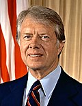
The city remained a small and quiet one until Plains native Jimmy Carter rose to political prominence as Georgia's governor in 1971, before becoming U.S. president from 1977 to 1981. [9] During the 1976 presidential election and for many years afterwards, the city saw a giant influx in tourism off the back of Carter's name, with nearly 10,000 people (around 18 times the population of Plains) pouring into the community daily. [10]
According to the United States Census Bureau, the city has a total area of 0.8 square miles (2.1 km2), all land. The city's boundary is in the shape of a circle. [11] [12] Plains has a center longitude/latitude point which is -83.0813/33.4553. It is located in west-south-western Georgia, 120 miles (190 km) due south of Atlanta.
Many of the town’s attractions are related to the Jimmy Carter National Historical Park. Carter's high school, birthplace, campaign headquarters, former site of family business, and his brother Billy's service station are all within a close vicinity of one another in the center of town. The iconic Smiling Peanut Statue, a gift to Carter from supporters in Evansville, Indiana, lies on the outskirts of town. His boyhood home is in nearby Archery.
Andersonville National Historic Site and the National Prisoner of War Museum are located in the vicinity of Plains. Georgia Southwestern State University is located in the nearby town of Americus. Westville, a re-created town depicting the living history of mid-19th-century Georgia, is located in the nearby town of Lumpkin.
This area climate is characterized by hot, humid summers and generally mild to cool winters. According to the Köppen Climate Classification system, Plains has a humid subtropical climate, abbreviated "Cfa" on climate maps. [13]
Climate data for Plains, Georgia | |||||||||||||
---|---|---|---|---|---|---|---|---|---|---|---|---|---|
Month | Jan | Feb | Mar | Apr | May | Jun | Jul | Aug | Sep | Oct | Nov | Dec | Year |
Mean daily maximum °F (°C) | 57 (14) | 61 (16) | 68 (20) | 77 (25) | 84 (29) | 89 (32) | 91 (33) | 90 (32) | 86 (30) | 78 (26) | 69 (21) | 60 (16) | 76 (24) |
Mean daily minimum °F (°C) | 35 (2) | 37 (3) | 44 (7) | 51 (11) | 60 (16) | 67 (19) | 69 (21) | 69 (21) | 64 (18) | 53 (12) | 44 (7) | 37 (3) | 52 (11) |
Average precipitation inches (mm) | 4.9 (120) | 4.6 (120) | 5.2 (130) | 3.5 (89) | 3.3 (84) | 4.7 (120) | 5.2 (130) | 4.5 (110) | 3.5 (89) | 2.4 (61) | 3.3 (84) | 4.2 (110) | 49.4 (1,250) |
Source: Weatherbase [14] |
Census | Pop. | Note | %± |
---|---|---|---|
1870 | 374 | — | |
1880 | 459 | 22.7% | |
1890 | 510 | 11.1% | |
1900 | 290 | −43.1% | |
1910 | 407 | 40.3% | |
1920 | 479 | 17.7% | |
1930 | 406 | −15.2% | |
1940 | 364 | −10.3% | |
1950 | 359 | −1.4% | |
1960 | 273 | −24.0% | |
1970 | 236 | −13.6% | |
1980 | 231 | −2.1% | |
1990 | 286 | 23.8% | |
2000 | 283 | −1.0% | |
2010 | 776 | 174.2% | |
2020 | 573 | −26.2% | |
U.S. Decennial Census [15] 1850-1870 [16] 1870-1880 [17] 1890-1910 [18] 1920-1930 [19] 1940 [20] 1950 [21] 1960 [22] 1970 [23] 1980 [24] 1990 [25] 2000 [26] 2010 [27] 2020 [28] |
Race / Ethnicity | Pop 2000 [29] | Pop 2010 [27] | Pop 2020 [28] | % 2000 | % 2010 | % 2020 |
---|---|---|---|---|---|---|
White alone (NH) | 238 | 392 | 239 | 37.36% | 50.52% | 41.71% |
Black or African American alone (NH) | 379 | 331 | 307 | 59.50% | 42.65% | 53.58% |
Native American or Alaska Native alone (NH) | 0 | 0 | 1 | 0.00% | 0.00% | 0.17% |
Asian alone (NH) | 0 | 0 | 3 | 0.00% | 0.00% | 0.52% |
Pacific Islander alone (NH) | 0 | 0 | 0 | 0.00% | 0.00% | 0.00% |
Some Other Race alone (NH) | 0 | 0 | 0 | 0.00% | 0.00% | 0.00% |
Mixed Race/Multi-Racial (NH) | 2 | 2 | 5 | 0.31% | 0.26% | 0.87% |
Hispanic or Latino (any race) | 18 | 51 | 18 | 2.83% | 6.57% | 3.14% |
Total | 637 | 776 | 573 | 100.00% | 100.00% | 100.00% |
As of the 2000 census, [3] there were 637 people, 215 households, and 136 families residing in the city. The population density was 780.0 inhabitants per square mile (301.2/km2). There were 244 housing units at an average density of 298.8 per square mile (115.4/km2). The racial makeup of the city was 38.62% White, 59.81% African American, 1.26% from other races, and 0.31% from two or more races. Hispanic or Latino of any race were 2.83% of the population. There were 215 households, out of which 25.6% had children under the age of 18 living with them, 36.7% were married couples living together, 24.2% had a female householder with no husband present, and 36.3% were non-families. 34.9% of all households were made up of individuals, and 19.5% had someone living alone who was 65 years of age or older. The average household size was 2.50 and the average family size was 3.31.
In the city, the population was spread out, with 24.6% under the age of 18, 8.5% from 18 to 24, 16.5% from 25 to 44, 20.3% from 45 to 64, and 30.1% who were 65 years of age or older. The median age was 45 years. For every 100 females, there were 69.0 males. For every 100 females age 18 and over, there were 58.9 males.
The median income for a household in the city was $26,719, and the median income for a family was $29,375. Males had a median income of $24,375 versus $16,406 for females. The per capita income for the city was $11,602. About 22.2% of families and 25.6% of the population were below the poverty line, including 47.2% of those under age 18 and 17.3% of those age 65 or over.
Former President Jimmy Carter was born in Plains at the Wise Sanitarium, now renamed the Lillian G. Carter Nursing Center in honor of his mother. His wife Rosalynn and their daughter Amy were also born in Plains, as were his younger brother Billy, younger sister Gloria, youngest sister Ruth, and cousin Hugh. When he left office in 1981, Carter and his wife returned to live in the home in Plains they have occupied since 1961; Rosalynn died in November 2023.
Andersonville is a city in Sumter County, Georgia, United States. As of the 2020 census, the city had a population of 237. It is located in the southwest part of the state, approximately 60 miles (97 km) southwest of Macon on the Central of Georgia railroad. During the American Civil War, it was the site of a prisoner-of-war camp, which is now Andersonville National Historic Site.
Chambers County is a county located in the east central portion of the U.S. state of Alabama. As of the 2020 census the population was 34,772. Its county seat is LaFayette. Its largest city is Valley. Its name is in honor of Henry H. Chambers, who served as a United States Senator from Alabama.
Sumter County is a county located in the west-central portion of the U.S. state of Georgia. As of the 2020 census, its population was 29,616. The county seat is Americus. The county was created on December 26, 1831.
Wagner is a city in Charles Mix County, South Dakota, United States. The population was 1,490 at the 2020 census. The city is served by Wagner Municipal Airport as well as YST Transit buses.
Loudon is a city in and the county seat of Loudon County, Tennessee, United States. Its population was 6,001 at the 2020 census. It is included in the Knoxville, Tennessee Metropolitan Statistical Area. The city is located in East Tennessee, southwest of Knoxville, on the Tennessee River. Fort Loudoun, the colonial era fort for which the city was named, is located several miles to the south in Monroe County.
Silverton is a city in Briscoe County, Texas, United States. The population was 629 at the 2020 census.
De Leon is a city located in Comanche County in the U.S. state of Texas. Its population was 2,246 in the 2020 census. It is commonly associated with being named after the Spanish explorer Ponce de León, but the town is actually named for its location on the Leon River, which flows directly north and east of the community, and drains into nearby Proctor Lake.
Plainview is a city in and the county seat of Hale County, Texas, United States. As of the 2020 census, its population was 20,187.
Grapeland is a city in Houston County, Texas, United States. Its population was 1,465 as of the 2020 census.
Slaton is a city in Lubbock County, Texas, United States. Founded by German immigrants, Slaton was the westernmost German settlement in Texas. The population was 6,121 at the 2010 census. Slaton is part of the Lubbock Metropolitan Statistical Area.
Bishop is a city in Nueces County, Texas, United States. The population was 3,134 in the 2010 census, down from 3305 at the 2000 census.
Strawn is a city in Palo Pinto County, Texas, United States. The population was 653 at the 2010 census. Strawn, on State Highway 16 and 108, Farm to Market Road 2372, and the Missouri Pacific Railroad in southwestern Palo Pinto County, was one of several towns developed about 1880 when the Texas and Pacific Railway began service. The site, known earlier as North Fork for its location on Palo Pinto Creek, was laid out on the land of two early ranchers, Stephen Bethel Strawn and James N. Stuart. Stuart built the area's first house in 1875. A community to the west, Russell's Pocket, and one to the east, Davidsonville, were merged to form Strawn.
Emory is a city in Rains County, Texas, United States. The population was 1,239 at the 2010 census. It is the county seat of Rains County. Previously known as Springville, the city and county are named after Emory Rains, who was a legislator from the area. Rains was the author of the Homestead Law of Texas, which was later used as a model for the protection of homesteads throughout the United States. Special legislation passed to create Rains County called for the citizens to vote on the location of the county seat and for that selected town to be named Emory.
Tye is a city in Taylor County, Texas, United States. The population was 1,242 at the 2010 census. It is part of the Abilene, Texas Metropolitan Statistical Area.
Woodville is a town in Tyler County, Texas, United States. The town is intersected by three U.S. highways: U.S. Highway 69, U.S. Highway 190, and U.S. Highway 287. The population was 2,403 at the 2020 census. It is the county seat of Tyler County. The town was named after George Tyler Wood, governor of Texas from 1847 to 1849.
Burnsville is a town in Braxton County, West Virginia, United States, at the confluence of the Little Kanawha River and Saltlick Creek. The population was 401 at the 2020 census. Burnsville was incorporated in 1902 by the Circuit Court and named for Captain John Burns who operated the first sawmill in that section of the state and who established the town shortly after the close of the American Civil War. It was named "All West Virginia City" in 1976.
Henderson is an unincorporated community and former town in Mason County, West Virginia, United States, at the confluence of the Ohio and Kanawha Rivers. The population was 231 at the 2020 census. It is part of the Point Pleasant, WV–OH Micropolitan Statistical Area. The town was incorporated in 1893 and named for Samuel Bruce Henderson, who owned the townsite at the time. The town was unincorporated following a public hearing on August 11, 2022.
Ackerly is a city in Dawson and Martin Counties in the U.S. state of Texas. As of the 2020 Census, the population was 264. The Martin county portion of Ackerly is part of the Midland-Odessa metropolitan area.
The Americus micropolitan statistical area, as defined by the United States Census Bureau, is an area consisting of two counties in Georgia, anchored by the city of Americus.
Bibb City was a city in west-central Georgia, United States. It had been the company town of the Bibb Manufacturing Company in Muscogee County, and had a population of 510 in its last official U.S. census (2000). The entire city area, consisting of historic Columbus Mill and the associated mill village owned by the company, is now part of the consolidated city-county of Columbus. It is listed in the National Register of Historic Places as Bibb City Historic District.