List of bridges and viaducts in Lincolnshire

Last updated

This is a list of all the bridges and viaducts in the ceremonial county of Lincolnshire, England.

Contents

Bridges are listed under their current use or traffic. For example, Torksey Viaduct is listed under 'Highway' as it is now used by foot and cycle traffic, and not under 'Railway' as it used to be. However, if the bridge or viaduct has not been re-purposed yet it listed in the section of its original use.

Railway bridges

NameCrossesLocalityLength (m)Longest Span (m)DateType Grade NotesImage
Barkston East Junction Railway Bridge River Witham Barkston Carries Grantham to Sleaford Line (Poacher Line).
Barkston Junction Bridge Grantham to Sleaford Line (Poacher Line). Barkston Steel BeamCarries East Coast Main Line. Bridge No7a Bridge No7a - geograph.org.uk - 423235.jpg
Barkston North Junction Railway Bridge River Witham Marston Carries East Coast Main Line
Brigg Railway Bridge New River Ancholme Brigg Carries Gainsborough to Grimsby railway.
Cadney Road Railway Bridge Old River Ancholme, Cadney Road Brigg Iron Box GirderCarries Gainsborough to Grimsby railway. Railway bridge - geograph.org.uk - 861611.jpg
Claypole Railway Bridge River Witham Claypole Carries the East Coast Main Line.
Coningsby Railway Bridge 1Hunter's Lane (Unclassified road) Coningsby 1913Carried the Kirkstead and Little Steeping Railway. Now partially dismantled.
Coningsby Railway Bridge 2 River Bain Coningsby 1913Brick ArchCarried the Kirkstead and Little Steeping Railway. Railway Bridge at Coningsby - geograph.org.uk - 102197.jpg
Coningsby Railway Bridge 3 A153 Tumby Road Coningsby 1913Carried the Kirkstead and Little Steeping Railway. Now dismantled.
Cow Bridge Drain Railway BridgeCow Bridge DrainCowbridge, Boston Carries the Poacher Line (Nottingham to Skegness)
East Holmes Bridge River Witham Lincoln Brick ArchCarries the Newark to Lincoln Line. East Holmes - geograph.org.uk - 999046.jpg
Grand Sluice Railway Bridge River Witham Boston 1885Iron Truss BridgeIIDesigned by Richard Johnson. Originally double track but now single. Carries the Poacher Line. Grand Sluice - geograph.org.uk - 967039.jpg
Keadby Bridge River Trent Althorpe 167461916Rolling liftIIAlso known as the King George V Bridge. Combined road and rail bridge. Keadby Bridge - geograph.org.uk - 3126.jpg
Maud Foster Railway BridgeMaud Foster Drain Boston 30301922Iron Box GirderCarries the Poacher Line (Nottingham to Skegness) Maud Foster Bridge - geograph.org.uk - 718556.jpg
Saxilby Rail Bridge Foss Dyke Saxilby Iron BeamCarries Lincoln to Gainsborough Line Foss Dyke Bridge - Saxilby (geograph 4495575).jpg
Spalding East Railway Bridge Coronation Channel (River Welland) Spalding Iron BeamDisused. The Coronation Channel, Spalding - geograph.org.uk - 841265.jpg
Spittlegate Railway Bridge River Witham Spittlegate Carries the East Coast Main Line.
Stamp End Bridge River Witham Lincoln 201848/1903Iron Box GirderIIOldest Iron Box Girder Bridge in Britain and possibly the World. Partially reconstructed in 1903. Railway Bridge over River Witham (geograph 2435952).jpg
Swing Bridge (Boston Docks) River Witham Boston 1884Iron Swing BridgeIICarries a branch into Boston Docks. Docks swing bridge - geograph.org.uk - 968982.jpg
Trent Junction Railway Bridge River Trent Gainsborough 138Carries the Sheffield to Lincoln Line. Gainsborough Trent Junction Railway Bridge - geograph.org.uk - 253500.jpg
Vazon Sliding Railway Bridge Stainforth and Keadby Canal Keadby Sliding Bridge Vazon Sliding Bridge.jpg
Worlaby Railway Bridge River Ancholme Worlaby Iron Box GirderCarries the Scunthorpe to Grimsby Line. Rail Bridge over the New River Ancholme - geograph.org.uk - 336584.jpg

Highway bridges

A

NameCrossesLocalityLength (m)Longest Span (m)DateType Grade NotesImage
Agnes Street Footbridge River Witham Grantham Public footpath.
Aswardby Bridge River Lymn Aswardby
Aubourne Bridge 1 River Witham Aubourn Steel trussPublic bridleway. Deemed unsafe by Lincolnshire County Council with users advised to use the next bridge upstream. Unsafe Bridge Over Witham - geograph.org.uk - 155505.jpg
Aubourne Bridge 2 River Witham Aubourn Concrete beamPublic footpath The safe bridge - geograph.org.uk - 1263164.jpg
Aubourne Fen Bridge River Brant Aubourn Carries farm track. No public access.
Aubourne Weir Footbridge River Brant Aubourn Concrete beamPublic footpath. Part of the weir infrastructure. Also known as Mill Weir and Haddington Weir. Haddington Weir - geograph.org.uk - 142916.jpg

B

NameCrossesLocalityLength (m)Longest Span (m)DateType Grade NotesImage
Bardney Bridge River Witham Bardney 30301894Iron TrussBuilt by Sherwin Reynolds & Son of Boston. Carries B1190. Single track. Bardney Bridge and Sloop House - geograph.org.uk - 517511.jpg
Bardney Lock Bridge River Witham Bardney and Branston Island78Iron Box GirderCarries the Water Rail Way, part of the National Cycle Network (Route 1) managed by Sustrans. It used to carry the Lincolnshire Loop Line (Boston to Lincoln). Bardney Lock Bridge - geograph.org.uk - 95322.jpg
Bargate Sluice Footbridge 1 River Witham Boultham, Lincoln Concrete BeamPublic Footpath.
Bargate Sluice Footbridge 2Sincil Dike Boultham, Lincoln Steel ArchPublic Footpath.
Bargate Sluice Footbridge 3Sincil Dike Boultham, Lincoln Steel ArchPublic Footpath. Also known as Webb Street Footbridge.
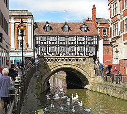
Barkston Bridge River Witham Barkston Brick ArchCarries Station Road (minor road) between Barkston and Marston. Bridge over the River Witham - geograph.org.uk - 1068319.jpg
Barkston Pipe Bridge River Witham Barkston Pipe Bridge
Barnby Bridge 1 River Witham Barnby in the Willows Carries farm track. Public footpath.
Barnby Bridge 2 River Witham Barnby in the Willows Carries farm track. Public footpath.
Footbridge River Witham Barnby in the Willows Public footpath
Bassingham Fen Bridge River Brant Bassingham Carries farm track. No public access.
Beckingham Bridge 1 River Witham Beckingham Carries farm track. No public access.
Beckingham Bridge 2 River Witham Beckingham Carries farm track. No public access.
Belton Bridge 1 River Witham Belton Carries Belton Bypass A607.
Belton Bridge 2 River Witham Belton 1903Stone ArchIICarries Main Road (minor road) through Belton.
Belton Footbridge 1 River Witham Belton Part of the Belton House Estate.
Belton Footbridge 2 River Witham (former course) Belton Part of the Belton House Estate.
Belton Footbridge 3 River Witham Belton Timber Beam Part of the Belton House Estate.
Belton Footbridge 4 River Witham (former course) Belton Timber Beam Part of the Belton House Estate.
Birdhouse Clough Pipe Bridge River Ancholme Worlaby Steel TrussCarries pipelines. Birdhouse Clough Pipe Bridge - geograph.org.uk - 338247.jpg
Bishop Bridge River Ancholme Bishopbridge Carries A631. Confluence of the Rivers Ancholme and Rase, and the beginning of the New River Ancholme drainage channel. Bishopbridge 48 Hour Visitor Moorings and Porting Point - geograph.org.uk - 1104687.jpg
Bishopbridge Weir Footbridge River Ancholme Bishopbridge Iron TrussNo public Access. Part of the weir infrastructure. Point at which the Ancholme ceases to be navigable. Bishop Bridge Weir - geograph.org.uk - 783642.jpg
Black Dike BridgeBlack Dike Waddingham Brick ArchCarries B1205. Black Dike Bridge - geograph.org.uk - 124310.jpg
Black Dike FootbridgeBlack Dike Waddingham Steel ArchPublic Footpath. Black Dyke footbridge - geograph.org.uk - 1590604.jpg
Black Sluice Pumping Station South Forty Foot Drain Boston 1946The road bridge is part of the sluice infrastructure. Black Sluice Pumping Station - geograph.org.uk - 694452.jpg
Blackmoor Bridge River Brant Aubourn Carries Blackmoor Road (minor road) between Harmston and Aubourn.
Blackmoor Farm Bridge River Witham Aubourn Carries farm track. No public access.
Boultham Avenue Bridge River Witham Lincoln Concrete BeamCarries Boultham Avenue (minor road). Eastern Terrace - geograph.org.uk - 304091.jpg
Brace Bridge River Witham Bracebridge, Lincoln 1927Stone ArchCarries A1434. Site of ancient crossing of the Roman Fosse Way of the River Witham. Brace Bridge - geograph.org.uk - 681006.jpg
Brandon Bridge 1 River Brant Brandon Carries farm track. Public footpath.
Brandon Bridge 2 River Brant Brandon Carries farm track
Brandon Bridge 3 River Brant Brandon Carries Hough Road (minor road) between Brandon and Hough on the Hill.
Brandon Bridge 4 River Brant Brandon Carries Grange Road (minor road) between Brandon and Hough on the Hill.
Brandy Wharf Bridge New River Ancholme Waddingham Iron ArchCarries B1205. The Bridge at Brandy Wharf - geograph.org.uk - 315106.jpg
Brant Broughton Bridge River Brant Brant Broughton Concrete beamCarries minor rod between Brant Broughton and Welbourn.
Brayford Flyover Fossdyke Navigation Lincoln 1521996Steel BeamCarries B1273.
Brayford Wharf East Footbridge 1 River Witham Lincoln Steel ArchDisused
Brayford Wharf East Footbridge 2 River Witham Lincoln Concrete BeamProvides access to the University of Lincoln.
Bridge End Road Bridge River Witham Grantham Carries Bridge End Road (A52).
Bridgewater House Footbridge 1 River Witham Belton No public access.
Bridgewater House Footbridge 2 River Witham Belton No public access.
Brigg Pipe Bridge River Ancholme Brigg Carries pipeline.
Broughton Bridge River Ancholme Broughton 19th centuryIron Inverted SuspensionIICarries farm track. Public Footpath. Broughton Bridge - geograph.org.uk - 339442.jpg
Brown's Bridge River Ancholme Snitterby 19th centuryIron ArchCarries farm track. No public access. Brown's Bridge - geograph.org.uk - 782614.jpg
Bycroft's Bridge River Lymn Wainfleet Bank Carries Brewster Lane (minor road) between Wainfleet Bank and Wainfleet All Saints.

C

NameCrossesLocalityLength (m)Longest Span (m)DateType Grade NotesImage
Cadney Bridge River Ancholme Cadney 1882Iron ArchIICarries farm track. Public Footpath. Designed by Alfred Atkinson. Cadney Bridge - geograph.org.uk - 310290.jpg
Caistor Canal Lock 1 Bridge Caistor Canal South Kelsey 1795Steel ArchIIPublic Footpath. Listing due to abutments not the span itself. Footbridge Over Disused Caistor Canal - geograph.org.uk - 1106862.jpg
Carlton Lowfield Footbridge River Brant Carlton-le-Moorland Steel BeamPublic footpath Footbridge over River Brant - geograph.org.uk - 514809.jpg
Castlethorpe Bridge River Ancholme Castlethorpe Iron TrussCarries farm track. Public Footpath. Castlethorpe Bridge - geograph.org.uk - 178006.jpg
Castlethorpe Pipe Bridge River Ancholme Castlethorpe Steel TrussCarries pipeline. Castlethorpe Pipebridge - geograph.org.uk - 178018.jpg
Caythorpe Low Fields Bridge 1 River Brant Caythorpe Carries farm track. No public access.
Caythorpe Low Fields Bridge 2 River Brant Caythorpe Carries Gorse Hill Lane (minor road) between Brandon and Caythorpe. Weak bridge over the River Brant - geograph.org.uk - 256845.jpg
Caythorpe Low Fields Bridge 2 River Brant Brandon Carries farm track. No public access.
Chain Bridge (new) River Lymn Wainfleet All Saints Concrete BeamCarries A52.
Chain Bridge (old) River Lymn Wainfleet All Saints Iron BeamNo public access. Carries farm track; it was a minor road before the New Chain Bridge (A52 Wainfleet Bypass) was built. Dovecote Lane, near Wainfleet All Saints (geograph 2289788).jpg
Childers North Drove Coronation Channel (River Welland) Spalding Concrete BeamCarries farm track. Public bridleway. Going fishing - geograph.org.uk - 841258.jpg
Childers South Drove Coronation Channel (River Welland) Spalding Carries farm track. Public bridleway.
Church Bridge River Witham Bassingham Concrete BeamPublic footpath Church Bridge - geograph.org.uk - 1753609.jpg
City Square Bridge River Witham Lincoln Steel ArchFootbridge connecting City Square and the Waterside Shopping Centre. The River Witham, Lincoln - geograph.org.uk - 690371.jpg
Claypole Bridge River Witham Claypole Brick ArchCarries Shire Lane (minor road) between Balderton and Claypole. Claypole Road Bridge - geograph.org.uk - 560905.jpg
Claypole Footbridge River Witham Claypole Steel BeamPublic footpath Footbridge over the Witham (geograph 4066920).jpg
Clough Bridge River Lymn Firsby Carries minor road between Thorpe Fendykes and Firsby.
Clough Bridge River Lymn Wainfleet Clough No public access. Carries farm track.
College Street Footbridge River Witham Grantham Public footpath.
Corporation Bridge Alexandra Dock Grimsby 1501925BasculeDesigned by Charles Sacre. Replaced an earlier bridge from 1872. Corporation Bridge.jpg
County Bridge Old River Ancholme Brigg 1828Stone ArchIIAlso known as Old Town Bridge. Brigg - The Old Town Bridge - geograph.org.uk - 178020.jpg
Cow BridgeMaud Foster DrainCowbridge, Boston 1811Iron ArchIIPublic Footpath. Cast at the Butterley Works in Derbyshire. Cowbridge footbridge - geograph.org.uk - 674590.jpg
Cowbit Road Bridge Coronation Channel (River Welland) Spalding Concrete BeamCarries Cowbit Road (B1172) between Spalding and Spalding Bypass. Coronation Channel - geograph.org.uk - 986879.jpg
Cowbridge Lock FootbridgeWest Fen DrainCowbridge, Boston Concrete BeamPublic Footpath. Part of sluice/lock infrastructure. Cowbridge Lock - geograph.org.uk - 674598.jpg
Crosskeys Bridge River Nene Sutton Bridge 1897SwingII*Formerly carried a railway. Cross Keys Bridge - geograph.org.uk - 1528302.jpg
Crowle Bridge (New) Stainforth and Keadby Canal and South Humberside Main Line Crowle Concrete BeamCarries A161. Replaced a swing bridge. Beside the canal - geograph.org.uk - 375750.jpg
Crow's Bridge River Lymn Wainfleet Bank 1812Brick ArchIICarries minor road between Wainfleet Bank and Wainfleet All Saints. Designed by John Rennie. Crow's Bridge - geograph.org.uk - 266960.jpg

D

NameCrossesLocalityLength (m)Longest Span (m)DateType Grade NotesImage
Dale BridgeThe Dale West Rasen Concrete BeamCarries A631.
Dixon Street Bridge River Witham Lincoln Concrete ArchCarries Dixon Street (B1360). Dixon Street Bridge (geograph 4709803).jpg
Doddington Bridge River Witham Dry Doddington Concrete BeamCarries Doddington Lane (minor road) between Dry Doddington and the A1. Doddington Bridge - geograph.org.uk - 77736.jpg
Duckpool BridgeCatchwater Drain Stixwould Concrete ArchCarries minor road (C603) between Stixwould and Bucknall/Horsington. Duckpool Bridge crossing Catchwater Drain (geograph 2664793).jpg
Dudley Road Footbridge River Witham Grantham Steel ArchPublic footpath. Footbridge, River Witham (geograph 3654140).jpg
Dunham Bridge River Trent Dunham-on-Trent 1832/1979Steel BeamCurrent bridge rebuilt on original piers. Geograph 312987 Dunham Bridge.jpg

E

NameCrossesLocalityLength (m)Longest Span (m)DateType Grade NotesImage
East Drain BridgeEast Drain Owersby Brick ArchPublic Footpath. Bridge Over East Drain Near New River Ancholme - geograph.org.uk - 789149.jpg

F

NameCrossesLocalityLength (m)Longest Span (m)DateType Grade NotesImage
Ferriby Sluice Bridge 1 New River Ancholme Ferriby Sluice Lift BridgeScheduled Ancient MonumentCarries A1077. Part of the sluice infrastructure. Ferriby Sluice is a Scheduled Ancient Monument. Lifting Bridge at Ferriby Sluice - geograph.org.uk - 718143.jpg
Ferriby Sluice Bridge 2 New River Ancholme Ferriby Sluice Concrete BeamScheduled Ancient MonumentCarries A1077. Part of the sluice infrastructure. Ferriby Sluice is a Scheduled Ancient Monument. South Ferriby Sluice and Lock - geograph.org.uk - 321629.jpg
Ferriby Sluice Bridge 3 Old River Ancholme Ferriby Sluice Stone ArchScheduled Ancient MonumentCarries Public Footpath. Ferriby Sluice is a Scheduled Ancient Monument. Old River Ancholme Sluice - geograph.org.uk - 224788.jpg
Ferriby Sluice Conveyor Bridge 1 B1204 Road Ferriby Sluice Steel TrussCarries clay and cement and clay between the quarry and cement works.
Ferriby Sluice Conveyor Bridge 2 River Ancholme Ferriby Sluice Steel TrussCarries clay and cement and clay between the quarry and cement works. Conveyor Bridge at South Ferriby - geograph.org.uk - 311479.jpg
Ferriby Sluice Footbridge Old River Ancholme Ferriby Sluice Steel Truss Footbridge at Ferriby Sluice - geograph.org.uk - 1221315.jpg
Ferry Farm Pipe Bridge Foss Dyke, Lincoln to Gainsborough Line (rail) Skellingthorpe Steel Truss The Fossdyke - geograph.org.uk - 1251887.jpg
Firth Road Footbridge River Witham Lincoln Concrete ArchPublic Footpath. Immediately parallel to Firth Road Bridge. View from Station Street Bridge - geograph.org.uk - 1483880.jpg
Firth Road Bridge River Witham Lincoln Iron Box GirderCarries Firth Road (minor road). Firth Road bridge in New Boultham, Lincoln (geograph 4709915).jpg
Five Mile Bridge River Witham Fiskerton Steel TrussFootbridge connecting the Water Rail Way (south bank) to the north bank and Fiskerton. So named since it is five miles east of Lincoln. Five Mile Bridge - geograph.org.uk - 1718808.jpg
Fosdyke Bridge River Welland Fosdyke Steel BeamCarries A17. Lowest crossing of the River Welland. Location has been an important river crossing for centuries and reputedly the location where King John lost his treasure. Fosdyke Bridge - geograph.org.uk - 1436003.jpg
Fulbeck Low Fields Bridge River Brant Stragglethorpe Carries Brant Road (minor road) between Fulbeck and Stragglethorpe.
Fulbeck Low Fields footbridge River Brant Stragglethorpe No public access.

G

NameCrossesLocalityLength (m)Longest Span (m)DateType Grade NotesImage
Gaunt Street Footbridge River Witham Lincoln Iron TrussDisused?
Gipsey BridgeCastle Dyke Gipsey Bridge Brick ArchCarries B1184 Gipsey Bridge - geograph.org.uk - 711560.jpg
Glanford Bridge Old River Ancholme Brigg Steel BeamCarries A18. A18 Bridge over New River Ancholme - geograph.org.uk - 178085.jpg
Godnow Bride Stainforth and Keadby Canal Crowle Swing Bridge Godnow Bridge - geograph.org.uk - 140519.jpg
Grand Sluice River Witham Boston 1766/1883IISluice designed by John Grundy and Langley Edwards. The road bridge is part of the sluice infrastructure and was added in the early 20th century. View from St Botolphs - upstream on the Witham (geograph 2674701).jpg
Grantham Bridge 1 River Witham Grantham Carries Belton Lane (minor road) through Grantham.
Grantham Footbridge 1 River Witham Grantham Steel ArchPublic footpath.
Great Ponton Bridge River Witham Great Ponton Carries Dallygate Lane (minor road) between Great Ponton and Ermine Street (B6403).
Great Ponton Mill Footbridge River Witham Great Ponton Part of watermill infrastructure. No public access.

H

NameCrossesLocalityLength (m)Longest Span (m)DateType Grade NotesImage
Haddington Bridge River Witham Haddington Concrete beamCarries Bridge Road (minor road) between Haddington and Aubourn.
Haltham Lock Footbridge River Bain Haltham Concrete BeamPublic Footpath. Part of the weir (formally lock) infrastructure. Haltham Lock - geograph.org.uk - 1422563.jpg
Haltoft End BridgeHobhole Drain Haltoft End Carries A52.
Halton Bridge River Lymn Halton Holegate Carries B1195. Halton Bridge - geograph.org.uk - 235063.jpg
Hambleton Bridge River Witham Syston Concrete BeamCarries farm track. Public footpath.
Harlem Hill Lock Footbridge 1 River Ancholme Bishop Norton Steel ArchBridge also part of the lock infrastructure. Harlam Hill Lock - geograph.org.uk - 782634.jpg
Harlem Hill Lock Footbridge 2 River Ancholme Bishop Norton Steel BeamPart of weir (former lock) infrastructure. New River Ancholme - geograph.org.uk - 783678.jpg
Harrowby Mill Bridge River Witham Manthorpe Concrete BeamPart of weir (former mill) infrastructure.
Haven Bridge River Witham Boston 1966Concrete ArchCarries the A16 John Adams Way The Haven - geograph.org.uk - 990480.jpg
Hibaldstow Bridge River Ancholme near Hibaldstow 1889Iron ArchII Hibaldstow Bridge - geograph.org.uk - 1596654.jpg
High Bridge River Witham Lincoln 1160Stone ArchIOldest bridge in Britain with buildings on it. High Bridge, High Street, Lincoln.jpg
Holbeach Road Bridge Coronation Channel (River Welland) Spalding Concrete BeamCarries Holbeach Road (A151) through Spalding. Bridge From Weston. - geograph.org.uk - 1163876.jpg
Holme Barn Farm Bridge River Witham Claypole Carries farm track. No public access.
Horkstow Bridge New River Ancholme Horkstow 42.61836SuspensionII*Designed by Sir John Rennie. Horkstow suspension bridge.jpg
Hospital BridgeMaud Foster Drain Boston 1811Iron ArchIIPublic Footpath. Cast at the Butterley Works in Derbyshire. Hospital Bridge - geograph.org.uk - 679856.jpg
Hougham Footbridge 1 River Witham Hougham No public access
Hougham Footbridge 2 River Witham (former course) Hougham Public footpath
Hougham Weir Footbridge River Witham Hougham Public footpath. Part of the weir infrastructure. Witham weir (geograph 3981482).jpg
Hubbert's Bridge South Forty Foot Drain Hubberts Bridge 17171888Brick ArchCarries B1192. Designed by John Kingston, the County Surveyor for the Parts of Holland. Bridge over the South Forty Foot Drain, Hubbert's Bridge, Lincs - geograph.org.uk - 172776.jpg
Humber Bridge The Humber Barton-upon-Humber 2,2201,4101981SuspensionLongest single-span in the UK and formerly the World Humber Bridge.jpg
Hykeham Bridge River Witham North Hykeham Concrete BeamCarries Meadow Lane (minor road) between North Hykeham and Waddington. Hykeham Bridge - geograph.org.uk - 502331.jpg
Hykeham Footbridge River Witham North Hykeham Concrete BeamPublic Footpath. Footbridge over the Witham - geograph.org.uk - 171311.jpg

I

NameCrossesLocalityLength (m)Longest Span (m)DateType Grade NotesImage
Ings BridgeHobhole DrainBoston Long HedgesBrick arch Ings Bridge - geograph.org.uk - 235099.jpg

K

NameCrossesLocalityLength (m)Longest Span (m)DateType Grade NotesImage
Keadby Bridge River Trent Althorpe 167461916Rolling liftIIAlso known as the King George V Bridge. Combined road and rail bridge. Keadby Bridge - geograph.org.uk - 3126.jpg
Kelsey BridgeCow Bridge Drain Boston, north of.Carries A16.
Kirkby on Bain Footbridge River Bain Kirkby on Bain Concrete BeamPublic Footpath Footbridge over disused Horncastle canal - geograph.org.uk - 820675.jpg
Kirkstead Bridge River Witham Woodhall Spa 293351968Concrete ArchCarries B1191 Kirkstead Bridge Visitor Moorings - geograph.org.uk - 771650.jpg

L

NameCrossesLocalityLength (m)Longest Span (m)DateType Grade NotesImage
Langrick Bridge River Witham Langrick 1909Steel TrussCarries B1192 Langrick Bridge, Langrick - geograph.org.uk - 814952.jpg
Leadenham Mill Bridge River Brant Brant Broughton Carries A17
Lincoln University Footbridge 1 River Witham Lincoln Concrete Arch The Engine Shed - Brayford Wharf East - geograph.org.uk - 1484517.jpg
Lincoln University Footbridge 2 River Witham Lincoln Steel Truss ArchDisused Rusty Bridge - Brayford Wharf East - geograph.org.uk - 1482990.jpg
Little Ponton Bridge River Witham Little Ponton 1922Concrete BeamCarries Whalebone Lane (minor road) between Little Ponton and Woodnock. River Witham, near Park Farm - geograph.org.uk - 700775.jpg
Long Bennington Bridge 1 River Witham Long Bennington Carries Westborough Lane (minor road) between Long Bennington and Westborough.
Long Bennington Bridge 2 River Witham Long Bennington Concrete BeamCarries farm track. Public footpath. Carries Viking Way.
Long Bennington Footbridge River Witham Long Bennington Carries unofficial public footpath.
Low Road Bridge Coronation Channel (River Welland) Spalding Carries Low Road (minor road) between Spalding and Spalding Bypass.
Lush's BridgeMill Drain Frithville Concrete BeamCarries B1183.

M

NameCrossesLocalityLength (m)Longest Span (m)DateType Grade NotesImage
M180 Brigg Bridge River Ancholme Brigg Concrete BeamCarries M180 M180 Bridge over New River Ancholme - geograph.org.uk - 178093.jpg
M180 Trent Viaduct River Trent West Butterwick 2711979Concrete ArchCarries M180
Magpie Bridge River Witham Lincoln Stone ArchCarrie Melville Street (A15). Also known as Thorne Bridge. Riverside railings, Lincoln - geograph.org.uk - 703414.jpg
Malcolm Arms BridgeNewham Drain Anton's Gowt Brick ArchCarries minor road. Anton's Gowt bridge - geograph.org.uk - 674522.jpg
Manthorpe Bridge River Witham Manthorpe No public access.
Manthorpe Footbridge 1 River Witham (former course) Manthorpe No public access.
Manthorpe Footbridge 2 River Witham (former course) Manthorpe No public access.
Manthorpe Mill Bridge 1 River Witham Manthorpe No public access.
Manthorpe Mill Bridge 2 River Witham (mill stream course) Manthorpe No public access.
Manthorpe Mill Bridge 3 River Witham Manthorpe No public access.
Market Bridge River Bain Great Sturton Concrete BeamOn the site of the crossing of the Roman Lincoln to Skegness Road of the River Bain. Market Bridge on the River Bain - geograph.org.uk - 44374.jpg
Marlborough Bridge River Brant Marlborough Carries farm track. No public access.
Marsh Road Sluice Bridge Coronation Channel (River Welland) Spalding Carries March Road (minor road) between Spalding and Spalding Marsh. Marsh Road Sluice, Spalding - geograph.org.uk - 188936.jpg
Marston Mill Bridge River Witham Marston Carries farm track. No public access.
Mason's Bridge River Bain Coningsby Steel BeamPublic Footpath
Maud Foster FootbridgeMaud Foster Drain Boston Concrete BeamPublic Footpath Maud Foster Footbridge - geograph.org.uk - 718620.jpg
Melville Street FootbridgeMelville Street (A15) Lincoln Concrete ArchPublic Footpath Ramped footbridge on Melville Street - geograph.org.uk - 1235375.jpg
Mickling Plantation Bridge River Witham Barkston Steel TrussCarries farm track. Public footpath. Carries Viking Way. The Viking Way - geograph.org.uk - 255277.jpg
Mill Bridge River Lymn Great Steeping Carries minor road between Halton Fenside and Great Steeping.
Mill Farm Bridge River Witham Claypole Brick ArchCarries farm track. Public footpath. Mill Farm Bridge and Millpond, Claypole. - geograph.org.uk - 95862.jpg
Mill Farm Bridge River Witham Marston Carries farm track. No public access.

N

NameCrossesLocalityLength (m)Longest Span (m)DateType Grade NotesImage
New Bridge River Rase West Rasen Concrete BeamCarries A631.
New Sleaford Road Bridge River Witham Beckingham Concrete Beam Carries A17 Beckingham Bypass
Newsham Bridge Newsham Lake Brocklesby Estate 1772Stone ArchIProbably designed by Capability Brown Newsham Bridge, Brocklesby Estate (geograph 2082866).jpg
Northorpe Bridge River Lymn Northorpe Carries minor road between Spilsby and Ashby by Partney.
North Bridge River Witham Marston Carries minor road between Marston and Hougham.
North Soak Drain BridgeNorth Soak Drain Crowle Brick Arch North Soak Drain bridge - geograph.org.uk - 1800285.jpg

O

NameCrossesLocalityLength (m)Longest Span (m)DateType Grade NotesImage
Odder Pipe Bridge Foss Dyke, Lincoln to Gainsborough Line (rail) Odder Steel Truss
Old Beckingham Bridge River Witham Beckingham Concrete BeamPublic footpath
Old North Bridge River Witham Marston Brick ArchNo longer used. Replaced by North Bridge.
Old Tollgate Bridge Old River Ancholme South Kelsey 18th centuryBrick ArchII

P

NameCrossesLocalityLength (m)Longest Span (m)DateType Grade NotesImage
Packhorse Bridge River Rase West Rasen 1310Stone ArchII* and Scheduled Ancient MonumentHas 15th-century alterations. Built by Bishop of Lincoln John Dalderby. Also known as Bishop's Bridge, but not to be confused with Bishop's Bridge two miles downstream. Packhorse Bridge - geograph.org.uk - 153075.jpg
Packhorse BridgeUnnamed Stream Utterby 14th centuryStone ArchII* and Scheduled Ancient Monument Packhorse Bridge - geograph.org.uk - 179627.jpg
Paper Mill Farm Bridge River Witham Spittlegate Carries farm track. No public access.
Paper Mill Farm Footbridge River Witham Spittlegate Part of weir infrastructure. No public access.
Partney Bridge River Lymn Partney Carries A16.
Paul's BridgeFrith Bank DrainCowbridge, Boston Concrete BeamCarries B1183.
Pelham Bridge Peterborough to Lincoln Line (rail) and local roads Lincoln 3001958Concrete ArchCarries A15 Dual-Carriageway Lincoln Cathedral, Lincoln - geograph.org.uk - 1519070.jpg
Pilford Bridge River Ancholme Toft next Newton Concrete BeamCarries Highgate Lane (minor road) between Toft next Newton and Normanby-by-Spital. Pilford Bridge - geograph.org.uk - 70164.jpg
Poucher's Bridge Catchwater Drain Bucknall Concrete BeamNo public access. Carries farm track.
Pyewipe Inn Bridge Foss Dyke, Lincoln to Gainsborough Line (rail). Lincoln Concrete BeamCarries Lincoln Bypass (A46) and Sustrans route 64. One at a time if you please - geograph.org.uk - 1174582.jpg

R

NameCrossesLocalityLength (m)Longest Span (m)DateType Grade NotesImage
Raithby BridgeUnknown Stream Raithby Carries minor road between Hagworthingham and Raithby. Raithby Bridge - geograph.org.uk - 483235.jpg
Rawson's BridgeMaud Foster Drain Boston 1805Brick ArchIIPossibly designed by John Rennie Rawson's Bridge - geograph.org.uk - 718582.jpg
Redcross Street Footbridge River Witham Grantham Public footpath.
Red Mill Bridge River Bain Kirkby on Bain Brick ArchCarries Rime's Lane.
Richardson's BridgeWest Fen DrainCowbridge, Boston Brick ArchCarries B1183. Formerly known as Kitchen's Bridge. Richardson's Bridge - geograph.org.uk - 712845.jpg
Riverside Drive Apartments Footbridge River Witham Lincoln Concrete BeamPublic Footpath. Riverside apartments - geograph.org.uk - 495016.jpg
Ropewalk Bridge River Witham Lincoln Brick Arch
Ropewalk Bridge 1 River Witham Lincoln Concrete BeamPublic Footpath. Immediately north of Ropewalk Bridge.
Ropewalk Bridge 2 River Witham Lincoln Steel TrussPublic Footpath. Immediately south of Ropewalk Bridge. River Witham and The Junxion - geograph.org.uk - 1000930.jpg
Russell Street Bridge River Witham Bracebridge, Lincoln 1924Iron BeamPublic footpath. Originally located elsewhere, but moved into current location in 1924.

S

NameCrossesLocalityLength (m)Longest Span (m)DateType Grade NotesImage
Saltersford Bridge River Witham Saltersford No public access.
Saltersford Footbridge 1 River Witham Saltersford No public access.
Saltersford Footbridge 2 River Witham Saltersford No public access.
Saltersford Footbridge 3 River Witham Saltersford No public access.
Sausthorpe Bridge River Lymn Sausthorpe Carries minor road between Raithby and Sausthorpe.
Saxby Bridge River Ancholme Saxby All Saints 19th centuryIron ArchII Saxby All Saints Bridge - geograph.org.uk - 269100.jpg
Saxilby A57 rail bridgeLincoln to Gainsborough Line (rail) Saxilby Concrete BeamCarries A57.
Saxilby Bridge Foss Dyke Saxilby Steel BeamCarries A57.
Saxilby Footbridge 1 Foss Dyke Saxilby Iron TrussPublic footpath. At Saxilby Wharf. On site of previous swing bridge.
Saxilby Footbridge 2 Foss Dyke Saxilby Steel TrussPublic footpath. Parallel to rail bridge. Fosdyke footbridge - geograph.org.uk - 1330576.jpg
Saxilby Pipe Bridge 1 Foss Dyke Saxilby Steel TrussPipe bridge
Saxilby Pipe Bridge 2 Foss Dyke Saxilby Tubular Steel PipePipe bridge
Scawby Bridge New River Ancholme Brigg 1827Stone ArchIICarries A18. Designed by Sir John Rennie. Scawby Bridge - geograph.org.uk - 1133011.jpg
Scotwater Bridge River Witham Norton Disney 1850Brick Arch Scotwater Bridge - geograph.org.uk - 57296.jpg
Sherman's Wath Bridge River Bain West Ashby Carries Sherman's Wath (road)
Short Ferry Bridge Barlings Eau Short Ferry Steel Arch Road bridge, Short Ferry - geograph.org.uk - 487253.jpg
Skerth BridgeSkerth Drain Swineshead Carries A1121.
Skinnand Bridge River Brant Skinnand Carries minor road between Bassingham and Navenby.
Slate Mill Bridge River Witham Grantham Concrete BeamPublic footpath. Slate Mill Bridge - geograph.org.uk - 1209911.jpg
Spalding Bridge 1 River Welland Spalding Concrete BeamCarries A151 through Spalding. Part of roundabout twin bridge. The River Welland - geograph.org.uk - 28250.jpg
Spalding Bridge 2 River Welland Spalding Concrete BeamCarries A151 through Spalding. Part of roundabout twin bridge.
Spalding Bypass Bridge 1 River Welland Spalding Steel ArchCarries Spalding Bypass (A16).
Spalding Bypass Bridge 2 River Welland Spalding Steel ArchCarries Spalding Bypass (A1175). A16 Welland Bridge - geograph.org.uk - 364374.jpg
Spalding Drove Bridge Coronation Channel (River Welland) Spalding Carries Spalding Drover (minor road) between Spalding and Spalding Bypass.
Spalding Road Bridge South Forty Foot Drain Boston Steel BeamCarries A16. Replaced a railway bridge in the same location.
St. Botolph's Footbridge River Witham Boston 2014Steel ArchReplaced a previous footbridge. St Botolph's Footbridge, Boston.jpg
St. Catherine's Road Bridge River Witham Grantham Carries St Catherine's Road (minor road) through Grantham.
Stapleford Church Bridge River Witham Stapleford Concrete Beam Church bridge - geograph.org.uk - 1390258.jpg
Stapleford Bridge River Witham Stapleford Carries Clay Lane (minor road) between Stapleford and Brant Broughton.
Station Street Bridge River Witham Lincoln Carries Station Street (minor road). River Witham - geograph.org.uk - 495001.jpg
Stockwith Mill Bridge River Lymn Harrington Brick ArchCarries Harrington Road (minor road) between Hagworthingham and Harrington The river Lynn, Stockbridge Mill - geograph.org.uk - 1328380.jpg
Stone BridgeStone Bride Drain Frithville Concrete Beam
Stonebridge Road Bridge River Witham Grantham Concrete BeamCarries minor road (Stonebridge Road) through Grantham.
Stragglethorpe Bridge 1River Brant Stragglethorpe Public footpath
Stragglethorpe Bridge 2Sand Beck Stragglethorpe Public footpath
Stragglethorpe Bridge 2Sand Beck Stragglethorpe Carries farm track. No public access.
Swineshead Bridge South Forty Foot Drain Swineshead Bridge Concrete BeamCarries A17. Swineshead Bridge over the South Forty Foot Drain (geograph 4253853).jpg

T

NameCrossesLocalityLength (m)Longest Span (m)DateType Grade NotesImage
Tattershall Bridge (New) River Witham Tattershall 68Carries A153 Tattershall Bridge - geograph.org.uk - 109597.jpg
Tattershall Bridge (Old) River Witham Tattershall Brick ArchFormer highway crossing, now only for pedestrian traffic. Old Tattershall Bridge - geograph.org.uk - 709511.jpg
Tattershall Sluice Footbridge River Bain Tattershall Steel Truss Tattershall Sluice - geograph.org.uk - 702428.jpg
Thorpe Culvert Bridge River Lymn Thorpe Culvert Carries minor road between Thorpe Culvert and Wainfleet Bank.
Thurlby Bridge River Witham Bassingham Brick archCarries Bassingham Road (minor road) between Bassingham and Thurlby. Thurlby Bridge - geograph.org.uk - 146471.jpg
Titanic Bridge River Witham Lincoln 1912/1990Iron Arch (formerly lifting)Formerly railway bridge and lifting bridge. Was converted to fixed bridge in 1990. Lifting Bridge over River Witham - geograph.org.uk - 1483863.jpg
Torksey Lock Bridge Foss Dyke Torksey Concrete ArchCarries A156. Part of the lock infrastructure. Torksey Lock - geograph.org.uk - 500511.jpg
Torksey Lock Footbridge Foss Dyke Torksey Steel ArchPublic Footpath. Part of the lock infrastructure.
Torksey Viaduct River Trent Torksey 25639.61849Iron Box GirderII*Designed by John Fowler. Currently being converted into a cycle/pedestrian path by Sustrans as part of the National Cycle Network. Torksey Viaduct - geograph.org.uk - 209078.jpg
Town Bridge River Witham Boston 1808/1913Iron ArchIIDesigned by John Rennie, and largely rebuilt in 1913. River Witham, Boston - geograph.org.uk - 480550.jpg
Trent Bridge River Trent Gainsborough 100211791Stone ArchIIDesigned by William Weston. Carries A631. Former Toll Bridge over River Trent - geograph.org.uk - 1484672.jpg
Trinity Bridge None, historically the River Welland Crowland 1390Stone ArchIThree-way bridge Crowland, Trinity Bridge.jpg

W

NameCrossesLocalityLength (m)Longest Span (m)DateType Grade NotesImage
Warth's Bridge River Lymn Thorpe Culvert Carries minor road between Thorpe Fendykes and Thorpe Culvert.
Westborough Footbridge 1 River Witham Westborough Steel BeamPublic footpath. Carries Viking Way.
Westborough Footbridge 2 River Witham Westborough Concrete BeamPublic bridleway Footbridge on Fallow Lane - geograph.org.uk - 301689.jpg
White House Bridge River Lymn Wainfleet Brick ArchCarries a minor road between Wainfleet All Saints and the coast.
Wigford Way River Witham Lincoln 19191972Concrete BeamCarries A57 Wigford Way Dual-Carriageway Where have you been^ - geograph.org.uk - 1213052.jpg
Willson's Gorse Bridge River Brant Stragglethorpe Carries farm track. No public access.
Wisemans BridgeSouth Soak Drain Crowle 1989Steel BeamPedestrian Bridge built by Bullivant Engineering for Keadby Canal JAC. Wisemans Bridge - geograph.org.uk - 140522.jpg
Witham Farm Bridge River Witham Claypole Carries farm track. No public access.
Witham Washland Control Site Bridge River Witham South Hykeham 1980sConcrete ArchCarries farm track. No public access. Part of flood defence infrastructure.
Wyberton High Bridge South Forty Foot Drain Boston 22.522.51930Concrete ArchCarries A52. Built for Holland County Council. Wyberton High Bridge - geograph.org.uk - 1198096.jpg

Other bridges

NameCrossesLocalityLength (m)Longest Span (m)DateType Grade NotesImage
Cowbridge AqueductCow Bridge DrainCowbridge, Boston Carries Stonebridge Drain. WithamDrainsCowbridgeAqueduct.jpg

See also

Related Research Articles

Viaduct A multiple span bridge crossing an extended lower area

A viaduct is a specific type of bridge that consists of a series of arches, piers or columns supporting a long elevated railway or road. Typically a viaduct connects two points of roughly equal elevation, allowing direct overpass across a wide valley, road, river, or other low-lying terrain features and obstacles. The term viaduct is derived from the Latin via meaning "road", and ducere meaning "to lead". It is a 19th-century derivation from an analogy with ancient Roman aqueducts. Like the Roman aqueducts, many early viaducts comprised a series of arches of roughly equal length.

Tinsley Viaduct

Tinsley Viaduct is a two-tier road bridge in Sheffield, England; it was the first of its kind in the United Kingdom. It carries the M1 and the A631 3,389 feet (1,033 m) over the Don Valley, from Tinsley to Wincobank, also crossing the Sheffield Canal, the Midland Main Line and the former South Yorkshire Railway line from Tinsley Junction to Rotherham Central. The Supertram route to Meadowhall runs below part of the viaduct on the trackbed of the South Yorkshire Railway line to Barnsley.

An overpass is a bridge, road, railway or similar structure that crosses over another road or railway. An overpass and underpass together form a grade separation. Stack interchanges are made up of several overpasses.

Trestle bridge Bridge of short spans supported by rigid frames

A trestle bridge is a bridge composed of a number of short spans supported by closely spaced frames. A trestle is a rigid frame used as a support, historically a tripod used to support a stool or a pair of isosceles triangles joined at their apices by a plank or beam such as the support structure for a trestle table. Each supporting frame is a bent. A trestle differs from a viaduct in that viaducts have towers that support much longer spans and typically have a higher elevation.

Wicker Arches

Wicker Arches form a 660-yard (600 m) long railway viaduct across the Don Valley in the City of Sheffield, England. They take their name from the thoroughfare Wicker, which passes through the main arch of the viaduct and was, until the completion of the Sheffield Parkway, the main route eastwards from the city to the M1. It is a Grade II* listed structure.

Torksey Village in Lincolnshire, England

Torksey is a small village in the West Lindsey district of Lincolnshire, England. The population of the civil parish at the 2011 census was 875. It is situated on the A156 road, 7 miles (11 km) south of Gainsborough and 9 miles (14 km) north-west of the city of Lincoln, and on the eastern bank of the tidal River Trent, which here forms the boundary with Nottinghamshire.

Runcorn Railway Bridge Bridge in northwest England

The Runcorn Railway Bridge, Ethelfleda Bridge or Britannia Bridge crosses the River Mersey at Runcorn Gap between Runcorn and Widnes in Cheshire, England. It is alongside the Silver Jubilee Bridge. The bridge is recorded in the National Heritage List for England as a Grade II* Listed building.

Gatehampton Railway Bridge

Gatehampton Railway Bridge, otherwise referred to as Gatehampton Viaduct, is a railway bridge carrying the Great Western Main Line over the River Thames in Lower Basildon, Berkshire, England. It takes the line between the stations at Goring and Streatley and Pangbourne, and crosses the Thames on the reach between Whitchurch Lock and Goring Lock.

Loughor Viaduct

The Loughor railway viaduct carries the West Wales Line across the River Loughor. It is adjacent, and runs parallel to, the Loughor road bridge. The 1880 viaduct was granted Grade II listed building status. Before it was demolished in early 2013, the viaduct was the last remaining timber viaduct designed by Isambard Kingdom Brunel.

Usk Railway Bridge

The Usk Railway Bridge is a railway viaduct in Newport city centre, Wales. It crosses the River Usk in an east—west direction, carrying the Great Western Main Line.

Windsor Railway Bridge

Windsor Railway Bridge is a wrought iron 'bow and string' bridge in Windsor, Berkshire, crossing the River Thames on the reach between Romney Lock and Boveney Lock. It carries the branch line between Slough and Windsor.

Grafton Bridge (New South Wales)

The Grafton Bridge is a heritage-listed bascule truss bridge that carries the Bent Street and North Coast railway line across the Clarence River in Grafton, New South Wales, Australia. The bridge links the Grafton central business district with South Grafton, and was added to the New South Wales State Heritage Register on 2 April 1999.

Wharncliffe Viaduct

The Wharncliffe Viaduct is a brick-built viaduct that carries the Great Western Main Line railway across the Brent Valley, between Hanwell and Southall, Ealing, UK, at an elevation of 20 metres (66 ft). The viaduct, built in 1836–7, was constructed for the opening of the Great Western Railway (GWR). It is situated between Southall and Hanwell stations, the latter station being only a very short distance away to the east.

Ballochmyle Viaduct High railway viaduct in Ayrshire, Scotland

The Ballochmyle Viaduct is the highest extant railway viaduct in Britain. It is 169 feet (52 m) high, and carries the railway over the River Ayr near Mauchline and Catrine in East Ayrshire, Scotland. It carries the former Glasgow and South Western Railway line between Glasgow and Carlisle.

Cadishead Viaduct

Cadishead Viaduct is a disused railway viaduct of multi-lattice girder construction. It was built in 1892 by the Cheshire Lines Committee to clear the newly built Manchester Ship Canal to carry the new deviation of the Glazebrook to Woodley Main Line. The central span is 40 yards (37 m) long, and the clearance is 75 feet (23 m).

North British, Arbroath and Montrose Railway

The North British, Arbroath and Montrose Railway was a company established by Act of Parliament in 1871 to construct and operate a railway line from north of Arbroath via Montrose to Kinnaber Junction, 38 miles (61 km) south of Aberdeen. The company was originally a subsidiary of the North British Railway but was absorbed into its parent in 1880.

Meldon Viaduct Bridge in United Kingdom

Meldon Viaduct carried the London & South Western Railway (LSWR) across the West Okement River at Meldon on Dartmoor in Devon, South West England. The truss bridge, which was constructed from wrought iron and cast iron not stone or brick arches, was built under the direction of the LSWR's chief engineer, WR Galbraith. After taking three years to build, the dual-tracked bridge opened to rail traffic in 1874. Usage was limited to certain classes of locomotive because the viaduct had an axle load limit. Although regular services were withdrawn in 1968, the bridge was used for shunting by a local quarry. In the 1990s the remaining single line was removed after the viaduct was deemed to be too weak to carry rail traffic.

Adam Viaduct Grade II listed railway underbridge in Wigan, England

The Adam Viaduct is a grade II listed concrete underbridge in Wallgate, Wigan. The bridge, constructed in 1946, is the earliest prestressed concrete railway bridge in the United Kingdom, with only some examples in Switzerland being earlier. It is bridge number 54 on the Kirkby branch line and is at a line distance of 18 miles 1,032 yards (29.91 km).

Rydal rail underbridges

The Rydal rail underbridges are a series of heritage-listed railway underbridges and viaducts that carry the Main Western line over Solitary Creek at Rydal, in the City of Lithgow local government area of New South Wales, Australia. The property is owned by RailCorp, an agency of the Government of New South Wales. It was added to the New South Wales State Heritage Register on 2 April 1999.