Alappuzha is one of the 14 districts in the state of Kerala in India.It is the smallest district in Kerala. It was formed as Alleppey District on 17 August 1957. The name of the district was officially changed to Alappuzha in 1990. Alleppey town was renamed Alappuzha in 2012, even though the anglicised name is still commonly used to describe the town as well as the district. The district is best known for its picturesque backwaters.
Thalassery, formerly Tellicherry, is a Municipality on the Malabar Coast in Kannur district, in the state of Kerala, India, bordered by the districts of Mahé (Pondicherry), Kozhikode, Wayanad, Kasaragod and Kodagu (Karnataka). Thalassery municipality has a population just under 100,000. Thalassery Heritage City has an area of 23.98 square kilometres (9.26 sq mi). It is 22 km south of the District HQ Kannur city. Thalassery is situated in an altitude ranging from 2.5m to 30m above mean sea-level.
Kollam district is one of 14 districts of the state of Kerala, India. The district has a cross-section of Kerala's natural attributes; it is endowed with a long coastline, a major Laccadive Sea seaport and an inland lake. The district has many water bodies. Kallada River is one among them, and the east side land of river is East Kallada and the west side land is West Kallada.

Kozhikode or Calicut district, in the central part of the former Malabar district, is a district of Kerala state, on the southwest coast of India. The city of Kozhikode, also known as Calicut, is the district headquarters. The district is 38.25% urbanised.

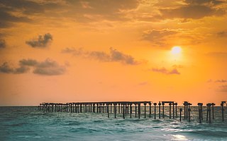
Alappuzha, also known by its former name Alleppey, is the administrative headquarters of Alappuzha District in the Indian State of Kerala. Alappuzha is a city and a municipality in Kerala with an urban population of 174,164 and ranks third among the districts in literacy rate in the State of Kerala. In 2016, the Centre for Science and Environment rated Alappuzha as the cleanest town in India. Alappuzha is considered to be the oldest planned city in this region and the lighthouse built on the coast of the city is the first of its kind along the Laccadive Sea coast.

Chengannur is one of the closest developing municipal towns in the Alappuzha district of the state of Kerala in South India. It is located in the extreme eastern part of the Alappuzha district, on the banks of Pamba River.

Ranni is a small village in the Pathanamthitta district of Kerala, in India. The taluk headquarters is a small township on both sides of the Pamba River. Ranni is also one of the largest taluks in Kerala. The renowned Hindu temple of Sabarimala is in this taluk, situated approximately 66 km from the main town, Ittiyappara. Ranni is known for its natural environment, forests, hills, river and good climate.

New Mahe is a census town in Thalassery taluk of Kannur district in the Indian state of Kerala. It is part of Greater Mahé Region.

Panniyannur is a census town in Talassery taluk of Kannur district in the Indian state of Kerala. It is part of Greater Mahé Region.

Kasaragod([kɑːsɾɡoːɖ] and anglicised to Kassergode is one of the 14 districts in the southern Indian state of Kerala. It is the northernmost district of Kerala and is included in the North Malabar region. It is also known as Saptha Bhasha Sangama Bhoomi, as seven languages namely Malayalam, Tulu, Kannada, Marathi, Konkani, Beary, and Urdu are spoken, unlike the other districts of Kerala. It was a part of the Kannur district of Kerala until 24 May 1984. The district is bounded by Dakshina Kannada district to the north, Western Ghats to the northeast, Kodagu district to the southeast, Kannur district to the south, and Arabian Sea to the west. Kasaragod district has the maximum number of rivers in Kerala - 12.
Azhiyur is a village in Vatakara taluk of Kozhikode district in the state of Kerala, India. Azhiyur is part of Greater Mahé Region. Mahé Railway Station is located in Azhiyur.
Neyyattinkara Taluk is a Taluk (tehsil) in Thiruvananthapuram district in the Indian state of Kerala. It situated in the Southern part of the Thiruvananthapuram district. It comprises 21 villages and one municipality. It is the southernmost taluk in the state.
Thiruvananthapuram Taluk is a Taluk (tehsil) in Thiruvananthapuram district in the Indian state of Kerala. It is the most populous taluk in the district and one of most populous in Kerala. It is situated in the western part of the Thiruvananthapuram district.

Mukundapuram Taluk is a taluk (tehsil) in Irinjalakuda Revenue Division of Thrissur district in the Indian state of Kerala. In 1762 this taluk was formed by Cochin King. When new Chalakudy taluk was formed in 2013 it lost majority of its territory. At present the headquarters of the taluk is Irinjalakuda.and It comprises 29 villages.
- Amballur
- Anandapuram
- Chengallur
- Edathirinji
- Irinjalakkuda
- Kaduppassery
- Kallur
- Karalam
- Karumathra
- Kattur
- Kottanellur
- Madayikonam
- Manavalassery
- Muriyad
- Nellayi
- Nenmanikkara
- Padiyur
- Parappukkara
- Poomangalam
- Porathissery
- Pullur
- Puthenchira
- Thekkumkara
- Thoravu
- Thottippal
- Thrikkur
- Vadakkumkara
- Vallivattam
- Velukkara
Pallikkal is a village in Adoor taluk, Pathanamthitta district in the state of Kerala, India.
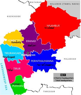
Kondotty Taluk is the seventh taluk (tehsils) in Malappuram district. Kondotty Taluk is declared as the seventh taluk in Malappuram district by chief minister Oommen Chandy on 23 December 2013.

Meenangadi is an old town situated on the highway NH 766 between Kalpetta and Sulthan Bathery in Wayanad District, in Kerala, India. This place is one among the Provinces where the existence of Dolmens provide an historical evidence of earlier civilisation. Coffee bean, Black pepper, Ginger, Rice and Areca are the major crops cultivated in this area. Meenangadi is famous for its Fish Market and Cattle Market. The nearest railway station is at Kozhikode at 87 km and airport is Kannur International Airport with 94 km from Meenangadi. Meenangadi is surrounded by, Ambalavayal Panchayat, Kalpetta Taluk towards west, Gudalur Taluk towards East, Mananthavady Taluk towards west. Kalpetta, Sultan Bathery, Kozhikode are the nearby Cities and towns to Meenangadi.
Kerala's first carbon neutrality project launched in Meenangadi on June 2016. Upon achieving the goals of the project, Meenangadi will be the first village in India to go completely carbon neutral. Meenangadi has a population of 33450 According to 2011 Census with two Villages Purakkadi and (Part)Krishnagiri.

Anthoor is a municipality in the Kannur district of the North Malabar region in the Indian state of Kerala. Anthoor is located roughly 15 km from the Kannur City, and 7 km from Taliparamba town.
Anchampeedika is a town in the Kannur district of the North Malabar region in the Indian state of Kerala. Anchampeedika is located roughly 13.5 km from the Kannur Corporation, and it is adjacent to the Taliparamba municipality.

