Loerie, South Africa

Last updated

Loerie
South Africa Eastern Cape location map.svg
Red pog.svg
Loerie
South Africa adm location map.svg
Red pog.svg
Loerie
Coordinates: 33°52′23″S25°01′48″E / 33.873°S 25.030°E / -33.873; 25.030 Coordinates: 33°52′23″S25°01′48″E / 33.873°S 25.030°E / -33.873; 25.030
Country South Africa
Province Eastern Cape
District Sarah Baartman
Municipality Kouga
Area
[1]
  Total2.77 km2 (1.07 sq mi)
Population
 (2011) [1]
  Total2,787
  Density1,000/km2 (2,600/sq mi)
Racial makeup (2011)
[1]
   Black African 37.7%
   Coloured 59.1%
   Indian/Asian 0.8%
   White 1.7%
  Other0.8%
First languages (2011)
[1]
   Afrikaans 67.0%
   Xhosa 28.2%
   English 2.3%
  Other2.4%
Time zone UTC+2 (SAST)
Postal code (street)
6370
PO box
6370
Area code 042

Loerie (Loerieheuwel is a township situated in Loerie) is a town in Sarah Baartman District Municipality in the Eastern Cape province of South Africa.

Settlement some 25 km north-east of Jeffreys Bay and 11 km north-north-west of the mouth of the Gamtoos River. Said to take its name from the loeries or louries, a turaco species ( Tauraco corythaix ) occurring here. [2]

Loerie had a railway station on the Avontuur Railway which closed in 2011.

In 1930, the Eastern Province Cement Company opened a limestone quarry and built a 14 km cableway to transport the stone to the Loerie railway station where it was transhipped to the Avontuur Railway to be processed in a cement factory near Port Elizabeth. [3]

Related Research Articles

<span class="mw-page-title-main">Ndola</span> City in Copperbelt Province, Zambia

Ndola is the third largest city in Zambia and third in terms of size and population, with a population of 475,194, after the capital, Lusaka, and Kitwe, and the second largest in terms of infrastructure development. It is the industrial and commercial center of the Copperbelt, Zambia's copper-mining region, and capital of Copperbelt Province. It lies just 10 kilometres (6.2 mi) from the border with DR Congo. It is also home to Zambia's first modern stadium, the Levy Mwanawasa Stadium.

<span class="mw-page-title-main">Aliwal North</span> Place in Eastern Cape, South Africa

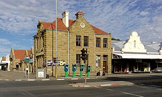
Aliwal North is a town in central South Africa on the banks of the Orange River, Eastern Cape Province. It is a medium-sized commercial centre in the northernmost part of the Eastern Cape.

<span class="mw-page-title-main">South African Class NG G13 2-6-2+2-6-2</span> Class of 12 South African 2–6-2+2-6-2 Garratt locomotives

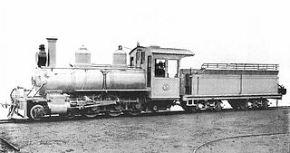
The South African Railways Class NG G13 2-6-2+2-6-2 of 1927 was a narrow gauge articulated steam locomotive.

<span class="mw-page-title-main">South African Class NG15 2-8-2</span> Class of South African narrow-gauge 2-8-2 locomotives

The South African Railways Class NG15 2-8-2 is a class of narrow-gauge steam locomotive.

<span class="mw-page-title-main">Hull and Hornsea Railway</span> Disused railway in the East Riding of Yorkshire, England

The Hull and Hornsea Railway was a branch line which connected the city of Kingston upon Hull with the seaside town of Hornsea in the East Riding of Yorkshire, England.

Railway stations in Mozambique include:

<span class="mw-page-title-main">Avontuur Railway</span> Railway line in South Africa

The Avontuur Railway is a closed railway line between Port Elizabeth and the town of Avontuur in the Western and Eastern Cape provinces of South Africa. It is the longest 610 mm narrow gauge route in the world at a length of 285 kilometres (177 mi). "Avontuur" is the Afrikaans and Dutch word for "adventure".

<span class="mw-page-title-main">Chilanga (Lusaka), Zambia</span> Township of Lusaka, Zambia

Chilanga is a township located 20 km south of Zambia's capital city, Lusaka. It is situated midway between Lusaka and Kafue on the Great North Road.

<span class="mw-page-title-main">South African Class 91-000</span> South African diesel locomotive class

The South African Railways Class 91-000 of 1973 was a narrow-gauge diesel–electric locomotive.

<span class="mw-page-title-main">Joubertina</span> Place in Eastern Cape, South Africa

Joubertina is a small town in the Kou-Kamma Local Municipality, Sarah Baartman District of the Eastern Cape province of South Africa.

<span class="mw-page-title-main">Haarlem, Western Cape</span> Place in Western Cape, South Africa

Haarlem is a settlement in Garden Route District Municipality in the Western Cape province of South Africa.

<span class="mw-page-title-main">South African Class NG8 4-6-0</span> Class of 9 South African narrow-gauge 4–6-0 locomotives

The South African Railways Class NG8 4-6-0 of 1904 was a narrow-gauge steam locomotive from the pre-Union era in the Cape of Good Hope.

<span class="mw-page-title-main">South African Class NG10 4-6-2</span>

The South African Railways Class NG10 4-6-2 of 1916 was a narrow-gauge steam locomotive.

<span class="mw-page-title-main">Two-foot-gauge railways in South Africa</span>

In the early 1900s, 2 ft narrow-gauge railway lines started playing a significant role in South Africa. They facilitated the transport of various agricultural and mineral produce from locations hardly accessible by road. They therefore enabled many communities to become prosperous.

Ogies is a settlement in Nkangala District Municipality in the Mpumalanga province of South Africa. It is a coal-mining town 29 km south-west of Witbank and 70 km north-east of Springs.

<span class="mw-page-title-main">Steinkopf, Northern Cape</span> Place in Northern Cape, South Africa

Steinkopf is a town in Namakwa District Municipality in the Northern Cape province of South Africa.

Addo is a town in Sarah Baartman District Municipality in the Eastern Cape province of South Africa.

<span class="mw-page-title-main">Paterson, South Africa</span> Place in Eastern Cape, South Africa

Paterson is a settlement in Sarah Baartman District Municipality in the Eastern Cape province of South Africa. The town is located some 80 kilometres north-west of Alexandria and 21 kilometres north of Nanaga on the N10 National Route.

<span class="mw-page-title-main">Avontuur</span> Place in Western Cape, South Africa

Avontuur is a town situated in the Garden Route District Municipality in the Western Cape province of South Africa. The town is located 13km south-east of Uniondale on an intersection of the R339 and R62 regional routes.

Krakeel River is a town in Sarah Baartman District Municipality in the Eastern Cape province of South Africa.

References

  1. 1 2 3 4 "Main Place Loerie". Census 2011.
  2. "Dictionary of Southern African Place Names (Public Domain)". Human Science Research Council. p. 279.
  3. http://www.baviaans.net/index.php?page=information&region_id=3&town_id=4 Loerie history