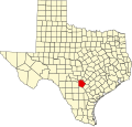
Macdona, Texas

Last updated

Macdona, Texas
Coordinates: 29°19′14″N98°41′50″W / 29.3204655°N 98.6972714°W / 29.3204655; -98.6972714
Country United States
State Texas
County Bexar
Elevation
[1]
630 ft (190 m)
GNIS feature ID2586958 [1]

Macdona is an unincorporated community and census-designated place in Bexar County, Texas, United States. [1] As of the 2010 census, it had a population of 559. [2] Macdona lies along the Union Pacific rail line near Loop 1604 in southwest Bexar County. It is part of the San Antonio Metropolitan Statistical Area.

Contents

History

Macdona was named for George Macdona, an Englishman, who owned the townsite. [3] The first recorded sale of town lots was dated July 7, 1886. [3] The Macdona post office (78054) opened in 1886. On September 1, 1909, the Artesian Belt opened a 42-mile (68 km) line between Macdona and Christine. [4] In 2000, Macdona was reported to have 297 persons. The town is part of the 210 and 726 area code districts.

Demographics

Historical population
CensusPop.Note
2010 559
2020 464−17.0%
U.S. Decennial Census [5]
1850–1900 [6] 1910 [7]
1920 [8] 1930 [9] 1940 [10]
1950 [11] 1960 [12] 1970 [13]
1980 [14] 1990 [15] 2000 [16]
2010 [17] 2020 [18]

Macdona first appeared as a census designated place in the 2010 U.S. Census. [17]

Macdona CDP, Texas – Racial and ethnic composition
Note: the US Census treats Hispanic/Latino as an ethnic category. This table excludes Latinos from the racial categories and assigns them to a separate category. Hispanics/Latinos may be of any race.
Race / Ethnicity (NH = Non-Hispanic)Pop 2010 [19] Pop 2020 [18] % 2010% 2020
White alone (NH)1066818.96%14.66%
Black or African American alone (NH)570.89%1.51%
Native American or Alaska Native alone (NH)010.00%0.22%
Asian alone (NH)350.54%1.08%
Pacific Islander alone (NH)000.00%0.00%
Other race alone (NH)060.00%1.29%
Mixed race or Multiracial (NH)180.18%1.72%
Hispanic or Latino (any race)44436979.43%79.53%
Total559464100.00%100.00%

Climate

The climate in this area is characterized by hot, humid summers and generally mild to cool winters. According to the Köppen Climate Classification system, Macdona has a humid subtropical climate, abbreviated "Cfa" on climate maps. [20]

2004 train derailment and chlorine gas poisoning

On June 28, 2004, a crash between BNSF and Union Pacific Railroad trains in Macdona resulted in the release of 9,400 US gallons (36,000 L; 7,800 imp gal) of liquid chlorine, which immediately vaporized into a cloud of chlorine gas that spread over a radius of at least 700 feet (210 m). Three people, the UP train conductor and two residents, died and at least 40 others were injured. [21]

Related Research Articles

<span class="mw-page-title-main">Cross Mountain, Texas</span> Census-designated place in Texas, United States

Cross Mountain is a census-designated place (CDP) in Bexar County, Texas, United States. The population was 3,944 at the 2020 census, an increase over the figure of 3,124 tabulated in 2010. It is part of the San Antonio Metropolitan Statistical Area.

<span class="mw-page-title-main">Olmito, Texas</span> Census-designated place in Texas, United States

Olmito is a census-designated place (CDP) in Cameron County, Texas, United States. Olmito is Spanish for "little elm". The population was 1,021 at the 2020 census. It is part of the Brownsville–Harlingen Metropolitan Statistical Area. Olmito is the self-described "mesquite capital of the world."

<span class="mw-page-title-main">Heidelberg, Texas</span> Census-designated place in Texas

Heidelberg is a census-designated place (CDP) in Hidalgo County, Texas, United States. The population was 1,507 at the 2020 United States Census. It is part of the McAllen–Edinburg–Mission Metropolitan Statistical Area.

<span class="mw-page-title-main">Linn, Texas</span> Census-designated place in Hidalgo County, Texas, United States

Linn, formerly San Manuel-Linn, is a census-designated place (CDP) in Hidalgo County, Texas, United States. The population was 801 at the 2010 census, down from 958 at the 2000 census. It is part of the McAllen–Edinburg–Mission Metropolitan Statistical Area.

<span class="mw-page-title-main">Tilden, Texas</span> County seat and Census-designated place in Texas, United States

Tilden is an unincorporated community, census-designated place (CDP), and the county seat of McMullen County, Texas, United States. The population was 190 at the 2020 census.

<span class="mw-page-title-main">Guthrie, Texas</span> Census-designated place in Texas, US

Guthrie is an unincorporated town and census-designated place (CDP) in, and the county seat of, King County in the U.S. state of Texas. It is in the northern part of the state, 93 miles (150 km) east of Lubbock and 117 miles (188 km) west of Wichita Falls. It serves as the principal headquarters of the Four Sixes Ranch. As of the 2020 census, its population was 151, down from 160 at 2010.

<span class="mw-page-title-main">Montague, Texas</span> Census-designated place in Texas, US

Montague is a census-designated place and unincorporated community in Montague County, Texas, United States. It is the county seat of Montague County and had an estimated population of 400 in 2000, according to the Handbook of Texas. Its population was 304 as of the 2010 census.

<span class="mw-page-title-main">Kopperl, Texas</span> Place in Texas, United States

Kopperl is an unincorporated community and census designated place (CDP) in Bosque County, Texas, United States. It lies on the northwestern end of Lake Whitney, and has an estimated population of 225.

Wadsworth is an unincorporated community in Matagorda County, Texas, United States. According to the Handbook of Texas, the community had an estimated population of 180 in 2000.

<span class="mw-page-title-main">Neches, Texas</span> Place in Texas, United States


Neches is an unincorporated community and census designated place (CDP) in east central Anderson County, in the U.S. state of Texas. According to the Handbook of Texas, the community had a population of 175 in 2000. It is located within the Palestine, Texas micropolitan area.

Richards is an unincorporated community and census-designated place (CDP) in eastern Grimes County, Texas, United States. The community is located on Farm roads 1486 and 149. The Chicago, Rock Island and Pacific Railroad line passes the east side of the community and Lake Creek flows past to the east.

<span class="mw-page-title-main">Dime Box, Texas</span> Place in Texas, United States

Dime Box is an unincorporated community and census designated place in Lee County, Texas, United States. The Dime Box Independent School District serves area students and home to the Dime Box High School Longhorns. It is named after what is now called Old Dime Box.

<span class="mw-page-title-main">Lingleville, Texas</span> Census-designated place in Erath County, Texas, United States

Lingleville is a census-designated place (CDP) in Erath County, Texas, United States. Lingleville is located at the intersection of Farm to Market Road 8 and Farm to Market Road 219, 10 miles (16 km) west of Stephenville.

<span class="mw-page-title-main">McDade, Texas</span> Census-designated place in Bastrop County, Texas, United States

McDade is a census-designated place (CDP) in northern Bastrop County, Texas, United States, located along U.S. Route 290. As of the 2020 census, it had a population of 720. It is 9 miles (14 km) east of Elgin and 34 miles (55 km) east of Austin. It is 21 miles (34 km) west of Giddings.

Banquete is a census-designated place (CDP) in Nueces County, Texas, United States. Banquete is located at the intersection of State Highway 44 and FM 666, 23 miles west of Corpus Christi. Banquete should not be confused with Rancho Banquete, a census-designated place situated several miles west of the community.

Aguilares is a census-designated place (CDP) in Webb County, Texas, United States. This was a new CDP for the 2010 census, with a population of 21. The population in the 2020 U.S. Census declined to 6.

<span class="mw-page-title-main">Briggs, Texas</span> Census-designated place in Burnet County, Texas, United States

Briggs is an unincorporated community and census-designated place (CDP) in eastern Burnet County, Texas, United States.

<span class="mw-page-title-main">Rosanky, Texas</span> Census-designated place in Bastrop County, Texas, United States

Rosanky is a census designated place (CDP) located on Farm to Market Road 535 in southern Bastrop County, Texas, United States. Rosanky has a post office, with the ZIP code 78953. The town is named for Ed Rosanky, who emigrated from Prussia and settled in the area in 1854.

Proctor is an unincorporated community and census-designated place (CDP) in Comanche County, Texas, United States. According to the Handbook of Texas, the community had an estimated population of 220 in 2000.

Burlington is an unincorporated community and census-designated place in Milam County, Texas, United States. It was first listed as a CDP in the 2020 census, with a population of 81. Burlington has a post office, with the postal ("ZIP") code 76519.

References

  1. 1 2 3 U.S. Geological Survey Geographic Names Information System: Macdona, Texas
  2. "Geographic Identifiers: 2010 Demographic Profile Data (G001): Macdona CDP, Texas". U.S. Census Bureau, American Factfinder. Archived from the original on February 12, 2020. Retrieved April 15, 2014.
  3. 1 2 Handbook of Texas Online - MACDONA, TX
  4. Handbook of Texas Online – ARTESIAN BELT RAILROAD
  5. "Decennial Census by Decade". United States Census Bureau .
  6. "1900 Census of Population - Population of Texas By Counties And Minor Civil Divisions" (PDF). United States Census Bureau .
  7. "1910 Census of Population - Supplement for Texas" (PDF). United States Census Bureau .
  8. "1920 Census of Population - Number of Inhabitants - Texas" (PDF). United States Census Bureau .
  9. "1930 Census of Population - Number of Inhabitants - Texas" (PDF). United States Census Bureau .
  10. "1940 Census of Population - Number of Inhabitants - Texas" (PDF). United States Census Bureau .
  11. "1950 Census of Population - Number of Inhabitants - Texas" (PDF). United States Census Bureau .
  12. "1960 Census of Population - Number of Inhabitants - Texas" (PDF). United States Census Bureau .
  13. "1970 Census of Population - Number of Inhabitants - Texas" (PDF). United States Census Bureau .
  14. "1980 Census of Population - Number of Inhabitants - Texas" (PDF). United States Census Bureau .
  15. "1990 Census of Population - Population and Housing Unit Counts - Texas" (PDF). United States Census Bureau .
  16. "2000 Census of Population - Population and Housing Unit Counts - Texas" (PDF). United States Census Bureau .
  17. 1 2 "2010 Census of Population - Population and Housing Unit Counts - Texas" (PDF). United States Census Bureau .
  18. 1 2 "P2 Hispanic or Latino, and Not Hispanic or Latino by Race – 2020: DEC Redistricting Data (PL 94-171) – Macdona CDP, Texas". United States Census Bureau .
  19. "P2 Hispanic or Latino, and Not Hispanic or Latino by Race – 2010: DEC Redistricting Data (PL 94-171) – Macdona CDP, Texas". United States Census Bureau .
  20. Climate Summary for Macdona, Texas
  21. Collision of Union Pacific Railroad train MHOTU-23 with BNSF Railway Company train MEAP-TUL-126-D with subsequent derailment and hazardous materials release, Macdona, Texas, June 28, 2004 (PDF). United States National Transportation Safety Board. 2006. OCLC   75276300.