
The Barossa Valley is a valley in South Australia located 60 kilometres (37 mi) northeast of Adelaide city centre. The valley is formed by the North Para River. It is notable as a major wine-producing region and tourist destination.

The Murrumbidgee River is a major tributary of the Murray River within the Murray–Darling basin and the second longest river in Australia. It flows through the Australian state of New South Wales and the Australian Capital Territory, descending 1,500 metres (4,900 ft) over 1,485 kilometres (923 mi), generally in a west-northwesterly direction from the foot of Peppercorn Hill in the Fiery Range of the Snowy Mountains towards its confluence with the Murray River near Boundary Bend.

The Darling River is the third-longest river in Australia, measuring 1,472 kilometres (915 mi) from its source in northern New South Wales to its confluence with the Murray River at Wentworth, New South Wales. Including its longest contiguous tributaries it is 2,844 km (1,767 mi) long, making it the longest river system in Australia. The Darling River is the outback's most famous waterway.

Sturt Highway is an Australian national highway in New South Wales, Victoria, and South Australia. It is an important road link for the transport of passengers and freight between Sydney and Adelaide and the regions situated adjacent to the route.

Barossa Valley Way is the main road linking most of the major towns of the Barossa Valley in South Australia, designated as route B19 for its entire length. It is 35 km long, roughly following the North Para River.

The Loddon River, an inland river of the north–central catchment, part of the Murray-Darling basin, is located in the lower Riverina bioregion and Central Highlands and Loddon Mallee regions of the Australian state of Victoria. The headwaters of the Loddon River rise on the northern slopes of the Great Dividing Range east of Daylesford and descend to flow north into the Little Murray River, near Swan Hill. The river is impounded by the Cairn Curran and Laanecoorie reservoirs. The Tullaroop Creek tributary, which joins just above Laanecoorie Reservoir, is impounded by the Tullaroop Reservoir (72,950ML).
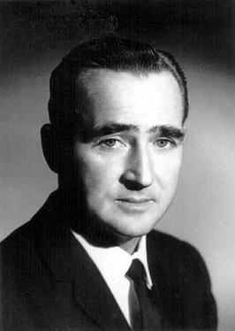
Colin Milton Thiele AC was an Australian author and educator. He was renowned for his award-winning children's fiction, most notably the novels Storm Boy, Blue Fin, the Sun on the Stubble series, and February Dragon. As Vice Principal and Principal of Wattle Park Teachers College and Principal of Murray Park CAE for much of the 1960s and 70s he had a significant impact on teacher education in South Australia.

The Mount Lofty Ranges are a range of mountains in the Australian state of South Australia which for a small part of its length borders the east of Adelaide. The part of the range in the vicinity of Adelaide is called the Adelaide Hills and defines the eastern border of the Adelaide Plains.

Barossa Reservoir is a reservoir in the Australian state of South Australia, built between 1899 and 1902 to supply water to Gawler and other northern country areas. Built at a cost of almost A£170,000 the reservoir was hailed on completion as an engineering marvel, and with the reservoir wall rising to a height of 36 metres (118 ft), it was, at the time of its completion, the highest dam wall in Australia.

The Onkaparinga River, known as Ngangkiparri or Ngangkiparingga in the Kaurna language, is a river located in the Southern Adelaide region in the Australian state of South Australia. Rising in the Mount Lofty Ranges, the river's estuary extends from Old Noarlunga to the river's mouth between the suburbs of Port Noarlunga and Port Noarlunga South.

Eudunda is a rural town in South Australia, roughly 103 kilometres northeast of Adelaide, established in 1870 after settlers began moving into the area in the 1860s. As of the 2006 census, Eudunda had a population of 640.

The South Australian wine industry is responsible for more than half the production of all Australian wine. South Australia has a vast diversity in geography and climate which allows the state to be able to produce a range of grape varieties–from the cool climate Riesling variety in the Clare Valley wine region to the big, full bodied Shiraz wines of the Barossa Valley.
Bredbo River, a perennial stream that is part of the Murrumbidgee catchment within the Murray–Darling basin, is located in the Monaro region of New South Wales, Australia.

Black Hill is a settlement in South Australia. Black Hill is between the Mount Lofty Ranges and the Murray River on the banks of the Marne River. Until 1918, when many place names were changed if they sounded German, Black Hill was known as Friedensthal.

The Barossa Valley wine region is one of Australia's oldest and most premier wine regions. Located in South Australia, the Barossa Valley is about 56 km northeast of the city of Adelaide. Unlike most of Australia whose wine industry was heavily influenced by the British, the wine industry of the Barossa Valley was founded by German settlers fleeing persecution from the Prussian province of Silesia. The warm continental climate of the region promoted the production of very ripe grapes that was the linchpin of the early Australian fortified wine industry. As the modern Australian wine industry shifted towards red table wines in the mid-20th century, the Barossa Valley fell out of favor due to its reputation for being largely a Syrah from producers whose grapes were destined for blending. During this period the name "Barossa Valley" rarely appeared on wine labels. In the 1980s, the emergence of several boutique families specializing in old vine Shiraz wines began to capture international attention for the distinctive style of Barossa Shiraz, a full bodied red wine with rich chocolate and spice notes. This led to a renaissance in the Barossa Valley which catapulted the region to the forefront of the Australian wine industry.

The Light River, commonly called the River Light, is a seasonal and significant river in the Mid North region of the Australian state of South Australia named for early surveyor William Light.

The Campaspe River, an inland intermittent river of the north–central catchment, part of the Murray-Darling basin, is located in the lower Riverina bioregion and Central Highlands and Wimmera regions of the Australian state of Victoria. The headwaters of the Campaspe River rise on the northern slopes of the Great Dividing Range and descend to flow north into the Murray River, Australia's longest river, near Echuca.

Mount Lofty Ranges zone is a wine zone located in South Australia west of the Murray River that occupies the Adelaide metropolitan area north of Glenelg, extending as far north as Crystal Brook, and as far south as Mount Compass in the Mount Lofty Ranges. The zone which encloses the Barossa zone on three sides, includes three wine regions that have received appellation as Australian Geographical Indications (AGIs): Adelaide Hills, Adelaide Plains and Clare Valley. The zone received AGI in 1996.
Barossa zone is a wine zone located in central South Australia west of the Murray River and which occupies the Barossa Valley, the Eden Valley and some adjoining land. The zone which is enclosed by the Mount Lofty Ranges zone on three sides and by the Lower Murray zone to its east, contains two wine regions which have received appellation as Australian Geographical Indications (AGI). These are the Barossa Valley and Eden Valley regions. The Barossa zone also includes a broader area around these two defined regions. The zone received AGI in 1996.
In South Australia, one of the states of Australia, there are many areas which are commonly known by regional names. Regions are areas that share similar characteristics. These characteristics may be natural such as the Murray River, the coastline, desert or mountains. Alternatively, the characteristics may be cultural, such as common land use. South Australia is divided by numerous sets of regional boundaries, based on different characteristics. In many cases boundaries defined by different agencies are coterminous.
