
The South Island, also officially named Te Waipounamu, is the larger of the two major islands of New Zealand in surface area, the other being the smaller but more populous North Island. It is bordered to the north by Cook Strait, to the west by the Tasman Sea, and to the south and east by the Pacific Ocean. The South Island covers 150,437 square kilometres (58,084 sq mi), making it the world's 12th-largest island. At low altitude, it has an oceanic climate.
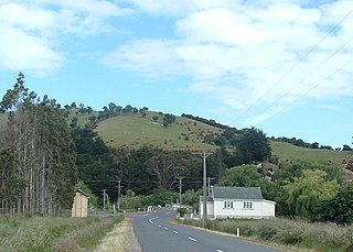
Henley is a township on New Zealand's Taieri Plains, named after the rowing centre Henley-on-Thames in England. It lies close to the confluence of the Taieri and Waipori Rivers at the eastern edge of the plain, at the foot of a low range of coastal hills. The township lies close to the ecologically significant Sinclair Wetlands, which lie 3.5 kilometres (2.2 mi) to the west.
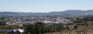
Mosgiel is an urban satellite of Dunedin in Otago, New Zealand, fifteen kilometres west of the city's centre. Since the re-organisation of New Zealand local government in 1989 it has been inside the Dunedin City Council area. Mosgiel has a population of approximately 14,500 as of June 2022. The town celebrates its location, calling itself "The pearl of the plain". Its low-lying nature does pose problems, making it prone to flooding after heavy rains. Mosgiel takes its name from Mossgiel Farm, Ayrshire, the farm of the poet Robert Burns, the uncle of the co-founder in 1848 of the Otago settlement, the Reverend Thomas Burns.

Milton, formerly known as Tokomairiro or Tokomairaro, is a town of over 2,000 people, located on State Highway 1, 50 kilometres to the south of Dunedin in Otago, New Zealand. It lies on the floodplain of the Tokomairaro River, one branch of which loops past the north and south ends of the town. This river gives its name to many local features, notably the town's only secondary school, Tokomairiro High School.
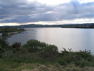
Lake Waihola is a 640 ha tidal freshwater lake located 15 km north of Milton in Otago, in New Zealand's South Island. Its area is some 9 square kilometres, with a maximum length of 6 kilometres and a mean depth of 0.75m.
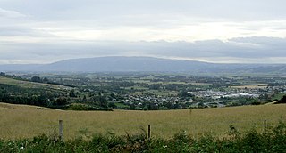
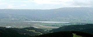
The Taieri Plain is an area of fertile agricultural land to the southwest of Dunedin, in Otago, New Zealand. The plain covers an area of some 300 square kilometres, with a maximum extent of 30 kilometres. It is not to be confused with Strath Taieri, a second plain of the Taieri River, 40kms to the north beyond Mount Ross.

The Tokomairaro River is located in Otago, New Zealand. It flows southeast for some 50 kilometres (30 mi), reaching the Pacific Ocean at Toko Mouth 50 kilometres (30 mi) south of Dunedin. The town of Milton is located on the Tokomairaro's floodplain, close to the junction of its two main branches.

The Waipori River is in Otago in the South Island of New Zealand. Rising in the Lammerlaw Range, it flows southeast for 50 kilometres (31 mi) before joining the Taieri River near Henley, 30 kilometres (19 mi) southwest of Dunedin of which it is officially the southernmost border. Google Maps erroneously shows the stretch of Taieri river from the confluence to the mouth as Waipori River. The correct name is shown on the New Zealand government's official NZ Topo Map.
South Otago lies in the south east of the South Island of New Zealand. As the name suggests, it forms the southernmost part of the geographical region of Otago.

Taieri Mouth is a small fishing village at the mouth of the Taieri River, New Zealand. Taieri Island (Moturata) lies in the ocean several hundred metres off the river's mouth.
Lake Waipori is the smaller and shallower of the pair of lakes located in the wetlands to the south west of Dunedin in New Zealand on the Waipori River. The Waipori River is a major tributary of the Taieri River, and these wetlands form the southern edge of the Taieri Plains.

Clutha District is a local government district of southern New Zealand, with its headquarters in the Otago town of Balclutha. The Clutha District has a land area of 6,334.47 km2 (2,445.75 sq mi) and an estimated population of 18,650 as of June 2022. Clutha District occupies the majority of the geographical area known as South Otago.

The Southern Scenic Route is a tourist highway in New Zealand linking Queenstown, Fiordland, Te Anau and the iconic Milford Road to Dunedin via, Riverton, Invercargill and The Catlins. An Australian travel magazine labelled it "one of the world's great undiscovered drives" in 2008.

State Highway 8 is one of New Zealand's eight national highways. It forms an anticlockwise loop through the southern scenic regions of the Mackenzie Basin and Central Otago, starting and terminating in junctions with State Highway 1. Distances are measured from north to south.

Saddle Hill is a prominent landmark overlooking the northeastern end of the Taieri Plains in Otago, New Zealand. Within the limits of Dunedin city, it is located 18 kilometres to the west of the city centre, between Mosgiel and Green Island, and is clearly visible from many of the city's southern hill suburbs. A lookout on the northern slopes of the hill commands a good view across the plains, with Lake Waihola visible 25 kilometres to the west in clear weather.
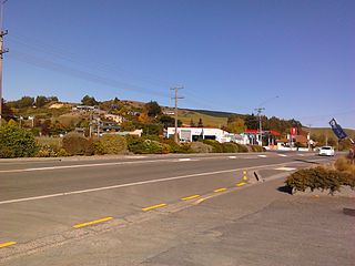
The township of Waihola lies between Dunedin and Milton, New Zealand in Otago, in New Zealand's South Island. It lies close to the southeast shore of the shallow tidal lake which shares its name.

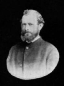
Captain Joseph Thomas (1803–?) was a British explorer and the chief surveyor for Lyttelton, Sumner and Christchurch in New Zealand. He took up surveying after service in the British army, gaining the rank of lieutenant. In the 1840s, he explored many parts of New Zealand and worked for the New Zealand Company. This gained him employment with the Canterbury Association, which sent him to New Zealand in 1848. Thomas' role was to find a suitable site for their proposed settlement, and what became the Canterbury region with Christchurch as its capital was the result of his efforts. He was dismissed in early 1851 over quarrels with John Robert Godley, the agent of the Canterbury Association, just after the first settlers had arrived in the colony. Thomas' life after 1853 is unknown. Having allowed for Hagley Park as a generous central city green space is regarded as his major achievement, and it is his lasting legacy.
William Henry Valpy Jr. was one of the earliest settlers of Otago.
The April 1865 Bruce by-election was a New Zealand by-election held in the multi-member electorate of Bruce during the 3rd New Zealand Parliament on 8 April 1865. It was triggered on 9 January that year by the resignation of separationist Thomas Gillies and won by prominent settler Arthur John Burns. The more liberal businessman William John Dyer was the sole other contester of the by-election, finishing with 43.33% of the vote.
Moneymore is a small farming community in South Otago, New Zealand. It is located 5 kilometres to the southwest of Milton, to the south of SH 1.

