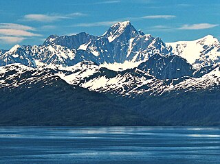
Mount Gilbert is a prominent 9,638-foot (2,938 m) glaciated mountain summit located in the Chugach Mountains, in the U.S. state of Alaska. The peak is situated 54 mi (87 km) east of Anchorage, 32 mi (51 km) northeast of Whittier, and 5.8 mi (9 km) northeast of Mount Muir, on land managed by Chugach National Forest. Although modest in elevation, relief is significant since the mountain rises up from tidewater at Harriman Fjord in Prince William Sound in less than six miles.

Horn Spire is a 6,700+ ft mountain summit located in the Boundary Ranges of the Coast Mountains, in the U.S. state of Alaska. The peak is situated between the Thiel Glacier and Battle Glacier at the northwest extent of the Juneau Icefield, 31 mi (50 km) north-northwest of Juneau, Alaska, and 12 mi (19 km) east of Lynn Canal, on land managed by Tongass National Forest. Horn Spire is the highest point of the Icefall Spires, and although modest in elevation, relief is significant since the north face of the mountain rises over 4,700 feet above the Thiel Glacier in less than one mile. The peak's descriptive name was submitted in 1965 by Maynard Miller, director of the Juneau Icefield Research Project, and officially adopted that same year by the U.S. Board on Geographic Names. The first ascent of the peak was made June 30, 1973, by Dick Benedict, Gerry Buckley, Craig Lingle, and Bruce Tickell.

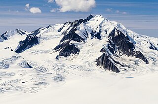
Mount Huxley is a 12,216-foot glaciated mountain summit located in the Saint Elias Mountains of Wrangell-St. Elias National Park and Preserve, in the U.S. state of Alaska. The remote peak is situated 75 mi (121 km) northwest of Yakutat, and 8.7 mi (14 km) west-northwest of Mount Saint Elias. The peak rises above the Columbus Glacier and Bagley Icefield to its north, the Tyndall Glacier to the south, and the Yahtse Glacier to the west. Precipitation runoff from the mountain drains into the Gulf of Alaska. The mountain was named in 1886 by English mountaineer Harold Ward Topham for Thomas Henry Huxley (1825-1895), an English biologist. The mountain was officially named Huxley Peak in 1917, but the name was officially changed to Mount Huxley in 1968 by the U.S. Board on Geographic Names. The first ascent of the peak was made June 9, 1996 by Paul Claus who landed his plane at 11,500 feet elevation on the western flank and climbed the remaining distance to the summit. The second ascent of Mt. Huxley, and first complete ascent from base to summit, was made in June 2018 by Scott Peters, Andrew Peter, and Ben Iwrey starting from the Columbus Glacier.
Andy Simons Mountain is a prominent 6,407-foot (1,953 m) double summit mountain located in the Kenai Mountains, and the fourth-highest peak on the Kenai Peninsula in the state of Alaska. The true summit is 1.3 mile west of the 5,300+ foot subsidiary east peak on this five-mile-long northwest-to-southeast trending mountain. The mountain is situated in Chugach National Forest, 7.2 mi (12 km) east of Mount Adair, and 17 mi (27 km) north of Seward, Alaska. The Seward Highway and Alaska Railroad traverse its western foot. Precipitation runoff from the mountain drains into Kenai Lake.

Split Thumb is a 5,523 ft (1,680 m) glaciated mountain summit located in the Boundary Ranges of the Coast Mountains, in the U.S. state of Alaska. The peak is situated near the southern periphery of the Juneau Icefield, 9 mi (14 km) northeast of Juneau, 2.15 mi southeast of Nugget Mountain, and 4 mi (6 km) east of Heintzleman Ridge, on land managed by Tongass National Forest. Split Thumb is surrounded by the Lemon Creek Glacier to the west, and Norris Glacier to east. The Split Thumb Icefall is set on the east aspect of the peak. This peak's descriptive name was published in 1951 by the U.S. Geological Survey. The first ascent of Split Thumb was made July 2, 1954, by a Juneau Icefield Research Project party comprising Edward LaChapelle, Dick Hubley, Carlton Ray, Dr. Conrad Buettner, and Bob Goodwin.
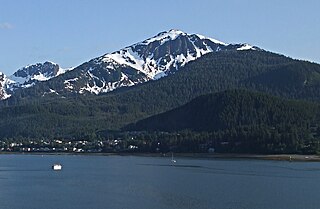
Mount Bradley is a 3,337-foot (1,017 m) elevation mountain summit located on Douglas Island in the Alexander Archipelago, in the U.S. state of Alaska. It is the third-highest peak on the island, and is situated 4 mi (6 km) south of Juneau, on land managed by Tongass National Forest. Although modest in elevation, relief is significant since the peak rises up from tidewater of Gastineau Channel in approximately two miles. Its nearest higher neighbor is Mount Ben Stewart, 5.6 mi (9 km) to the northwest.

Citadel Peaks is a mountain ridge located in the Goat Haunt area of Glacier National Park, in Glacier County of the U.S. state of Montana. This arête with a row of sharp points is part of the Livingston Range, and is approximately four miles east of the Continental Divide. Neighbors include Olson Mountain, two miles (3.2 km) to the north, Mount Cleveland four miles (6.4 km) to the east, and Kootenai Peak 2.7 miles (4.3 km) to the south. Topographic relief is significant as Citadel Peaks rises over 3,800 feet above Waterton Lake in less than two miles, and 3,000 feet above Lake Janet in one mile. Precipitation runoff from the mountain drains to the south end of Waterton Lake. The first ascent of Citadel Spire, a major pinnacle on the ridge, was made in 1967 by Jerry Kanzler, Jim Kanzler, Ray Martin, and Clare Pogreba. This geographical feature's name was officially adopted in 1929 by the United States Board on Geographic Names. To the Pikuni people, Citadel Peaks is known as "Ataniawxis", meaning "The Needles".
Mount Leeper is a 9,603-foot-elevation (2,927-meter) mountain summit in Alaska, United States.

Mount Emmerich is a 6,877-foot-elevation (2,096-meter) mountain summit in Alaska.
The Tusk is a 6,650-foot-elevation (2,027-meter) mountain summit in Alaska, United States.

Mount Gerdine is an 11,258-foot-elevation (3,431-meter) mountain summit in Alaska.

Mount Bagot is a 2,181-metre (7,156-foot) mountain summit located on, and in part defining, the international border between British Columbia, Canada, and Alaska, United States.

Mount Doonerak is a 7,457-foot-elevation (2,273-meter) mountain summit in Alaska, United States.

Mount Geist is a 10,716-foot-elevation (3,266-meter) mountain summit in Alaska, United States.

Mount Adolph Knopf is a 6,200-foot-elevation (1,890-meter) glaciated mountain summit located in the Boundary Ranges of the Coast Mountains, in the U.S. state of Alaska. It is situated 28 miles (45 km) north-northwest of Juneau to the western side of the Juneau Icefield, on land managed by Tongass National Forest. Topographic relief is significant as the summit rises 2,200 feet (670 m) above the Eagle Glacier in 0.5 mi (0.80 km) and 3,800 feet (1,158 m) above the Thiel Glacier in 1.25 mi (2.01 km). Precipitation runoff from the mountain's slopes drains to Lynn Canal.

Glacier King is a 6,500-foot-elevation (1,981-meter) mountain summit in Alaska, United States.
Mount Ogilvie is a 7,867-foot-elevation (2,398-meter) mountain summit located on, and in part defining, the international border between Alaska, United States, and British Columbia, Canada.

Mount Leland is a 7,810-foot-elevation (2,380-meter) glaciated mountain summit located in the Boundary Ranges of the Coast Mountains, in the U.S. state of Alaska. It is situated 27 miles (43 km) southeast of Skagway along the western edge of the Juneau Icefield, on land managed by Tongass National Forest. Topographic relief is significant as the summit rises 4,400 feet (1,340 m) above the Meade Glacier in 1.25 mi (2.01 km). Precipitation runoff and glacial meltwater from the mountain drains to Lynn Canal via the Katzehin River. Mount Leland's toponym was officially adopted in 1972 by the U.S. Board on Geographic Names to commemorate surveyor Ora Miner Leland (1876–1962), who led the International Boundary Commission Party of 1907. The peak rises a little over four miles (6.4 km) from the US–Canada boundary.

Observation Peak is a 4,931-foot (1,503 m) mountain summit located in the Boundary Ranges of the Coast Mountains, in the U.S. state of Alaska. The peak is situated 4.5 miles (7.2 km) northeast of Juneau along the southern periphery of the Juneau Icefield, on land managed by Tongass National Forest. Precipitation runoff and glacial meltwater from the mountain drains to Gastineau Channel via Lemon and Salmon creeks, whereas the southeast slope drains to Taku Inlet via Carlson Creek. Although modest in elevation, relief is significant as the summit rises over 3,700 feet (1,128 m) above Salmon Creek Reservoir in 1.6 miles (2.6 km). This peak's local name was published in 1962 by the U.S. Geological Survey and the toponym has been officially adopted by the U.S. Board on Geographic Names.

Table Mountain is an 11,069-foot-elevation (3,374-meter) mountain summit in Park County, Wyoming, United States.


