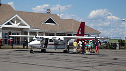
New England Airlines

Last updated
New England Airlines
New England Airlines logo.jpg
IATA ICAO Callsign
EJNEANEW ENGLAND
Founded1970
AOC # NEAA703G [1]
Operating bases Westerly State Airport
Fleet size7
Destinations2
Parent company New England Airlines, Inc.
Headquarters Westerly, Rhode Island
Key peopleWilliam Bendokas (President)
Website blockislandsairline.com
New England Airlines Islander at Block Island State Airport 7-23-2015.jpg

New England Airlines is a regional airline based in Westerly, Rhode Island, USA. With a main base at Westerly State Airport, it provides scheduled service to Block Island and operates charters to other airports along the Northeast coast.

Contents

History

The airline was established and started operations in 1970. [2] New England Airlines has been in continuous service since then, under the same private ownership. It was and is the only scheduled airline with its primary bases of operation in Rhode Island. This was designed to fulfill the loss of service from a short-lived airline called Viking Airways, which folded in the 1960s. [3]

The airline is noted for its provision of cargo delivery services, including Chinese food (and other restaurant orders) delivered from the mainland to the Block Island airport in as little as 90 minutes. [4] The airline only has a half dozen pilots during the winter and over a dozen during the summertime. According to the owner, half of the business comes from charter requests for business workers in the New York area and other locations along the northeast coast. [3]

Destinations for scheduled flights

CityAirportIATA CodeDestinationsNotes
Flag of Rhode Island.svg Rhode Island
New Shoreham Block Island State Airport BIDWesterly
Westerly Westerly State Airport WSTBlock Island

Fleet

The New England Airlines fleet consists of the following aircraft: [5] [2]

New England Airlines fleet
AircraftIn fleetOrdersNotes
Britten-Norman BN-2 Islander 30
PA-32-300 Cherokee Six 30
PA-28-180 Archer 10
Total70-

Accidents

Related Research Articles

<span class="mw-page-title-main">Westchester County Airport</span> Public airport in Westchester County, New York

Westchester County Airport is a county-owned airport in Westchester County, New York, three miles (6 km) northeast of downtown White Plains, with territory in the towns of North Castle and Harrison, New York, and village of Rye Brook, New York. It is sometimes referred to as the White Plains Airport and is so identified by the Official Airline Guide (OAG).

<span class="mw-page-title-main">Bradley International Airport</span> Airport near Hartford, Connecticut, USA

Bradley International Airport is a public international airport in Windsor Locks, Connecticut, United States. Owned and operated by the Connecticut Airport Authority, it is the second-largest airport in New England.

<span class="mw-page-title-main">Aeroméxico Flight 498</span> 1986 mid-air aircraft collision and crash in Cerritos, California, US

Aeroméxico Flight 498 was a scheduled commercial flight from Mexico City, Mexico to Los Angeles, California, United States, with several intermediate stops. On Sunday, August 31, 1986, the McDonnell Douglas DC-9 operating the flight was clipped in the tail section by N4891F, a Piper PA-28-181 Cherokee owned by the Kramer family, and crashed into the Los Angeles suburb of Cerritos, killing all 64 on the DC-9, all three on the Piper and an additional 15 on the ground. Eight on the ground also sustained minor injuries. Blame was assessed equally on the Federal Aviation Administration (FAA) and the pilot of the Cherokee. No fault was found with the DC-9 or the actions of its crew.

<span class="mw-page-title-main">Corporate Airlines Flight 5966</span> 2004 aviation accident

Corporate Airlines Flight 5966 was a scheduled passenger flight from St. Louis, Missouri, to Kirksville, Missouri. On October 19, 2004, the Jetstream 32 operating the flight crashed on approach to Kirksville Regional Airport due to pilot error. Thirteen people were killed.

<span class="mw-page-title-main">Green Bay–Austin Straubel International Airport</span> Airport serving Green Bay, Wisconsin, USA

Green Bay–Austin Straubel International Airport is a county-owned public-use airport in Brown County, Wisconsin, United States, which serves Northeastern Wisconsin. It is the fourth busiest of eight commercial service airports in Wisconsin in terms of passengers served. The airport is located 7 nautical miles southwest of downtown Green Bay, in the village of Ashwaubenon. It is included in the Federal Aviation Administration (FAA) National Plan of Integrated Airport Systems for 2021–2025, in which it is categorized as a non-hub primary commercial service facility. The airport sits on portions of land encompassing Green Bay and the Oneida Nation of Wisconsin's Indian reservation. It has two runways and is used for commercial air travel and general aviation. There are two concourses with six gates each. The airport is named for Lt. Col. Austin Straubel, the first aviator from Brown County to die in his country's service on 3 February 1942, after having served for thirteen years in the United States Army Air Corps. The airport name was officially changed to Green Bay–Austin Straubel International Airport on 17 August 2016.

<span class="mw-page-title-main">Presque Isle International Airport</span> Airport

Presque Isle International Airport, formally Northern Maine Regional Airport at Presque Isle, is a mile northwest of Presque Isle, in Aroostook County, Maine, United States. It serves the residents of Presque Isle and a vast area of northern Maine and northwestern New Brunswick. Airline flights to Newark Liberty International Airport are subsidized by the federal government's Essential Air Service program at a cost of $3,892,174.

<span class="mw-page-title-main">Wilkes-Barre/Scranton International Airport</span> Airport in Pittston Township, Pennsylvania

Wilkes-Barre/Scranton International Airport is mostly in Pittston Township, Pennsylvania, and spans the border between Luzerne County and Lackawanna County. It is owned and operated by the two counties; it is about 7 miles from Scranton and 8 miles from Wilkes-Barre. It is the fifth largest airport in Pennsylvania by passenger count and calls itself "your gateway to Northeastern Pennsylvania and the Pocono Mountains".

<span class="mw-page-title-main">American Airlines Flight 625</span> 1976 aviation accident

American Airlines Flight 625, a Boeing 727-100, crashed at St. Thomas, U.S. Virgin Islands on April 27, 1976, while on a domestic scheduled passenger flight originating at T. F. Green Airport in Rhode Island and ending at Saint Thomas, United States Virgin Islands, with an intermediate stop at John F. Kennedy International Airport. 37 out of the 88 passengers on board died in the accident.

<span class="mw-page-title-main">Dubuque Regional Airport</span> Airport

Dubuque Regional Airport is a regional airport located eight miles south of Dubuque, in Dubuque County, Iowa. On U.S. Highway 61, the airport is owned by the city of Dubuque and is operated as a department of the city government. The city council appoints people for four-year terms to the Airport Commission board, which oversees the airport. For day-to-day operations, the Commission hires an airport manager. DBQ is used for general aviation and sees one airline. A charter service is run by Sun Country Airlines. The airport offers maintenance and refueling services, including service for jets.

Ameriflight LLC is an American cargo airline with headquarters at the Dallas/Fort Worth International Airport. It is the largest United States FAA Part 135 cargo carrier, operating scheduled and contract cargo services from 19 bases to destinations in 250 cities across 43 US states as well as in Canada, Mexico, the Caribbean, and South America. Ameriflight serves major financial institutions, freight forwarders, laboratories, and overnight couriers in the US, and provides feeder services for overnight express carriers nationwide and internationally. Ameriflight averages 525 daily departures with over 100,000 combined flight hours annually and a 99.5% on-time performance. Ameriflight employs over 700 people.

<span class="mw-page-title-main">Portsmouth International Airport at Pease</span> Airport in New Hampshire, USA

Portsmouth International Airport at Pease, formerly known as Pease International Airport, is a joint civil and military use airport located one nautical mile (2 km) west of the central business district of Portsmouth, a city in Rockingham County, New Hampshire, United States. It is owned by the Pease Development Authority. It is included in the Federal Aviation Administration (FAA) National Plan of Integrated Airport Systems for 2017–2021, in which it is categorized as a non-hub primary commercial service facility.

Newport State Airport is a state-owned public-use airport in Newport County, Rhode Island, United States. It serves the city of Newport and is located 2 nmi northeast of its central business district. This airport is included in the National Plan of Integrated Airport Systems for 2011–2015, which categorized it as a general aviation facility. There is no scheduled airline service available, but it once was served by Air New England.

<span class="mw-page-title-main">Pellston Regional Airport</span> Airport

Pellston Regional Airport, also known as Pellston Regional Airport of Emmet County, is a public airport located one mile (1.6 km) northwest of the central business district of Pellston, a village in Emmet County, Michigan, United States. It is included in the Federal Aviation Administration (FAA) National Plan of Integrated Airport Systems for 2017–2021, in which it is categorized as a non-hub primary commercial service facility.

<span class="mw-page-title-main">Westerly State Airport</span> Airport

Westerly State Airport is a public use airport in Washington County, Rhode Island, United States. It serves the town of Westerly and is located 2 nmi southeast of its central business district. It is primarily a general aviation airport, but there is also scheduled airline service to Block Island provided by New England Airlines.

<span class="mw-page-title-main">Floyd Bennett Memorial Airport</span> Airport in Queensbury, New York

Floyd Bennett Memorial Airport is a county-owned, public-use airport in Warren County, New York, United States. It is located three nautical miles (6 km) northeast of the central business district of Glens Falls, in the town of Queensbury. This airport is included in the National Plan of Integrated Airport Systems for 2011–2015, which categorized it as a general aviation facility.

<span class="mw-page-title-main">Addison Airport</span> Public airport in Addison, Dallas County, Texas

Addison Airport is a public airport in Addison, in Dallas County, Texas, United States, 9 mi north of downtown Dallas. It opened in 1954 and was purchased by the town of Addison in 1976. It is home to the Cavanaugh Flight Museum.

<span class="mw-page-title-main">Block Island State Airport</span> Public airport in Block Island, Rhode Island, United States

Block Island State Airport is a public use airport located on Block Island, in Washington County, Rhode Island, United States. The airport is owned by the State of Rhode Island. It is primarily a general aviation airport, but there is also scheduled airline service to Westerly State Airport. The airport opened in 1950.

Taos Regional Airport is a public use airport eight nautical miles (15 km) northwest of the central business district of Taos, in Taos County, New Mexico, United States. It is owned by the Town of Taos. FAA's National Plan of Integrated Airport Systems for 2009–2013 classifies it as a general aviation airport.

<span class="mw-page-title-main">Comair Flight 5191</span> 2006 passenger plane crash in Lexington, Kentucky, United States

Comair Flight 5191 was a scheduled United States domestic passenger flight from Lexington, Kentucky, to Atlanta, Georgia. On the morning of August 27, 2006, at around 06:07 EDT, the Bombardier Canadair Regional Jet 100ER crashed while attempting to take off from Blue Grass Airport in Fayette County, Kentucky, 4 miles (6.4 km) west of the central business district of the city of Lexington.

<span class="mw-page-title-main">M. Graham Clark Downtown Airport</span> Airport in Branson, Missouri

M. Graham Clark Downtown Airport is a county-owned, public-use airport in Taney County, Missouri, United States. It is located one nautical mile (2 km) south of the central business district of Branson, Missouri, one nautical mile (2 km) northeast of Point Lookout, Missouri, and a few yards west of the old downtown area of Hollister, Missouri. It was formerly known as M. Graham Clark Field – Taney County Airport.

References

  1. "Federal Aviation Administration - Airline Certificate Information - Detail View". av-info.faa.gov. Retrieved 2019-06-27.
  2. 1 2 "Directory: World Airlines Part 3 (2009)". Flight International : 29–90. 2009-04-14.
  3. 1 2 Trodson, Lars. "Been 'round the Block". The Independent. Retrieved 2021-01-18.
  4. Charles Passy, "Meet the Pilot Who Doubles as Block Island’s Chinese-Food Delivery Guy: Regional airline brings Chinese takeout, sushi and pizza to popular summer resort", The Wall Street Journal , August 26, 2015.
  5. "Federal Aviation Administration - Airline Certificate Information - Detail View". av-info.faa.gov. Retrieved 2021-01-18.
  6. "Search for Plane Suspended Off Block Island". The New York Times. 1989-11-30. Retrieved 3 June 2021.
  7. "Brief of Accident". ntsb.gov. Retrieved 2007-09-08.
  8. "NTSB Accident Final Report" (PDF). ntsb. Retrieved 2021-06-03.
  9. Writer, DAVE ALTIMARI; Courant Staff. "PLANE CRASH KILLS 3 IN RHODE ISLAND". courant.com. Retrieved 2021-06-03.
  10. "Pilot error blamed in fatal crash". Block Island Times. Retrieved 2021-06-03.
  11. "National Transportation Safety Board Aviation Accident Final Report - NYC99FA220". National Transportation Safety Board. 2001-05-09. Retrieved 2021-06-03.{{cite web}}: CS1 maint: url-status (link)