New Norfolk, Tasmania

Last updated

New Norfolk
Tasmania
New Norfolk, Tasmania.JPG
New Norfolk town in Autumn
Relief Map of Tasmania.png
Red pog.svg
New Norfolk
Coordinates 42°46′58″S147°03′34″E / 42.78278°S 147.05944°E / -42.78278; 147.05944 Coordinates: 42°46′58″S147°03′34″E / 42.78278°S 147.05944°E / -42.78278; 147.05944
Population5,230 (2006 census) [1]
Postcode(s) 7140
Location
LGA(s) Derwent Valley Council
State electorate(s) Lyons
Federal Division(s) Lyons

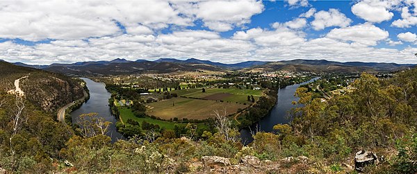
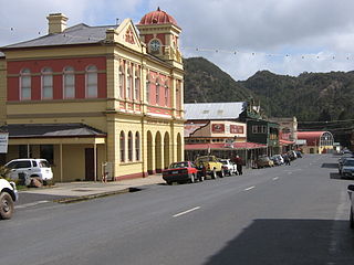
New Norfolk is a town on the Derwent River, in the south-east of Tasmania, Australia. At the 2011 census, New Norfolk had a population of 5,543. [1]

Tasmania island state of Australia

Tasmania is an island state of Australia. It is located 240 km (150 mi) to the south of the Australian mainland, separated by Bass Strait. The state encompasses the main island of Tasmania, the 26th-largest island in the world, and the surrounding 334 islands. The state has a population of around 526,700 as of March 2018. Just over forty percent of the population resides in the Greater Hobart precinct, which forms the metropolitan area of the state capital and largest city, Hobart.

Australia Country in Oceania

Australia, officially the Commonwealth of Australia, is a sovereign country comprising the mainland of the Australian continent, the island of Tasmania and numerous smaller islands. It is the largest country in Oceania and the world's sixth-largest country by total area. The neighbouring countries are Papua New Guinea, Indonesia and East Timor to the north; the Solomon Islands and Vanuatu to the north-east; and New Zealand to the south-east. The population of 25 million is highly urbanised and heavily concentrated on the eastern seaboard. Australia's capital is Canberra, and its largest city is Sydney. The country's other major metropolitan areas are Melbourne, Brisbane, Perth and Adelaide.

Contents

Situated 32 kilometres (20 mi) north-west of Hobart on the Lyell Highway, New Norfolk is a modern Australian regional centre which retains evidence of its pioneer heritage. Two examples of this heritage are Tasmania's oldest Anglican church, St. Matthews (built in 1823) and one of Australia's oldest hotels, The Bush Inn (Tasmania), trading continuously in the same building (built in 1815) since issue of the first licence on 29 September 1825. [2] Many private homes from the 1820s have also survived, such as Glen Derwent, Valleyfield, and Woodbridge.

Hobart City in Tasmania, Australia

Hobart is the capital and most populous city of the Australian island state of Tasmania. With a population of approximately 225,000, it is the least populated Australian state capital city, and second smallest if territories are taken into account. Founded in 1804 as a British penal colony, Hobart, formerly known as Hobart Town or Hobarton, is Australia's second oldest capital city after Sydney, New South Wales. Prior to British settlement, the Hobart area had been occupied for possibly as long as 35,000 years, by the semi-nomadic Mouheneener tribe, a sub-group of the Nuennone, or South-East tribe. The descendants of these Aboriginal Tasmanians often refer to themselves as 'Palawa'.

Lyell Highway highway in Western and Central Tasmania

The Lyell Highway is a highway in Tasmania, running from Hobart to Queenstown. It is the one of two transport routes that passes through the West Coast Range, the other being the Anthony Road (B28).

History

Before European Settlement

Before colonization by the British, the area now known as New Norfolk was occupied by the Leenowwenne clan, one of five clans of the Big River nation.

Resettlement of Norfolk Islanders

Replica oast houses built for a nursing home in New Norfolk OAST HOUSES, NEW NORFOLK, TASMANIA.jpg
Replica oast houses built for a nursing home in New Norfolk

Approximately 163 of the pioneers who settled around the town were from the 554 folk resettled when the first Norfolk Island settlement was closed, most arriving during the period between 29 November 1807 and 2 October 1808. [3] These Norfolk Islanders were mainly farming families, who were offered land grants in Tasmania as compensation for their relocation.

Norfolk Island external territory of Australia in the South Pacific Ocean, consisting of the island of the same name plus neighbouring islands

Norfolk Island is a small island in the Pacific Ocean located between Australia, New Zealand, and New Caledonia, 1,412 kilometres (877 mi) directly east of mainland Australia's Evans Head, and about 900 kilometres (560 mi) from Lord Howe Island. Together with the two neighbouring islands Phillip Island and Nepean Island it forms one of the Commonwealth of Australia's external territories. At the 2016 Australian census, it had 1748 inhabitants living on a total area of about 35 km2 (14 sq mi). Its capital is Kingston.

The climate was colder than sub-tropical Norfolk Island, which proved a challenge for the hardy pioneers during the first few years, but eventually the district became self-supporting. In 1825 the original name of the town, Elizabeth Town, was changed to New Norfolk in honour of their former home.

Many founding folk were "First Fleeters", transferred from Sydney to Norfolk Island when it was settled just a few weeks after Sydney. Ten First Fleeters are buried in the Methodist Chapel at Lawitta, New Norfolk.

Notable is Betty King, née Elizabeth Thackery, a first fleet convict girl who married at New Norfolk on the 28th January 1810. The headstone on Betty's well-tended grave reads, "The first white woman to set foot in Australia" from the First Fleet at Sydney Cove. She is also believed to be the last surviving First Fleeter, male or female, when she died at 89 years of age on 7 August 1856. Her husband was Marine Private Samuel King of the First Marine Regiment, another First Fleeter who arrived aboard the warship "Sirius". Sam King was the last male "First Fleeter" to survive until 21 October 1849, aged 86 years.

Elizabeth Thackery, died age 89 years, and is the last known survivor of the First Fleet, male or female, and was generally known throughout her long lifetime as the first convict female to land in Australia. Her husband Samuel King is thought to be the last male survivor of the "First Fleet".

Nine other First Fleeters were Ellen Guy (née Wainright), James Bryan Cullen, William Dempsey, William Edmunds, William Foyle, Abraham Hand, Stephen Martin, John Ruglass, and Edward Westlake.

The pioneers were successful farmers of the rich land around the town. Initially cattle and sheep were predominant, with some cropping as land was cleared. Hop plants were introduced in 1846, and became an important crop. A number of hop drying kilns or "oast houses" remain in the area including those at Glen Derwent (built by Cullen) and Valleyfield. [4]

Later history

The first road connecting the town to Hobart was built in 1818.

On 19 April 1827, Governor George Arthur issued an order to create the Willow Court infirmary, later known as Lachlan Park and most recently the Royal Derwent Hospital, as an asylum to accept sick and invalid convicts from Hobart, Launceston and outstations. Willow Court is now a large antiques centre.

The New Norfolk Post Office opened on 1 June 1832. [5]

For some years after 1848, New Norfolk was the place of exile of the Irish nationalist leader Terence MacManus. His cottage "Kilburn Grange" still stands. Later he was joined by his fellow Irish rebel, William Smith O'Brien, who lived at Elwin's Hotel (now known as Glen Derwent).

In 1887, the railway, now preserved as the Derwent Valley Railway, was built. In 1888, Australia's first telephone trunk call was connected from Hobart to the Bush Inn Hotel in New Norfolk. [4]

During the 1940s, a newsprint mill was established at nearby Boyer, boosting industry in the local area.

Transport

The Bridgewater Bridge was opened regularly by the Australian Newsprint Mills to transport paper via water to Hobart until 1984 when river transportation ceased. Bridgewater Bridge, Tasmania.jpg
The Bridgewater Bridge was opened regularly by the Australian Newsprint Mills to transport paper via water to Hobart until 1984 when river transportation ceased.

New Norfolk is located on the Lyell Highway the main east-west highway in the southern half of the state, running from Hobart to Strahan on the west coast. It is in fact the only east-west road in the southern half of Tasmania.

A rail link was opened in 1887 but was closed in 1995 when floods and declining usage made repairs uneconomic. The line has been used for tourist trips by the Derwent Valley Railway but this has not been possible since 2005 due to lack of support for track maintenance.

New Norfolk is 55 kilometres (34 mi) from Hobart International Airport.

Tourism

New Norfolk from Pulpit Rock Lockout New Norfolk from Pulpit Rock Lookout crop.jpg
New Norfolk from Pulpit Rock Lockout

New Norfolk is a central location for tourism in the upper Derwent Valley.

New Norfolk is near the tourist attractions of Mount Field, Lake Pedder, Strathgordon, Gordon Dam hydroelectric site, and the South West Wilderness. The Tourist Information Centre staffed by volunteers is located in Circle Street next to the Council Chambers at the top end of High Street.

In 2013 Martin Cash Pizza was voted best pizza maker in Tasmania.[ citation needed ]

Many of the historical farm house mansions, such as Glen Derwent and Tynwald, operate as bed and breakfast accommodation, tea rooms, restaurants and wedding venues.

The 1825 Heritage listed Woodbridge on the Derwent, on the river next to the bridge, operates as a small luxury hotel, and is presently one of more than 10 5-star hotels in Tasmania, although the building is located only 6 metres from a major highway carrying log trucks 24 hours a day. It draws a clientele from all over the world.

It has a long and interesting history. Built by hand by convicts for Captain Roadknight, the first Constable of the then Elizabeth Town, it was later owned by William Sharland, assistant surveyor of Tasmania, and his descendants. William Sharland constructed the wooden bridge across the Derwent next to Woodbridge - this was the first bridge across the Derwent, and the original Tollhouse still stands today.

By the 1950s, Woodbridge was derelict, and was converted into 7 flats. Again, by 2003, it was again derelict, and It was completely restored between 2003 and 2005. The restoration won the 2005 Tasmanian Restoration of the Year Award, and the 2006 Australian Restoration of the Year Award The building is unique in that it was built in the prevailing simple Georgian style, but it has an octagonal three storey central tower, reminiscent of French chateau.

Woodbridge, from the bridge over the Derwent Woodbridge on the Derwent, New norfolk.jpg
Woodbridge, from the bridge over the Derwent

Climate

New Norfolk is the warmest area of Tasmania in summer and has a cool temperate oceanic climate that is classified as Cfb under Köppen Climate Classification.

Climate data for New Norfolk, 1965-1983
MonthJanFebMarAprMayJunJulAugSepOctNovDecYear
Record high °C (°F)39.4
(102.9)
39.4
(102.9)
37.8
(100)
29.0
(84.2)
23.8
(74.8)
19.6
(67.3)
20.0
(68)
23.1
(73.6)
27.6
(81.7)
31.1
(88)
36.1
(97)
37.2
(99)
39.4
(102.9)
Average high °C (°F)25.2
(77.4)
25.0
(77)
22.2
(72)
18.3
(64.9)
14.2
(57.6)
11.0
(51.8)
9.9
(49.8)
10.9
(51.6)
14.5
(58.1)
17.6
(63.7)
19.3
(66.7)
22.7
(72.9)
17.3
(63.1)
Average low °C (°F)10.8
(51.4)
11.3
(52.3)
9.5
(49.1)
7.0
(44.6)
4.4
(39.9)
2.1
(35.8)
1.3
(34.3)
2.2
(36)
4.5
(40.1)
6.2
(43.2)
8.2
(46.8)
9.8
(49.6)
6.6
(43.9)
Record low °C (°F)−1.2
(29.8)
2.0
(35.6)
0.3
(32.5)
−1.0
(30.2)
−3.4
(25.9)
−5.7
(21.7)
−4.0
(24.8)
−2.8
(27)
−3.0
(26.6)
−1.5
(29.3)
0.0
(32)
1.2
(34.2)
−5.7
(21.7)
Average precipitation mm (inches)39.8
(1.567)
34.6
(1.362)
38.7
(1.524)
47.6
(1.874)
44.0
(1.732)
48.6
(1.913)
48.4
(1.906)
46.6
(1.835)
49.0
(1.929)
55.0
(2.165)
47.2
(1.858)
49.6
(1.953)
548.9
(21.61)
Average precipitation days8.06.88.810.111.112.013.013.913.213.812.010.8133.5
Source: [6]

See also

Related Research Articles

River Derwent (Tasmania) river in south east Tasmania, Australia

The Derwent River is a river located in Tasmania, Australia. It is also known by the palawa kani name timtumili minanya. The river rises in the state's Central Highlands at Lake St Clair, and descends more than 700 metres (2,300 ft) over a distance of more than 200 kilometres (120 mi), flowing through Hobart, the state's capital city, before emptying into Storm Bay and flowing into the Tasman Sea. The banks of the Derwent were once covered by forests and occupied by Tasmanian Aborigines. European settlers farmed the area and during the 20th century many dams were built on its tributaries for the generation of hydro-electricity.

Derwent derives from the Brythonic term Derventio, meaning "valley thick with oaks". It may refer to:

Queenstown, Tasmania Town in Tasmania, Australia

Queenstown is a town in the West Coast region of the island of Tasmania, Australia. It is in a valley on the western slopes of Mount Owen on the West Coast Range.

Glenorchy, Tasmania Suburb of Hobart, Tasmania, Australia

Glenorchy is a suburb of Hobart, in the state of Tasmania, Australia. Glenorchy is bound by the River Derwent to the east, Mount Wellington to the west, Hobart City to the south and Brighton to the north. The city officially begins at Creek Road Newtown, in Hobart's northern suburbs, and includes, Moonah, Derwent Park, Lutana, Goodwood, Chigwell, Claremont and Austins ferry. It is the seat of the local government area of the same name, the City of Glenorchy.

The history of Tasmania begins at the end of the most recent ice age when it is believed that the island was joined to the Australian mainland. Little is known of the human history of the island until the British colonisation in the 19th century.

Lake St Clair (Tasmania) lake in Tasmania, Australia

Lake St Clair or leeawulenna is a natural freshwater lake located in the Central Highlands area of Tasmania, Australia. The lake forms the southern end of the Cradle Mountain-Lake St Clair National Park. It has an area of approximately 45 square kilometres (17 sq mi), and a maximum depth of 160 metres (520 ft), making it Australia's deepest lake.

Sorell, Tasmania Town in Tasmania, Australia

Sorell is a town in Tasmania, Australia, north-east of Hobart. It is located on the Tasman Highway at the junction with the Arthur Highway. Sorell is one of Tasmania's oldest towns, being first settled in 1808 as a small farming community and becoming an official township in 1821. At the 2006 census, Sorell had a population of 1,546, and at the 2011 census, a population of 2,476. and at the 2016 census, a population of 2,907.

Zeehan Town in Tasmania, Australia

Zeehan is a town on the west coast of Tasmania, Australia 139 kilometres (86 mi) south-west of Burnie. It is located north of Strahan, Tasmania and Queenstown, Tasmania.

Bellerive, Tasmania Suburb of Hobart, Tasmania, Australia

Bellerive is a suburb of the City of Clarence, part of the greater Hobart area, Tasmania, Australia. It stretches from Kangaroo Bay where it borders Rosny Park, around the curved shoreline of Bellerive Esplanade to Kangaroo Bluff, then down to Bellerive Beach and east to Second Bluff, where Bellerive borders Howrah. To the north Bellerive is bordered by the small foothills of Waverly Flora Park.

Bridgewater Bridge (Tasmania)

The Bridgewater Bridge and Causeway spans the Derwent River in Tasmania, Australia between Bridgewater and Granton. It consists of a vertical lift bridge and a specially-built causeway connecting the bridge to the east bank of the river. It accommodates a two-lane highway, a single track railway and, on the bridge section, a footpath. As the bridge is the major connector of the Midland Highway on the eastern shore and the Brooker Highway on the western, the lifting of the bridge can cause considerable traffic delays, depending on the time of day and season.

Gormanston, Tasmania Town in Tasmania, Australia

Gormanston is a town in Tasmania on the slopes of Mount Owen, above the town of Queenstown in Tasmania's West Coast. At the 2006 census, Gormanston had a population of 167.

North Mount Lyell Railway

The North Mount Lyell Railway was built to operate between the North Mount Lyell mine in West Coast Tasmania and Pillinger in the Kelly Basin of Macquarie Harbour.

The modern history of the Australian city of Hobart in Tasmania dates to its foundation as a British colony in 1804. Prior to British settlement, the area had been occupied for at least 8,000 years, but possibly for as long as 35,000 years, by the semi-nomadic Mouheneener tribe, a sub-group of the Nuenonne, or South-East tribe. The descendants of the indigenous Tasmanians now refer to themselves as 'Palawa'.

Linda, Tasmania Town in Tasmania, Australia

Linda is the site of an old ghost town in the Linda Valley in the West Coast Range of Tasmania, Australia. It has also been known as Linda Valley.

Derwent Valley Railway (Tasmania)

The Derwent Valley Railway is a heritage railway in Tasmania, Australia. It operates from New Norfolk. It is 3' 6" narrow gauge.

Westerway, Tasmania Town in Tasmania, Australia

Westerway is a small town in southern Tasmania, Australia 68 kilometres (42 mi) west of Hobart on the Tyenna River. The Gordon River Road from New Norfolk to Strathgordon passes through it. It is in the Federal electorate Division of Lyons and is in the Derwent Valley Council local government area. At the 2006 census, Westerway and the surrounding area had a population of 156.

Westerway Railway Station is a railway station in the settlement of Westerway on the Derwent Valley Railway in Tasmania, Australia. The station was built in 1909 after the track was extended from Glenora.

References

  1. 1 2 Australian Bureau of Statistics (31 October 2012). "New Norfolk (Urban Centre/Locality)". 2011 Census QuickStats. Retrieved 4 December 2014. Blue pencil.svg
  2. "Bush Inn holds title of Australia's oldest pub" . Retrieved 2011-10-15.
  3. New Norfolk History 1986 ISBN   1-86252-303-7
  4. 1 2 "Derwent Valley". University of Tasmania. 2006. Retrieved 2009-12-05.
  5. Premier Postal History. "Post Office List". Premier Postal Auctions. Retrieved 16 June 2012.
  6. "Climate statistics for New Norfolk". Bureau of Meteorology. Retrieved 15 October 2011.

Further reading