Related Research Articles

Ganado is a chapter of the Navajo Nation and census-designated place (CDP) in Apache County, Arizona, United States. The population was 883 at the 2020 census, reduced from 1,210 at the 2010 census.

Window Rock, known in Navajo as Tségháhoodzání, is a city and census-designated place that serves as the capital of the Navajo Nation, the largest Native American tribe by both land and tribal enrollment. The capital lies within the boundaries of the St. Michaels Chapter, adjacent to the Arizona and New Mexico state line. Window Rock is the site of the Navajo Nation governmental campus, which contains the Navajo Nation Council, Navajo Nation Supreme Court, the offices of the Navajo Nation President and Vice President, and many Navajo government buildings.
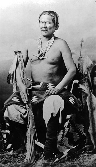
The Navajo are a Native American people of the Southwestern United States.
Hawkins Preserve is a 122-acre (0.49 km2) property within the city limits of Cortez, Colorado. It is protected by a conservation easement held by the Montezuma Land Conservancy.

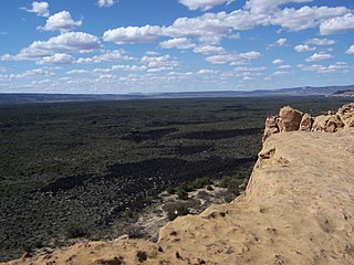
Canyons of the Ancients National Monument is a national monument protecting an archaeologically significant landscape located in the southwestern region of the U.S. state of Colorado. The monument's 176,056 acres (712.47 km2) are managed by the Bureau of Land Management, as directed in the presidential proclamation which created the site on June 9, 2000. Canyons of the Ancients National Monument is part of the National Landscape Conservation System, better known as the National Conservation Lands. This system comprises 32,000,000 acres (130,000 km2) managed by the Bureau of Land Management to conserve, protect, and restore these nationally significant landscapes recognized for their outstanding cultural, ecological, and scientific values. Canyons of the Ancients encompasses and surrounds three of the four separate sections of Hovenweep National Monument, which is administered by the National Park Service. The monument was proclaimed in order to preserve the largest concentration of archaeological sites in the United States, primarily Ancestral Puebloan ruins. As of 2022, over 8,500 individual archeological sites had been documented within the monument.

Dinétah is the traditional homeland of the Diné or Navajo, an Indigenous people of the Southwestern United States. In the Navajo language, the word "Dinétah" means "among the people" or "among the Navajo". In the geographical sense, Dinétah encompasses a large area of northwestern New Mexico, southwestern Colorado, southeastern Utah, and northeastern Arizona. The boundaries are inexact, and are generally marked by mountain peaks which correspond to the four cardinal directions.
The Christmas Tree Ruin is an archaeological site containing a Navajo pueblito, a defensive structure built in a high cliff wall approximately 200 feet above the floor of Gobernador Canyon in northwestern New Mexico, United States. The ruin, which is believed to have been built by the Navajo, dates to the 18th century, and was probably used for defensive, storage, and habitation purposes.

The Adolfo Canyon Site is an archaeological site containing a Navajo pueblito located in Rio Arriba County, New Mexico, United States. The site is situated on a rock outcrop overlooking Adolfo Canyon. The site consists of a three-room, single story pueblito, and extensive midden area, and six forked stick hogans on the crest of a ridge.
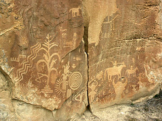
The Crow Canyon Archaeological District is located in the heart of the Dinétah region of the American Southwest in Rio Arriba and San Juan counties in New Mexico approximately 30 miles southeast of the city of Farmington. This region, known to be the ancestral homeland of the Navajo people, contains the most extensive collection of Navajo and Ancient Pueblo petroglyphs or rock art in the United States. Etched into rock panels on the lower southwest walls of the canyon are petroglyphs or rock art depicting what is believed to be ceremonial scenes and symbolic images that represent the stories, traditions and beliefs of the Navajo people. Dating back to the 16th, 17th, and 18th centuries, the petroglyphs have maintained their integrity despite the environmental conditions of the canyon and the effects of tourism. Among the ruins in the Crow Canyon Archaeological District there is also a cluster of Navajo defensive structures or pueblitos, which were built in the 18th century during periods of conflict with the Utes and the beginnings of Spanish Colonialism.

Fort Craig was a U.S. Army fort located along El Camino Real de Tierra Adentro, near Elephant Butte Lake State Park and the Rio Grande in Socorro County, New Mexico.

The term Navajo Pueblitos, also known as Dinétah Pueblitos, refers to a class of archaeological sites that are found in the northwestern corner of the American state of New Mexico. The sites generally consist of relatively small stone and timber structures which are believed to have been built by the Navajo people in the late 17th and early 18th centuries.
The Frances Canyon Ruin is a Navajo pueblito near Blanco in Rio Arriba County, New Mexico, United States. Built ca. 1716, it reflects economic and social changes taking place among the Navajo of this area during the 18th century. In the previous century the Spanish introduced sheep, fruit, cattle, and horses into the area. This, along with the Navajo's adaptation of certain pueblo lifeways after the Pueblo Revolt (1680-1692), led to increased settlement size and new trade relations. This site can be contrasted with modern Navajo communities which consist of clusters of hogans, widely dispersed with a trade system based on scattered trading posts and the motor vehicle.
The El Malpais National Conservation Area is a federally protected conservation area in the U.S. state of New Mexico. The El Malpais National Conservation area was established in 1987 and is managed by the Bureau of Land Management as part of the National Landscape Conservation System. The adjoining El Malpais National Monument was established at the same time and is managed by the National Park Service.

The Trail of the Ancients is a collection of National Scenic Byways located in the U.S. Four Corners states of Utah, Colorado, New Mexico, and Arizona. These byways comprise:

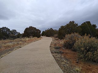
The Canyons of the Ancients Visitor Center and Museum located in Dolores, Colorado, is an archaeological museum of Native American pueblo and hunter-gatherer cultures. Two 12th-century archaeological sites, the Escalante and Dominguez Pueblos, at the center were once home to Ancient Pueblo peoples. The museum's permanent and special exhibits display some of the 3 million mostly Ancestral Puebloan artifacts curated at the facility. The center also houses a public research library, educational resources and a museum shop. Wheelchair-accessible facilities include a picnic area and an interpreted nature and cultural trail.

The Pueblo IV Period was the fourth period of ancient pueblo life in the American Southwest. At the end of prior Pueblo III Period, Ancestral Puebloans living in the Colorado and Utah regions abandoned their settlements and migrated south to the Pecos River and Rio Grande valleys. As a result, pueblos in those areas saw a significant increase in total population.
Sisyphus Shelter is an archaeological site that was uncovered in Colorado when the Colorado Department of Highways was working on I-70. The excavation of this site became a joint project between the Colorado Department of Highways and the Bureau of Land Management. Fieldwork on the site was completed in 1980. Archaeologists John Gooding and Wm. Lane Shields as well as many others completed the excavation and prepared a comprehensive site report. Over the course of the fieldwork on Sisyphus Shelter, twenty-six features of human origin were discovered as well as numerous stone artifacts and two perishable items. The artifacts appeared to be all Late Archaic in origin. Dating indicated a range of occupations from modern times to 4400 B.P. being the oldest sample. Gooding and Shields (1985) suggest that the occupations of the shelter were not consistent and affected by seasonal changes.
Wide Ruins is a chapter of the Navajo Nation and a census-designated place (CDP) in Apache County, Arizona, United States. The population was 176 at the 2010 census.

The Trail of the Ancients is a New Mexico Scenic Byway to prehistoric archaeological and geological sites of northwestern New Mexico. It provides insight into the lives of the Ancestral Puebloans and the Navajo, Ute, and Apache peoples. Geological features include canyons, volcanic rock features, and sandstone buttes. Several of the sites are scenic and wilderness areas with recreational opportunities.

The Ancestral Puebloans, also known as the Anasazi, were an ancient Native American culture that spanned the present-day Four Corners region of the United States, comprising southeastern Utah, northeastern Arizona, northwestern New Mexico, and southwestern Colorado. They are believed to have developed, at least in part, from the Oshara tradition, which developed from the Picosa culture. The people and their archaeological culture are often referred to as Anasazi, meaning "ancient enemies", as they were called by Navajo. Contemporary Puebloans object to the use of this term, with some viewing it as derogatory.
References
- Marshall, Michael P. and Hogan, Patrick, Rethinking Navajo Pueblitos New Mexico Bureau of Land Management, Cultural Resources Series No. 8, 1991. ISBN 1-878178-09-1
- Powers, Margaret A. and Johnson, Byron P., Defensive Sites of Dinetah New Mexico Bureau of Land Management, Cultural Resources Series No. 2, 1987. ISBN 1-878178-02-4