Chysauster Ancient Village is a late Iron Age and Romano-British village of courtyard houses in Cornwall, United Kingdom, which is currently in the care of English Heritage. The village included eight to ten houses, each with its own internal courtyard. To the south east is the remains of a fogou, an underground structure of uncertain function.

A fogou or fougou is an underground, dry-stone structure found on Iron Age or Romano-British-defended settlement sites in Cornwall. The original purpose of a fogou is uncertain today. Colloquially called vugs, vows, foggos, giant holts, or fuggy holes in various dialects, fogous have similarities with souterrains or earth-houses of northern Europe and particularly Scotland, including Orkney. Fewer than 15 confirmed fogous have been found.

Carn Euny is an archaeological site near Sancreed, on the Penwith peninsula in Cornwall, United Kingdom with considerable evidence of both Iron Age and post-Iron Age settlement. Excavations on this site have shown that there was activity at Carn Euny as early as the Neolithic period. There is evidence that shows that the first timber huts there were built about 200 BC, but by the 1st century BC, these had been replaced by stone huts. The remains of these stone huts are still visible today.

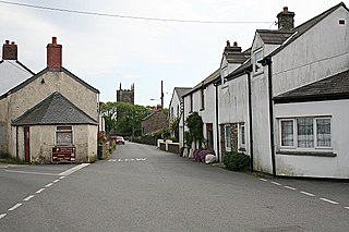
Pendeen is a village and ecclesiastical parish on the Penwith peninsula in Cornwall, United Kingdom. It is 3 miles north-northeast of St Just and 7 mi (11 km) west of Penzance. It lies along the B3306 road which connects St Ives to Land's End and the A30 road.

Boscaswell is a village in the extreme west of Cornwall, England, UK. It lies towards the cliffs looking west from Pendeen, within the St Just in Penwith division of Cornwall Council. It is a village consisting mostly of granite terraced cottages with a council house estate. Some of the cottages used to house tin mining families who would be working down the Geevor Tin Mine. The Atlantic Ocean is just beyond the cliffs. Higher Boscaswell is a hamlet south-east of Pendeen.
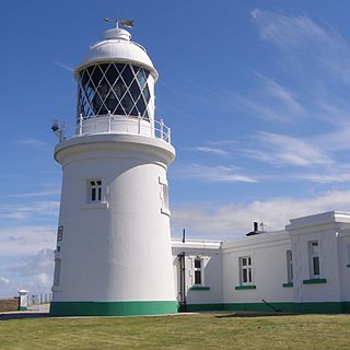
Pendeen Lighthouse, also known as Pendeen Watch is an active aid to navigation located 2 kilometres (1.2 mi) to the north of Pendeen in west Cornwall, England, United Kingdom. It is located within the Aire Point to Carrick Du SSSI, the Cornwall Area of Outstanding Natural Beauty and the Penwith Heritage Coast. The South West Coast Path passes to the south.
Carnyorth is a hamlet in west Cornwall, England, United Kingdom. It is approximately one mile (1.6 km) south of Pendeen and six miles (10 km) northwest of Penzance. It is in the civil parish of St Just in Penwith

Marhamchurch is a civil parish and village in north Cornwall, England, United Kingdom.

Manaccan is a civil parish and village on the Lizard peninsula in south Cornwall, England, United Kingdom. The village is about five miles (8 km) south-southwest of Falmouth.
St Newlyn East is a civil parish and village in Cornwall, England, United Kingdom. The village is approximately three miles (5 km) south of Newquay. The name St Newlyn East is locally abbreviated to Newlyn East and according to an anonymous historian writing in The Cornishman in 1880 it was only in recent years that Saint had been added to the parish name.

Sithney is a village and civil parish in West Cornwall, England, United Kingdom. Sithney is north of Porthleven. The population including Boscadjack and Crowntown at the 2011 census was 841.

Tehidy Country Park is a country park in Illogan in Cornwall, England which incorporates 250 acres (1.0 km2) of the parkland and estate around Tehidy House, a former manor house of the Tehidy manor. The park's facilities include an events field, barbecue hire facilities in a specially designated woodland, outdoor education facilities, a permanent orienteering course and a schools and youth campsite. The manor was a seat for many centuries of the junior branch of the Basset family which gained much wealth from local tin mining. The estate and house were purchased by Cornwall County Council in 1983 and the country park is one of four in Cornwall.
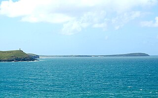
Trevose Head is a headland on the Atlantic coast of north Cornwall, United Kingdom. It is situated approximately 5 miles (8.0 km) west of Padstow. The South West Coast Path runs around the whole promontory and is within the Cornwall Area of Outstanding Natural Beauty and the Trevose Head Heritage Coast. In clear weather, visitors to Trevose Head can see virtually the whole length of the north Cornwall coast; to the north, the view extends beyond the Cornwall county boundary to Hartland Point, Devon; to the south, it extends beyond St Ives to the headland at Pendeen Watch.

Bodrean and Frogmore are farmstead settlements in Cornwall, England, United Kingdom, situated two miles north-northeast of Truro.
Caer Bran Hill Fort is an archaeological site near Sancreed and Carn Euny Iron Age village, on the Penwith peninsula in Cornwall.

Lower Boscaswell is a hamlet near Pendeen in Cornwall, England.

Botallack is a village in west Cornwall, England, United Kingdom. It lies along the B3306 road which connects St Ives in the east to the A30 road, near Land's End. The village is included in the St Just in Penwith division on Cornwall Council. The original 1970s BBC television series Poldark was filmed partly in Botallack, using Manor Farm as Nampara. The Manor House, part of the Tregothnan estate, is a Grade II* listed building, dating from the 17th century.

The B3306, also known as the West Cornwall Coast Road, is a major road of southwestern Cornwall. It connects St Ives in the east to St Just in the west, and eventually joins the A30 road to the northeast of Sennen in the southwest of the Penwith peninsula. This thirteen-mile road is often voted one of the greatest driving roads in the United Kingdom for its scenery, with most of the road having views both across the Celtic Sea to the north, and the Cornish moorland to the south. It hugs the coastline for a great proportion of its length.
Treveneague is an area near Goldsithney, Penzance, in the civil parish of St Hilary. It was originally composed of two places, North Treveneague and South Treveneague. The Grade II listed early 19th century North Treveneague Farmhouse and Farm Buildings North of Treveneague Farmhouse are located here. In the 1860s, an Iron Age fogou was discovered at Treveneague.

Botallack Manor was built in the 17th century. The house featured in the BBC television series Poldark, and is a Grade II* listed building situated in St Just, Cornwall.