Pollution of the Ganges

Last updated

Funeral ghats in Varanasi Funeral on the Ghats.jpg
Funeral ghats in Varanasi

The ongoing pollution of the Ganges , the largest river in the Indian subcontinent, poses a significant threat to human health and the environment. [1] The river provides water to about 40% of India's population across 11 states. [2] It serves an estimated population of 500 million people, more than any other river in the world. [3] [4]

Contents

It is severely polluted with human waste and industrial contaminants. Today, the Ganges is considered to be the fifth-most polluted river in the world. [5] Stretches of over 600 km (370 mi) are considered ecologically dead zones. [6]

An Indian photographer has noted that no one in India spoke of the Ganges as being polluted until the late 1970s. [7] However, pollution affected the river before wider attention was brought to the topic.

A number of initiatives were undertaken to clean the river, but they failed to deliver significant results. [8] After getting elected, India's Prime Minister Narendra Modi pledged to work on cleaning the river and controlling pollution. [9] Subsequently, in the June 2014 budget, the government announced the Namami Ganga project. [10] By 2016, an estimated Rs 30 billion (US$460 million) had been spent in various efforts to clean up the river, to little avail. [11]

Causes

The main causes of water pollution in the Ganges River, like many other rivers, are the disposal of human sewage and animal waste, increasing population density, and the disposal of industrial waste into the river. [12]

Human waste

The river flows through 100 cities with populations over 100,000 residents, 97 cities with populations between 50,000 and 100,000 residents, and about 48 towns. [13] A large proportion of the sewage with higher organic load in the Ganges comes from this population through domestic water usage.

Industrial waste

There are a large number of industrial cities on the bank of the Ganges, like Kanpur, Prayagraj, Varanasi and Patna, as well as tanneries, chemical plants, textile mills, distilleries, slaughterhouses, and hospitals. These cities and facilities along the Ganges actively play a role in polluting the river by dumping untreated waste into it. [14] One coal-based power plant on the banks of the Pandu River, a Ganges tributary, burns 600,000 tons of coal each year and produces 210,000 tons of fly ash. The ash is dumped into ponds, from which a slurry is filtered, mixed with domestic wastewater, and then released into the Pandu River. Fly ash contains toxic heavy metals such as lead and copper. The amount of parts per million of copper released in the Pandu before it even reaches the Ganges is a thousand times higher than in uncontaminated water. [2] Industrial effluents account for about 12% of the total volume of effluent reaching the Ganges. Although a relatively low proportion, they are a cause for major concern because they are often toxic and non-biodegradable. [2] Plastic and industrial waste, such as wastewater from factories that sit on the banks of the Ganges, are another cause of pollution. The most worrying problem facing the river is its increasing lack of water, which is being used for irrigation faster than it can be replenished.

Religious traditions

During festival seasons, over 70 million people bathe in the Ganges to cleanse themselves of their past sins. [15] Some materials, such as food, waste, or leaves, are left in the Ganges, which is also responsible for its pollution. Traditional beliefs hold that being cremated on its banks and floating down the Ganges will cleanse the sins of those who die and carry them directly to salvation. In Varanasi alone, an estimated forty thousand bodies are cremated every year and deposited into the Ganges. Because many families cannot afford the high cost of sufficient quantities of cremation wood, many of the bodies deposited into the Ganges are only half-burnt. [6]

Dams and pumping stations

Built in 1854 during the British colonization of India, the Haridwar dam has led to the decay of the Ganges by greatly diminishing the flow of the river. [16] The Farakka Barrage was built originally to divert fresh water into the Hooghly River but has since caused an increase in salinity in the Ganges, having a damaging effect on the groundwater and soil along the river. [13] The barrage has caused major tension between Bangladesh and India. Bangladesh was actively considering construction of the Ganges Barrage Project to mitigate the salinity problem. [17] The Indian government has planned about 300 dams on the Ganges and its tributaries in the near future, despite a government-commissioned green panel report that has recommended scrapping 34 of the dams, citing environmental concerns. [18]

Three more dams across the Ganges main river exist at Bijnor, Narora and Kanpur. [19] The dams at Bijnor and Narora divert all the water, including baseflows during the dry season, to the canals for irrigating areas up to Allahabad city. Flow upstream of the Kanpur barrage is used during dry season for the drinking water of cities. [20] Downstream of Kanpur dam, adequate water volumes are unavailable during the dry seasons of year. [21]

There are a number of pumping stations located on the banks of the Ganges downstream of the Kanpur barrage, serving the irrigation requirements of the region. [22] These large pump houses are located at Rukunpur 26°10′21″N80°38′57″E / 26.17250°N 80.64917°E / 26.17250; 80.64917 , Kanjauli Kachhar 25°17′37″N82°13′15″E / 25.29361°N 82.22083°E / 25.29361; 82.22083 , Hakanipur Kalan 25°12′57″N83°01′15″E / 25.21583°N 83.02083°E / 25.21583; 83.02083 , Bhosawali 25°20′46″N83°10′11″E / 25.34611°N 83.16972°E / 25.34611; 83.16972 , Shekpur 25°32′13″N83°11′57″E / 25.53694°N 83.19917°E / 25.53694; 83.19917 , Chochakpur 25°28′55″N83°25′11″E / 25.48194°N 83.41972°E / 25.48194; 83.41972 , Lamui 25°23′20″N83°32′11″E / 25.38889°N 83.53639°E / 25.38889; 83.53639 , Chausa 25°31′11″N83°54′04″E / 25.51972°N 83.90111°E / 25.51972; 83.90111 . The irrigation facilities pump out most of the base flows in the main river downstream of Kanpur city.

To keep the Ganges flowing and dilute polluted water inflows from habitations and industries, at least 5,000 cusecs flow are required from Narora to Farakka at a minimum environmental flow during the eight-month-long dry season. [23] This could be done by constructing storage reservoirs of capacity 100 Tmcft across the Ganges tributaries located upstream of Narora city and reserving the stored water only for minimum environmental flows. [24] In addition, a series of cascading dam bridges are to be constructed across the river from Kanpur to Allahabad to increase the surface area of impounded polluted water in the river and serve as natural oxidation ponds. The intended effect is to have the accumulated pollutants wash away during the annual monsoon floods. Already, a number of dams are planned between Farakka and Allahabad to make the 1,620 km length of the river navigable from Haldia to Allahabad under the National Waterway 1 project, which can be extended up the Kanpur. [25]

Statistics

A 2006 measurement of pollution in the Ganges revealed that river water monitoring over the previous 12 years had demonstrated fecal coliform counts up to 100,000,000 MPN per 100 mL [26] and biological oxygen demand levels averaging over 40 mg/L in the most polluted part of the river at Varanasi. The overall rate of water-borne disease incidence, including acute gastrointestinal disease, was estimated to be about 66%. [27]

A systematic classification done by Uttarakhand Environment Protection and Pollution Control Board's (UEPPCB) on river waters into the categories A: safe for drinking, B: safe for bathing, C: safe for agriculture, and D: excessive pollution, put the Ganges in category D. Coliform bacteria levels in the Ganges have also been tested to be at 5,500, a level too high to be safe for agricultural use let alone drinking and bathing. [28]

The leather industry in Kanpur which employs around 50,000 people in more than 400 tanneries using chemicals such as toxic chromium compounds. Effectively, chromium levels have not decreased in the Ganges even after a common treatment plant was established in 1995. It now stands at more than 70 times the recommended maximum level. [29]

A study conducted by the National Cancer Registry Program (NCRP) under the Indian Council of Medical Research in 2012, suggested that "those living along its banks in Uttar Pradesh, Bihar and Bengal are more prone to cancer than anywhere else in the country". [30]

In 2020, a study showed that the level of toxic heavy metals has significantly improved in recent years. This study was supported by Indo-US Science and Technology Forum (IUSSTF). [31]

Effects

Marine life

The results of mercury analysis in various specimens collected along the basin indicated that some fish muscles tended to accumulate high levels of mercury. Of it, approximately 50-84% was organic mercury. A strong positive correlation between mercury levels in muscle with food habit and fish length was found. [32]

The Ganges river dolphin is one of few species of fresh water dolphins in the world. Listed as an endangered species, their population is believed to be less than 2,000. Hydroelectric and irrigation dams along the Ganges that prevents the dolphins from traveling up and down river is believed to be the main reason for their declining population. [33] The Ganges softshell turtle (Nilssonia gangetica) is found in the Ganges, Indus, and Mahanadi river systems of Pakistan, India, Bangladesh, and Nepal. This turtle inhabits deep rivers, streams, large canals, lakes, and ponds with beds of mud or sand. According to the International Union for Conservation of Nature, the turtle species is vulnerable. [1] Due to their long lifespan and high trophic level in the aquatic food web, turtles are vulnerable to heavy metal pollution, a major type of pollution in the Ganges. [34]

Wildlife

Some of the dams being constructed along the Ganges basin will submerge substantial areas of nearby forest. For example, the Kotli-Bhel dam at Devprayag will submerge 1,200 hectares of forest, wiping out the forest ecosystem and the wildlife. [2]

Humans

An analysis of the Ganges water in 2006 and 2007 showed significant associations between water-borne disease and the use of the river for bathing, laundry, washing, eating, cleaning utensils, and brushing teeth. [27] Water in the Ganges has been correlated to contracting dysentery, cholera, hepatitis, [14] as well as severe diarrhea which continues to be one of the leading causes of death of children in India. [35]

During the summer and monsoon, hospital wards teem with children who need treatment for waterborne diseases - but according to S.C. Singh, a paediatrician at Varanasi Shiv Prasad Gupta Hospital, their parents rarely mention that they have been swimming in the river. They don't appear to have made the connection, he says. [36]

Cleanup efforts

Ganga Mahasabha

Ganga Mahasabha is an Indian organization dedicated to the Ganges, founded by Madan Mohan Malaviya in 1905. After a long struggle British India agreed on 5 November 1914 to the Ganga Mahasbha, stating the uninterrupted flow of the Ganges is the rudimentary right of Hindus. The day is known as a "Aviral Ganga Samjhauta Divas" (Uninterrupted Ganga Flow Agreement Day) in the history of India. The agreement came into existence on 19 December 1916, known as Agreement of 1916. The sanctity of the agreement is not preserved by the state and central governments of India after independence, though it is legally valid. More and more river water is diverted for irrigation use, exacerbating the pollution and strain.

Ganga Action Plan

Ganges canal dried for cleaning The Ganga Canal Dried for Cleaning the River Bed.png
Ganges canal dried for cleaning

The Ganga Action Plan (GAP) was launched by Rajiv Gandhi, then Prime Minister of India, in June 1985 [37] with covering 25 Class I towns (6 in Uttar Pradesh, 4 in Bihar and 15 in West Bengal); [38] 862.59 crore were spent. Its main objective was to improve the water quality by the interception, diversion, and treatment of domestic sewage and to prevent toxic and industrial chemical wastes from identified polluting units from entering the river. The other objectives of the GAP are as follows: [39]

Notwithstanding some delay in the completion of the first phase of the GAP, it has generated considerable interest and set the scene for evolving a national approach towards replicating this program for the other polluted rivers of the country. The Government of India proposed to extend this model with suitable modifications to the national level through a National River Action Plan (NRAP). The NRAP mainly draws upon the lessons learned and the experience gained from the GAP besides seeking the views of the State Governments and the other concerned Departments and Agencies. Under the NRCP scheme, the CPCB had conducted river basin studies and had identified 19 polluted stretches and 14 less polluted stretches along 19 rivers, which include 11 stretches situated along 7 rivers of M.P.

Phase II covered 59 towns in five states, in which more than Rs 5.053 billion were spent. Rivers such as Yamuna, Gomti, Damodar, Mahananda had separate action plans. [39]

National Ganga River Basin Authority (NGRBA)

NGRBA was established by the Central Government of India, on 20 February 2009 under Section 3 of the Environment Protection Act, 1986. It declared the Ganges as the "National River" of India. [40] The chair includes the Prime Minister of India and chief ministers of states through which the Ganges flows. [41] In 2011, the World Bank approved $1 billion in funding for the National Ganges River Basin Authority. [42]

2010 Government clean-up campaign

In 2010, it was announced that "the Indian government has embarked on a US$4 billion campaign to ensure that by 2020 no untreated municipal sewage or industrial runoff enters the 1,560-mile river." [43] A World Bank spokesman described the plan in 2011, saying:

Earlier efforts to clean the Ganges concentrated on a few highly polluting towns and centres and addressed 'end-of-the-pipe' wastewater treatment there; Mission Clean Ganga builds on lessons from the past, and will look at the entire Gangetic basin while planning and prioritising investment instead of the earlier town-centric approach. [42]

Lobby group Sankat Mochan Foundation (SMF) "is working with GO2 Water Inc., a Berkeley, California, wastewater-technology company" to design a new Sewage treatment system for Varanasi. [43]

The Supreme Court of India has been working on the closure and relocation of many of the industrial plants such as Tulsi along the Ganges. In 2010 the government declared the stretch of river between Gaumukh and Uttarkashi an Eco-sensitive zone. [28]

Namami Gange Programme

In the budget drafted in Parliament on 10 July 2014, the Union Finance Minister Arun Jaitley announced an integrated Ganges development project titled "Namami Gange" (meaning 'Obeisance to the Ganges river') and allocated 2,037 crore for this purpose. [10] The objectives were effective abatement of pollution, conservation, and rejuvenation of the Ganges. Under the project, 8 states are covered. Ministry of Drinking Water Supply and Sanitation proposed to make 1,674 gram panchayats by the Ganges open defecation-free, at a cost of 1,700 cr (central share). An estimated 2,958 Crores (US$460 million) had been spent until July 2016 in various efforts in cleaning up of the river.

As a part of the program, government of India ordered the shut down of 48 industrial units around the Ganges. [44]

The program had a budget outlay of 20,000 crore for the next five years. This is a significant five-fold increase over the expenditure in the past 30 years (Government of India incurred an overall expenditure of approximately 4,000 crore on this task since 1985). The centre will now take over 100% funding of various projects under this program. Taking note from the unsatisfactory results of the earlier Ganges Action Plans, the centre now plans to provide operation and maintenance assets for a minimum 10-year period, and adopt a PPP/SPV approach for pollution hotspots.

In an attempt to bolster enforcement, the centre also plans to establish a four-battalion Ganges Eco-Task Force. The program emphasises on improved coordination mechanisms between various ministries or agencies of central and state governments. Major infrastructure investments which fall under the original mandate of other ministries. In addition, Urban Development (UD), Drinking Water & Sanitation (DWS), Environment Forests & Climate Change (EF&CC) etc., will also be undertaken.

"Namami Gange" will focus on pollution abatement interventions, primarily interception, diversion, and treatment of waste water flowing through open drains through bio-remediation, appropriate in-situ treatment, use of innovative technologies, sewage treatment plants (STPs), and effluent treatment plant (ETPs) for rehabilitation and augmentation of existing STPs and immediate short term measures for preventing pollution at exit points to river, preventing inflow of sewage etc.

Significantly, the approach is notable for socio-economic benefits the program is expected to deliver for job creation, improved quality-of-life, and health benefits to the vast population that is dependent on the river. [45]

The main pillars of Namami Gange Programme are:

  1. Sewerage Treatment Infrastructure
  2. River-Front Development
  3. River-Surface Cleaning
  4. Bio-Diversity
  5. Afforestation
  6. Public Awareness
  7. Industrial Effluent Monitoring
  8. Ganga Gram

Namami Gange Mission-II

With the success of the Namami Gange Programme, the government of India allocated 22,500 crore for Namami Gange Mission-II which intends to provide more maintenance of the Ganges (funds allocated until 2026). [46] From FY 2014–15 through 31 January 2023, the government provided the National Mission for Clean Ganga (NMCG) a total of ₹14,084.72 crore. Of that amount, the NMCG has given out ₹13,607.18 crore to state governments, state missions for cleaning the Ganges, and other organizations for the implementation of projects related to rejuvenation of the Ganges. [47] [48]

Ganga Manthan

Ganga Manthan was a national conference held to discuss issues and possible solutions for cleaning the river. [49] [50]

The conference aimed to take feedback from stakeholders and prepare a road map for rejuvenating the Ganges. The event was organised by the National Mission for Clean Ganga (NMCG) on 7 July 2014 at Vigyan Bhawan in New Delhi. [51] [52]

Nepal to release water during lean flow period

Nepal has constructed many barrages (excluding joint projects with India) or pump houses to divert the lean season river flows for irrigation purpose. [53] These water diversion projects are located near 28°25′29″N81°22′49″E / 28.42472°N 81.38028°E / 28.42472; 81.38028 , 28°02′24″N81°57′12″E / 28.04000°N 81.95333°E / 28.04000; 81.95333 , 27°52′51″N82°30′13″E / 27.88083°N 82.50361°E / 27.88083; 82.50361 , 27°40′00″N83°06′49″E / 27.66667°N 83.11361°E / 27.66667; 83.11361 , 27°42′17″N84°25′57″E / 27.70472°N 84.43250°E / 27.70472; 84.43250 , 27°08′11″N85°29′01″E / 27.13639°N 85.48361°E / 27.13639; 85.48361 , 26°53′09″N86°08′13″E / 26.88583°N 86.13694°E / 26.88583; 86.13694 , 26°50′13″N87°09′01″E / 26.83694°N 87.15028°E / 26.83694; 87.15028 , 26°41′05″N87°52′43″E / 26.68472°N 87.87861°E / 26.68472; 87.87861 , etc. India being lower riparian state has right to claim share out of the river water flows from Nepal similar to India entered into river water sharing agreement with Bangladesh recognising it as lower riparian state. [54] Till now there is no bilateral agreement between India and Nepal adhering to equitable sharing of river waters during the lean season. When Nepal releases water into India during the lean flow period, it would help in cleaning / diluting the polluted waters of downstream Ganges river up to Farakka barrage.

Water diversion from Manasarovar lake

A satellite view of the Manasarovar (right) and Rakshastal lakes with Mount Kailash in the background Mt Kailash sat.jpg
A satellite view of the Manasarovar (right) and Rakshastal lakes with Mount Kailash in the background

For restoring the minimum environmental flows, it is difficult to identify nearly 100 Tmcft storage reservoirs in the hilly region of Ganges basin in India as the river is flowing through steep valleys. Already big storage reservoirs like Tehri and Ramganga are constructed at feasible locations. However the water of Manasarovar Lake can be diverted to Mabja Zangbo river, a tributary of Karnali river in China, to reach upstream of Kanpur barrage (117 m msl) via Girijapur Barrage (129 m msl) located at 28°16′21″N81°05′09″E / 28.27250°N 81.08583°E / 28.27250; 81.08583 across the Ghaghara/Karnali river which is a tributary of Ganges river flowing from Tibet and Nepal. [55]

Manasarovar Lake's surface area is 320 square kilometres (120 sq mi), and its maximum depth is 90 m (300 ft). It holds more than 100 tmcft water in its top 13 metres depth. At present it is overflowing into nearby Lake Rakshastal which is a landlocked saltwater endorheic lake. The annual water inflows from the catchment area of Manasarovar lake located at 4,590 metres (15,060 ft) above msl, can be diverted by gravity to the Karnali River basin of China through a 15-kilometre long tunnel. [55]

The diverted water available continuously can be used in China for hydroelectric power generation where the head drop available is in excess of 800 metres over a 40 km long stretch. This would be a joint project of China, Nepal and India for controlling river water pollution and making the Ganges river live and flowing throughout the year. With the diversion of Manasarovar lake water to Ganges basin, Lake Rakshastal would turn into a soda lake with further increase in water salinity which is useful in abstracting the water-soluble chemicals on a commercial scale. [55]

The fresh water inflows into Manasarovar lake can be augmented further substantially by gravity diversion of the inflows available from the major catchment area of Rakshastal lake to Manasarovar lake by constructing an earth dam isolating northern tip of Rakshastal lake where it is fed by its substantial catchment area and also connected to the Manasarovar lake. [55]

Utilisation of Ganges and Brahmaputra flood waters to fight pollution in all rivers of India

A freshwater coastal reservoir with massive storage capacity can be established on the shallow sea area adjoining West Bengal, Odisha and Bangladesh coast by constructing sea dikes / bunds/ causeway up to the depth of 20 meters. [56] [57] [58] [59] Water can be pumped from this artificial freshwater lagoon throughout the year with abundant hydro, wind, and solar power resources of India to many river basins in India for meeting needs of agriculture, maintaining base and environmental flows, salt export requirements, ultimate energy storage needs of India and Bangladesh by creating pumped storage hydroelectric potential, carbon sequestration into topsoil to mitigate climate change, etc. [60] Nearly 360 billion cubic meters (bcm) storage capacity fresh water coastal reservoir/lagoon can be located on the sea area which stretches from the coast of south eastern Bangladesh (near 29°21′43″N91°52′09″E / 29.36194°N 91.86917°E / 29.36194; 91.86917 ) to the mouth of Brahmani River (near 20°49′37″N86°57′57″E / 20.82694°N 86.96583°E / 20.82694; 86.96583 ). [60] The dike would be envisaged with gated barrages to pass to the sea the excess flood waters received from the Ganges, Brahmaputra, Meghana, etc. rivers for limiting the maximum reservoir level (FRL) to nearly 2.0 m above MSL (below local high tide level). [61]

From this coastal reservoir, water is pumped to a stream of embankment canals to basins of Damodar River, Subarnarekha River, Sone, right side of Narmada, Ganges, Kosi, Gandak, Yamuna, Chambal, Sabarmati, Dhadhar, Mahi, Ghaggar, Sutlej and coastal rivers of Gujarat. Another stream of embankment canals originating from the coastal reservoir pump water to the basins of Brahmani River, Biatarni River, Mahanadi, Godavari, left side of Narmada, Tapi, and Krishna. [60] Adequate water would be made available for all needs from the coastal reservoir to Jharkhand, Odisha, Chhattisgarh, West Bengal, Uttar Pradesh, Bihar, Maharashtra, Madhya Pradesh, Chhattisgarh, Rajasthan, Gujarat, Haryana, Karnataka, Telengana, and Delhi states.

The advantage of this scheme is that Ganges and Bramhaputra river waters can be stored on Bay of Bengal sea area and nearly 1200 bcm of water is transferred throughout the year to other river basins including the Ganges basin at the optimum pumping head. [60] [62]

A map of the Ganges (orange), Brahmaputra (violet), and Meghna (green) drainage basins Ganges-Brahmaputra-Meghna basins.jpg
A map of the Ganges (orange), Brahmaputra (violet), and Meghna (green) drainage basins

Nearly 1000 million tons (500 million cubic meters) of sediment annually from Ganges and Brahmaputra rivers is settling in the sea coast of Bangladesh and India, and the sea area is shallow (up to 20 m depth) for 60 km wide on average. Bangladesh plagued with high population density, can reclaim nearly 7,500 km2 (5% of its total land) area of sea by excavating/dredging sediment from the freshwater lagoon bed without any effect on the water storage of the coastal reservoir. [63]

The presence of the protective sea dike makes sub-sea soil dredging easier and more economical through protection from rough sea waves. This reclaimed area from the sea can be utilized for locating a megacity to cater to the modern needs of Bangladesh. This coastal dike would protect Bangladesh from wave and tidal activity during the frequent cyclones preventing human and property losses drastically and also from sea level rise due to global warming. Thus Bangladesh would also benefit immensely from this coastal reservoir project.

The sea dike's top level at 12 m above the mean sea level and 50 m wide at the top surface, would be nearly 600 km long connecting the Indian mainland to Southeast Bangladesh forming a transnational highway and rail route from the Indian subcontinent to East Asia up to Singapore and China. Also, this dike can be used as an accessway connecting deep sea ports located close to this dike. The proposed dike would be similar to the land reclamation of North Sea area called Delta Works in Netherlands. The experience of the Saemangeum Seawall already constructed in South Korea which is 33 km long and with 36 meters average depth, can be utilized for this project which is a lesser challenging project. Locks arrangement (similar to Panama canal) would be provided for the movement of ships from the open sea to harbors located in Bangladesh and India.

The offshore earth dam extending up to 12 m above the msl height, is in the form of two parallel dikes separated by 1000 meters gap. The main purpose of the twin dikes is to prevent any sea water seepage into the coastal reservoir as its water level is below the sea level. The water level between the dikes is always maintained minimum of 2 meters above the sea level by pumping fresh water from the coastal reservoir into the 1000 m gap between the dikes. The higher level water barrier between the two dikes fully eliminates any seawater seepage into the coastal reservoir by establishing freshwater seepage to the sea. [60] The 600 km long, 1000 m gap between the two dikes is also used as deep water mega harbor for shipping, ship breaking, ship building, etc. For shipping purposes, the breakwater outer dike facing the sea is envisaged with a few locks fitted with twin gates for access to the open sea. The top surface of the inner dike would serve as access to the mainland from the mega harbor with rail and road links. The coastal reservoir whose full reservoir water level (FRL) is at 0.0 m msl, would also reduce drastically the cyclone damage and flooding in adjacent coastal areas.[ citation needed ]

The cost of the total project including coastal reservoir, contour canals, water pumping stations, solar/wind/hydro power plants, canal drop hydropower stations, main canals, tunnels, aqueducts, barrages, and distribution canals is estimated nearly ₹ 125 trillion (lakh crores INR) at year 2021 prices. [60] [64] The irrigation potential of the project alone is 300 million acres with water supply throughout the year. It is a gigantic multi-purpose project where cleaning of many major rivers of India by providing adequate base flows and minimum environmental flows (not Ganges river alone) from the water pollution is one of its purposes. [65]

Clean Ganga Fund

The Union Cabinet gave its approval for setting up of Clean Ganga Fund in September 2014 with the aim of using the collection for various activities under the Namami Gange programme for cleaning the Ganges.

Utilisation of funds: [66]

National Mission for Clean Ganga

Pollution in Ganga Pollution of Ganga.jpg
Pollution in Ganga

The National Mission for Clean Ganga (NMCG) is the implementation wing of National Ganga Council which was set up in October 2016 under the River Ganga (Rejuvenation, Protection and Management) Authorities order 2016. The order dissolved National Ganga River Basin Authority. The aim is to clean the Ganges and its tributaries in a comprehensive manner. [68] Gajendra Singh Shekhawat is the present Union Cabinet Minister in Ministry of Jal Shakti. [69]

Namami Gange Programme

Under National Mission for Clean Ganga, Namami Gange Programme was launched in 2014. This is a Flagship program under Union Government. A budget of 20,000 crore was given with the twin objective of effective abatement of pollution, conservation and rejuvenation of National River Ganga. [70] Unlike previous projects for cleaning Ganga, Namami Gange is most comprehensive river conservation program. [71]

Protests for cleaning the Ganges

Nigamanand

In early 2011, a Hindu monk named Swami Nigamananda Saraswati fasted to death, protesting against pollutive river bed quarrying of the Ganges happening in the district of Haridwar, Uttarakhand. [72] Following his death in June 2011, his ashram leader Swami Shivananda fasted for 11 days starting on 25 November 2011, taking his movement forward. On 5 December 2011, the Government of Uttarakhand released an order to ban river bed mining in the Bhogpur and Bishanpur ghats. [73] According to administration officials, quarrying in the Ganges would now be studied by a special committee which would assess its environmental impacts on the river and its nearby areas.

G. D. Agrawal

G. D. Agrawal was an environment activist and patron of Ganga Mahasabha, an organisation founded by Madan Mohan Malviya in 1905, demanding removal of dams on Ganges. [74] Because of support from other social activists like Anna Hazare, the then-Prime Minister of India, Manmohan Singh agreed to Agrawal's demands. Accordingly, he called for a National River Ganga Basin Authority (NRGBA) meeting and urged the authorities to utilise the 26 billion (US$520M) sanctioned "for creating sewer networks, sewage treatment plants, sewage pumping stations, electric crematoria, community toilets and development of river fronts". [2] Agrawal died on 11 October 2018, after being on an indefinite fast since 22 June 2018, demanding the government act on its promises to clean and save the Ganges. [75]

See also

Related Research Articles

<span class="mw-page-title-main">Ganges</span> Major river in Asia

The Ganges River is a trans-boundary river of Asia which flows through India and Bangladesh. The 2,525 km (1,569 mi) river rises in the western Himalayas in the Indian state of Uttarakhand. It flows south and east through the Gangetic plain of North India, receiving the right-bank tributary, the Yamuna, which also rises in the western Indian Himalayas, and several left-bank tributaries from Nepal that account for the bulk of its flow. In West Bengal state, India, a feeder canal taking off from its right bank diverts 50% of its flow southwards, artificially connecting it to the Hooghly River. The Ganges continues into Bangladesh, its name changing to the Padma. It is then joined by the Jamuna, the lower stream of the Brahmaputra, and eventually the Meghna, forming the major estuary of the Ganges Delta, and emptying into the Bay of Bengal. The Ganges–Brahmaputra–Meghna system is the second-largest river on earth by discharge.

<span class="mw-page-title-main">Godavari River</span> River in south-central India

The Godavari is India's second longest river after the Ganga river and drains the third largest basin in India, covering about 10% of India's total geographical area. Its source is in Trimbakeshwar, Nashik, Maharashtra. It flows east for 1,465 kilometres (910 mi), draining the states of Maharashtra (48.6%), Telangana (18.8%), Andhra Pradesh (4.5%), Chhattisgarh (10.9%) and Odisha (5.7%). The river ultimately empties into the Bay of Bengal through an extensive network of distributaries. Measuring up to 312,812 km2 (120,777 sq mi), it forms one of the largest river basins in the Indian subcontinent, with only the Ganga and Indus rivers having a larger drainage basin. In terms of length, catchment area and discharge, the Godavari is the largest in peninsular India, and had been dubbed as the Dakshina Ganga.

<span class="mw-page-title-main">Yamuna</span> River in India

The Yamuna is the second-largest tributary river of the Ganges by discharge and the longest tributary in India. Originating from the Yamunotri Glacier at a height of about 4,500 m (14,800 ft) on the southwestern slopes of Bandarpunch peaks of the Lower Himalaya in Uttarakhand, it travels 1,376 kilometres (855 mi) and has a drainage system of 366,223 square kilometres (141,399 sq mi), 40.2% of the entire Ganges Basin. It merges with the Ganges at Triveni Sangam, Prayagraj, which is a site of the Kumbh Mela, a Hindu festival held every 12 years.

<span class="mw-page-title-main">Sabarmati River</span> River in Rajasthan and Gujarat, India

The Sabarmati river is one of the major west-flowing rivers in India. It originates in the Aravalli Range of the Udaipur District of Rajasthan and meets the Gulf of Khambhat of Arabian Sea after travelling 371 km (231 mi) in a south-westerly direction across Rajasthan and Gujarat. 48 km (30 mi) of the river length is in Rajasthan, while 323 km (201 mi) is in Gujarat.

<span class="mw-page-title-main">Daman Ganga River</span> River in western India

The Daman Ganga also called Dawan River is a river in western India. The river's headwaters are on the western slope of the Western Ghats range, and it flows west into the Arabian Sea. The river flows through Maharashtra and Gujarat states, as well as the Union territory of Dadra and Nagar Haveli and Daman and Diu. The industrial towns of Vapi, Dadra and Silvassa lie on the north bank of the river, and the town of Daman occupies both banks of the river's estuary.

<span class="mw-page-title-main">Farakka Barrage</span> Dam in West Bengal, India

Farakka Barrage is a barrage across the Ganga river located in Murshidabad district in the Indian state of West Bengal, roughly 18 kilometres (11 mi) from the border with Bangladesh near Shibganj. Farakka Barrage Township is located in Farakka in Murshidabad district. Construction of the Farakka barrage started in 1962, and was completed in 1970 at a cost of $208 million. Operations began on 21 April 1975. The barrage is about 2,304 metres (7,559 ft) long. The Feeder Canal (Farakka) from the barrage to the Bhagirathi-Hooghly River is about 42 km (26 mi) long.

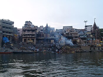
Sankat Mochan Foundation (SMF) is a non-governmental organization devoted to cleaning the pollution of the Ganges and protecting the Ganges river in India. The environmental mission is related to the religious mission of Sankat Mochan Temple and Late Veer Bhadra Mishra was manager of both organizations. Mishra was awarded the United Nations Environment Programme's (UNEP) the "Global 500 Roll of Honour" in 1992, The foundation has been working with Australia-based environmental group, Oz Greene, under a program called "Swatcha Ganga Abhiyan" for over 38 years. It celebrated its silver jubilee on 3–4 November 2007, with two-day event which concluded at the Tulsi Ghat, on the Ganges.

<span class="mw-page-title-main">Water resources in India</span>

Water resources in India includes information on precipitation, surface and groundwater storage and hydropower potential. India experiences an average precipitation of 1,170 millimetres (46 in) per year, or about 4,000 cubic kilometres (960 cu mi) of rains annually or about 1,720 cubic metres (61,000 cu ft) of fresh water per person every year. India accounts for 18% of the world's population and about 4% of the world's water resources. One of the proposed solutions to solve the country's water woes is the Indian rivers interlinking project. Some 80 percent of its area experiences rains of 750 millimetres (30 in) or more a year. However, this rain is not uniform in time or geography. Most of the rains occur during its monsoon seasons, with the northeast and north receiving far more rain than India's west and south. Other than rains, the melting of snow over the Himalayas after the winter season feeds the northern rivers to varying degrees. The southern rivers, however, experience more flow variability over the year. For the Himalayan basin, this leads to flooding in some months and water scarcity in others. Despite an extensive river system, safe clean drinking water as well as irrigation water supplies for sustainable agriculture are in shortage across India, in part because it has, as yet, harnessed a small fraction of its available and recoverable surface water resource. India harnessed 761 cubic kilometres (183 cu mi) (20 percent) of its water resources in 2010, part of which came from unsustainable use of groundwater. Of the water it withdrew from its rivers and groundwater wells, India dedicated about 688 cubic kilometres (165 cu mi) to irrigation, 56 cubic kilometres (13 cu mi) to municipal and drinking water applications and 17 cubic kilometres (4.1 cu mi) to industry.

<span class="mw-page-title-main">Ganges water dispute</span>

A long-standing dispute exists between India and Bangladesh over the appropriate allocation, and development, of the water resources of the Ganges River, which flows from northern India into Bangladesh. The issue had remained a subject of conflict for almost 35 years, with several bilateral agreements and rounds of talks failing to produce results.

<span class="mw-page-title-main">Kalpasar Project</span> Dam

The Kalpasar Project or the Gulf of Khambhat Development Project envisages building a 30 km dam across the Gulf of Khambat in India for establishing a huge fresh water coastal reservoir for irrigation, drinking and industrial purposes. The project with 30 km sea dam will have the capacity to store 10 billion cubic meters fresh water, equating to 25% of Gujarat’s average annual rainwater flow, from the rivers like Narmada, Mahi, Dhadhar, Sabarmati, Limbdi-Bhagovo, and two other minor rivers. A 10 lane road link will also be set up over the dam, greatly reducing the distance between Saurashtra and South Gujarat. The project, which will create world's largest freshwater lake in marine environment, will cost INR90,000 crore or US$12.75 billion excluding the cost of tidal power plant. Project entails construction of the main "Kalpasar dam" across Gulf of Khambat and another Bhadbhut barrage on Narmada river, as well as a canal connecting the two.

<span class="mw-page-title-main">Polavaram Project</span> Dam in Eluru district, Andhra Pradesh

The Polavaram Project is an under construction multi-purpose irrigation project on the Godavari River in the Eluru District and East Godavari District in Andhra Pradesh. The project has been accorded National project status by the Central Government of India. Its reservoir back water spreads up to the Dummugudem Anicut and approx 115 km on Sabari River side. Thus back water spreads into parts of Chhattisgarh and Odisha States. It gives major boost to tourism sector in Godavari Districts as the reservoir covers the famous Papikonda National Park, Polavaram hydro electric project (HEP) and National Waterway 4 are under construction on left side of the river. It is located 40 km to the upstream of Sir Arthur Cotton Barrage in Rajamahendravaram City and 25 km from Rajahmundry Airport.

<span class="mw-page-title-main">Water pollution in India</span> Water pollution in India is mainly due to untreated wastewater discharge into rivers

Water pollution is a major environmental issue in India. The largest source of water pollution in India is untreated sewage. Other sources of pollution include agricultural runoff and unregulated small-scale industry. Most rivers, lakes and surface water in India are polluted due to industries, untreated sewage and solid wastes. Although the average annual precipitation in India is about 4000 billion cubic metres, only about 1122 billion cubic metres of water resources are available for utilization due to lack of infrastructure. Much of this water is unsafe, because pollution degrades water quality. Water pollution severely limits the amount of water available to Indian consumers, its industry and its agriculture.

Save Ganga Movement is a widespread Gandhian non-violent movement supported by saints and popular social activists across the Indian States Uttar Pradesh and Bihar in support of a free Ganga. The movement is supported by Ganga Seva Abhiyanam, Pune-based National Women's Organisation (NWO) besides those of many other like-minded organisations and with the moral support from many religious leaders, spiritual and political, scientists, environmentalists, writers and social activists. Ganga Calling – Save Ganga is another such campaign supported by Indian Council for Enviro-Legal Action (ICELA).

Water scarcity in India is an ongoing water crisis that affects nearly hundreds of million of people each year. In addition to affecting the huge rural and urban population, the water scarcity in India also extensively affects the ecosystem and agriculture. India has only 4% of the world's fresh water resources despite a population of over 1.4 billion people. In addition to the disproportionate availability of freshwater, water scarcity in India also results from drying up of rivers and their reservoirs in the summer months, right before the onset of the monsoons throughout the country. The crisis has especially worsened in the recent years due to climate change which results in delayed monsoons, consequently drying out reservoirs in several regions. Other factors attributed to the shortage of water in India are a lack of proper infrastructure and government oversight and unchecked water pollution.

<span class="mw-page-title-main">Ganges Barrage Project</span>

The Ganges Barrage Project was a proposed project in Bangladesh to hold back rain water of the monsoon season because of the periodic drying up of the Ganges River in Bangladesh due to the Farakka Barrage. It was formally cancelled in 2017.

<span class="mw-page-title-main">Kanh River</span> River in Madhya Pradesh, India

Kanh is a river flowing through Indore, the largest city in the Indian state of Madhya Pradesh. The river started carrying sewage in the early 1990s. Several attempts have been made to clean the river, yet it remains polluted.

The Palla barrage is a barrage located in Palla on the Yamuna-Faridabad canal in Faridabad district of Haryana state in India. This irrigation canal runs to the west of Yaumna through Fridabad, Palwal, Mathura and Agra districts where it terminates in the farms. Palla, Faridabad is not to be confused with Palla, Delhi, a Yamuna pollution monitoring station 23 km upstream of Wazirabad barrage.

<span class="mw-page-title-main">Coastal reservoir</span> Place to store freshwater near seas

A Coastal reservoir is a type of reservoir to store fresh water in a dammed area of a coastal sea near a river delta. Saemanguem in South Korea, Marina Barrage in Singapore, Qingcaosha in China, Plover Cove in Hong Kong, Zuiderzee Works and Delta Works in the Netherlands, and Thanneermukkom Bund in India are a few existing coastal reservoirs.

Namami Gange Programme is an Integrated Conservation Mission, approved as a Flagship Programme by the Union Government of India in June 2014 with a budget outlay of Rs.22,500 crore from 2023-26 to accomplish the twin objectives of effective abatement of pollution, conservation and rejuvenation of National River Ganga. It aimed at engaging with the community which will connect various interest groups including Scientists, Technology companies, Investors and community members. NMCG(National Mission For Clean Ganga) has decided to declare Chacha Chaudhary the popular comic book character, as the mascot of the Namami Gange Programme a statement issued by the Ministry of Jal Shakti. Under the Namami Gange Programme, all the drains falling into the river Saryu in the religious and historical city of Ayodhya are being tapped and contaminated water is being transported to the sewerage treatment plant. The research division of Namami Gange is led by CGanga, established under the aegis of IIT Kanpur.

References

  1. 1 2 Conaway, Cameron (23 September 2015). "The Ganges River is Dying Under the Weight of Modern India". Newsweek . Retrieved 11 April 2017.
  2. 1 2 3 4 5 "Ganga receives 2,900 million ltrs [sic] of sewage daily". www.hindustantimes.com. Archived from the original on 9 September 2015. Retrieved 14 May 2015.
  3. "The WaterHub" . Retrieved 14 May 2015.
  4. Emily Wax (17 June 2007). "A Sacred River Endangered by Global Warming". Washington Post. Retrieved 25 June 2017.
  5. Robert Flynn (15 September 2016). Holy Literary License: The Almighty Chooses Fallible Mortals to Write, Edit, and Translate GodStory. Wings Press. p. 96. ISBN   9781609404666 . Retrieved 13 July 2017.
  6. 1 2 Wohl, Ellen E. 2012. A world of rivers: environmental change on ten of the world's great rivers. Chicago: University of Chicago Press.
  7. "The race to save the river Ganges" . Retrieved 22 February 2021.
  8. Ganga, Yamuna banks cleaned 12 November 2013
  9. "How Modi government went horribly wrong on Ganga rejuvenation". 16 October 2018. Retrieved 17 October 2018.
  10. 1 2 "Namami Ganga development Project gets 2037 crores". IANS. news.biharprabha.com. Retrieved 10 July 2014.
  11. Mohit Dubey (2 August 2016). "RTI revelation: Rs 3000 crore spent on Ganga 'clean-up' without visible results". The Economic Times. Retrieved 25 June 2017.
  12. Wohl, Ellen (29 September 2014), "River Pollution", Environmental Science, Oxford University Press, retrieved 21 February 2023
  13. 1 2 "The Water Page - River Ganga". African water.org. 12 December 1996. Retrieved 9 July 2012.
  14. 1 2 "Sacred Ganga Carries Toxic Pollution". Archived from the original on 14 April 2015. Retrieved 14 May 2015.
  15. "Hindus pilgrims bathe in Ganga - World news - South and Central Asia - NBC News". NBC News. Retrieved 14 May 2015.
  16. "Remove dams & encroachments to clean Ganga". The Times of India . Retrieved 14 May 2015.
  17. "Bangladesh seeks Indian cooperation to build $4 billion Ganges barrage". 3 December 2015. Retrieved 14 February 2016.
  18. "300 dams on the Ganga: A bane or a boon?". IBNLive. Archived from the original on 22 April 2012. Retrieved 14 May 2015.
  19. "CPCB says there is need to regulate withdrawal of water from Ganga". 23 December 2015. Retrieved 24 December 2015.
  20. "Contaminated water a curse for people". The Times of India . 6 May 2013. Archived from the original on 5 July 2015.
  21. "Centre notifies minimum environmental flows for River Ganga" . Retrieved 11 October 2018.
  22. "list of head works (Dams,_Barrages, Weirs, Anicuts, Lifts) on Ganga river". Archived from the original on 21 September 2017. Retrieved 14 May 2015.
  23. "942 dams, barrages in Ganga basin preventing rejuvenation: Environmentalists" . Retrieved 25 November 2018.
  24. "Cleaning the Ganga". Economic and Political Weekly. 54 (39): 7–8. 5 June 2015. Retrieved 25 September 2019.
  25. "Ganga Waterways Project Raises Hopes and Fears" . Retrieved 14 April 2016.
  26. Hamner, Steve; Tripathi, Anshuman; Mishra, Rajesh Kumar; Bouskill, Nik; Broadaway, Susan C.; Pyle, Barry H.; Ford, Timothy E. (1 April 2006). "The role of water use patterns and sewage pollution in incidence of water-borne/enteric diseases along the Ganges river in Varanasi, India". International Journal of Environmental Health Research. 16 (2): 113–132. doi:10.1080/09603120500538226. ISSN   0960-3123. PMID   16546805.
  27. 1 2 Hamner S, Tripathi A, Mishra RK, Bouskill N, Broadaway SC, Pyle BH, Ford TE. "The role of water use patterns and sewage pollution in incidence of water-borne/enteric diseases along the Ganga river in Varanasi, India.", International Journal of Environmental Health Research, Montana, USA, 2006 Apr 16.
  28. 1 2 Daftuar, Swati (25 July 2011). "Polluted flows the Ganga". The Hindu. Chennai, India.
  29. "Indians keep faith with Ganga despite pollution". Archived from the original on 27 January 2010. Retrieved 27 January 2010.
  30. Anirban Ghosh (17 October 2012). "Ganga is now a deadly source of cancer, study says". The Times of India . Archived from the original on 23 May 2013. Retrieved 25 June 2017.
  31. "Ganga river much cleaner than its tarnished image: Study".
  32. Moumita Pal, Santinath Ghosh, Madhumita Mukhopadhyay, Mahau Ghosh. Ganga and Yamuna. "Methyl mercury in fish—a case study on various samples collected from Ganga river at West Bengal.", Environmental Monitoring and Assessment, 8 June 2011.
  33. "Ganga River Dolphin". World Wildlife Fund. Retrieved 14 May 2015.
  34. Malik, R. N., Ghaffar, B., & Hashmi, M. Z. (2013). Trace metals in Ganges softshell turtle (aspideretes gangeticus) from two barrage: Baloki and rasul, pakistan. Environmental Science and Pollution Research International, 20(11), 8263-73. doi : 10.1007/s11356-013-1805-8
  35. "Problems and Solutions for the Ganga River" . Retrieved 14 May 2015.
  36. Naskar, Sudhiti (1 July 2014). "The river where swimming lessons can be a health hazard". BBC News. Retrieved 4 July 2014.
  37. "Wayback Machine" (PDF). Ganga Action Plan.pdf. Archived from the original (PDF) on 9 October 2011. Retrieved 28 December 2023.
  38. "Namami Gange Programme". nmcg.nic.in. Retrieved 1 May 2017.
  39. 1 2 PTI. "Govt to extend Ganga action plan to major rivers". The Hindu. Retrieved 1 May 2017.
  40. "National River Ganga Basin Authority". Archived from the original on 7 October 2011. Retrieved 18 April 2012.
  41. "Composition of NGRBA". Archived from the original on 10 July 2012. Retrieved 18 April 2012.
  42. 1 2 McDermott, Matt (1 June 2011). "World Bank Approves $1 Billion For Ganga River Cleanup". TreeHugger. Retrieved 4 July 2014.
  43. 1 2 Pokharel, Krishna (13 February 2010). "India's Holy Ganges Gets a Cleanup: Government Embarks on $4 Billion Campaign to Treat Heavily Polluted Waters; Devout Hindus Revere River as 'Goddess'". Wall Street Journal . Retrieved 4 July 2014.
  44. "48 industrial units polluting Ganga asked to close down". Patrika Group. 15 July 2014. Retrieved 15 July 2014.
  45. "Approval to Namami Gange - Integrated Ganga Conservation Mission / Programme under National Ganga River Basin Authority".
  46. www.ETInfra.com. "Budgetary outlay for Namami Gange Mission-II Rs 22,500 cr till 2026 - ET Infra". ETInfra.com. Retrieved 16 February 2023.
  47. Luthra, Swati (13 February 2023). "Namami Gange Mission-II approved with budgetary outlay of ₹22,500 cr till 2026". mint. Retrieved 16 February 2023.
  48. "NAMAMI GANGE MISSION-II APPROVED WITH A BUDGETARY OUTLAY OF RS.22,500 CRORE TILL 2026". pib.gov.in. Retrieved 16 February 2023.
  49. Ganga Manthan
  50. "Ganga Manthan tomorrow: National meet to debate over river cleaning". The Indian Express. 6 July 2014. Retrieved 14 May 2015.
  51. "National meet on Ganga cleaning to be held tomorrow". dna. 6 July 2014. Retrieved 14 May 2015.
  52. "Pollution in holy river to be discussed in 'Ganga Manthan'". The Times of India. Retrieved 14 May 2015.
  53. "Existing and planned hydro dams in Nepal" . Retrieved 14 March 2016.
  54. "River water sharing treaty between India and Bangladesh (pages 116 to 120)" (PDF). Retrieved 4 August 2020.
  55. 1 2 3 4 "Catchment area map of lakes Manasarovar and Rakshastal". International Centre for Integrated Mountain Development(ICIMOD). Retrieved 12 August 2015.
  56. "Efficacy of coastal reservoirs to address India's water shortage by impounding excess river flood waters near the coast (page 49)". Archived from the original on 26 July 2018. Retrieved 9 July 2018.
  57. "International Association for Coastal Reservoir Research" . Retrieved 9 July 2018.
  58. "Coastal reservoirs strategy for water resource development-a review of future trend" . Retrieved 9 March 2018.
  59. "Reservoir in sea to end Bengaluru's drinking water problems?". The Times of India . Retrieved 9 March 2018.
  60. 1 2 3 4 5 6 "Multipurpose Freshwater Coastal Reservoirs and Their Role in Mitigating Climate Change" (PDF). Retrieved 23 May 2023.
  61. IWMI Research Report 83. "Spatial variation in water supply and demand across river basins of India" (PDF). Retrieved 23 June 2015.{{cite web}}: CS1 maint: numeric names: authors list (link)
  62. "Ganga & Bramhaputra river's water flow data, India" . Retrieved 26 May 2015.
  63. "Bangladesh, a physically growing country". 18 October 2009. Retrieved 14 May 2015.
  64. "India is not running out of water, water is running out of India". 26 March 2017. Retrieved 9 July 2018.
  65. "Water Quality Database of Indian rivers, MoEF" . Retrieved 17 April 2021.
  66. "Meri Ganga | National Ganga Portal". meriganga.com. Retrieved 1 May 2017.
  67. PTI. "Clean Ganga Fund: Rs. 66 crore and counting". The Hindu. Retrieved 1 May 2017.
  68. "About National Mission for Clean Ganga". NMCG. 12 August 2011. Retrieved 13 October 2016.
  69. "Modi Cabinet news: Meet Modi's formidable force in run-up to 2019 general elections". The Times of India. TNN. 4 September 2017. Retrieved 29 October 2020.
  70. India, National Mission for Clean Ganga (NMCG), Ministry of Jal Shakti, Department of Water Resources, River Development & Ganga Rejuvenation, Government of. "नमामि गंगे". National Mission for Clean Ganga (NMCG), Ministry of Jal Shakti, Department of Water Resources, River Development & Ganga Rejuvenation, Government of India. Retrieved 31 October 2020.{{cite web}}: CS1 maint: multiple names: authors list (link)
  71. Desk, India com News (29 September 2020). "Namami Gange Mission Most Comprehensive River Conservation Program, Says PM Modi". India News, Breaking News, Entertainment News | India.com. Retrieved 31 October 2020.
  72. Dube, Priyanka (14 June 2011). "Sadhu dies after a 73-day fast to save Ganga". ibnlive.in.com. CNN-IBN. Archived from the original on 16 June 2011. Retrieved 14 June 2011. Swami Nigamanand
  73. "Shivanand breaks fast after forcing curb on Ganga bed quarrying". The Pioneer . CMYK Printech. Archived from the original on 16 May 2012.
  74. "'The govt doesn't care for the issue Prof GD Agrawal is fasting for'". Tehelka.com. Retrieved 14 May 2015.
  75. Slater, Joanna. "Environmental activist fasts to death over fate of India's Ganges River". Washington Post. Retrieved 20 June 2020.