Natural disasters in India

Last updated
Disaster-prone regions in India. India climatic disaster risk map en.svg
Disaster-prone regions in India.
Map showing winds zones, shaded by distribution of average speeds of prevailing winds. India wind zone map en.svg
Map showing winds zones, shaded by distribution of average speeds of prevailing winds.

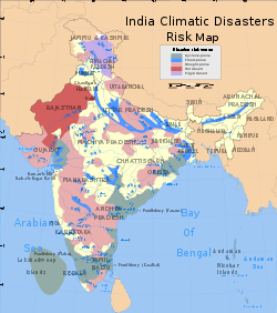
Natural calamities in India, many of them related to the climate of India, cause massive losses of life and property. Droughts, flash floods, cyclones, avalanches, landslides brought by torrential rains, and snowstorms pose the greatest threats. A natural disaster might be caused by earthquakes, flooding, volcanic eruption, landslides, hurricanes etc. In order to be classified as a disaster, it will need to have a profound environmental effect and/or human loss and frequently incurs a financial loss. [1] Other dangers include frequent summer dust storms, which usually track from north to south; they cause extensive property damage in North India [2] and deposit large amounts of dust and dirt from arid regions. Hail is also common in parts of India, causing severe damage to standing crops such as rice and wheat and many more crops and effects many people.

Contents

Landslides and avalanches

Landslides are very common in the Lower Himalayas. The young age of the region's hills results in rock formations, which are susceptible to slippages. Rising population and development pressures, particularly from logging and tourism, cause deforestation. The result is denuded hillsides which exacerbate the severity of landslides; since tree, cover impedes the downhill flow of water. [3] Parts of the Western Ghats also suffer from low-intensity landslides. Avalanches occurrences are common in Kashmir, Himachal Pradesh, and Sikkim etc. Landslides in India are also highly dangerous as many Indian families and farmers reside in the hills or mountains.

Floods in India

Floods are the most common natural disaster in India. The heavy southwest monsoon rains cause the Brahmaputra and other rivers to distend their banks, often flooding surrounding areas. Though they provide rice paddy farmers with a largely dependable source of natural irrigation and fertilisation, the floods can kill thousands and displace millions. Excess, erratic, or untimely monsoon rainfall may also wash away or otherwise ruin crops. [4] [5] Almost all of India is flood-prone, and extremely precipitation events, such as flash floods and torrential rains, have become increasingly common in central India over the past several decades, coinciding with rising temperatures. Meanwhile, the annual precipitation totals have shown a gradual decline, due to a weakening monsoon circulation [6] as a result of the rapid warming in the Indian Ocean [7] and a reduced land-sea temperature difference. This means that there are more extreme rainfall events intermittent with longer dry spells over central India in the recent decades.

Cyclones in India

The Intertropical Convergence Zone may affect thousands of Indians living in the coastal regions. Tropical cyclogenesis is particularly common in the northern reaches of the Indian Ocean in and around the Bay of Bengal. Cyclones bring with them heavy rains, storm surges, and winds that often cut affected areas off from relief and supplies. In the North Indian Ocean Basin, the cyclone season runs from April to December, with peak activity between May and November. [8] Each year, an average of eight storms with sustained wind speeds greater than 63 kilometres per hour (39 mph) form; of these, two strengthen into true tropical cyclones, which have sustained gusts greater than 117 kilometres per hour (73 mph). On average, a major (Category 3 or higher) cyclone develops every other year. [9] [10]

During summer, the Bay of Bengal is subject to intense heating, giving rise to humid and unstable air masses that produce cyclones. Many powerful cyclones, including the 1737 Calcutta cyclone, the 1970 Bhola cyclone, the 1991 Bangladesh cyclone, the 1999 Odisha cyclone, and 2019s Cyclone Fani in Odisha and Cyclone Vayu in Gujarat, have led to widespread devastation along parts of the eastern coast of India and neighboring Bangladesh. Widespread death and property destruction are reported every year in exposed Tamil Nadu, and West Bengal. India's western coast, bordering the more placid Arabian Sea, experiences cyclones only rarely; these mainly strike Gujarat and, less frequently, Kerala and sometimes Odisha.

In terms of damage and loss of life, the 1999 Odisha cyclone, a super cyclone that struck Odisha on 29 October 1999, was the worst in more than a quarter-century. With peak winds of 160 miles per hour (257 km/h), it was the equivalent of a Category 5 hurricane. [11] Almost two million people were left homeless; [12] another 20 million people's lives were disrupted by the cyclone. [12] Officially, 9,803 people died from the storm; [11] unofficial estimates place the death toll at over 10,100. [12]

In terms of damage and asset destruction, Cyclone Amphan, [13] a super cyclone that struck West Bengal, Odisha and Bangladesh on 20 May 2020 is, as of that date, the worst in India in the 21st century. With peak winds of 260 kilometres per hour (162 mph) to 280 kilometres per hour (174 mph), it was the equivalent of a Category 5 hurricane. [11] Almost 5 million (50 lakh) people are left homeless in West Bengal, Odisha and Bangladesh ; [13] another 10 million (1 crore) people's lives were disrupted by the cyclone. Officially, 128 people died from the storm. Official damage and asset destruction estimate is 13.40 to 13.69 billion US Dollars ; [14] it is the costliest and most damaging cyclone ever to occur in the Bay of Bengal.

2021 Cyclone Tauktae killed at least 104 people, the highest in a decade. [15]

Climate change impacts on environment

Monsoon

The Indian meteorological department has declared that water cycle will be more intense, with higher annual average rainfall as well increased drought in future years. [16] A 20% rise in monsoon over most states is also predicted. [17] A 2 °C rise in global average temperature will make Indian monsoon highly unpredictable. [18] At 4 °C an extremely wet monsoon which currently has a 1 in 100 year's chance will occur in every 10 years by 2100. Extremes in maximum and minimum temperatures and precipitation will increase particularly over western coast and central and north-east India. [19] The dry years are expected to be drier and wet years wetter due to Climate Change.

Rivers and glaciers

The per capital availability of freshwater in India is expected to drop below 1000 cubic meters by 2025 because of population growth and climate change. River basins of Kaveri, Penna, Mahi, Sabarmati, Tapi, Luni and few others are already water scarce. Krishna and Subarnarekha may become so by 2025. High population density, coastal flooding and saltwater intrusion and exposure to storm surges makes Ganga, Godavari, Krishna and Mahanadi coastal river deltas "hotspots" of climate change vulnerability. [16]
Glaciers are the main source of water for the Himalayan Rivers such as Ganga, Brahmaputra and Indus. 67% of Himalayan glaciers have receded in the past decade and continue to diminish with increasing rates. The Ganga and the Indus are likely to become water scarce by 2025. [20] Since 1962, the overall glacier area has reduced by 21% from 2077 km2 to 1628 km2. This will lead to water shortages becoming acuter with time and may endanger food security and energy generation. [21]

Sea level rise

Rise in sea temperature and sea level leads to loss of marine ecosystems and biodiversity, salination, erosion and flooding and also increases occurrence and intensity of storms along entire shoreline. Climate Change impacts are already observed in submergence of coastal lands in the Sundarbans, [22] loss of wetlands [23] and of coral reefs by bleaching, [24] and an estimated sea level rise of 1.06 - 1.75 mm/year.[ citation needed ] Low-end scenarios estimate sea levels in Asia will be at least 40  cm higher by 2100. The IPCC calculates that it would expose 13–94 million people to flooding, with about 60% of this total in South Asia. A sea-level rise of 100 cm would inundate 5,763 cubic km of India's landmass. [25] It will severely affect populations in megacities like Mumbai, Kolkata and Chennai due to land submergence and extreme weather events. [26] Increase in sea surface temperature increases frequency, intensity, scale and destructive power of tropical cyclones. [27]

Droughts, heatwaves and storms

500Mha land in the Asia Pacific region is already experiencing land degradation. [28] The summers have already become more intense in India with some regions regularly reporting temperatures around 47 °C. [29] In the last four years, India has seen as many as over 4,620 deaths caused by heat waves, according to data published by the Ministry of Earth Sciences, Government of India. [30] Indian Meteorological Department declared that the storm that hit northern India in May 2018 was severe and their frequency could increase due to global warming. This is due to an increase in the intensity of the wind and dryness of the soil which increases the intensity of dust storms. The rise in land surface temperature will be more pronounced in the northern part of India. A recent study reports that summers could last up to 8 months in the Gangetic plain by 2070 if the global temperature increases beyond 2 °C. [31] Increasingly severe and frequent Heat waves may substantially increase mortality and death incidences. [32] Such warming conditions along with the water scarcities aggravates the impacts of droughts. [33]

Disaster response agencies

See also

Citations

  1. Goswami BN, Venugopal V, Sengupta D, Madhusoodanan MS, Xavier PK (2006). "Increasing trend of extreme rain events over India in a warming environment". Science. 314 (5804): 1442–1445. Bibcode:2006Sci...314.1442G. doi:10.1126/science.1132027. PMID   17138899. S2CID   43711999.
  2. Balfour 1976 , p. 995.
  3. Allaby 1998 , p. 26.
  4. Allaby 1998 , p. 42.
  5. Allaby 1998 , p. 15.
  6. Roxy, Mathew Koll; Ritika, Kapoor; Terray, Pascal; Murtugudde, Raghu; Ashok, Karumuri; Goswami, B. N. (2015-06-16). "Drying of Indian subcontinent by rapid Indian Ocean warming and a weakening land-sea thermal gradient". Nature Communications. 6: 7423. Bibcode:2015NatCo...6.7423R. doi: 10.1038/ncomms8423 . PMID   26077934. Archived from the original on 2019-09-01. Retrieved 2019-09-01.
  7. Roxy, Mathew Koll; Ritika, Kapoor; Terray, Pascal; Masson, Sébastien (2014-09-11). "The Curious Case of Indian Ocean Warming" (PDF). Journal of Climate. 27 (22): 8501–8509. Bibcode:2014JCli...27.8501R. doi:10.1175/JCLI-D-14-00471.1. ISSN   0894-8755. S2CID   42480067. Archived (PDF) from the original on 2019-09-03. Retrieved 2019-06-29.
  8. Atlantic Oceanographic and Meteorological Laboratory, Hurricane Research Division. "Frequently Asked Questions: When is hurricane season?". NOAA. Archived from the original on 2006-07-18. Retrieved 2006-07-25.
  9. Atlantic Oceanographic and Meteorological Laboratory, Hurricane Research Division. "Frequently Asked Questions: When is hurricane season?". National Oceanic and Atmospheric Administration. Archived from the original on July 18, 2006. Retrieved July 25, 2006.
  10. Atlantic Oceanographic and Meteorological Laboratory, Hurricane Research Division. "Frequently Asked Questions: What are the average, most, and least tropical cyclones occurring in each basin?". NOAA. Archived from the original on 2012-07-31. Retrieved 2006-07-25.
  11. 1 2 3 "Tropical Cyclone 05B" (PDF). Naval Maritime Forecast Center (Joint Typhoon Warning Center). Archived from the original (PDF) on 2011-06-07. Retrieved 2007-04-08.
  12. 1 2 3 "1999 Supercyclone of Orissa". BAPS Care International. 2005. Archived from the original on 2007-09-27. Retrieved 2007-04-08.
  13. 1 2 "2020 Supercyclone Amphhan". The Times of India . 2020. Archived from the original on 2020-06-04. Retrieved 2020-06-05.
  14. "US Dollar". Archived from the original on 2020-05-22. Retrieved 2020-06-05.
  15. "Explained: How does Tauktae compare with other cyclones in severity and damage?". The Indian Express. 2021-05-27. Archived from the original on 2021-06-07. Retrieved 2021-09-19.
  16. 1 2 http://www.indiaenvironmentportal.org.in/files/india-climate-5-water-DEFRA.pdf Archived 2018-07-03 at the Wayback Machine [ bare URL PDF ]
  17. Sathaye, Jayant; Shukla, Priyadarshi; H. Ravindranath, N (30 November 2005). "Climate change, sustainable development and India: Global and national concerns". Curr Sci. 90 via ResearchGate.
  18. http://www.indiaenvironmentportal.org.in/files/cc10.pdf Archived 2018-07-03 at the Wayback Machine [ bare URL PDF ]
  19. "India: Climate Change Impacts". Archived from the original on 2018-07-03. Retrieved 2018-07-03.
  20. "India will be the hotspot of water crisis by 2025: UN". www.indiawaterportal.org. Archived from the original on 2018-07-03. Retrieved 2018-07-03.
  21. http://www.saded.in/PDF%20Files/Kulkarni_GW_Effect_HimalayanGlaciers_Shrinkage.pdf Archived 2018-11-23 at the Wayback Machine [ bare URL PDF ]
  22. "Sinking Sundarbans islands underline climate crisis". 17 January 2018. Archived from the original on 3 July 2018. Retrieved 3 July 2018.
  23. Sarkar, uttam; Borah, Bibha (28 June 2017). "Flood plain wetland fisheries of India: with special reference to impact of climate change". Wetlands Ecology and Management. 26: 1–15. doi:10.1007/s11273-017-9559-6. S2CID   3807851 via ResearchGate.
  24. Hoegh-Guldberg, Ove; Poloczanska, Elvira S.; Skirving, William; Dove, Sophie (8 June 2018). "Coral Reef Ecosystems under Climate Change and Ocean Acidification". Frontiers in Marine Science. 4. doi: 10.3389/fmars.2017.00158 .
  25. "10.4.3 Coastal and low lying areas – AR4 WGII Chapter 10: Asia". www.ipcc.ch. Archived from the original on 2018-07-03. Retrieved 2018-07-03.
  26. https://mpra.ub.uni-muenchen.de/22062/1/MPRA_paper_22062.pdf Archived 2017-08-13 at the Wayback Machine [ bare URL PDF ]
  27. Sun, Yuan; Zhong, Zhong; Li, Tim; Yi, Lan; Hu, Yijia; Wan, Hongchao; Chen, Haishan; Liao, Qianfeng; Ma, Chen; Li, Qihua (15 August 2017). "Impact of Ocean Warming on Tropical Cyclone Size and Its Destructiveness". Scientific Reports. 7 (1): 8154. Bibcode:2017NatSR...7.8154S. doi:10.1038/s41598-017-08533-6. PMC   5557849 . PMID   28811627.
  28. Ravindranath, Nijavalli H.; Sathaye, Jayant A. (11 April 2006). Climate Change and Developing Countries. Springer Science & Business Media. ISBN   9780306479809. Archived from the original on 17 January 2023. Retrieved 1 December 2020 via Google Books.
  29. "India records its hottest day ever as temperature hits 51C (that's 123.8F)". the Guardian. Agence France-Presse. 20 May 2016. Archived from the original on 23 May 2016. Retrieved 3 July 2018.
  30. "India's killer heatwaves claim 4620 deaths in last four years". 23 April 2017. Archived from the original on 3 July 2018. Retrieved 3 July 2018.
  31. "Effects of climate change: If global warming continues, summers in India could last for 8 months by 2070, say researchers – Firstpost". www.firstpost.com. 11 January 2018. Archived from the original on 3 July 2018. Retrieved 3 July 2018.
  32. "Dust storms may increase in India due to climate change". india.mongabay.com. 2018-05-08. Archived from the original on 2018-07-03. Retrieved 2018-07-03.
  33. Swain, S; et al. (2017). "Application of SPI, EDI and PNPI using MSWEP precipitation data over Marathwada, India". 2017 IEEE International Geoscience and Remote Sensing Symposium (IGARSS). Vol. 2017. pp. 5505–5507. doi:10.1109/IGARSS.2017.8128250. ISBN   978-1-5090-4951-6. S2CID   26920225.

Further reading

General overview
Reports
Resources on Natural Disasters
Maps, imagery, and statistics
Forecasts

Related Research Articles

<span class="mw-page-title-main">Extreme weather</span> Unusual, severe or unseasonal weather

Extreme weather includes unexpected, unusual, severe, or unseasonal weather; weather at the extremes of the historical distribution—the range that has been seen in the past. Extreme events are based on a location's recorded weather history. They are defined as lying in the most unusual ten percent. The main types of extreme weather include heat waves, cold waves and heavy precipitation or storm events, such as tropical cyclones. The effects of extreme weather events are economic costs, loss of human lives, droughts, floods, landslides. Severe weather is a particular type of extreme weather which poses risks to life and property.

<span class="mw-page-title-main">Climate of India</span> Overview of climatic conditions in India

The climate of India consists of a wide range of weather conditions across a vast geographic scale and varied topography. Based on the Köppen system, India hosts six major climatic sub types, ranging from arid deserts in the west, alpine tundra and glaciers in the north, and humid tropical regions supporting rain forests in the southwest and the island territories. Many regions have starkly different microclimates, making it one of the most climatically diverse countries in the world. The country's meteorological department follows the international standard of four seasons with some local adjustments: winter, summer, monsoon or rainy season, and a post-monsoon period.

<span class="mw-page-title-main">North Indian Ocean tropical cyclone</span>

In the Indian Ocean north of the equator, tropical cyclones can form throughout the year on either side of the Indian subcontinent, although most frequently between April and June, and between October and December.

<span class="mw-page-title-main">2005 North Indian Ocean cyclone season</span> Cyclone season in the North Indian ocean

The 2005 North Indian Ocean cyclone season caused much devastation and many deaths in Southern India despite the storms’ weakness. The basin covers the Indian Ocean north of the equator as well as inland areas, sub-divided by the Arabian Sea and the Bay of Bengal. Although the season began early with two systems in January, the bulk of activity was confined from September to December. The official India Meteorological Department tracked 12 depressions in the basin, and the unofficial Joint Typhoon Warning Center (JTWC) monitored two additional storms. Three systems intensified into a cyclonic storm, which have sustained winds of at least 63 km/h (39 mph), at which point the IMD named them.

<span class="mw-page-title-main">1992 North Indian Ocean cyclone season</span>

The 1992 North Indian Ocean cyclone season was unofficially the most active year on record for the basin, with 10 tropical storms developing, according to the Joint Typhoon Warning Center (JTWC). There are two main seas in the North Indian Ocean – the Bay of Bengal to the east of the Indian subcontinent – and the Arabian Sea to the west of India. The official Regional Specialized Meteorological Centre in this basin is the India Meteorological Department (IMD), while the JTWC releases unofficial advisories. An average of four to six storms form in the North Indian Ocean every season with peaks in May and November. Cyclones occurring between the meridians 45°E and 100°E are included in the season by the IMD.

<span class="mw-page-title-main">2006 North Indian Ocean cyclone season</span> North Indian Ocean tropical cyclone season

The 2006 North Indian Ocean cyclone season had no bounds, but cyclones tend to form between April and December, with peaks in May and November. These dates conventionally delimit the period of each year when most tropical cyclones form in the northern Indian Ocean.

<span class="mw-page-title-main">2004 North Indian Ocean cyclone season</span> North Indian Ocean tropical cyclone season

The 2004 North Indian Ocean cyclone season was the first in which tropical cyclones were officially named in the basin. Cyclone Onil, which struck India and Pakistan, was named in late September. The final storm, Cyclone Agni, was also named, and crossed into the southern hemisphere shortly before dissipation. This storm became notable during its origins and became one of the storms closest to the equator. The season was fairly active, with ten depressions forming from May to November. The India Meteorological Department designated four of these as cyclonic storms, which have maximum sustained winds of at least 65 km/h (40 mph) averaged over three minutes. The Joint Typhoon Warning Center also issued warnings for five of the storms on an unofficial basis.

<span class="mw-page-title-main">2003 North Indian Ocean cyclone season</span> North Indian Ocean tropical cyclone season

The 2003 North Indian Ocean cyclone season was the last season that tropical cyclones were not publicly labeled by India Meteorological Department (IMD). Also was mostly focused in the Bay of Bengal, where six of the seven depressions developed. The remaining system was a tropical cyclone that developed in the Arabian Sea in November, which was also the only system that did not affect land. There were three cyclonic storms, which was below the average of 4–6. Only one storm formed before the start of the monsoon season in June, although it was also the most notable. On May 10, a depression formed in the central Bay of Bengal, and within a few days became a very severe cyclonic storm. After it stalled, it drew moisture from the southwest to produce severe flooding across Sri Lanka, killing 254 people and becoming the worst floods there since 1947. Damage on the island totaled $135 million (2003 USD). The storm eventually made landfall in Myanmar on May 19. It is possible that the storm contributed to a deadly heat wave in India due to shifting air currents.

<span class="mw-page-title-main">1995 North Indian Ocean cyclone season</span> Cyclone season 1995 in the North Indian ocean

The 1995 North Indian Ocean cyclone season was below-average and was primarily confined to the autumn months, with the exception of three short-lived deep depressions in May. There were eight depressions in the basin, which is Indian Ocean north of the equator. The basin is subdivided between the Bay of Bengal and the Arabian Sea on the east and west coasts of India, respectively. Storms were tracked by the India Meteorological Department (IMD), which is the basin's Regional Specialized Meteorological Center, as well as the American-based Joint Typhoon Warning Center (JTWC) on an unofficial basis.

<span class="mw-page-title-main">Climate of Asia</span> Overview of the climate of Asia

The climate of Asia is dry across its southwestern region. Some of the largest daily temperature ranges on Earth occur in the western part of Asia. The monsoon circulation dominates across the southern and eastern regions, due to the Himalayas forcing the formation of a thermal low which draws in moisture during the summer. The southwestern region of the continent experiences low relief as a result of the subtropical high pressure belt; they are hot in summer, warm to cool in winter, and may snow at higher altitudes. Siberia is one of the coldest places in the Northern Hemisphere, and can act as a source of arctic air mass for North America. The most active place on Earth for tropical cyclone activity lies northeast of the Philippines and south of Japan, and the phase of the El Nino-Southern Oscillation modulates where in Asia landfall is more likely to occur. Many parts of Asia are being impacted by climate change.

<span class="mw-page-title-main">Tropical cyclones in India</span>

India is a country in the north of Indian Ocean that is the most vulnerable to getting hit by tropical cyclones in the basin, from the east or from the west. On average, 2–3 tropical cyclones make landfall in India each year, with about one being a severe tropical cyclone or greater.

<span class="mw-page-title-main">2014 North Indian Ocean cyclone season</span> North Indian Ocean tropical cyclone season

The 2014 North Indian Ocean cyclone season was an event in the annual cycle of tropical cyclone formation. The season included two very severe cyclonic storms, both in October, and one other named cyclonic storm, classified according to the tropical cyclone intensity scale of the India Meteorological Department. Cyclone Hudhud is estimated to have caused US$3.58 billion in damage across eastern India, and more than 120 deaths.

<span class="mw-page-title-main">2003 Sri Lanka cyclone</span> Tropical cyclone

In May 2003, a tropical cyclone officially called Very Severe Cyclonic Storm BOB 01 produced the worst flooding in Sri Lanka in 56 years. The first storm of the 2003 North Indian Ocean cyclone season, it developed over the Bay of Bengal on May 10. Favorable environmental conditions allowed the system to intensify steadily while moving northwestward. The storm reached peak maximum sustained winds of 140 km/h (85 mph) on May 13, making it a very severe cyclonic storm according to the India Meteorological Department (IMD), which is the official Regional Specialized Meteorological Center for the basin. The cyclone drifted north over the central Bay of Bengal, gradually weakening due to heightened wind shear. Turning eastward, the storm deteriorated to a deep depression on May 16 before it curved northeastward and re-intensified into a cyclonic storm. It came ashore in western Myanmar and dissipated over land the following day.

<span class="mw-page-title-main">2015 North Indian Ocean cyclone season</span> North Indian Ocean tropical cyclone season

The 2015 North Indian Ocean cyclone season was an event in the annual cycle of tropical cyclone formation. The North Indian Ocean cyclone season has no official bounds, but cyclones tend to form between months of April and December, with the peak from May to November. These dates conventionally delimit the period of each year when most tropical cyclones form in the northern Indian Ocean.

<span class="mw-page-title-main">Cyclone Roanu</span>

Cyclonic Storm Roanu was a relatively weak tropical cyclone that caused severe flooding in Sri Lanka and Bangladesh during May 2016. It is the first tropical cyclone of the annual cyclone season. Roanu originated from a low-pressure area that formed south of Sri Lanka, which gradually drifted north and intensified into a cyclonic storm on 19 May. However, wind shear and land interaction caused it to weaken slightly, before reintensifying as it accelerated towards the coast of Bangladesh.

<span class="mw-page-title-main">2017 North Indian Ocean cyclone season</span> North Indian Ocean tropical cyclone season

The 2017 North Indian Ocean cyclone season was a below average yet deadly season in the annual cycle of tropical cyclone formation. This season produced only three named storms, of which one only intensified into a very severe cyclonic storm. The North Indian Ocean cyclone season has no official bounds but cyclones tend to form between April and December with the two peaks in May and November. These dates conventionally delimit the period of each year when most tropical cyclones form in the northern Indian Ocean. The season began with the formation Cyclone Maarutha on April 15 and ended with the dissipation of a deep depression on December 9.

<span class="mw-page-title-main">2018 North Indian Ocean cyclone season</span> North Indian Ocean tropical cyclone season

The 2018 North Indian Ocean cyclone season was one of the most active North Indian Ocean cyclone seasons since 1992, with the formation of fourteen depressions and seven cyclones. The North Indian Ocean cyclone season has no official bounds, but cyclones tend to form between April and December, with the two peaks in May and November. These dates conventionally delimit the period of each year when most tropical cyclones form in the northern Indian Ocean.

<span class="mw-page-title-main">Tropical cyclones in 2017</span>

During 2017 tropical cyclones formed within seven different tropical cyclone basins, located within various parts of the Atlantic, Pacific and Indian Oceans. During the year, a total of 146 tropical cyclones had formed. 88 tropical cyclones had been named by either a Regional Specialized Meteorological Center (RSMC) or a Tropical Cyclone Warning Center (TCWC).

<span class="mw-page-title-main">Tropical cyclones in 2014</span>

During 2014, tropical cyclones formed within seven different tropical cyclone basins, located within various parts of the Atlantic, Pacific and Indian Oceans. During the year, a total of 117 tropical cyclones had formed this year to date. 79 tropical cyclones had been named by either a Regional Specialized Meteorological Center (RSMC) or a Tropical Cyclone Warning Center (TCWC). The most active basin in 2014 was the Western Pacific, which documented 23 named systems, while the Eastern Pacific, despite only amounting to 22 named systems, was its basin's most active since 1992. Conversely, both the North Atlantic hurricane and North Indian Ocean cyclone had a below average season numbering 9 and 3, respectively. Activity across the southern hemisphere's three basins—South-West Indian, Australian, and South Pacific—was spread evenly, with each region recording seven named storms apiece. So far, 26 Category 3 tropical cyclones formed, including ten Category 5 tropical cyclones in the year, becoming as the third-most intense tropical cyclone activity on record, only behind with 1997 and 2018. The accumulated cyclone energy (ACE) index for the 2014, as calculated by Colorado State University (CSU) was 724 units.

<span class="mw-page-title-main">Cyclone Titli</span> Deadly tropical cyclone that impacted the East coast of India

Very Severe Cyclonic Storm Titli was a deadly and destructive tropical cyclone that caused extensive damage to Eastern India in October 2018. Titli was the twelfth depression and fifth named storm to form in the 2018 North Indian Ocean cyclone season. Titli originated from a low pressure area in the Andaman Sea on October 7. With warm sea surface temperatures and low wind shear, the low developed into a depression on October 8 in the central Bay of Bengal. It was tracked and followed by the India Meteorological Department (IMD), which also issued warnings and notices for the public. Titli continued to intensify at it moved toward the southeast Indian coast, becoming a very severe cyclonic storm, equivalent to a minimal hurricane on the Saffir–Simpson scale. It attained the intensity at the same time Cyclone Luban in the Arabian Sea was at the same intensity, marking the first instance since 1977 of simultaneous storms. The IMD estimated peak winds of 150 km/h (95 mph), while the American-based Joint Typhoon Warning Center (JTWC) estimated peak winds of 195 km/h (120 mph). Late on October 10, Titli made landfall in Andhra Pradesh, and it quickly weakened over land as it turned to the northeast. It degenerated into a remnant low on October 12.