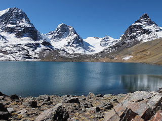
Q'ara Quta is a lake on the western side of the Cordillera Real of Bolivia located in the La Paz Department, Los Andes Province, Batallas Municipality, Comunidad Alto Peñas. It lies north-west of the Kunturiri massif, between the lakes Wichhu Quta (5 km) in the south-west and Khotia Quta and Janq'u Quta in the north-east. The lakes are connected by Jach'a Jawira, a river which originates near the mountain Wila Lluxita and flows down to Lake Titicaca. Q'ara Quta is situated at a height of about 4,400 metres (14,400 ft), about 5 km long and 0,65 km at its widest point.

Sura K'uchu is a region in the Cordillera Occidental in the Andes of Bolivia. It is located in the Oruro Department, Sajama Province, Turku Municipality, Chachakumani Canton. Sura K'uchu is situated south-east of the Uqi Uqini volcano and north-east of the volcano Umurata. It lies south of National Route 4 near the Chungara-Tambo Quemado pass. The river Jaruma originates here. It flows to the north-east as an affluent of the Sajama River.

Ch'uxña Quta is a mountain in the Bolivian Andes, about 4,920 metres (16,142 ft) high. It lies in the Kimsa Cruz mountain range, west of Wallatani Lake. It is situated in the La Paz Department, Loayza Province, Malla Municipality.
Taypi K'uchu is a 4,928-metre-high (16,168 ft) mountain in the Cordillera Real in the Andes of Bolivia. It is situated in the La Paz Department, Los Andes Province, Batallas Municipality. Taypi K'uchu lies south-west of the mountains Jach'a Juqhu and Ch'iyar T'ikhi and north-west of Qullqi Chata.

Qullqi Warani is a mountain in the Oruro Department in Bolivia at the border with Chile, north-west of the extinct Sajama volcano. It is situated in the Sajama Province, in the west of the Curahuara de Carangas Municipality. According to the Bolivian IGM map 1:50,000 'Nevados Payachata Hoja 5739-I' it lies entirely on Bolivian terrain. Qullqi Warani lies south-west of the mountains Jisk'a Kunturiri and Patilla Pata, north of Phaq'u Q'awa and south-east of Kunturiri. The little lakes Q'asiri Quta (Khasiri Kkota) and Sura Pata (Sora Pata, Sorapata) lie at its feet, east and north of it.
Phaq'u Q'awa is a mountain in the Cordillera Occidental in the Andes of Bolivia, about 5,380 metres (17,651 ft) high. It is situated in the Oruro Department, Sajama Province, in the west of the Curahuara de Carangas Municipality, northwest of the extinct Sajama volcano. It lies south of Qullqi Warani.
Kimsa Willk'i is a 5,032-metre-high (16,509 ft) mountain in the Bolivian Andes. It is located in the La Paz Department, Inquisivi Province, in the south of the Quime Municipality. Kimsa Willk'i is situated south-east of the mountain Wisk'achani. The lakes Muyu Quta (Muyu Khota) and Wiska Quta (Wisca Khota) lie at its feet, north-west of it.
Wila Willk'i is a 4,630-metre-high (15,190 ft) mountain in the Bolivian Andes. It is located in the La Paz Department, Loayza Province, Malla Municipality. Wila Willk'i is situated northwest of Malla and a mountain named Malla Qullu.
Jach'a Qullu is a 4,390-metre-high (14,403 ft) mountain in the Bolivian Andes. It is located in the La Paz Department, Loayza Province, Malla Municipality. Jach'a Qullu is situated south-west of the mountains Wila Willk'i, Malla Qullu and Janq'u Qalani (Jankho Khalani). It lies west of Malla. The river Jach'a K'uchu Jawira flows along the northern slopes of Jach'a Qullu.
Quta Qutani is a mountain in the Bolivian Andes, about 4,600 metres (15,092 ft) high. It is located in the La Paz Department, Loayza Province, Malla Municipality. Quta Qutani is situated northwest of the little town of Malla and the mountains named Malla Qullu and Wila Willk'i and northeast of Kunturiri. The Jach'a K'uchu Jawira (Jachcha Khuchu Jahuira) originates east of the mountain. It flows along its southeastern slope and to the southwest as a tributary of the Malla Jawira.
Malla Jawira is a river in the La Paz Department in Bolivia. It is a right tributary of the Luribay River whose waters flow to the La Paz River.
Uyu K'uchu is a mountain in the Cordillera Real in the Andes of Bolivia, about 4,800 metres (15,748 ft) high. It is situated in the La Paz Department, Murillo Province, La Paz Municipality. Uyu K'uchu lies south of the mountain Sankayuni and north-east of the mountain Kunturiri.
Ch'uch'u Jawira is a Bolivian river in the La Paz Department, Larecaja Province, Sorata Municipality. Its waters flow the Kaka River which belongs to the watershed of the Beni River.
Wankar Quta Qullu is a mountain in the Andes of Bolivia, about 4,900 metres (16,076 ft) high. It is situated in the La Paz Department, Larecaja Province, Sorata Municipality, north of the main range of the Cordillera Real. Wankar Quta Qullu lies northeast of the mountain Wila Wilani. South of it there is a lake named Q'asiri Quta. A little river named Q'asiri Jawira originates here. It flows to Ch'uch'u Jawira in the south.
Ch'uxña Quta is a 4,907-metre-high (16,099 ft) mountain in the Andes of Bolivia. It is situated in the La Paz Department, Larecaja Province, Sorata Municipality. Ch'uxña Quta lies in the northern extensions of the Cordillera Real southeast of the mountains Ch'uch'u and Ch'uch'u Apachita and northwest of Llawi Imaña.

Jach'a K'uchu is a mountain in the Andes of Peru, about 5,200 metres (17,060 ft) high. It is located in the Moquegua Region, Mariscal Nieto Province, Carumas District, and in the Puno Region, El Collao Province, Santa Rosa District. It lies southwest of Qiwña Milluku and northwest of Kurawara (Curahuara). The Janq'u Jaqhi River originates on the east side of the mountain. It flows to the southeast.
Llust'a K'uchu is a mountain in the Andes of southern Peru, about 4,800 metres (15,748 ft) high. It is situated in the Puno Region, El Collao Province, Santa Rosa District.
Ananta Cucho is a mountain in the Vilcanota mountain range in the Andes of Peru, about 5,100 metres (16,732 ft) high. It is located in the Puno Region, Carabaya Province, on the border of the districts of Corani and Ollachea. Ananta Cucho lies southwest of Yurac Salla, northwest of Taruca Sayana and east of Llusca Ritti and Jori Pintay.
Soracucho is a mountain in the Vilcanota mountain range in the Andes of Peru, about 5,000 metres (16,404 ft) high. It is in the Cusco Region, Canchis Province, San Pablo District. Soracucho lies southwest of Collpacucho and south of Yurac Uno Cunca. The Pumanuta River, an important tributary of the Vilcanota River, flows along its northern slope.
Jach'a K'uchu is a 4,508-metre-high (14,790 ft) mountain in a volcanic field in the Cordillera Occidental of Bolivia northeast of the Chullkani volcano. It is located in the Oruro Department, Sajama Province, Turco Municipality. Jach'a K'uchu is one of five mountains which belong to the so-called Jitiri Dome.