Related Research Articles

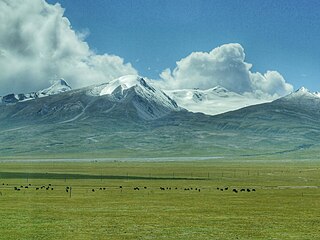
The Nyenchen Tanglha Mountains are a 700-kilometre (430 mi) long mountain range, and subrange of the Transhimalaya System, located in Tibet and the Tibet Autonomous Region of China.

The Bonaparte Indian Band a.k.a. Bonaparte First Nation, is a member band of the Shuswap Nation Tribal Council of the Secwepemc (Shuswap) people.

The Stswecem'c Xgat'tem First Nation, formerly known as Canoe Creek Band/Dog Creek Indian Band, created as a result of merger of the Canoe Creek Band and Dog Creek Band is a First Nations government of the Secwepemc (Shuswap) Nation, located in the Fraser Canyon-Cariboo region of the Central Interior of the Canadian province of British Columbia. It was created when the government of the then-Colony of British Columbia established an Indian reserve system in the 1860s. It is a member government of the Northern Shuswap Tribal Council.
The Lytton First Nation, a First Nations band government, has its headquarters at Lytton in the Fraser Canyon region of the Canadian province of British Columbia. While it is the largest of all Nlaka'pamux bands, unlike all other governments of the Nlaka'pamux (Thompson) people, it is not a member of any of the three Nlaka'pamux tribal councils, which are the Nicola Tribal Association, the Fraser Canyon Indian Administration and the Nlaka'pamux Nation Tribal Council.

San Mateo is an unincorporated community in Putnam County, Florida, United States, located just southeast of the city of Palatka. It is on the east shore of the St. Johns River between buoys 12 and 15; stretching from Buzzard Island to the entrance to Dunn's Creek. The main road through San Mateo is US Route 17, with a southern terminus of the overlap with Florida State Roads 20 and 100.

Vetrino Glacier is a 3.2 km long glacier on the northwest side of Imeon Range on Smith Island in the South Shetland Islands, Antarctica. It is situated northeast of Yablanitsa Glacier, southwest of Dalgopol Glacier and northwest of Ovech Glacier, drains the northwest slopes of Imeon Range north of Drinov Peak, northwest of Kostenets Saddle and west of Mount Pisgah, and flows northwestwards into Drake Passage both northeast and south of Gregory Point. The glacier is named after the town of Vetrino in northeastern Bulgaria.

The Rocky Mountain Foothills are an upland area flanking the eastern side of the Rocky Mountains, extending south from the Liard River into Alberta. Bordering the Interior Plains system, they are part of the Rocky Mountain System or Eastern System of the Western Cordillera of North America.
Yale First Nation is a First Nations government located at Yale, British Columbia. Yale has 16 distinct reserves stretching from near Sawmill Creek to American Creek, with the most southern reserve situated at Ruby Creek in the District of Kent.
Kitselas First Nation is the band government of the Kitselas subgroup of the Tsimshian. The band government is based at Gitaus in the Skeena Valley in the Skeena River valley to the northeast of the city of Terrace, British Columbia, Canada. Though there is no Tsimshian tribal council, they are a participant in the Tsimshian First Nations treaty council.

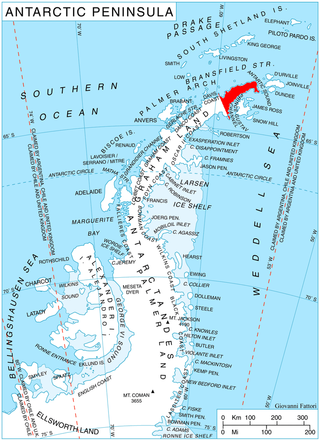
Sestrimo Glacier is the 11 km long and 4 km wide glacier on the northwest side of Trinity Peninsula in Graham Land on the Antarctic Peninsula. Situated southwest of Ogoya Glacier, west-northwest of Broad Valley and north of Cugnot Ice Piedmont. Draining the north slopes of Windy Gap, and flowing northwards east of Mount D'Urville and west of Argentino (Guerrero) Peak to enter Lafond Bay in Bransfield Strait south of Cockerell Peninsula.

Pashuk Glacier is the steep 2.7 km long and 600 m wide glacier on the southeast side of Imeon Range, Smith Island in the South Shetland Islands, Antarctica, which is draining southeastwards from Vakarel Saddle between the side ridges descending from Antim Peak and Evlogi Peak and separating it from Krivodol Glacier to the north and Rupite Glacier to the south respectively, and flows into Osmar Strait southwest of Sredets Point.

Vinson Plateau is the summit plateau of Vinson Massif, Sentinel Range in Ellsworth Mountains, Antarctica. It extends for 9 km between Goodge Col and Hammer Col linking it to the north-central part of Sentinel Range to the north-northwest and to Craddock Massif to the south-southeast respectively, and 4.5 km wide between Branscomb Peak and Silverstein Peak to the west and Schoening Peak and Marts Peak to the east. Elevation from 4000 m to 4600 m above sea level. Rising from the plateau is the summit of Antarctica Mount Vinson, and several other peaks higher than 4700 m, albeit of modest prominence: Clinch Peak, Corbet Peak, Silverstein Peak, Schoening Peak and Hollister Peak. The lower peaks of Fukushima and Opalchenie stand at the south extremity of the plateau. Its central part is drained by Roché Glacier and a tributary glacier in Jacobsen Valley, with both of them joining Branscomb Glacier.
Pōnui Nunatak is a nunatak located 0.6 nautical miles (1.1 km) southeast of Slattery Peak and 5.6 nautical miles (10.4 km) southwest of The Knoll in southeast Ross Island. The feature rises to 320 metres (1,050 ft) near the juncture of the island and the Ross Ice Shelf. The name Pōnui is one of several Māori-language wind names applied by the New Zealand Geographic Board in this vicinity.
Alyabiev Glacier is a glacier in Antarctica, flowing south from Gluck Peak into Boccherini Inlet and lies about 3 miles (5 km) West of Arensky Glacier on Beethoven Peninsula, Alexander Island, It was named by the USSR Academy of Sciences, in 1987, after Alexander Alyabiev (1787-1851), the Russian composer.

Mundraga Bay is the 28.6 km wide bay indenting for 23 km Nordenskjöld Coast in Graham Land, Antarctica. It is entered east of Fothergill Point and west of Cape Sobral. Local coastline is modified as a result of the Larsen A Ice Shelf disintegration and the subsequent retreat of the inflowing Darvari Glacier, Boryana Glacier, Desudava Glacier, Dinsmoor Glacier, Bombardier Glacier and Edgeworth Glacier in the 1990s and the early 21st century.

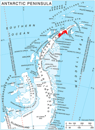
Aristotle Mountains is the fan-shaped sequence of ridges spreading east-northeastwards from its summit Madrid Dome on Oscar II Coast in Graham Land on the Antarctic Peninsula. The feature is named after the ancient Greek scientist Aristotle who in his book Meteorology dated c. 350 BC was the first to conjecture the existence of a landmass in the southern high-latitude region, calling it Antarctica.
Drifter Cirque is a cirque between Mount Schmidtman and Mount Naab at the northeast end of Eastwind Ridge in the Convoy Range of Victoria Land. Iceflow from Eastwind Ridge is insufficient to carry surficial moraine away into Fry Glacier and moraines lie in a tangled eddy. So named by the New Zealand Geographic Board which also considered the name Eddy Cirque.
Glazunov Glacier is a glacier flowing north into Stravinsky Inlet from Monteverdi Peninsula, Alexander Island. The glacier was named by the USSR Academy of Sciences in 1987 after Alexander Glazunov (1865-1936), a Russian composer.
Landy Ice Rises is a group of six ice rises in the Bach Ice Shelf near the head of Stravinsky Inlet, on Alexander Island. They were named by the UK Antarctic Place-names Committee in 1980 after Michael Paul Landy, a British Antarctic Survey glaciologist from 1975 to 1981, who worked in the area from Adelaide station, 1975–76, and Rothera station, 1976–77.
References
![]() This article incorporates public domain material from "Rachmaninoff Glacier". Geographic Names Information System . United States Geological Survey.
This article incorporates public domain material from "Rachmaninoff Glacier". Geographic Names Information System . United States Geological Survey.