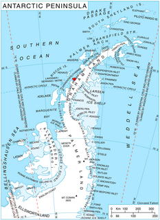
Northeast Glacier is a steep, heavily crevassed glacier on the west side of Hemimont Plateau, 21 km (13 mi) long and 8 km (5 mi) wide at its mouth, which flows from McLeod Hill westward and then south-westwards into Marguerite Bay between the Debenham Islands and Roman Four Promontory, on the west coast of Graham Land, Antarctica. Northeast Glacier was first surveyed in 1936 by the British Graham Land Expedition (BGLE) under John Riddoch Rymill. It was resurveyed in 1940 by members of the United States Antarctic Service (USAS), who first used the glacier as a sledging route, and so named by them because it lay on the north-eastern side of their base at Stonington Island.
Martin Glacier is a glacier, 3 nautical miles (6 km) wide and 9 nautical miles (17 km) long, which flows west and then northwest from the south side of Mount Lupa to the southeast corner of Rymill Bay where it joins Bertrand Ice Piedmont, on the west coast of Graham Land, Antarctica. It was first surveyed in 1936 by the British Graham Land Expedition (BGLE) under John Riddoch Rymill, and was resurveyed in 1948–1949 by the Falkland Islands Dependencies Survey. The glacier was named for James H. Martin, a member of the British Australian and New Zealand Antarctic Research Expedition (1929–1931) under Sir Douglas Mawson, and first mate of the Penola during the BGLE.

Gain Glacier is a large glacier on the east coast of Palmer Land, Antarctica, flowing northeast from Cat Ridge and entering the Weddell Sea between Imshaug Peninsula and Morency Island. It was mapped by the United States Geological Survey in 1974, and was named by the Advisory Committee on Antarctic Names for Louis Gain, a naturalist on the French Antarctic Expedition, 1908–10, and the author of several of the expedition reports on zoology and botany.
Prospect Glacier is a glacier between Kinnear Mountains and Mayer Hills, flowing north into Forster Ice Piedmont on the west coast of Antarctic Peninsula. It was first roughly surveyed in 1936 by the British Graham Land Expedition (BGLE) under Rymill. In 1954 the United Kingdom Antarctic Place-Names Committee (UK-APC) gave the name Prospect Pass to a col between Eureka Glacier and the glacier here described. During resurvey of the area by the Falkland Islands Dependencies Survey (FIDS) in 1958, the col was found to be an indeterminate feature, while this glacier is well marked and requires a name.

Birley Glacier is a glacier, at least 10 nautical miles (19 km) long, flowing west into the eastern extremity of Barilari Bay north of Vardun Point, on the west coast of Graham Land. First seen and roughly surveyed in 1909 by the French Antarctic Expedition under Jean-Baptiste Charcot, it was re-surveyed in 1935–36 by the British Graham Land Expedition (BGLE) under John Rymill, and later named for Kenneth P. Birley, who contributed toward the cost of the BGLE, 1934–37.

Cadman Glacier is a glacier, 1.5 nautical miles (3 km) wide at its mouth and about 7 nautical miles (13 km) long, flowing northwestward into the head of the southern arm of Beascochea Bay south of Plas Point on the west side of the Antarctic Peninsula.
Otlet Glacier is a glacier 9 nautical miles (17 km) long, flowing along the south side of Fontaine Heights to the west coast of Graham Land. Roughly charted by the British Graham Land Expedition (BGLE) under Rymill, 1934-37. More accurately mapped by the Falkland Islands Dependencies Survey (FIDS) from photos taken by Hunting Aerosurveys Ltd. in 1956-57. Named by the United Kingdom Antarctic Place-Names Committee (UK-APC) for Paul Otlet (1868–1944), Belgian documentalist, co-founder of the Institut International de Bibliographie at Brussels, 1895, and of the Universal Decimal Classification. He was a pioneer of the rational organization of polar information by an international classification scheme.
Comrie Glacier is a glacier 13 nautical miles (24 km) long, flowing west to enter the head of Bigo Bay on the west coast of Graham Land. It was first sighted and roughly surveyed by the French Antarctic Expedition in 1909. It was resurveyed in 1935–36 by the British Graham Land Expedition (BGLE), and later named for Leslie J. Comrie, founder and first Director of the Scientific Computing Service Ltd, London, who, as Superintendent of HM Nautical Almanac Office in 1934, greatly assisted the BGLE, 1934–37, by providing advance copies of The Nautical Almanac up to 1937.
Naess Glacier is a small glacier, which is separated from Chapman Glacier to the north by a rocky ridge, flowing from the west coast of Palmer Land into George VI Sound. First surveyed in 1936 by the British Graham Land Expedition (BGLE) under Rymill. Named by the United Kingdom Antarctic Place-Names Committee (UK-APC) in 1954 for Erling D. Naess, Mgr. of the Vestfold Whaling Co., who was of great assistance to the BGLE, 1934-37.
Neptune Glacier is a glacier on the east coast of Alexander Island, Antarctica, 12 nautical miles (22 km) long and 4 nautical miles (7 km) wide, flowing east into George VI Sound and the George VI Ice Shelf to the south of Triton Point. Although Neptune Glacier is not located within the mountain range Planet Heights, the glaciers name derives from the mountain range along with many other nearby glaciers named after planets of the Solar System. There are also other nearby landforms named in association with these glaciers. The glacier was first sighted from the air by Lincoln Ellsworth on November 23, 1935, and roughly mapped from photos obtained on that flight by W.L.G. Joerg. The mouth of the glacier was positioned in 1936 by the British Graham Land Expedition (BGLE). Named by the United Kingdom Antarctic Place-Names Committee (UK-APC) for the planet Neptune following a Falkland Islands Dependencies Survey (FIDS) survey in 1949. The head of the glacier was mapped from air photos taken by the Ronne Antarctic Research Expedition (RARE), 1947–48, by Searle of the FIDS in 1960.

Crume Glacier is a tributary glacier, 5 nautical miles (9 km) long, flowing east to enter Ommanney Glacier near the north coast of Victoria Land, Antarctica. The geographical feature was first mapped by the United States Geological Survey from surveys and from U.S. Navy air photos, 1960–63, and named by the Advisory Committee on Antarctic Names for William R. Crume, AS1, U.S. Navy, Support Equipment Maintenance Supervisor with Squadron VX-6 at McMurdo Station, Hut Point Peninsula, Ross Island, during Operation Deep Freeze 1968. The glacier lies situated on the Pennell Coast, a portion of Antarctica lying between Cape Williams and Cape Adare.
The Finley Heights are rugged coastal heights rising to 1,070 metres (3,510 ft) between the mouths of Bingham Glacier and Lurabee Glacier, on the east coast of Palmer Land, Antarctica. They were discovered by Sir Hubert Wilkins in an aerial flight on December 20, 1928. He considered the heights to be islands lying in a great transverse channel across the Antarctic Peninsula and named them "Finley Islands" for John H. Finley of The New York Times, who was then president of the American Geographical Society. Correlation of aerial photographs taken by Lincoln Ellsworth in 1935 and preliminary reports of the findings of the British Graham Land Expedition (BGLE), 1934–37, led W.L.G. Joerg to interpret this to be joined to the mainland. In published reports, members of the BGLE have concurred in this interpretation which was also borne out by the results of subsequent flights and a sledge trip from East Base, in 1940, by members of the United States Antarctic Service.
Fleming Glacier is a broad glacier 25 nautical miles (46 km) long on the west side of the Antarctic Peninsula, flowing west-northwest and terminating in Forster Ice Piedmont to the east of the Wordie Ice Shelf. The glacier was charted by the British Graham Land Expedition (BGLE) under John Rymill, 1934–37, and was photographed from the air by the United States Antarctic Service on September 29, 1940. This hitherto unnamed feature was named by the Advisory Committee on Antarctic Names in 1947 for Reverend W.L.S. Fleming, Dean of Trinity Hall, Cambridge University; also, chaplain, chief scientist, and geologist of the BGLE.

Gerry Glacier is a glacier on Edward VII Peninsula, Antarctica, flowing north between Reeves Peninsula and the Howard Heights to the head of Sulzberger Bay. Features in this area were photographed from the air and mapped by the Byrd Antarctic Expeditions, 1928–30 and 1933–35. This glacier was mapped by the United States Geological Survey from surveys and U.S. Navy air photos, 1959–65, and was named by the Advisory Committee on Antarctic Names for U.S. Senator Peter G. Gerry of Rhode Island, a long-time friend of the Byrd family and a contributor to the 1933–35 expedition.
Seller Glacier is a well-defined glacier, 20 nautical miles (37 km) long and 4 nautical miles (7 km) wide flowing westward into Forster Ice Piedmont, western Antarctic Peninsula, just north of Flinders Peak. Roughly surveyed by British Graham Land Expedition (BGLE), 1936–37, and resurveyed by Falkland Islands Dependencies Survey (FIDS) in December 1958.

Sohm Glacier is a glacier flowing into Bilgeri Glacier on Velingrad Peninsula, the west coast of Graham Land. Charted by the British Graham Land Expedition (BGLE) under Rymill, 1934-37. Named by the United Kingdom Antarctic Place-Names Committee (UK-APC) in 1959 for Victor Sohm, Austrian skiing exponent who invented a special type of ski skins and ski wax.

Somers Glacier is a glacier flowing northwest into Trooz Glacier on Kiev Peninsula, the west coast of Graham Land. First charted by the British Graham Land Expedition (BGLE) under Rymill, 1934-37. Named by the United Kingdom Antarctic Place-Names Committee (UK-APC) in 1959 for Henri Somers, chief engineer of the BelgAE's ship Belgica, which explored in the area in 1897-99.
Houston Glacier is a small glacier that drains north from Eielson Peninsula into Smith Inlet, on the east coast of Palmer Land, Antarctica. It was mapped by the United States Geological Survey in 1974, and named by the Advisory Committee on Antarctic Names for Robert B. Houston, U.S. Navy, a radioman at Palmer Station in 1973.

Lever Glacier is a glacier, 1.5 nautical miles (3 km) wide at its mouth and at least 6 nautical miles (11 km) long, flowing west-northwest, then west-southwest into the head of the northern arm of Beascochea Bay north of Chorul Peninsula, on the west coast of Graham Land, Antarctica. The glacier was first sighted and roughly surveyed in 1909 by the French Antarctic Expedition. It was resurveyed in 1935 by the British Graham Land Expedition (BGLE) under John Rymill, and named in 1954 for William Lever, 2nd Viscount Leverhulme, who contributed toward the cost of the BGLE.

Clarke Glacier is a 2-mile-wide, 20-mile-long glacier, located on the west coast of Graham Land in Antarctica. It flows west, along the north side of Sickle Mountain and the Baudin Peaksm, to Mikkelsen Bay.


