Red Lion, York County, Pennsylvania

Last updated
Red Lion
Borough
Red Lion, Pennsylvania.jpg
The former "Ma and Pa" railroad station in Red Lion
Red Lion, PA keystone marker.jpg
Keystone Marker
York County Pennsylvania incorporated and unincorporated areas Red Lion highlighted.svg
Location in York County and the state of Pennsylvania.
USA Pennsylvania location map.svg
Red pog.svg
Red Lion
Location of Red Lion in Pennsylvania
Usa edcp location map.svg
Red pog.svg
Red Lion
Red Lion (the United States)
Coordinates: 39°53′56″N76°36′23″W / 39.89889°N 76.60639°W / 39.89889; -76.60639 Coordinates: 39°53′56″N76°36′23″W / 39.89889°N 76.60639°W / 39.89889; -76.60639
Country United States
State Pennsylvania
County York
Settled1852
IncorporatedJanuary 16, 1880
Named for Red Lion Tavern
Government
   Mayor Walter Hughes
  Council PresidentTony Musso
Area
[1]
  Total1.31 sq mi (3.40 km2)
  Land1.31 sq mi (3.40 km2)
  Water0.00 sq mi (0.00 km2)
Elevation
921 ft (281 m)
Population
  Total6,373
  Estimate 
(2017) [2]
6,346
  Density4,833.21/sq mi (1,866.71/km2)
Time zone UTC-5 (EST)
  Summer (DST) UTC-4 (EDT)
ZIP code
17356
Area code(s) 717
FIPS code 42-63840
Website Official website

Red Lion is a borough in York County, Pennsylvania, settled in 1852 and incorporated on January 16, 1880. The population was 6,373 at the 2010 census.

York County, Pennsylvania County in the United States

York County is a county in the U.S. state of Pennsylvania. As of the 2010 census, the population was 434,972. Its county seat is York. The county was created on August 19, 1749, from part of Lancaster County and named either after the Duke of York, an early patron of the Penn family, or for the city and shire of York in England.

Pennsylvania State of the United States of America

Pennsylvania, officially the Commonwealth of Pennsylvania, is a state located in the northeastern, Great Lakes and Mid-Atlantic regions of the United States. The Appalachian Mountains run through its middle. The Commonwealth is bordered by Delaware to the southeast, Maryland to the south, West Virginia to the southwest, Ohio to the west, Lake Erie and the Canadian province of Ontario to the northwest, New York to the north, and New Jersey to the east.

Contents

History

Red Lion Tavern as it appeared in 1915 Red Lion Tavern 1915.jpg
Red Lion Tavern as it appeared in 1915

Red Lion, settled in 1852, was named after one of the first pubs in town, the Red Lion Tavern. [3]

Red Lion was a main stop along the old Maryland and Pennsylvania Railroad, known locally as the "Ma & Pa" Railroad. That railroad ran from York County to Baltimore, Maryland. [4]

Maryland and Pennsylvania Railroad

The Maryland and Pennsylvania Railroad, familiarly known as the "Ma and Pa", was an American short-line railroad between York and Hanover, Pennsylvania, formerly operating passenger and freight trains on its original line between York and Baltimore, Maryland, from 1901 until the 1950s. The Ma and Pa was popular with railfans in the 1930s and 1940s for its antique equipment and curving, picturesque right-of-way through the hills of rural Maryland and Pennsylvania. Reflecting its origin as the unintended product of the merger of two 19th-century narrow gauge railways, the meandering Ma and Pa line took 77.2 miles (124 km) to connect Baltimore and York, although the two cities are only 45 miles (72 km) apart in a straight line.

Red Lion was once famous for the many brands of cigars made in the town. The town produced millions of cigars per month, about 10% of the cigars made in the United States. [5] The town raises a cigar every New Year's Eve. [6]

Red Lion was also known nationwide for its furniture industry, with several large factories producing ornate, hand crafted furniture for over 100 years. The furniture industry has mostly shifted to kitchen cabinet production and retail store fixtures over the last 40 years. [7]

The Consumers Cigar Box Company and Red Lion Borough Historic District are listed on the National Register of Historic Places. [8]

Consumers Cigar Box Company

Consumers Cigar Box Company, also known as Red Lion Woodcraft Inc., is a historic factory located at Red Lion, York County, Pennsylvania. It was built in 1921, with additions in 1925 and 1935-1936. It is a large two-story, "L"-shaped building. It is built of concrete block and brick with a gable roof and stepped parapet. Cigar boxes were manufactured until the 1950s. The building housed various manufacturing operations until 1979.

Red Lion Borough Historic District

Red Lion Borough Historic District is a national historic district located at Red Lion Borough in York County, Pennsylvania. The district includes 1,482 contributing buildings, 1 contributing site, and 2 contributing structures in the central business district and surround residential areas of Red Lion. Most of the buildings are residential and primarily date between 1880 and 1935, and include notable examples of the Colonial Revival and Italianate styles. Notable non-residential buildings include the Red Lion Table Company building (1913), Red Lion Cabinet Company building (1917), C.H. Foreman cigar factory (1912), W.M. Gemmell & Company factory (1908-1912), Consolidated Tobacco Company (1915), E.A. Strobeck & Company factory, Roser Building (1876-1890), Odd Fellows Hall, Sheeler's General Store (1906), Bethany United Brethren Church (1928), Junior-Senior High School (1926), Hill School (1910-1912), U.S. Post Office (1934), and Maryland and Pennsylvania Railroad Station (1923). Located in the district and separately listed is the Consumers Cigar Box Company.

National Register of Historic Places federal list of historic sites in the United States

The National Register of Historic Places (NRHP) is the United States federal government's official list of districts, sites, buildings, structures, and objects deemed worthy of preservation for their historical significance. A property listed in the National Register, or located within a National Register Historic District, may qualify for tax incentives derived from the total value of expenses incurred preserving the property.

Geography

Red Lion is located about 35 miles (56.3 mi)southeast of Harrisburg. [9]

According to the United States Census Bureau, the borough has a total area of 1.3 square miles (3.3 km²), all of it land.

Demographics

Historical population
CensusPop.
1880 241
1890 524117.4%
1900 1,337155.2%
1910 2,09256.5%
1920 3,19852.9%
1930 4,75748.7%
1940 4,8912.8%
1950 5,1194.7%
1960 5,5949.3%
1970 5,6450.9%
1980 5,8243.2%
1990 6,1305.3%
2000 6,1490.3%
2010 6,3733.6%
Est. 20176,346 [2] −0.4%
Sources: [10] [11] [12]

As of the census [11] of 2000, there were 6,149 people, 2,575 households, and 1,645 families residing in the borough. The population density was 4,789.9 people per square mile (1,854.8/km²). There were 2,729 housing units at an average density of 2,125.8 per square mile (823.2/km²). The racial makeup of the borough was 97.12% White, 0.60% African American, 0.24% Native American, 0.41% Asian, 0.05% Pacific Islander, 0.33% from other races, and 1.25% from two or more races. Hispanic or Latino of any race were 0.91% of the population.

There were 2,575 households out of which 31.6% had children under the age of 18 living with them, 46.8% were married couples living together, 12.1% had a female householder with no husband present, and 36.1% were non-families. 29.6% of all households were made up of individuals and 11.0% had someone living alone who was 65 years of age or older. The average household size was 2.37 and the average family size was 2.92.

In the borough the population was spread out with 25.1% under the age of 18, 9.3% from 18 to 24, 32.2% from 25 to 44, 19.9% from 45 to 64, and 13.5% who were 65 years of age or older. The median age was 34 years. For every 100 females, there were 92.9 males. For every 100 females age 18 and over, there were 86.8 males.

The median income for a household in the borough was $35,828, and the median income for a family was $41,850. Males had a median income of $31,595 versus $21,934 for females. The per capita income for the borough was $17,723. About 6.1% of families and 10.4% of the population were below the poverty line, including 17.4% of those under age 18 and 11.1% of those age 65 or over.

Schools

On March 19, 2009 the Red Lion Area School Board voted 8-0 to close 2 elementary schools in the district. Chanceford and Edgar Moore elementary schools closed at the end of the 2009 school year. The students from the schools were placed in other schools throughout the district including a brand new elementary school. The new school, Larry J. Macaluso Elementary School, was completed in 2009 and is named after the Red Lion Area School District superintendent, who retired the same year.

School shooting

On April 24, 2003, at the Red Lion Junior High School in Red Lion, James Sheets killed the principal of the school, Eugene Segro, before killing himself. [9]

Local Venues

Former Opera House Opera House, Red Lion, YorkCo 1.jpg
Former Opera House

Red Lion, Pennsylvania has a rich musical heritage. It is the home of the Red Lion Felton band which was first started in 1932 as the Red Lion Concert Band and then later joined with the Felton Band in 1972. The band is composed of local musicians of all ages and performs at many community events. The Red Lion Area School District has also been awarded the NAMM Foundation’s “Best Community for Music Education” from 2012 to 2018 which considers the quality of programs and availability of music education within the schools and community.

Red Lion is also home to an extensive array of local underground bands and independent local artists, perhaps the most popular being Halestorm, who reached the top ten on the US Mainstream Rock charts and receives extensive local radio play.

Red Lion also had a fully functional opera house and a downtown movie theater until the mid-1960s. The opera house has since been converted to housing, and the movie theater was demolished and is now a parking lot.

Red Lion has many talented veteran and up and coming artists and musical talents of all genres (including funk, blues, jazz, bluegrass and country). The Guitar Spot USA and Tom's Music Trade are part of what's now known as a "Musician's Row" of sorts to local musicians and artists.

Red Lion Food

Red Lion supports 3 supermarkets, 32 restaurants including fast food, 3 beer stores and a state liquor store. There is also 2 Rutters and 1 Turkey Hill within borough limits.

The Red Lion Mile

In 2007 construction began on a one mile long walking trail beginning at the Red Lion Historical Society Train Station and ending at Springwood Road.[ citation needed ] The Red Lion Mile runs along the old Maryland and Pennsylvania railway line and is 90% complete.[ citation needed ] The Red Lion Mile committee hopes to have it completed in the near future.[ citation needed ] Private and public donations keep the project going.[ citation needed ] In August 2009, a benefit music festival featuring local bands was held near the completed portion of the trail.[ citation needed ]

Notable People

Lzzy Hale and Arejay Hale, members of the rock band, Halestorm.

Related Research Articles

New Holland, Pennsylvania Borough in Pennsylvania, United States

New Holland is a borough in Lancaster County, Pennsylvania, USA. As of the 2010 United States Census, the population was 5,378, up from 5,092 in the 2000 United States Census.

Lonaconing, Maryland Town in Maryland, United States

Lonaconing is a town in Allegany County, Maryland, along the Georges Creek Valley. It is part of the Cumberland, MD-WV Metropolitan Statistical Area. The population was 1,214 at the 2010 census.

Castle Shannon, Pennsylvania Borough in Pennsylvania, United States

Castle Shannon is a borough in Allegheny County, Pennsylvania, United States, and is part of the Pittsburgh Metro Area. The population was 8,316 at the 2010 census.

Birdsboro, Pennsylvania Borough in Pennsylvania, United States

Birdsboro is a borough in Berks County, Pennsylvania, United States. Located along the Schuylkill River, it is 8 miles (13 km) southeast of Reading. As of the 2010 census, it had a population of 5,163. In the past, Birdsboro was noted for its large foundries and machine shops, none of which remain in operation today.

Hamburg, Pennsylvania Borough in Pennsylvania, United States

Hamburg is a borough in Berks County, Pennsylvania, United States. The population was 4,289 at the 2010 census. The town is named after Hamburg, Germany.

Athens, Pennsylvania Borough in Pennsylvania, United States

Athens is a borough in Bradford County, Pennsylvania, United States, located 2 miles (3 km) south of the New York state line on the Susquehanna and Chemung rivers. The population was 3,749 in 1900 and 3,796 in 1910. The population was 3,367 at the 2010 census. Athens is in a small area locally known as "The Valley", a group of four contiguous communities in Pennsylvania and New York: Waverly, New York; South Waverly, Pennsylvania; Sayre, Pennsylvania; and Athens. The Valley has a population near 30,000.

Weatherly, Pennsylvania Borough in Pennsylvania, United States

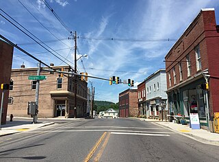
Weatherly is a borough in Carbon County, Pennsylvania, United States, located 12 miles (19 km) northwest of Jim Thorpe and 28 miles (45 km) south of Wilkes Barre. Early in the twentieth century, there were silk mills, foundries, a candy factory, a fabricating plant, and a cigar factory. In 1900 2,471 people lived there, and in 1910, the population was 2,501. The population was 2,525 at the 2010 census.

Oxford, Pennsylvania Borough in Pennsylvania, United States

Oxford is a borough in Chester County, Pennsylvania, United States. Oxford is the closest town to Lincoln University. The population was 5,574 at the 2017 census.

Benton, Columbia County, Pennsylvania Borough in Pennsylvania, United States

Benton is a borough in Columbia County, Pennsylvania, United States. The population was 824 at the 2010 census. It is part of the Bloomsburg–Berwick Micropolitan Statistical Area.

Middletown, Dauphin County, Pennsylvania Borough in Pennsylvania, United States

Middletown is a borough in Dauphin County, Pennsylvania, United States, on the Susquehanna River, 10 miles (16 km) southeast of Harrisburg. As of the 2010 census it had a population of 8,901. It is part of the Harrisburg–Carlisle Metropolitan Statistical Area.

Connellsville, Pennsylvania City in Pennsylvania, United States

Connellsville is a city in Fayette County, Pennsylvania, United States, 50 miles (80 km) southeast of Pittsburgh on the Youghiogheny River, a tributary of the Monongahela River. It is part of the Pittsburgh Metro Area. The population was 7,637 at the 2010 census, down from 9,146 at the 2000 census.

Mount Union, Pennsylvania Borough in Pennsylvania, United States

Mount Union is a borough in Huntingdon County, Pennsylvania, approximately 44 miles (71 km) southeast of Altoona and 12 miles (19 km) southeast of Huntingdon, on the Juniata River. In the vicinity are found bituminous coal, ganister rock, fire clay, and some timber. A major Easter grass factory is located in the northern quadrant of the borough limits; until May 2007, the facility was owned by Bleyer Industries. The population was 2,447 at the 2010 census.

Moscow, Pennsylvania Borough in Pennsylvania, United States

Moscow is a borough in Lackawanna County, Pennsylvania, United States. The population was 2,009 at the 2016 census. It is located approximately 9 miles from Scranton and 25 miles from Honesdale.

Stroudsburg, Pennsylvania Place in Pennsylvania, United States

Stroudsburg is a borough in Monroe County, Pennsylvania, United States. It is in the state's Poconos region, approximately five miles (8 km) from the Delaware Water Gap, at the confluence of the Brodhead, McMichaels and Pocono Creeks. It is in northeastern Pennsylvania. It is also the county seat of Monroe County. Stroudsburg is part of the East Stroudsburg, PA Metropolitan Statistical Area, which in turn is part of the New York combined statistical area. The population was 5,567 at the 2010 census.

Schwenksville, Pennsylvania Borough in Pennsylvania, United States

Schwenksville is a borough in Montgomery County, Pennsylvania, United States. The population was 1,385 at the 2010 census. It is notable for being located near the site of the Philadelphia Folk Festival. The borough was founded in 1684, when the Lenni-Lenape Indians ceded to William Penn the land along the Perkiomen Creek; it was incorporated in 1903. The borough was named for George Schwenk, whose son, Jacob Schwenk, served in George Washington's army.

Mansfield, Pennsylvania Borough in Pennsylvania, United States

Mansfield is a borough located in east-central Tioga County, Pennsylvania, United States, in the Tioga River valley. It is situated at the intersection of U.S. Route 6 and U.S. Business Route 15, about 36 miles (58 km) southwest of Elmira, New York.

Delta, Pennsylvania Borough in Pennsylvania, United States

Delta is a borough in York County, Pennsylvania, United States, and one of the southernmost communities in Pennsylvania. The population was 728 at the 2010 census. It is served by the South Eastern School District which provides a public education.

Railroad, Pennsylvania Borough in Pennsylvania, United States

Railroad is a borough in York County, Pennsylvania, United States. The population was 278 at the 2010 census.

Seven Valleys, Pennsylvania Borough in Pennsylvania, United States

Seven Valleys is a borough in York County, Pennsylvania, United States. The population was 517 at the 2010 census.

Stewartstown, Pennsylvania Borough in Pennsylvania, United States

Stewartstown is a borough in York County, Pennsylvania, United States. The population was 2,089 at the 2010 census.

References

  1. "2017 U.S. Gazetteer Files". United States Census Bureau. Retrieved Mar 24, 2019.
  2. 1 2 "Population and Housing Unit Estimates" . Retrieved March 24, 2018.
  3. "History of Red Lion Borough". Red Lion, Pennsylvania. Retrieved 31 August 2015.
  4. "About the Maryland and Pennsylvania Railroad". THE MARYLAND AND PENNSYLVANIA RAILROAD HISTORICAL SOCIETY. Retrieved 31 August 2015.
  5. Kauffman, Christina (25 May 2011). "Last Red Lion cigar factory closes for good". York Dispatch . Retrieved 31 August 2015.
  6. Randall, Laura (2008). Eastern Pennsylvania: An Explorer's Guide. Woodstock, Vermont: The Countrymen Press. p. 201. ISBN   9780881507478.
  7. "National Historic Landmarks & National Register of Historic Places in Pennsylvania" (Searchable database). CRGIS: Cultural Resources Geographic Information System.Note: This includes Elizabeth L. Roman (February 2000). "National Register of Historic Places Inventory Nomination Form: Red Lion Borough Historic District" (PDF). Retrieved 2011-12-28.
  8. National Park Service (2010-07-09). "National Register Information System". National Register of Historic Places . National Park Service.
  9. 1 2 CNN: Red Lion Area Junior High School Shooting
  10. "Census of Population and Housing". U.S. Census Bureau. Retrieved 11 December 2013.
  11. 1 2 "American FactFinder". United States Census Bureau . Retrieved 2008-01-31.
  12. "Incorporated Places and Minor Civil Divisions Datasets: Subcounty Resident Population Estimates: April 1, 2010 to July 1, 2012". Population Estimates. U.S. Census Bureau. Archived from the original on 17 June 2013. Retrieved 11 December 2013.