
Liberty is a town in Sullivan County, New York, United States. The population was 9,885 at the 2010 census. The town contains a village also named Liberty. The village is bisected by New York State Route 52 (NY 52) and NY 55, and is crossed by NY 17.

Northwest is the northwestern quadrant of Washington, D.C., the capital of the United States, and is located north of the National Mall and west of North Capitol Street. It is the largest of the four quadrants of the city, and it includes the central business district, the Federal Triangle, and the museums along the northern side of the National Mall, as well as many of the District's historic neighborhoods.

Northwest Philadelphia is a section of the city of Philadelphia, Pennsylvania. The official boundary is Stenton Avenue to the north, the Schuylkill River to the southwest, Northwestern Avenue to the northwest, Roosevelt Boulevard to the south, and Wister Street and Stenton Avenue to the east. The area is divided by Wissahickon Creek into two subsections, Upper Northwest and Lower Northwest Philadelphia. Upper Northwest are Germantown, Mount Airy, and Chestnut Hill, and Lower Northwest are Roxborough, Wissahickon, East Falls, and Manayunk. The area of Philadelphia west of the Schuylkill River is known as West Philadelphia. The Philadelphia Police Department patrols two districts located within Northwest Philadelphia. The two patrol districts serving Northwest Philadelphia are the 5th and 14th districts.

Worsley is a hamlet in northern Alberta, Canada within Clear Hills County. It is located in the Peace Country, at the northern end of Highway 726, approximately 18 km (11 mi) north of Highway 64, 59 km (37 mi) northwest of Hines Creek and 50 km (31 mi) east of the British Columbia border. It lies at an elevation of 650 m (2,130 ft) amidst prairie farmland and ranchland.

Northwest Hills, sometimes referred to as Far West after its main street, is a suburb in the northwestern part of Austin, Texas, United States. The neighborhood is home to the largest concentration of Jewish residents in Austin, and includes a 40-acre complex housing a number of Jewish community organizations, synagogues, and schools.

Swallow Hill is an unincorporated community in New Castle County, Delaware, United States. Swallow Hill is located northwest of the intersection of Delaware Route 82 and Pyles Ford Road to the northwest of Wilmington.
Northern Lights is the self-titled debut album by the progressive bluegrass band Northern Lights, recorded in 1976 under the Revonah Records label.
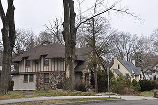
The Revonah Manor Historic District is a 23.1-acre (9.3 ha) predominantly residential historic district in Stamford, Connecticut that was listed on the National Register of Historic Places in 1986. The district encompasses what was one of Stamford's first planned residential developments, developed by Herman Henneberg and his son-in-law Henry Jevne, with many houses designed by Lawrence Barnard. The result was a remarkable concentration of fairly uniformly-designed Colonial Revival and Tudor Revival houses in a three-block area. Most of the houses are on Urban, Chester, and Fifth Streets, between Revonah Avenue and Bedford Street.

Horse Hill is a residential area in the northeast portion of the City of Edmonton in Alberta, Canada. It was formally established on May 22, 2013 through Edmonton City Council's adoption of the Horse Hill Area Structure Plan, which guides the overall development of the area. The area is estimated to have a population of 71,467 at full build-out of five neighbourhoods.

Rum Hill is a mountain located in Central New York Region of New York northwest of the Hamlet of Pierstown. Red House Hill is located southeast, Metcalf Hill is located south, Allen Lake and Mohegan Hill are located north-northwest and Otsego Lake is located east of Rum Hill.

Whalen Hill is a mountain located in Central New York region of New York northwest of Hartwick, New York. It is named after D. Whalen, a local land owner in 1868.
Dutch Hill is a small mountain chain located in Central New York region of New York northwest of Portlandville, New York. It consists of two peaks the highest being 1699 feet.
Badeau Hill is a mountain located in Central New York region of New York northwest of Elk Creek, New York.
Stone Quarry Hill is a mountain in the Central New York region of New York. It is located northwest of East Worcester, New York.
Wooley Hill is a mountain in the Central New York Region of New York state, USA. It is located northwest of Garrattsville. Gross Hill is located southwest of Wooley Hill.
Gross Hill is a mountain in the Central New York Region of New York. It is located northwest of Garrattsville, New York. Crystal Lake is located south and Wooley Hill is located northeast of Gross Hill.
Sisson Hill is a mountain in the Central New York region of New York. It is located northwest of Unadilla, New York.
Kilkenny Hill is a mountain in the Central New York region of New York, USA. It is located northwest of Unadilla, New York. Kilkenny Hill is part of the Northern Allegheny Plateau Ecoregion.
Chuck Hill is a mountain in Sullivan County, New York. It is located west-southwest of Liberty. Walnut Mountain is located southeast and Revonah Hill is located north-northeast of Chuck Hill.

Cerro del Diablo is a mountain in the municipality of Ponce, Puerto Rico, located north-northwest of the city of Ponce. The 2234-foot high hill sits at the foothills of the Cordillera Central and is located in Barrio Tibes.

