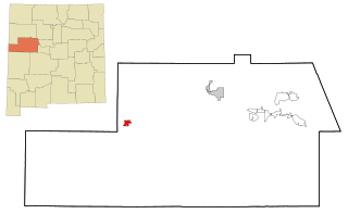
Pinehill or Pine Hill is a census-designated place in Cibola County, New Mexico, United States. It is located on the Ramah Navajo Indian Reservation. The population was 88 at the 2010 census. The location of the CDP in 2010 had become the location of the Mountain View CDP as of the 2020 census, while a new CDP named "Pinehill" was listed 8 miles (13 km) further south, at a point 4 miles (6 km) southeast of Candy Kitchen.

Mission Hills is a neighborhood in Los Angeles, California, located in the San Fernando Valley.
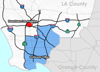
The Gateway Cities region, or Southeast Los Angeles County, is an urbanized region located in southeastern Los Angeles County, California, between the City of Los Angeles proper, Orange County, and the Pacific Ocean. The cluster of cities has been termed "Gateway Cities" in that they serve as a "gateway" between the LA and Orange counties, with the city of Cerritos equidistant from Downtown L.A., Long Beach, and Santa Ana in Orange County. As such, the area is central to the Los Angeles-Long Beach-Anaheim, CA Metropolitan Statistical Area (MSA), and has a population of approximately 2,000,000 residents.

The Southeastern United States, also known as the American Southeast or simply the Southeast, is a geographical region of the United States located in the eastern portion of the Southern United States and the southern portion of the Eastern United States. The region includes a core of states that reaches north to Maryland and West Virginia, bordering the Ohio River and Mason–Dixon line, and stretches west to Arkansas and Louisiana.

Timms Hill or Timm's Hill is the highest natural point in the U.S. state of Wisconsin and is located in north-central Wisconsin in Timms Hill County Park in the Town of Hill in Price County. After being surveyed by Quentin Stevens of Ogema Telephone Co in 1962, Timms Hill was discovered to have an elevation of 1,951.5 ft (595 m). It is less than 1 mile (1.6 km) south of Highway 86, about midway between Ogema and Spirit and about 23 miles (37 km) west of Tomahawk.

Shirase Glacier is a large glacier entering Havsbotn, the bay that forms the head of Lutzow-Holm Bay in Antarctica. The area occupied by this feature was first mapped as a bay and named Instefjorden by the Lars Christensen Expedition (LCE) of 1936–37. Surveys by Japanese Antarctic Research Expedition (JARE) of 1957–62, revealed the large glacier in this position which they named after Lt. Nobu Shirase, leader of the Japanese Antarctic Expedition of 1911–12. Its nearby features were also charted and named by JARE unless otherwise noted.
Four Corners is a place in Weston County, Wyoming, United States. It is located in northeastern Wyoming near the Bear Lodge Mountains, part of the Black Hills, at the intersection of U.S. Route 85 and Wyoming Highway 585. It is located north of Newcastle, southeast of Sundance, Wyoming, and southwest of Lead, South Dakota. Originally a stage station on the famous stagecoach road Cheyenne Black Hills Stage Route connecting Cheyenne and the Union Pacific Railroad with the gold fields of Deadwood, it is today the site of a small store, bed-and-breakfast ranches, vacation homes, and tourist camps.
Bean's Grant is a township in southern Coös County, New Hampshire, United States, north of Crawford Notch State Park. The grant lies entirely within the White Mountain National Forest. The population was zero as of the 2020 census.

Fort Howard was a 19th-century fortification in the north central United States, built by the U.S. Army. It was located along the west bank of the Fox River in Green Bay, Wisconsin.

Grant Township is a township in Jackson County, Kansas, USA. As of the 2000 census, its population was 212. The southeasternmost part of the township is located within the Prairie Band Potawatomi Indian Reservation.
Maverick Junction, South Dakota, United States, is an unincorporated community and census-designated place (CDP) located in Fall River County at the intersection of South Dakota Highway 79 and US Highways 18 and 385, approximately five miles southeast of Hot Springs. The population was 46 at the 2020 census.

Russell Township is a township in Russell County, Kansas, United States. As of the 2010 United States Census, it had a population of 82.

Grant Township is a township in Russell County, Kansas, United States. As of the 2010 United States Census, it had a population of 186.
Rock Hill is an unincorporated community and census-designated place (CDP) in Grant Parish, Louisiana, United States. As of the 2010 census it had a population of 274.

Rum Hill is a mountain located in Central New York Region of New York northwest of the Hamlet of Pierstown. Red House Hill is located southeast, Metcalf Hill is located south, Allen Lake and Mohegan Hill are located north-northwest and Otsego Lake is located east of Rum Hill.
Red House Hill is a mountain in the Central New York Region of the State of New York, United States. It is located south-southwest of the Hamlet of Springfield Center, New York, west of Hutter Point and Six Mile Point of Otsego Lake, and southeast of Rum Hill. Mohican Brook flows eastward along the southern edge of the hill.
Dairy Hill is a 1,844-foot-tall (562 m) summit located in Central New York Region of New York located in the Town of Norway in Herkimer County, southeast of Norway. The mountain is the former location of a 79-foot-6-inch-tall (24.23 m) steel fire lookout tower.

Hills Prairie, or Hill's Prairie, is an unincorporated community in Bastrop County, Texas, United States. According to the Handbook of Texas, the community had a population of 50 in 2000. It is located within the Greater Austin metropolitan area.
Leonard Hill is a 2,592-foot-tall (790 m) mountain in Schoharie County, New York. It is located east-southeast of North Blenheim. Safford Hill is located northwest and Hubbard Hill is located southeast of Leonard Hill. In 1948, the Conservation Commission built an 80-foot-tall (24 m) steel fire lookout tower on the mountain. The tower ceased fire watching operations at the end of the 1988 season and was officially closed in early 1989. The tower remains on the summit, but is closed to the public. A local group is planning to restore the tower and reopen it to the public.
Washburn Mountain is a 1,496-foot-tall (456 m) mountain in New York. It is located south-southeast Copake Falls in Columbia County. From 1932 to 1964, the mountain was the location of a 60-foot-tall (18 m) steel fire lookout tower now located on Beebe Hill. Alander Mountain is located southeast of Washburn Mountain.

