Kanad is a town and a nagar parishad in Agar Malwa district in the Indian state of Madhya Pradesh. It comes under Kanad Parishad. It belongs to Ujjain Division. It is situated along the Agar–Sarangpur SH-41 highway. It is located 18 km (11 mi) towards east from the district headquarters of Agar Malwa, 83 km (52 mi) from Ujjain, 186 km (116 mi) from the state capital of Bhopal.

Eid prayers, also referred to as Salat al-Eid, are holy holiday prayers in the Islamic tradition. The literal translation of the word "Eid" in Arabic is "festival" or "feast" and is a time when Muslims congregate with family and the larger Muslim community to celebrate.
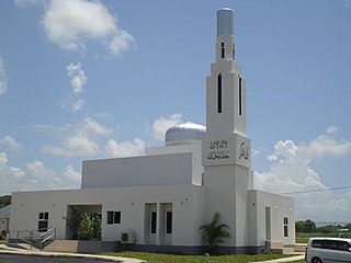
Jamaica is a predominantly Christian country, with Islam being a minority religion. Due to the secular nature of Jamaica's constitution, Muslims are free to proselytize and build places of worship in the country.

Jugsalai is a township and business center adjacent to Tatanagar Railway Station, Jamshedpur and a municipality in the Dhalbhum subdivision of the Purbi Singhbhum district in the Indian state of Jharkhand. It is often referred as a wholesale market of Jamshedpur.
Labbaikudikadu is a town located in the northeastern part of Perambalur district of the Indian state of Tamil Nadu. It is classified as an urban area. and governed locally by a panchayat.
Lalpet is a Panchayat town in Cuddalore district, Tamil Nadu. Lalpet is situated in lush green surrounding with water bodies. Lalpet was named after Lal Khan who held an administrative position under the ruling Prince Nawab of Arcot. Under the command of the prince, Lal Khan developed this town in 1775 for Arab traders, Muslims, international visitors and people of other faiths to dwell together peacefully. Arabic college named "Jamia Manba'ul Anwar" was established here in 1862. Lalpet was established before in 1775 by Lal Khan. Lalpet is a commune. Lalpet Commune consists of one census town and 8 panchayat villages. The town extends over an area of 16.425 km2.
Manglaur Riyasat is a town with municipal board in Haridwar district in the Indian state of Uttarakhand. Pin code of Manglaur is 247656. Manglaur is located on national highway-58 (Delhi–Haridwar). It is 175 km away from Delhi and about 10 km from Roorkee.
Mhowgaon is a Nagar Panchayat under Sub Division Dr. Ambedkar Nagar (Mhow) in Indore district in the Indian state of Madhya Pradesh. The total geographical area of Mhowgaon nagar panchayat is 13.5 km2 and it is the smallest city by area in the sub district. The population density of the city is 2309 persons per km2. Mhowgaon is divided into 15 wards for which elections are held every 5 years. Among them, Mhowgaon Ward No. 2 is the most populous ward with a population of 3440 and Mhowgaon Ward No. 15 is the least populous ward with a population of 957. Mhowgaon Nagar Panchayat has total administration over 6,373 houses to which it supplies basic amenities like water and sewerage. It is also authorized to build roads within Nagar Panchayat limits and impose taxes on properties coming under its jurisdiction.
Saurikh is a nagar panchayat in Kannauj district in the Indian state of Uttar Pradesh. Its old name was Sau-Rishi.It is located near main industrial and educational hub of Dibiyapur which is around at a distance of 55 km from the town.
Shamsabad is a town and a nagar panchayat in Farrukhabad district in the Indian state of Uttar Pradesh.
Vallam is a panchayat town in the Thanjavur taluk of Thanjavur district in the Indian state of Tamil Nadu.
Bahadurganj is a Municipality located of Zahurabad pargama of the Kasimabad Tehsil in Ghazipur district of Uttar Pradesh, India. Bahadurganj is located one the banks of Tamsa and Bhainsahi rivers.
Antri is a village in Madhya Pradesh, India, lying 25 km (16 mi) south of Gwalior. Kirar thakur and brahmans and other caste kamariya, baghel, gurjar, kachi etc. Lives in antri. village is famous for clay deposits. Current chairman Smt. Sunita sunil sharma (BJP)
Nashirabad is a small town in Jalgaon district in the northern Maharashtra state in India. It was named after Nasiruddin Badshah. The earlier name of the town was Solnimbhore. This was due to fact that the town had 16 Hanuman temples and 16 main doors.

Gauriganj is a city, municipal corporation, tehsil and administrative headquarters of Amethi district in Ayodhya division, Uttar Pradesh, India. It is situated about 126 km from the state capital Lucknow. Before July 2010, it was part of Sultanpur district. After that Gauriganj, Amethi, Jais, Jagdispur and Salon formed a new district Chhatrapati Sahuji Maharaj Nagar, later named Gauriganj and now Amethi. Gauriganj is connected with State Highway 34 and National Highway 128.
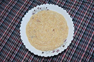
Both festivals of Eid celebrated in the Muslim world include cuisines specific to countries and localities.
Pernambut is a town and village headquarters also a Municipality in Vellore district in the Indian state of Tamil Nadu. The economy is dependent on leather tanning industry, earning it the nickname Leather Tanning city of Tamil Nadu. Pernambut is a municipality and headquarters of Pernambut Taluk which is an administrative division comprising 52 Revenue villages in the district of Vellore.
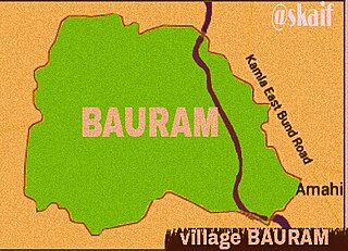
Bauram is a large village located in Darbhanga, Bihar, India. It is situated about 60 km east of the district headquarters and 10 km east of the sub-divisional headquarters. The area of Bauram is about 2400 bighas.
Manik Chowk is a village in the Indian state of Bihar.
Pokhraira is a village in Bokhra block of Sitamarhi District in Bihar state of India. It is surrounded by three main cities of Bihar, which are Muzaffarpur, Darbhanga and Sitamarhi. Pokhraira is 27 km distance from district main city Sitamarhi and 97 km distance from state capital Patna.
