Sayers, Texas

Last updated

Sayers, Texas
USA Texas location map.svg
Red pog.svg
Sayers
Usa edcp location map.svg
Red pog.svg
Sayers
Coordinates: 29°22′27″N98°17′20″W / 29.37417°N 98.28889°W / 29.37417; -98.28889
Country United States
State Texas
County Bexar
Elevation
[1]
528 ft (161 m)
Time zone UTC-6 (Central (CST))
  Summer (DST) UTC-5 (CDT)
ZIP code
78101
Area code 210
GNIS feature ID1376028 [1]

Sayers is a small unincorporated community in Bexar County, Texas, United States. [1] It is part of the San Antonio Metropolitan Statistical Area.

Contents

History

Sayers was established after the Civil War. A post office was established in Sayers in 1885. Fifty people were living in Sayers in 1896, while there were two general stores and a church. The Adkins post office was moved to Sayers, and the postal area was named Adkins. It lost half of its population in 1940 and had three businesses, which all closed after World War II. [2] The community now has several churches, restaurants, a small grocery store, a gas station, and a cemetery. [3]

Geography

Sayers is located at the intersection of U.S. Route 87 and FM 1628, 13 mi (21 km) southeast of Downtown San Antonio in eastern Bexar County. [2]

Education

Sayers had its own school in 1896. [2] Today, the community is served by the East Central Independent School District. Salem-Sayers Baptist School also serves the community.

The film Sugarland Express, which is based on the true story of Sayers residents, was filmed in and around Sayers.

Related Research Articles

<span class="mw-page-title-main">San Antonio</span> City in Texas, United States

San Antonio, officially the City of San Antonio, is a city in and the county seat of Bexar County, Texas, United States. The city is the seventh-most populous in the United States, the second-largest in the Southern United States, and the second-most populous in Texas after Houston. San Antonio is the largest city of the San Antonio–New Braunfels metropolitan statistical area. Commonly called Greater San Antonio, the metropolitan area had a population of 2,601,788 based on the 2020 U.S. census estimates, making it the 24th-largest metropolitan area in the United States and third-largest in Texas.

<span class="mw-page-title-main">Kendall County, Texas</span> County in Texas, United States

Kendall County is a county located on the Edwards Plateau in the U.S. state of Texas. In 2020 census, its population was 44,279. Its county seat is Boerne. The county is named for George Wilkins Kendall, a journalist and Mexican–American War correspondent.

<span class="mw-page-title-main">Guadalupe County, Texas</span> County in Texas, United States

Guadalupe County is a county located in the U.S. state of Texas. As of the 2020 census, its population was 172,706. The county seat is Seguin. The county was founded in 1846 and is named after Guadalupe River.

<span class="mw-page-title-main">Bexar County, Texas</span> County in Texas, United States

Bexar County is a county in the U.S. state of Texas. It is in South Texas and its county seat is San Antonio.

<span class="mw-page-title-main">Atascosa County, Texas</span> County in Texas, United States

Atascosa County is a county located in the U.S. state of Texas. It is in South Texas and its county seat is Jourdanton.

<span class="mw-page-title-main">Converse, Texas</span> City in Texas, United States

Converse is a city in Bexar County, Texas, United States, 15 miles (24 km) northeast of downtown San Antonio. As of the 2020 census, it had a population of 27,466. It is part of the San Antonio Metropolitan Statistical Area.
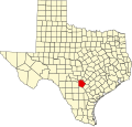
<span class="mw-page-title-main">Lytle, Texas</span> City in Atascosa, Bexar, and Medina counties in Texas, U.S.

Lytle is a city in Atascosa, Bexar, and Medina counties in the U.S. state of Texas. The population was 2,492 at the 2010 census. It is part of the San Antonio Metropolitan Statistical Area.

<span class="mw-page-title-main">Schertz, Texas</span> City in Texas, United States

Schertz is a city in Guadalupe, Bexar, and Comal counties in the U.S. state of Texas, within the San Antonio–New Braunfels metropolitan area. The population was 42,002 at the 2020 census, up from 31,465 at the 2010 census. Schertz was settled by Alsatian emigrants in the 1800s.

Von Ormy is a city in southwest Bexar County, Texas, United States. As of the 2020 census, it had a population of 1,174. It is part of the San Antonio metropolitan statistical area.

Pipe Creek is an unincorporated community in Bandera County, Texas, United States. According to the Handbook of Texas, it had a population of approximately 66 in 1990. It is part of the San Antonio Metropolitan Statistical Area.

Adkins is an unincorporated community located partly in eastern Bexar County, Texas, United States. It is located within the Greater San Antonio metropolitan area.

<span class="mw-page-title-main">Greater San Antonio</span> Metropolitan area in Texas, United States

Greater San Antonio, officially designated San Antonio–New Braunfels, is an eight-county metropolitan area in the U.S. state of Texas defined by the Office of Management and Budget (OMB). The metropolitan area straddles South Texas and Central Texas and is on the southwestern corner of the Texas Triangle. The official 2020 U.S. census showed the metropolitan area's population at 2,558,143—up from a reported 1,711,103 in 2000—making it the 24th largest metropolitan area in the United States. Austin–Round Rock lies about 80 mi (130 km) northeast of Greater San Antonio.

Atascosa is an unincorporated community located in southwestern Bexar County, Texas, United States. According to the Handbook of Texas, the community had a population of 300 in 2000. The community is part of the San Antonio Metropolitan Statistical Area.

<span class="mw-page-title-main">Leon Springs, Texas</span> Unincorporated community in Texas, United States

Leon Springs is an unincorporated community in Bexar County, Texas, United States, now partially within the city limits of San Antonio. According to the Handbook of Texas, the community had a population of 137 in 2000. It is located within the San Antonio Metropolitan Area.

Losoya is an unincorporated community in Bexar County, Texas, United States. According to the Handbook of Texas, the community had a population of 322 in 2000. It is a part of the San Antonio–New Braunfels metropolitan area.

Leal is a ghost town in Atascosa and Bexar counties, in the U.S. state of Texas. It is located within the San Antonio metropolitan area.

Bexar is an unincorporated community in Bexar County, in the U.S. state of Texas. It is located within the Greater San Antonio metropolitan area.

Cassin is an unincorporated community in Bexar County, in the U.S. state of Texas. According to the Handbook of Texas, the community had a population of 50 in 1990. It is located within the Greater San Antonio metropolitan area.

Southon is an unincorporated community in Bexar County, in the U.S. state of Texas. According to the Handbook of Texas, the community had a population of 113 in 2000. It is located within the Greater San Antonio metropolitan area.

Thelma is an unincorporated community in Bexar County, in the U.S. state of Texas. According to the Handbook of Texas, the community had a population of 45 in 2000. It is located within the Greater San Antonio metropolitan area.

References

  1. 1 2 3 U.S. Geological Survey Geographic Names Information System: Sayers, Texas
  2. 1 2 3 Long, Christopher. "Sayers, TX". tshaonline.org. Retrieved August 9, 2022.
  3. "Sayers, Texas". Texas Escapes Online Magazine. Retrieved August 9, 2022.