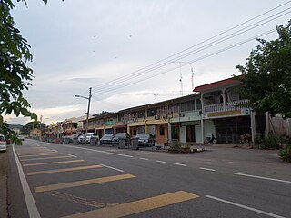
Sengkang, Kulai

Last updated

Sengkang is a town in Ledang District, Johor, Malaysia. It located in the east of Ledang Town. The local authority of town is Ledang Municipal Council. [1] [2]

Johor State of Malaysia

Johor, formerly known as Johore, is a state of Malaysia in the south of the Malay Peninsula. Johor has land borders with the Malaysian states of Pahang to the north and Malacca and Negeri Sembilan to the northwest. Johor shares maritime borders with Singapore to the south and Indonesia to both the west and east. Johor Bahru is the capital city and the economic centre of the state, Kota Iskandar is the seat of the state government, and Muar serves as the royal town of the state. The old state capital is Johor Lama. As of the 2015 census, the state's population is 3,553,600. Johor has highly diverse tropical rainforests and an equatorial climate. The state's mountain ranges form part of the Titiwangsa Range, which is part of the larger Tenasserim Range connected to Thailand and Myanmar, with Mount Ophir being the highest point in Johor.

Malaysia Federal constitutional monarchy in Southeast Asia

Malaysia is a country in Southeast Asia. The federal constitutional monarchy consists of 13 states and three federal territories, separated by the South China Sea into two similarly sized regions, Peninsular Malaysia and East Malaysia. Peninsular Malaysia shares a land and maritime border with Thailand in the north and maritime borders with Singapore in the south, Vietnam in the northeast, and Indonesia in the west. East Malaysia shares land and maritime borders with Brunei and Indonesia and a maritime border with the Philippines and Vietnam. Kuala Lumpur is the national capital and largest city while Putrajaya is the seat of federal government. With a population of over 30 million, Malaysia is the world's 44th most populous country. The southernmost point of continental Eurasia, Tanjung Piai, is in Malaysia. In the tropics, Malaysia is one of 17 megadiverse countries, with large numbers of endemic species.

Related Research Articles

Gemas Place in Negeri Sembilan, Malaysia

Gemas is a small town in Tampin District, Negeri Sembilan, Malaysia, near the Negeri Sembilan-Johor state border.

Jementah Mukim in Johor, Malaysia

Jementah is a mukim in Segamat District, Johor, Malaysia.

Tangkak Town in Johor, Malaysia

Tangkak is the principal town and capital of Tangkak District in Johor, Malaysia. The town is nicknamed "Fabric Town" or "Syurga Kain" in honour of its many textile shops. It is also well known as being a major entry point to Mount Ophir, the highest mountain in Johor.

Bukit Kepong Mukim in Johor, Malaysia

Bukit Kepong is a mukim in Muar District, Johor, Malaysia. It is located near the Muar River.

Dengkil human settlement in Malaysia

Dengkil is a mukim in Sepang District, Selangor, Malaysia.

Sagil human settlement in Malaysia

Sagil is a small town in Tangkak District, Johor, Malaysia. Sagil is near the border of Johor with Malacca. Air Panas Water Fall is located here, and to access to the peak of Gunung Ledang. Gunung Ledang is around 5 minute drive distance from Sagil town.

Sungai Mati is a small town in Serom, Tangkak District, Johor, Malaysia.

Sungai Udang human settlement in Malaysia

Sungai Udang is a mukim in Central Malacca, Malacca, Malaysia. It is situated within the parliamentary constituency of Tangga Batu. It have another name call which is "Home of Commander".

Lendu is a small town in Melaka, Malaysia. Lendu is situated within the parliamentary constituency of Masjid Tanah.

Johol is a town, a mukim and a state assembly constituency in Kuala Pilah District, Negeri Sembilan, Malaysia. It is roughly halfway between Tampin and Kuala Pilah, along Highway .

Rapovce municipality of Slovakia

Rapovce is a village and municipality in the Lučenec District in the Banská Bystrica Region of Slovakia.

Plaveč, Stará Ľubovňa District municipality of Slovakia

Plaveč is a village and municipality in Stará Ľubovňa District in the Prešov Region of northern Slovakia.

Muar District District of Malaysia in Johor

The Muar District is a district in Johor, Malaysia. Muar is located at the mouth of the Muar River, on the coast of the Straits of Malacca. The Muar District covers 1,354 km2, with a population of 233,779 (2010).

Kesang, Malaysia

Kesang is a mukim in Tangkak District, Johor, Malaysia.

Parit Bunga

Parit Bunga is a small town in Tangkak District, Johor, Malaysia. It is located on the Muar River and on the intersection between the roads to Malacca and Tangkak.

Simpang Pertang

Simpang Pertang is a small town in Jelebu District, Negeri Sembilan, Malaysia.

Mekla is a town and commune in Tizi Ouzou Province in northern Algeria.

Tenang Stesen human settlement in Malaysia

Tenang Stesen, commonly known as “Tenang”, is a small town in Segamat District, Johor, Malaysia. The town is located between Genuang and Labis. Note that Pekan Air Panas located at the same district also named as Tenang.

Bandar Jasin Bestari is a proposed central township for Jasin District, Melaka, Malaysia led by Customary Land Corporation (PERTAM). The proposal is to move the center of Jasin Town into a new area that is more suitable for a town center. Jasin's Old Town is quite dense and future development potential is limited. Bandar Jasin Bestari is situated at the main road between Melaka Town and Jasin Old Town. The 25 minute drive to the Jasin Tolls of the PLUS Highway and 20 minutes to the Ayer Keroh Toll make the new city accessible from the major highway. Bandar Jasin Bestari contains residential areas, a business center, a shopping complex (Mydin), a school, recreational areas and petrol stations.

Felda Tun Ghafar Bukit Senggeh is a settlement in Jasin District, Melaka, Malaysia. Formerly known as Felda Bukit Senggeh. Name Tun Ghafar, was added after Abdul Ghafar bin Baba,a leader from Melaka, served as deputy prime minister from 1986 to 1993. The postal code for Felda Tun Ghafar Bukit Senggeh is 77100. As an agricultural settlement under Federal Land Development Authority, it main resources include oil palm and rubber plantations. Consist of 448 family, they settling since 1975.

References

Coordinates: 2°16′N102°41′E / 2.267°N 102.683°E / 2.267; 102.683

Geographic coordinate system Coordinate system

A geographic coordinate system is a coordinate system that enables every location on Earth to be specified by a set of numbers, letters or symbols. The coordinates are often chosen such that one of the numbers represents a vertical position and two or three of the numbers represent a horizontal position; alternatively, a geographic position may be expressed in a combined three-dimensional Cartesian vector. A common choice of coordinates is latitude, longitude and elevation. To specify a location on a plane requires a map projection.