Sheboygan Falls, Wisconsin | |
---|---|
Coordinates: 43°44′N87°49′W / 43.733°N 87.817°W | |
Former Name | Town of Rochester |
Country | United States |
State | Wisconsin |
Counties | Sheboygan |
Settled | 1835 |
Incorporated | 1913 |
Government | |
• Type | Mayor-Council |
• Mayor | Randy Meyer [1] |
Area | |
• Total | 5.53 sq mi (14.33 km2) |
• Land | 5.39 sq mi (13.97 km2) |
• Water | 0.14 sq mi (0.36 km2) |
Elevation | 659 ft (200 m) |
Population | |
• Total | 8,210 |
• Density | 1,500/sq mi (570/km2) |
Time zone | UTC-6 (Central) |
• Summer (DST) | UTC-5 (Central) |
ZIP Code | 53085 |
Area code | 920 |
FIPS code | 55-73025 |
Website | www |
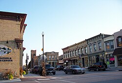
Sheboygan Falls is a city in Sheboygan County, Wisconsin, United States, along the Sheboygan River. The population was 8,210 at the 2020 census. It is part of the Sheboygan metropolitan area.
Sheboygan Falls took its name from the nearby falls on the Sheboygan River. The city was called Rochester for a brief time; the name was changed because a community in Racine County already held the same name. [4]
Sheboygan Falls is located along the Sheboygan River between its confluences with the Mullet and Onion Rivers near Lake Michigan. Rapids and a dam, which once supplied hydroelectric energy, prohibit most water transportation through the city.
According to the United States Census Bureau, the city has a total area of 5.41 square miles (14.01 km2), of which, 5.28 square miles (13.68 km2) is land and 0.13 square miles (0.34 km2) is water. [5]
Census | Pop. | Note | %± |
---|---|---|---|
1870 | 1,174 | — | |
1880 | 1,148 | −2.2% | |
1890 | 1,118 | −2.6% | |
1900 | 1,301 | 16.4% | |
1910 | 1,630 | 25.3% | |
1920 | 2,002 | 22.8% | |
1930 | 2,934 | 46.6% | |
1940 | 3,395 | 15.7% | |
1950 | 3,599 | 6.0% | |
1960 | 4,061 | 12.8% | |
1970 | 4,771 | 17.5% | |
1980 | 5,253 | 10.1% | |
1990 | 5,823 | 10.9% | |
2000 | 6,772 | 16.3% | |
2010 | 7,775 | 14.8% | |
2020 | 8,210 | 5.6% | |
U.S. Decennial Census [6] [ failed verification ] [3] |
This section needs to be updated. The reason given is: Newer information is available from the 2020 census report.(November 2021) |
As of the census [7] of 2010, there were 7,775 people, 3,480 households, and 2,152 families residing in the city. The population density was 1,472.5 inhabitants per square mile (568.5/km2). There were 3,681 housing units at an average density of 697.2 units per square mile (269.2 units/km2). The racial makeup of the city was 96.1% White, 0.6% African American, 0.3% Native American, 0.9% Asian, 0.8% from other races, and 1.4% from two or more races. Hispanic or Latino of any race were 2.5% of the population.
There were 3,480 households, of which 27.2% had children under the age of 18 living with them, 50.2% were married couples living together, 8.6% had a female householder with no husband present, 3.1% had a male householder with no wife present, and 38.2% were non-families. 33.0% of all households were made up of individuals, and 14.9% had someone living alone who was 65 years of age or older. The average household size was 2.22 and the average family size was 2.82.
The median age in the city was 42.6 years. 22.3% of residents were under the age of 18; 6% were between the ages of 18 and 24; 25.1% were from 25 to 44; 28.9% were from 45 to 64; and 17.7% were 65 years of age or older. The gender makeup of the city was 48.0% male and 52.0% female.
As of the census [8] of 2000, there were 6,772 people, 2,745 households, and 1,869 families residing in the city. The population density was 1,658.3 people per square mile (640.3 people/km2). There were 2,826 housing units at an average density of 692.0 units per square mile (267.2 units/km2). The racial makeup of the city was 98.05% White, 0.34% Black or African American, 0.31% Native American, 0.30% Asian, 0.30% from other races, and 0.71% from two or more races. 0.86% of the population were Hispanic or Latino of any race.
There were 2,745 households, out of which 31.7% had children under the age of 18 living with them, 58.4% were married couples living together, 7.1% had a female householder with no husband present, and 31.9% were non-families. 26.7% of all households were made up of individuals, and 9.5% had someone living alone who was 65 years of age or older. The average household size was 2.39 and the average family size was 2.91.
In the city, the population was spread out, with 23.9% under the age of 18, 7.4% from 18 to 24, 30.1% from 25 to 44, 22.7% from 45 to 64, and 15.9% who were 65 years of age or older. The median age was 39 years. For every 100 females, there were 91.9 males. For every 100 females age 18 and over, there were 91.1 males.
The median income for a household in the city was $47,205, and the median income for a family was $55,668. Males had a median income of $40,006 versus $25,293 for females. The per capita income for the city was $22,456. About 2.6% of families and 2.7% of the population were below the poverty line, including 3.3% of those under age 18 and 4.6% of those age 65 or over.
Major employers in Sheboygan Falls include: [9]
There are two business parks in Sheboygan Falls: Sheboygan Falls Industrial Park, which is privately owned and fully developed, is located about one mile from State Highway 23. Vision Business Park has 70 city-owned acres available for development. The park is located less than one mile from State Highway 23, on County Highways C and TT. [10]
Sheboygan County, the only county in Wisconsin designated a “Bicycle Friendly Community” by the League of American Bicyclists, [11] has built nearly 39 miles of off street bike trails and dozens of miles on on-street trails. The 17 mile Old Plank Road Trail runs from Sheboygan through Sheboygan Falls to Glenbeulah, WI. This trail doubles as a snowmobile trail in Winter.
Sheboygan Falls has six elected alderman from three districts elected for staggered two-year terms.
The community is served by the public system of the School District of Sheboygan Falls, which accomplished a 99.3% high school graduation rate, one of the highest in the nation. [12] The system has three schools consisting of an elementary school, (grades 4k-4), middle school (grades 5–8) and high school (grades 9–12) serving approximately 1,700 students. The district has received awards for its use in social media and newsletters to communicate with parents. The district does have summer school offerings for students who want to learn year round.
The elementary school is designated a Student Achievement Guarantee in Education school, [13] which guarantees class sizes of 19 students or fewer.
With 500 students, the middle schools offer several tracks for those who learn at different paces. [13] The school has programs in the arts, including drama and music clubs.
Families preferring private school education attend schools in Sheboygan, including Sheboygan County Christian High School and Sheboygan Lutheran High School; the city's Catholic school, St. Mary, closed in 2013 due to declining enrollment. [14]
Sheboygan Falls is served by Spectrum and AT&T U-verse for wired pay-TV service locally. WHBZ (106.5 FM) is licensed to Sheboygan Falls, though for all intents and purposes that mainstream rock station serves and originates from Sheboygan. Sheboygan-licensed station WCLB (950/107.3) has their transmitter towers located on the city's north side.
The City of Sheboygan Falls is located along State Highways 23, 28, and 32. The free-way style four-lane Highway 23 connects the community with Interstate 43 located less than five miles east of Sheboygan Falls.
A single-track railroad branch line between Plymouth and Sheboygan runs through the city. Built by the Chicago & North Western (C&NW) Railroad, the track originally paralleled the electric interurban Wisconsin Power & Light line which terminated at Elkhart Lake. [15] In later years it was primarily a freight line for the Chicago and North Western Transportation Company, and Union Pacific after UP acquired the C&NW in 1995. In 2006, citing low demand and degraded infrastructure, Union Pacific announced plans to abandon the line west of the Kohler Company factory in Kohler, thus terminating all service to Sheboygan Falls. In 2009, the Wisconsin Department of Transportation purchased the Plymouth-Sheboygan Falls portion of the line from Union Pacific, with the intent of repairing the long dormant line to allow the Wisconsin & Southern Railroad to provide restored service to Sheboygan Falls. [16]
The track through downtown Sheboygan Falls has been of interest to railfans because of a number of interesting features, including an iron trestle over the Sheboygan River, a small section of street running where the line runs at grade along city streets, and antiquated "wig-wag" signals at several crossings. Many of these features have been threatened because of the Union Pacific's abandonment of the line; the trestle has been barricaded and parts of the tracks leading to it have been removed, [17] and plans to restore the line for the resumption of service will require crossing signals to be upgraded. Wig wag signals have already been removed.
Sheboygan Falls is served by the Sheboygan County Memorial Airport (KSBM), which is located several miles north of the city. KSBM is the 7th busiest airport in Wisconsin with no commercial travel. The 700+ daily flight operations are primarily travel for business and pleasure, with its heaviest use from the Kohler Company, along with events at Road America and Whistling Straits. KSBM is capable of landing a 98,000 lbs. aircraft or a Boeing 737 with the longest concrete runway 6,800 feet long. The airport has fixed base operator with several private, industrial and commercial lots available for development. Milwaukee Mitchell International Airport (KMKE) is 64 mi away from Sheboygan Falls.
Sheboygan Falls was named one of the safest communities in Wisconsin by Safewise. [18] The Sheboygan Falls Police Department maintains a full-time police presence in the city, with an administrative staff of four, 11 sworn officers and Bo, the community's K-9 unit. The city has a volunteer fire department. Orange Cross Ambulance Station 3 is quartered with the volunteer fire department at the Municipal Building.
The city of Sheboygan Falls provides locally based water and sewerage services (both connected to Sheboygan's water/sewerage system and drawing water from Lake Michigan), along with electric service through Sheboygan Falls Utilities. Natural gas service is provided through Wisconsin Public Service Corporation.
Chippewa Falls is a city located on the Chippewa River in Chippewa County, Wisconsin, United States. The population was 14,731 in the 2020 census. Incorporated as a city in 1869, it is the county seat of Chippewa County.
Cornell is a city in Chippewa County, Wisconsin, United States. The population was 1,467 at the 2010 census. It is located on the Chippewa River, upstream from Lake Wissota and Chippewa Falls, where Highway 64 crosses the river and Highway 27.
Cleveland is a village in Manitowoc County, Wisconsin, United States. The population was 1,579 at the 2020 census.
Pembine is a town in Marinette County, Wisconsin, United States. The population was 877 at the 2020 census. The unincorporated community of Kremlin is located in the town, The census-designated place of Pembine is also located in the town.
Park Falls is a city in Price County, Wisconsin, United States. The population was 2,410 at the 2020 census, down from 2,462 at 2010. Located in the woods of north central Wisconsin, primarily the Chequamegon National Forest, Park Falls is a small community divided by the North Fork of the Flambeau River, a popular destination for fishing, canoeing and whitewater rafting.
Scott is a town in Sheboygan County, Wisconsin, United States. The population was 1,804 at the 2000 census. The unincorporated communities of Batavia, Beechwood, and Cranberry Marsh are located within the town. It is included in the Sheboygan, Wisconsin Metropolitan Statistical Area.
Waldo is a village along the Onion River in Sheboygan County, Wisconsin, United States. The population was 503 at the 2010 census. It has a post office with ZIP code 53093. It is included in the Sheboygan, Wisconsin Metropolitan Statistical Area.
Wilson is a town in Sheboygan County, Wisconsin, United States. The population was 3,227 at the 2000 census. The unincorporated community of Weedens is located in the town. It is included in the Sheboygan, Wisconsin Metropolitan Statistical Area.
Kiel is a city in Calumet and Manitowoc counties in the U.S. state of Wisconsin. The population was 3,738 at the 2010 census. Of this, 3,429 residents lived in Manitowoc County, and 309 residents lived in Calumet County. The city is located primarily within Manitowoc County, though a portion extends west into adjacent Calumet County and is known as "Hinzeville".
Plymouth is a town in Sheboygan County, Wisconsin. The population was 3,115 at the time of the 2000 census. It is included in the Sheboygan, Wisconsin Metropolitan Statistical Area. The City of Plymouth is located within the town, but is politically independent. The unincorporated community of New Paris is also located in the town.
Mondovi is a city along the Buffalo River in Buffalo County, Wisconsin, United States. The population was 2,777 at the 2010 census. The city is mostly surrounded by the Town of Mondovi, with a small portion surrounded by the Town of Naples.
Monroe is a city in and the county seat of Green County, Wisconsin, United States. The population was 10,661 at the 2020 census. The city is bordered by the town of Monroe to the north and the town of Clarno to the south. Monroe is a part of the Madison metropolitan area. It is nicknamed the "Cheese Capital of the USA".
Merrill is a city in and the county seat of Lincoln County, Wisconsin, United States. It is located to the south of and adjacent to the Town of Merrill. The population was 9,347, according to the 2020 census. Merrill is part of the United States Census Bureau's Merrill MSA, which includes all of Lincoln County. Together with the Wausau MSA, which includes all of Marathon County, it forms the Wausau-Merrill CSA.
Manitowoc is a city in and the county seat of Manitowoc County, Wisconsin, United States. The city is located on Lake Michigan at the mouth of the Manitowoc River. According to the 2020 census, Manitowoc had a population of 34,626.
River Falls is a city in Pierce and St. Croix counties in the U.S. state of Wisconsin. It is located mostly within the town of River Falls, and adjacent to the town of Kinnickinnic in St. Croix County. River Falls is the most populous city in Pierce County. The population was 16,182 at the 2020 census, with 12,546 residing in Pierce County and 3,636 in St. Croix County. It is part of the Minneapolis–St. Paul metropolitan area and located approximately 30 miles (48 km) east of the center of that region.
St. Croix Falls is a city in Polk County, Wisconsin, United States. The population was 2,208 at the 2020 census. The city is located within the Town of St. Croix Falls.
Plymouth is a city in Sheboygan County, Wisconsin, United States, along the Mullet River. The population was 8,932 at the 2020 census. It is included in the Sheboygan, Wisconsin metropolitan area. The city is located in the Town of Plymouth, but is politically independent. Plymouth was known as "Hub City" for its former role as a center of wooden wheelwrighting. It is now known as "The Cheese Capitol of the World" as it produces 40% of all the cheese consumed in the U.S. Mayor Don Pohlman was last re-elected in April 2018.
Sheboygan is a city in and the county seat of Sheboygan County, Wisconsin, United States. The population was 49,929 at the 2020 census. It is the principal city of the Sheboygan metropolitan area, which has a population of 118,034. The city is located on the western shore of Lake Michigan at the mouth of the Sheboygan River, about 50 miles north of Milwaukee and 64 mi (103 km) south of Green Bay.
Sheboygan Falls is a town located in Sheboygan County, Wisconsin, United States. As of the 2000 census, the town had a total population of 1,706. It is included in the Sheboygan, Wisconsin Metropolitan Statistical Area. The unincorporated community of Johnsonville is located in the town 5 miles northwest from the city.
Black River Falls is a city in and the county seat of Jackson County, Wisconsin, United States. The population was 3,523 at the 2020 census. It is home to the administrative center of the Ho-Chunk Nation.