Oostburg, Wisconsin

Last updated

Oostburg, Wisconsin
The Burg
Village of Oostburg
Sheboygan County Wisconsin Incorporated and Unincorporated areas Oostburg Highlighted.svg
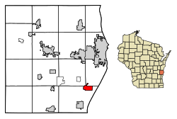
Location of Oostburg in Sheboygan County, Wisconsin.
Coordinates: 43°37′27″N87°47′52″W / 43.62417°N 87.79778°W / 43.62417; -87.79778
Country United States
State Wisconsin
County Sheboygan
Government
   President Adam Dykstra [1]
Area
[2]
  Total1.96 sq mi (5.08 km2)
  Land1.96 sq mi (5.08 km2)
  Water0.00 sq mi (0.00 km2)
Elevation
[3]
699 ft (213 m)
Population
 (2020) [4]
  Total3,056
  Density1,542.81/sq mi (595.69/km2)
Time zone UTC-6 (Central (CST))
  Summer (DST) UTC-5 (CDT)
Area code 920
FIPS code 55-60100 [5]
GNIS feature ID1570842 [3]
Website www.oostburg.org

Oostburg is a village in Sheboygan County, Wisconsin, United States. The population was 3,056 at the 2020 census. It is included in the Sheboygan, Wisconsin Metropolitan Statistical Area.

Contents

History

The Village of Oostburg was incorporated in 1909. [6] It was settled by primarily Dutch immigrants, [7] and named after a city in the Netherlands. [8] [9]

Education

The Oostburg School District operates the Oostburg Elementary School, Oostburg Middle School and the Oostburg High School. Oostburg Christian School is a private school located within the village.

Geography

Oostburg is located at 43°37′27″N87°47′52″W / 43.62417°N 87.79778°W / 43.62417; -87.79778 (43.624256, -87.797666). [10]

According to the United States Census Bureau, the village has a total area of 1.95 square miles (5.05 km2), all land. [11]

Demographics

Historical population
CensusPop.Note
1910 380
1920 49730.8%
1930 67135.0%
1940 74210.6%
1950 89520.6%
1960 1,06519.0%
1970 1,30922.9%
1980 1,64725.8%
1990 1,93117.2%
2000 2,66037.8%
2010 2,8878.5%
2020 3,0565.9%
U.S. Decennial Census [12]

2010 census

As of the census [4] of 2010, there were 2,887 people, 1,091 households, and 826 families living in the village. The population density was 1,480.5 inhabitants per square mile (571.6/km2). There were 1,154 housing units at an average density of 591.8 per square mile (228.5/km2). The racial makeup of the village was 95.7% white, 0.7% African American, 0.3% Native American, 0.7% Asian, 1.8% from other races, and 0.8% from two or more races. Hispanic or Latino of any race were 3.3% of the population.

There were 1,091 households, of which 35.9% had children under the age of 18 living with them, 67.5% were married couples living together, 6.1% had a female householder with no husband present, 2.1% had a male householder with no wife present, and 24.3% were non-families. 21.9% of all households were made up of individuals, and 10.8% had someone living alone who was 65 years of age or older. The average household size was 2.64 and the average family size was 3.10.

The median age in the village was 38.3 years. 27.9% of residents were under the age of 18; 6.2% were between the ages of 18 and 24; 25.2% were from 25 to 44; 25% were from 45 to 64; and 15.5% were 65 years of age or older. The gender makeup of the village was 49.9% male and 50.1% female.

2000 census

As of the census [5] of 2000, there were 2,660 people, 980 households, and 761 families living in the village. The population density was 1,416.2 people per square mile (546.3/km2). There were 996 housing units at an average density of 530.3 per square mile (204.6/km2). The racial makeup of the village was 99.10% white, 0.15% African American, 0.08% Native American, 0.30% Asian, 0.15% from other races, and 0.23% from two or more races. Hispanic or Latino of any race were 1.24% of the population.

There were 980 households, out of which 38.3% had children under the age of 18 living with them, 71.4% were married couples living together, 4.8% had a female householder with no husband present, and 22.3% were non-families. 20.0% of all households were made up of individuals, and 10.5% had someone living alone who was 65 years of age or older. The average household size was 2.71 and the average family size was 3.14.

In the village, the population was spread out, with 29.6% under the age of 18, 7.3% from 18 to 24, 29.9% from 25 to 44, 18.1% from 45 to 64, and 15.2% who were 65 years of age or older. The median age was 34 years. For every 100 females, there were 100.0 males. For every 100 females age 18 and over, there were 95.3 males.

The median income for a household in the village was $47,469, and the median income for a family was $58,654. Males had a median income of $40,975 versus $25,478 for females. The per capita income for the village was $19,958. None of the families and 0.8% of the population were living below the poverty line, including no under eighteens and 1.7% of those over 64.

Notable people

Related Research Articles

<span class="mw-page-title-main">Tanaina, Alaska</span> CDP in Alaska, United States

Tanaina is a census-designated place (CDP) in the Matanuska-Susitna Borough in the U.S. state of Alaska. Located 4 miles north from Wasilla, it is part of the Anchorage, Alaska Metropolitan Statistical Area. At the 2020 census the population was 8,817, up from 8,197 in 2010. Tanaina is the sixth-most populated CDP in Alaska.

<span class="mw-page-title-main">Chuichu, Arizona</span> CDP in Pinal County, Arizona

Chuichu is a census-designated place (CDP) in Pinal County, Arizona, United States. The population was 308 at the 2020 census. It is the northernmost traditional village on the Tohono O'odham Nation reservation.

<span class="mw-page-title-main">Fairview, Westchester County, New York</span> CDP in New York, United States

Fairview is a hamlet and a census-designated place (CDP) located in the town of Greenburgh, Westchester County, New York, United States. The population was 3,099 at the 2010 census. As of 2000, Fairview had the fourth-highest percentage of African-Americans in New York.

<span class="mw-page-title-main">Coolville, Ohio</span> Village in Ohio, United States

Coolville is a village located in Troy Township, Athens County, Ohio, United States, in the southeast area of the state. The population was 452 at the 2020 census.

<span class="mw-page-title-main">Port Washington, Ohio</span> Village in Ohio, United States

Port Washington is a village in Tuscarawas County, Ohio, United States. The population was 548 at the 2020 census.

<span class="mw-page-title-main">Eau Claire, Pennsylvania</span> Borough in Pennsylvania, United States

Eau Claire is a borough in Butler County, Pennsylvania, United States. The population was 316 at the 2010 census. The name means "Clear Water" in French, and the name is pronounced as though it were spelled "U'Clare".

<span class="mw-page-title-main">Winterstown, Pennsylvania</span> Borough in Pennsylvania, United States

Winterstown is a borough in York County, Pennsylvania, United States. The population was 609 at the time of the 2020 census.

<span class="mw-page-title-main">Cleveland (village), Wisconsin</span> Village in Wisconsin, United States

Cleveland is a village in Manitowoc County, Wisconsin, United States. The population was 1,579 at the 2020 census.

<span class="mw-page-title-main">Bohners Lake, Wisconsin</span> CDP in Wisconsin, United States

Bohners Lake is a census-designated place (CDP) in Racine County, Wisconsin, United States. Its first syllable is pronounced as in "bone". The population of the CDP was 2,374 at the 2020 census. It is politically part of the Town of Burlington, together with Browns Lake, Wisconsin. There has been discussion of incorporating Bohners Lake as a village to prevent annexation by the City of Burlington. It was named for Antony Bohner, a French immigrant who established a resort on the lake of the same name.

<span class="mw-page-title-main">Adell, Wisconsin</span> Village in Wisconsin, United States

Adell is a village in Sheboygan County, Wisconsin, United States. The population was 516 at the 2010 census. It is included in the Sheboygan, Wisconsin Metropolitan Statistical Area.

<span class="mw-page-title-main">Cascade, Wisconsin</span> Village in Wisconsin, United States

Cascade is a village in Sheboygan County, Wisconsin, United States. The population was 709 at the 2010 census. It is included in the Sheboygan, Wisconsin Metropolitan Statistical Area. Wisconsin Highway 28 passes through Cascade.
<span class="mw-page-title-main">Cedar Grove, Wisconsin</span> Village in Wisconsin, United States

Cedar Grove is a village in Sheboygan County, Wisconsin, United States, within the Town of Holland. The population was 2,101 at the 2020 census. It is included in the Sheboygan, Wisconsin Metropolitan Statistical Area.

<span class="mw-page-title-main">Glenbeulah, Wisconsin</span> Village in Wisconsin, United States

Glenbeulah is a village in Sheboygan County, Wisconsin, United States. The population was 463 at the 2010 census. It is included in the Sheboygan, Wisconsin Metropolitan Statistical Area. Glenbeulah is situated on the Mullet River.

<span class="mw-page-title-main">Holland, Sheboygan County, Wisconsin</span> Town in Wisconsin, United States

Holland is a town in Sheboygan County, Wisconsin, United States. The population was 2,360 at the 2000 census. It is included in the Sheboygan, Wisconsin Metropolitan Statistical Area. The unincorporated community of Idlewood Beach is located in the town. The unincorporated community of Dacada is also located partially in the town.

<span class="mw-page-title-main">Kohler, Wisconsin</span> Village in Wisconsin, United States

Kohler is a village in Sheboygan County, Wisconsin, United States, along the Sheboygan River. The population was 2,120 at the 2010 census. It is included in the Sheboygan, Wisconsin Metropolitan Statistical Area.

<span class="mw-page-title-main">Random Lake, Wisconsin</span> Village in Wisconsin, United States

Random Lake is a village in Sheboygan County, Wisconsin, United States. The population was 1,594 at the 2010 census. It is part of the Sheboygan, Wisconsin Metropolitan Statistical Area.
<span class="mw-page-title-main">Rhine, Wisconsin</span> Town in Wisconsin, United States

Rhine is a town in Sheboygan County, Wisconsin, United States. The population was 2,244 at the 2000 census. The village of Elkhart Lake is located within the town. The unincorporated community of Rhine Center is also located in the town. The town is included in the Sheboygan, Wisconsin Metropolitan Statistical Area.

<span class="mw-page-title-main">Waldo, Wisconsin</span> Village in Wisconsin, United States

Waldo is a village along the Onion River in Sheboygan County, Wisconsin, United States. The population was 503 at the 2010 census. It has a post office with ZIP code 53093. It is included in the Sheboygan, Wisconsin Metropolitan Statistical Area.

<span class="mw-page-title-main">Liberty (village), New York</span> Village in New York, United States

Liberty is a village in Sullivan County, New York, United States. The population was 4,700 at the 2020 census.

<span class="mw-page-title-main">Sheboygan Falls (town), Wisconsin</span> Town in Wisconsin, United States

Sheboygan Falls is a town located in Sheboygan County, Wisconsin, United States. As of the 2000 census, the town had a total population of 1,706. It is included in the Sheboygan, Wisconsin Metropolitan Statistical Area. The unincorporated community of Johnsonville is located in the town.
References

  1. "Village of Oostburg Local Directory" (PDF). Archived from the original (PDF) on May 13, 2008.
  2. "2019 U.S. Gazetteer Files". United States Census Bureau. Retrieved August 7, 2020.
  3. 1 2 "US Board on Geographic Names". United States Geological Survey. October 25, 2007. Retrieved January 31, 2008.
  4. 1 2 "U.S. Census website". United States Census Bureau . Retrieved November 18, 2012.
  5. 1 2 "U.S. Census website". United States Census Bureau . Retrieved January 31, 2008.
  6. "Village of Oostburg" . Retrieved January 23, 2023.
  7. "Alienated America".
  8. Chicago and North Western Railway Company (1908). A History of the Origin of the Place Names Connected with the Chicago & North Western and Chicago, St. Paul, Minneapolis & Omaha Railways. p. 110.
  9. Timothy P. Carney (February 16, 2019). "The One Trait That Predicts Trump Fever. Oostburg and Chevy Chase couldn't be more different. But in the 2016 primary, they both rejected Trump. They have something else in common, too". politico.com. Retrieved February 16, 2019.
  10. "US Gazetteer files: 2010, 2000, and 1990". United States Census Bureau. February 12, 2011. Retrieved April 23, 2011.
  11. "US Gazetteer files 2010". United States Census Bureau. Archived from the original on February 20, 2011. Retrieved November 18, 2012.
  12. "Census of Population and Housing". Census.gov. Retrieved June 4, 2015.
  13. 'Peter Daane Is Dead,' Sheboygan Press, January 8, 1914, pg. 1,5
  14. Votesmart.org.-Devin LeMahieu