The area now known as Sidney was inhabited by the Husatunnuk [3] prior to its "purchase" from Goldsboro Banyar, of Albany, in 1771 by Rev. William Johnston, Presbyterian, born in Dublin, Ireland. [3] The town was then called "Johnston" settlement until its renaming in 1801. [4] The village was named for Admiral Sir Sidney Smith.[5]
It is located nearly equidistant from Oneonta to the northeast, in the direction of the state capital Albany, and Binghamton to the southwest via I-88. Its position on the Susquehanna River makes it witness to the annual General Clinton Canoe Regatta. [6]
The largest local employer today is Amphenol followed by Keith Clark [4] though the latter is reported to be closing.
The town has also felt the loss of a local grocery, Price Chopper remains, and Kmart, as its manufacturing overall has declined over the last couple of decades.
It's local hospital, now part of Bassett A.O. Fox Hospital – Tri-Town Campus, has been closed except for the daytime critical care center. [3] Two other outpatient clinics are also present nearby.
The town continues to maintain its own local schools, library, EMS and fire district. [4]
In June 2006, Sidney, along with other parts of New York and Pennsylvania, was hit by severe flooding. Carr's Creek washed out a 50-foot-long (15m) section of Interstate 88 east of Sidney. At around 6:20am on Wednesday, June 28, two trucks from different directions drove into the chasm, apparently unaware of it, killing both drivers. David Swingle, 42, of Waverly, New York, who was driving westbound, was identified shortly after the accident. The eastbound trucker was Patrick O'Connell, 55, of Lisbon, Maine. His body was found downstream several days after the water receded.
The New York State Department of Transportation finished preliminary repairs on I-88 by the end of 2006. Additional construction was completed within the next year due to the settling of the highway.
The village itself was also flooded, particularly the westernmost part of the town on the south side of the Susquehanna River. Hardest hit were parts of Willow, Maple, Oak, Winegard, Bridge and River streets, some of which took on over 4 feet (1.2m) of muddy water during the flood. Many other areas were also affected. The entire downtown area north of the railroad tracks was evacuated because of the rising levels of the Susquehanna River.
According to the United States Census Bureau, the village of Sidney has a total area of 2.4 square miles (6.2km2), of which 0.02 square miles (0.04km2), or 0.64%, is water.[2]
Interstate 88 passes just south of the village, with access from Exit 9 (New York State Route 8). I-88 leads northeast 23 miles (37km) to Oneonta and southwest 36 miles (58km) to Binghamton. Route 8 leads north 62 miles (100km) to Utica and south 21 miles (34km) to Deposit.
At the 2010 census, the population was 3,900 (1,835 males, 2,065 females). The median age was 41.5 years, with 6.6% of the population under 5 years and 3.5% of the population 85 years and over. The age range with the lowest percentage of the population was 80 to 84 years with 2.3%. The age range with the highest percentage of the population was 50 to 54 years with 7.7%.[10]
There were 1,697 households (1,005 family households and 692 non-family households) in the village. The average household size was 2.28 and the average family size was 2.90.[10] The U.S. Census Bureau uses the following definitions: "Family households" consist of a householder and one or more other people related to the householder by birth, marriage, or adoption. They do not include same-sex married couples even if the marriage was performed in a state issuing marriage certificates for same-sex couples. Same-sex couple households are included in the family households category if there is at least one additional person related to the householder by birth or adoption. Same-sex couple households with no relatives of the householder present are tabulated in nonfamily households. "Nonfamily households" consist of people living alone and households which do not have any members related to the householder.[10]
At the 2000 census,[11] there were 4,068 people, 1,748 households and 1,054 families residing in the village. The population density was 1,722.7 per square mile (665.1/km2). There were 1,951 housing units at an average density of 826.2 per square mile (319.0/km2). The racial make-up was 95.99% White, 0.91% Black or African American, 0.42% Native American, 0.96% Asian, 0.02% Pacific Islander, 0.34% from other races and 1.35% from two or more races. Hispanic or Latino of any race were 1.52% of the population.
There were 1,748 households, of which 30.4% had children under the age of 18 living with them, 42.1% were married couples living together, 14.0% had a female householder with no husband present, and 39.7% were non-families. 33.8% of all households were made up of individuals, and 18.0% had someone living alone who was 65 years of age or older. The average household size was 2.29 and the average family size was 2.92.
25.8% of the population were under the age of 18, 7.2% from 18 to 24, 24.6% from 25 to 44, 22.9% from 45 to 64 and 19.5% who were 65 years of age or older. The median age was 40 years. For every 100 females, there were 86.7 males. For every 100 females age 18 and over, there were 82.5 males.
The median household income was $27,411 and the median family income was $31,734. Males had a median income of $28,596 and females $23,125. The per capita income was $15,123. About 15.4% of families and 18.5% of the population were below the poverty line, including 27.8% of those under age 18 and 12.9% of those age 65 or over.
Notable people
Lt. Col. Evans Carlson, US Marine Corps, leader of "Carlson's Rangers" in World War II
Lake Summerset is a census-designated place (CDP) in Stephenson and Winnebago counties in Illinois. The population was 2,048 at the 2010 census.
Whaleyville [weɪliːvɪl] is a census-designated place in Worcester County, Maryland, United States. The population was 149 at the 2010 census. It is part of the Salisbury, Maryland-Delaware Metropolitan Statistical Area.
Lincklaen is a town in Chenango County, New York, United States. The population was 392 at the 2020 census. The town was named after Colonel John Lincklaen, an agent of the Holland Land Company and a land owner. The town is in the northwestern corner of the county, northwest of the city Norwich and northeast of Cortland.
Harpersfield is a town in Delaware County, New York, United States. The population was 1,442 at the 2020 census. The town is on the northern border of the county.
Masonville is a town in Delaware County, New York, United States. The population was 1,239 at the 2020 census. The town is in the western part of the county.
Meredith is a town in Delaware County, New York, United States. The population was 1,484 at the 2020 census. It is an interior town in the northern part of the county.
Jefferson is a town in Schoharie County, New York, United States. The population was 1,333 at the 2020 census. The town is on the southwestern border of the county and is east of Oneonta.
Village Green-Green Ridge is a census-designated place (CDP) in Aston Township, Delaware County, Pennsylvania, United States. The population was 7,822 at the 2010 census, down from 8,279 at the 2000 census.
Rewey is a village in Iowa County, Wisconsin, United States. The population was 258 at the 2020 census. It is part of the Madison Metropolitan Statistical Area.
Afton is a village in Chenango County, New York, United States. The population was 822 at the 2010 census. The village is named after the poem "Sweet Afton" by Scottish poet Robert Burns, referring to the River Afton in Ayrshire, Scotland.
Bainbridge is a village in Chenango County, New York, United States. The population was 1,355 at the 2010 census. The village is at the center of the town of Bainbridge and lies between Binghamton and Oneonta.
Bainbridge is a town in Chenango County, New York, United States. The population was 3,308 at the 2010 census. The town is at the eastern border of Chenango County, halfway between Binghamton and Oneonta.
New Berlin is a village in Chenango County, New York, United States. The population was 1,028 at the 2010 census. The village is by the eastern town line of the town of New Berlin and is northeast of Norwich.
Hancock is a village in Delaware County, New York, United States. The population was 908 at the 2020 census. The village is in the west part of the town of Hancock at the junction of NY Routes 17 and 97.
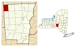
Sidney is a town in Delaware County, New York, United States. The population was 5,536 at the 2020 census. The town is at the northwestern corner of the county and contains the village of Sidney.
Stamford is a village in Delaware County, New York, United States. The population was 1,119 at the 2010 census. The village is located partly in the town of Stamford and partly in the town of Harpersfield. The village is on routes 23 and 10. The village has termed itself the "Queen of the Catskills".
Oneonta is a town in Otsego County, New York, United States. The population was 5,065 at the 2020 census.,
Otego is a town located in the southwest portion of Otsego County, New York, United States. The population was 3,115 at the 2010 census. The name is a native word meaning "where there is fire."
Unadilla is a village located in the town of Unadilla in Otsego County, New York, United States. The population was 1,128 at the 2010 census. The village is located in the southern part of the town, southwest of Oneonta. The community nickname is, "The Village Beautiful."
Unadilla is a town in Otsego County, New York, United States. As of the 2010 census, the town had a population of 4,392. The name is derived from an Iroquois word for "meeting place". Unadilla is located in the southwestern corner of the county, southwest of Oneonta. The village of Unadilla is located in the southern part of the town. The mayor of Unadilla is Jason Cotten.
This page is based on this Wikipedia article Text is available under the CC BY-SA 4.0 license; additional terms may apply. Images, videos and audio are available under their respective licenses.