
Montpelier is the capital of the U.S. state of Vermont and the county seat of Washington County. The site of Vermont's state government, it is the least populated state capital in the United States. As of the 2020 census, the population was 8,074, with a daytime population growth of about 21,000 due to the large number of jobs within city limits. The Vermont College of Fine Arts is located in the municipality. It was named after Montpellier, a city in the south of France.

Royalton is a town in Windsor County, Vermont, United States. The population was 2,750 at the 2020 census. It includes the villages of Royalton, South Royalton, and North Royalton. Vermont Law School, the state's only accredited law school, is located in South Royalton.
Hudson is a town in Hillsborough County, New Hampshire, United States. It is located along the Massachusetts state line. The population was 25,394 at the 2020 census. It is the tenth-largest municipality in the state, by population.

Judiciary Square is a neighborhood in the northwest quadrant of Washington, D.C., the vast majority of which is occupied by various federal and municipal courthouses and office buildings. Judiciary Square is located roughly between Pennsylvania Avenue to the south, H Street to the north, 6th Street to the west, and 3rd Street to the east. The center of the neighborhood is an actual plaza named Judiciary Square. The Square itself is bounded by 4th Street to the east, 5th Street to the west, D Street and Indiana Avenue to the south, and F Street to the north. The neighborhood is served by the Judiciary Square station on the Red Line of the Washington Metro, in addition to Washington Metropolitan Area Transit Authority bus stops.
The Royalton raid was a British-led Indian raid in 1780 against various towns along the White River Valley in the Vermont Republic, and was part of the American Revolutionary War. It was the last major Indian raid in New England.

The Ogle County Courthouse is a National Register of Historic Places listing in the Ogle County, Illinois, county seat of Oregon. The building stands on a public square in the city's downtown commercial district. The current structure was completed in 1891 and was preceded by two other buildings, one of which was destroyed by a group of outlaws. Following the destruction of the courthouse, the county was without a judicial building for a period during the 1840s. The Ogle County Courthouse was designed by Chicago architect George O. Garnsey in the Romanesque Revival style of architecture. The ridged roof is dominated by its wooden cupola which stands out at a distance.
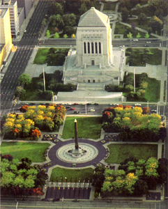
The Indiana World War Memorial Plaza is an urban feature and war memorial located in downtown Indianapolis, Indiana, United States, originally built to honor the veterans of World War I. It was conceived in 1919 as a location for the national headquarters of the American Legion and a memorial to the state's and nation's veterans.

South Royalton is an unincorporated village and census-designated place (CDP) in the town of Royalton, Windsor County, Vermont, United States. With a population at the 2010 census of 694, South Royalton is the largest community in the town. It is home to the Vermont Law School. The central portion of the village is a historic district, listed on the National Register of Historic Places as the South Royalton Historic District. The Joseph Smith Birthplace Memorial is located approximately two miles to the east. South Royalton is the town pictured in the opening credits of the WB television show Gilmore Girls.

The Oregon Korean War Memorial is a war memorial located in Wilsonville, Oregon, United States. Completed in 2000, it honors the Oregon soldiers and the Korean people from the Korean War. The memorial is located within a 5.5-acre (22,000 m2) city park and features a 109-foot (33 m)-long granite wall that includes the names of those Oregonians who died or were listed as missing from the war.

The Darlington Memorial Fountain, also known as the Joseph Darlington Fountain, Nymph and Fawn, and Darlington Fountain, is a sculpture by C. Paul Jennewein atop a fountain in honor of Joseph James Darlington. It is located at Judiciary Park, where 5th Street, D Street, and Indiana Avenue NW intersect in the Judiciary Square neighborhood of Washington, D.C. The fountain is surrounded on three sides by government buildings, including the United States Court of Military Appeals, the H. Carl Moultrie Courthouse, and the former District of Columbia City Hall.
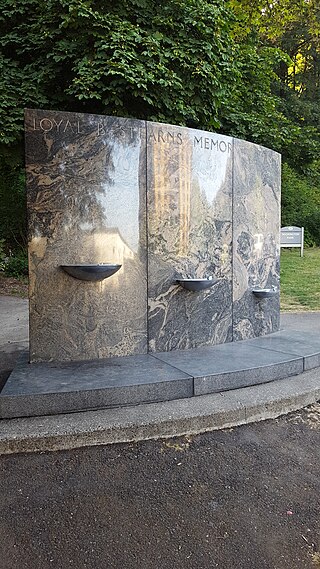
The Loyal B. Stearns Memorial Fountain, also known as the Judge Loyal B. Stearns Memorial Fountain, is an outdoor 1941 drinking fountain and sculpture by the design firm A. E. Doyle and Associates, located in Portland, Oregon. It was erected in Washington Park in honor of the former Oregon judge Loyal B. Stearns.

Vermont Route 110 (VT 110) is a state highway in the U.S. state of Vermont. The highway runs 27.136 miles (43.671 km) from VT 14 in Royalton in northern Windsor County north to U.S. Route 302 in the town of Barre in central Washington County. VT 110 follows the valley of the First Branch White River through the Orange County towns of Tunbridge and Chelsea, which contain multiple historic buildings and covered bridges. The highway also follows the Jail Branch River, a tributary of the Winooski River, through Washington and Orange.

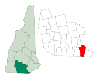
The South Royalton Historic District encompasses the central portion of the village of South Royalton, Vermont. Now the town of Royalton's principal commercial center, it developed in the second half of the 19th century around the depot of the Vermont Central Railroad. The district includes fine examples of Greek Revival and Victorian architecture, and is home to the Vermont Law School. It was listed on the National Register of Historic Places in 1976.

The Darling Estate Historic Estate encompasses an historic country estate of more than 2,000 acres (810 ha) on Darling Hill Road, straddling the town line between Burke and Lyndon, Vermont. Built in the early 1900s for Elmer Darling, a locally-born New York hotelier, it was one of Vermont's largest such estates, featuring Burklyn Hall, one of its most opulent Colonial Revival houses, as well as numerous 19th-century farm properties. It was listed on the National Register of Historic Places in 2011.

The Downtown Hardwick Village Historic District encompasses a significant portion of the downtown area of Hardwick, Vermont. The town developed in the 19th century first as a small industrial center, and later became one of the world's leading processors of granite. The district was listed on the National Register of Historic Places in 1982.

The Francestown Town Hall and Academy and Town Common Historic District encompasses a collection of historic 18th and 19th-century civic resources in the center of Francestown, New Hampshire. Located at the junction of New Boston and Greenfield Roads are the town's 1846 Greek Revival town hall and academy building, a former academic dormitory building, and the town's historic common, which includes a rare example of an early 20th-century platform scale. The district was listed on the National Register of Historic Places in 2016.
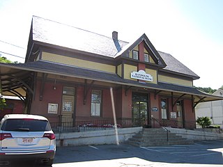
The South Royalton Railroad Station is a former train station in the community of South Royalton, Vermont. The 1886 station building still stands, used as a local bank branch of Bar Harbor Bank & Trust. It is a contributing property to the South Royalton Historic District, on the National Register of Historic Places.

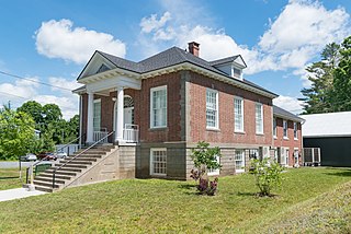
Debevoise Hall is the main academic building of the Vermont Law School, in South Royalton, Vermont. The Queen Anne-style structure was built in 1892 as Royalton's schoolhouse, and became the law school's first building in 1973. The building contributes to the South Royalton Historic District, on the National Register of Historic Places..
The Royalton Memorial Library is a public library in South Royalton, Vermont. The library organization was founded in 1917; its building was built from 1919 to 1924 and was expanded in 2020.

The Chelsea Street Bridge is a bridge in South Royalton, Vermont, spanning over the White River. The original bridge was constructed in 1848, followed by several replacements. The current bridge was completed in 2002.


