The Laboratory for Atmospheric and Space Physics (LASP) is a research organization at the University of Colorado Boulder. LASP is a research institute with over one hundred research scientists ranging in fields from solar influences, to Earth's and other planetary atmospherics processes, space weather, space plasma and dusty plasma physics. LASP has advanced technical capabilities specializing in designing, building, and operating spacecraft and spacecraft instruments.

The mesosphere is the third layer of the atmosphere, directly above the stratosphere and directly below the thermosphere. In the mesosphere, temperature decreases as altitude increases. This characteristic is used to define limits: it begins at the top of the stratosphere, and ends at the mesopause, which is the coldest part of Earth's atmosphere, with temperatures below −143 °C. The exact upper and lower boundaries of the mesosphere vary with latitude and with season, but the lower boundary is usually located at altitudes from 47 to 51 km above sea level, and the upper boundary is usually from 85 to 100 km.
The mesopause is the point of minimum temperature at the boundary between the mesosphere and the thermosphere atmospheric regions. Due to the lack of solar heating and very strong radiative cooling from carbon dioxide, the mesosphere is the coldest region on Earth with temperatures as low as -100 °C. The altitude of the mesopause for many years was assumed to be at around 85 km (53 mi), but observations to higher altitudes and modeling studies in the last 10 years have shown that in fact there are two mesopauses - one at about 85 km and a stronger one at about 100 km (62 mi), with a layer of slightly warmer air between them.

The atmosphere of Earth is composed of a layer of gas mixture that surrounds the Earth's planetary surface, known collectively as air, with variable quantities of suspended aerosols and particulates, all retained by Earth's gravity. The atmosphere serves as a protective buffer between the Earth's surface and outer space, shields the surface from most meteoroids and ultraviolet solar radiation, keeps it warm and reduces diurnal temperature variation through heat retention, redistributes heat and moisture among different regions via air currents, and provides the chemical and climate conditions allowing life to exist and evolve on Earth.

STS-66 was a Space Shuttle program mission that was flown by the Space Shuttle Atlantis. STS-66 launched on November 3, 1994, at 11:59:43.060 am EDT from Launch Pad 39-B at NASA's Kennedy Space Center. Atlantis landed at Edwards Air Force Base on November 14, 1994, at 10:33:45 am EST.

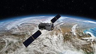
The Upper Atmosphere Research Satellite (UARS) was a NASA-operated orbital observatory whose mission was to study the Earth's atmosphere, particularly the protective ozone layer. The 5,900-kilogram (13,000 lb) satellite was deployed from Space Shuttle Discovery during the STS-48 mission on 15 September 1991. It entered Earth orbit at an operational altitude of 600 kilometers (370 mi), with an orbital inclination of 57 degrees.

Noctilucent clouds (NLCs), or night shining clouds, are tenuous cloud-like phenomena in the upper atmosphere of Earth. When viewed from space, they are called polar mesospheric clouds (PMCs), detectable as a diffuse scattering layer of water ice crystals near the summer polar mesopause. They consist of ice crystals and from the ground are only visible during astronomical twilight. Noctilucent roughly means "night shining" in Latin. They are most often observed during the summer months from latitudes between ±50° and ±70°. Too faint to be seen in daylight, they are visible only when the observer and the lower layers of the atmosphere are in Earth's shadow, but while these very high clouds are still in sunlight. Recent studies suggest that increased atmospheric methane emissions produce additional water vapor through chemical reactions once the methane molecules reach the mesosphere – creating, or reinforcing existing, noctilucent clouds.

Within the atmospheric sciences, atmospheric physics is the application of physics to the study of the atmosphere. Atmospheric physicists attempt to model Earth's atmosphere and the atmospheres of the other planets using fluid flow equations, radiation budget, and energy transfer processes in the atmosphere. In order to model weather systems, atmospheric physicists employ elements of scattering theory, wave propagation models, cloud physics, statistical mechanics and spatial statistics which are highly mathematical and related to physics. It has close links to meteorology and climatology and also covers the design and construction of instruments for studying the atmosphere and the interpretation of the data they provide, including remote sensing instruments. At the dawn of the space age and the introduction of sounding rockets, aeronomy became a subdiscipline concerning the upper layers of the atmosphere, where dissociation and ionization are important.
This is a list of meteorology topics. The terms relate to meteorology, the interdisciplinary scientific study of the atmosphere that focuses on weather processes and forecasting.
Aeronomy is the scientific study of the upper atmosphere of the Earth and corresponding regions of the atmospheres of other planets. It is a branch of both atmospheric chemistry and atmospheric physics. Scientists specializing in aeronomy, known as aeronomers, study the motions and chemical composition and properties of the Earth's upper atmosphere and regions of the atmospheres of other planets that correspond to it, as well as the interaction between upper atmospheres and the space environment. In atmospheric regions aeronomers study, chemical dissociation and ionization are important phenomena.

The atmosphere of Mars is the layer of gases surrounding Mars. It is primarily composed of carbon dioxide (95%), molecular nitrogen (2.85%), and argon (2%). It also contains trace levels of water vapor, oxygen, carbon monoxide, hydrogen, and noble gases. The atmosphere of Mars is much thinner and colder than Earth's having a max density 20g/m3 with a temperature generally below zero down to -60 Celsius. The average surface pressure is about 610 pascals (0.088 psi) which is 0.6% of the Earth's value.
The homosphere is the layer of an atmosphere where the bulk gases are homogeneously mixed due to turbulent mixing or eddy diffusion. The bulk composition of the air is mostly uniform so the concentrations of molecules are the same throughout the homosphere. The top of the homosphere is called the homopause, also known as the turbopause. Above the homopause is the heterosphere, where diffusion is faster than mixing, and heavy gases decrease in density with altitude more rapidly than lighter gases.

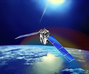
The Aeronomy of Ice in the Mesosphere was a NASA satellite launched in 2007 to conduct a planned 26-month study of noctilucent clouds (NLCs). It is the ninetieth Explorer program mission and is part of the NASA-funded Small Explorer program (SMEX).

The atmosphere of Venus is the very dense layer of gasses surrounding the planet Venus. Venus's atmosphere is composed of 96.5% carbon dioxide and 3.5% nitrogen, with other chemical compounds present only in trace amounts. It is much denser and hotter than that of Earth; the temperature at the surface is 740 K, and the pressure is 93 bar (1,350 psi), roughly the pressure found 900 m (3,000 ft) under water on Earth. The atmosphere of Venus supports decks of opaque clouds of sulfuric acid that cover the entire planet, preventing optical Earth-based and orbital observation of the surface. Information about surface topography has been obtained exclusively by radar imaging.

The Solar Mesosphere Explorer was a 1980s NASA spacecraft to investigate the processes that create and destroy ozone in Earth's upper atmosphere. The mesosphere is a layer of the atmosphere extending from the top of the stratosphere to an altitude of about 80 km (50 mi). The spacecraft carried five instruments to measure ozone, water vapor, and incoming solar radiation.

Greenhouse gas monitoring is the direct measurement of greenhouse gas emissions and levels. There are several different methods of measuring carbon dioxide concentrations in the atmosphere, including infrared analyzing and manometry. Methane and nitrous oxide are measured by other instruments. Greenhouse gases are measured from space such as by the Orbiting Carbon Observatory and networks of ground stations such as the Integrated Carbon Observation System.

SAGE III on ISS is the fourth generation of a series of NASA Earth-observing instruments, known as the Stratospheric Aerosol and Gas Experiment. The first SAGE III instrument was launched on a Russian Meteor-3M satellite. The recently revised SAGE III was mounted to the International Space Station where it uses the unique vantage point of ISS to make long-term measurements of ozone, aerosols, water vapor, and other gases in Earth's atmosphere.

Global-scale Observations of the Limb and Disk (GOLD) is a heliophysics Mission of Opportunity (MOU) for NASA's Explorers program. Led by Richard Eastes at the Laboratory for Atmospheric and Space Physics, which is located at the University of Colorado Boulder, GOLD's mission is to image the boundary between Earth and space in order to answer questions about the effects of solar and atmospheric variability of Earth's space weather. GOLD was one of 11 proposals selected, of the 42 submitted, for further study in September 2011. On 12 April 2013, NASA announced that GOLD, along with the Ionospheric Connection Explorer (ICON), had been selected for flight in 2017. GOLD, along with its commercial host satellite SES-14, launched on 25 January 2018.

Student Nitric Oxide Explorer, was a NASA small scientific satellite which studied the concentration of nitric oxide in the thermosphere. It was launched in 1998 as part of NASA's Explorer program. The satellite was the first of three missions developed within the Student Explorer Demonstration Initiative (STEDI) program funded by the NASA and managed by the Universities Space Research Association (USRA). STEDI was a pilot program to demonstrate that high-quality space science can be carried out with small, low-cost free-flying satellites on a time scale of two years from go-ahead to launch. The satellite was developed by the University of Colorado Boulder's Laboratory for Atmospheric and Space Physics (LASP) and had met its goals by the time its mission ended with reentry in December 2003.
Space-based measurements of carbon dioxide are used to help answer questions about Earth's carbon cycle. There are a variety of active and planned instruments for measuring carbon dioxide in Earth's atmosphere from space. The first satellite mission designed to measure CO2 was the Interferometric Monitor for Greenhouse Gases (IMG) on board the ADEOS I satellite in 1996. This mission lasted less than a year. Since then, additional space-based measurements have begun, including those from two high-precision satellites. Different instrument designs may reflect different primary missions.