Tenmile Creek (Catskill Creek tributary)

Last updated
Tenmile Creek
River
Country United States
State New York
County Albany
Towns Rensselaerville
Villages Medusa
Source Myosotis Lake
 - location Myosotis Lake, Village of Rensselaerville
 - coordinates 42°31′07.78″N74°08′42.76″W / 42.5188278°N 74.1452111°W / 42.5188278; -74.1452111
Mouth Catskill Creek
 - location Oak Hill, New York
 - elevation 0 ft (0 m)
 - coordinates 42°24′13.34″N74°08′06.88″W / 42.4037056°N 74.1352444°W / 42.4037056; -74.1352444 Coordinates: 42°24′13.34″N74°08′06.88″W / 42.4037056°N 74.1352444°W / 42.4037056; -74.1352444

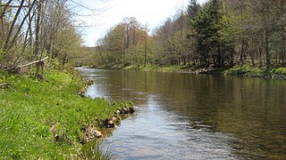
Tenmile Creek [1] is a 15.0-mile-long (24.1 km) [2] tributary of Catskill Creek in Albany County, New York. Via Catskill Creek, it is part of the Hudson River watershed.

Catskill Creek river in the United States of America

Catskill Creek is a 46.0-mile-long (74.0 km) tributary of the Hudson River that drains the northeastern Catskill Mountains of the U.S. State of New York. From its source at Franklinton Vlaie in Schoharie County it flows southeast through parts of Albany County and Greene County to its mouth at the village of Catskill on the Hudson River.

Albany County, New York county in New York, United States

Albany County is a county in the state of New York, in the United States. Its northern border is formed by the Mohawk River, at its confluence with the Hudson River, which is on the east. As of the 2010 census, the population was 304,204. The county seat is Albany, the state capital of New York. As originally established by the English government in the colonial era, Albany County had an indefinite amount of land, but has had an area of 530 square miles (1,400 km2) since March 3, 1888. The county is named for the Duke of York and of Albany, who became James II of England.

Hudson River river in New York State, draining into the Atlantic at New York City

The Hudson River is a 315-mile (507 km) river that flows from north to south primarily through eastern New York in the United States. The river originates in the Adirondack Mountains of Upstate New York, flows southward through the Hudson Valley to the Upper New York Bay between New York City and Jersey City. It eventually drains into the Atlantic Ocean at New York Harbor. The river serves as a political boundary between the states of New Jersey and New York at its southern end. Further north, it marks local boundaries between several New York counties. The lower half of the river is a tidal estuary, deeper than the body of water into which it flows, occupying the Hudson Fjord, an inlet which formed during the most recent period of North American glaciation, estimated at 26,000 to 13,300 years ago. Tidal waters influence the Hudson's flow from as far north as the city of Troy.

Contents

Tenmile Creek runs through the villages of Rensselaerville and Medusa in the town of Rensselaerville. It approaches the village through a deep ravine, falling 200 feet (61 m) in the course of 0.6 miles (1.0 km), which afforded great hydraulic power to early settlers. [3] The mill house in Medusa stood until the 1980s, when it was destroyed by fire.

Medusa, New York Hamlet in New York, United States

Medusa is a hamlet in the Town of Rensselaerville, in Albany County, New York, United States. The population was 376 at the 2000 census, which listed the community as a census-designated place (CDP), but it was not included as a CDP in the 2010 census.

Rensselaerville, New York Town in New York, United States

Rensselaerville is a town in Albany County, New York, United States. The population was 1,843 at the 2010 census. The town is named after Stephen Van Rensselaer. The "official" hamlets are Cooksburg, Medusa, Potter Hollow, Preston Hollow, and Rensselaerville.

Hydropower energy derived from falling or running water

Hydropower or water power is power derived from the energy of falling water or fast running water, which may be harnessed for useful purposes. Since ancient times, hydropower from many kinds of watermills has been used as a renewable energy source for irrigation and the operation of various mechanical devices, such as gristmills, sawmills, textile mills, trip hammers, dock cranes, domestic lifts, and ore mills. A trompe, which produces compressed air from falling water, is sometimes used to power other machinery at a distance.

Tributaries

See also

Related Research Articles

Mohawk River river in New York state, United States

The Mohawk River is a 149-mile-long (240 km) river in the U.S. state of New York. It is the largest tributary of the Hudson River. The Mohawk flows into the Hudson in Cohoes, New York, a few miles north of the city of Albany. The river is named for the Mohawk Nation of the Iroquois Confederacy. It is a major waterway in north-central New York.

Chenango River river in the United States of America

The Chenango River is a 90-mile-long (140 km) tributary of the Susquehanna River in central New York in the United States. It drains a dissected plateau area in upstate New York at the northern end of the Susquehanna watershed.

Ottawa River (Lake Erie) river in Ohio and Michigan, United States

The Ottawa River, also known as Ottawa Creek, is a short river, approximately 20 miles (32 km) long, in northwest Ohio and southeast Michigan in the United States. It drains an area on the Ohio-Michigan border along the eastern and northern fringes of the city of Toledo, goes through Ottawa Hills, and empties directly into Lake Erie. It is one of two rivers in northwestern Ohio that share the same name, along with the Ottawa River that is a tributary of the Auglaize River. The upper 4 miles (6 km) of the river in Michigan north of Sylvania, Ohio is called North Tenmile Creek on federal maps, while another branch rising in Fulton County, Ohio, is called Tenmile Creek.

Stony Clove Creek river in the United States of America

Stony Clove Creek is a 10.3-mile-long (16.6 km) creek in the Catskill Mountains in New York. It is a tributary of Esopus Creek, which in turn is a tributary of the Hudson River. It joins the Esopus in the village of Phoenicia, and has two smaller tributaries up north of Phoenicia.

Ontonagon River river in Michigan

The Ontonagon River is a river flowing to Lake Superior on the western Upper Peninsula of Michigan in the United States. The main stem of the river is 25 miles (40 km) long and is formed by a confluence of several longer branches, portions of which have been collectively designated as a National Wild and Scenic River. Several waterfalls occur on the river including Agate Falls and Bond Falls.

Ten Mile River (Housatonic River tributary)

The Ten Mile River is a 15.4-mile-long (24.8 km) river that flows through Dutchess County, New York, into westernmost Connecticut. The river is formed in the town of Amenia, New York, at the confluence of Webatuck Creek and Wassaic Creek. The Ten Mile River runs south through the town of Dover, New York before turning east and crossing into Connecticut, where it forms the boundary between the towns of Kent and Sherman for one-half mile before flowing into the Housatonic River. This is a popular whitewater paddling destination with mostly quickwater and a few whitewater areas reaching up to Class III.

Peekamoose Mountain mountain in United States of America

Peekamoose Mountain is a mountain located in Ulster County, New York. The mountain is part of the Catskill Mountains. Peekamoose Mountain is flanked to the north by Table Mountain. The name Peekamoose is possibly a corruption of an Algonquin word meaning 'broken off smooth', cf. Poke-O-Moonshine Mountain.

The West Branch Tenmile River is a 5.0-mile-long (8.0 km) tributary of the Tenmile River in western Maine. It is part of the Saco River watershed, flowing to the Atlantic Ocean.

Willowemoc Creek tributary of Beaver Kill

Willowemoc Creek is a tributary of Beaver Kill. It is a popular trout fishing stream near the Catskill Park in Sullivan County, New York.

Eightmile Creek is an 11.8-mile-long (19.0 km) tributary of Tenmile Creek in Albany County, New York. Via Tenmile Creek and Catskill Creek, it is part of the Hudson River watershed. Eightmile Creek runs through the town of Westerlo into the town of Rensselaerville, where it joins Tenmile Creek at the hamlet of Medusa. The creek's source is near Onderdonk Lake by Snyders Corners in Westerlo.

Lake Creek is a 5.8-mile-long (9.3 km) tributary of Catskill Creek in Albany and Schoharie counties, New York, in the United States. Via Catskill Creek, it is part of the Hudson River watershed. Lake Creek runs from the Rensselaerville State Forest in the town of Rensselaerville to Catskill Creek at Livingstonville in the town of Broome.

Fox Creek is a 6.0-mile-long (9.7 km) tributary of Catskill Creek in Albany County, New York. Via Catskill Creek, it is part of the Hudson River watershed. Fox Creek runs from the Rensselaerville State Forest in the town of Rensselaerville to Catskill Creek at Preston Hollow.

Bowery Creek is a 6.0-mile-long (9.7 km) tributary of Catskill Creek north of the Catskill Mountains of New York. Via Catskill Creek, it is part of the Hudson River watershed. Bowery Creek rises east of Windham High Peak in the northern part of the town of Cairo and flows northeast to Catskill Creek west of Freehold.

Jan de Bakker's Kill is a 7.1-mile-long (11.4 km) tributary of Catskill Creek, part of the Hudson River watershed, in the Catskill Mountains of New York.

Potic Creek is a 10.1-mile-long (16.3 km) tributary to Catskill Creek in the Catskill Mountains of New York. The name comes from the Dutch for a "water fall", originally referring to the falls in the Cats Kill near Wolcott Mills. Potic also originally referred to the name of the American Indian village below the falls and also of the commanding hill north of the falls.

Kaaterskill Creek is a 25.9-mile-long (41.7 km) tributary of Catskill Creek in Greene and Ulster counties in New York. Via Catskill Creek, it is part of the Hudson River watershed.

Vloman Kill river in the United States of America

The Vloman Kill is an 18.5-mile-long (29.8 km) tributary to the Hudson River in Albany County, New York, in the United States. Its source is in the town of New Scotland near the village of Voorheesville, and its mouth is at the Hudson River near the hamlet of Cedar Hill, in the town of Bethlehem.

Tenmile Creek (Coos County, Oregon)

Tenmile Creek is the outlet for a chain of lakes ending at Tenmile Lake near Lakeside in Coos County in the U.S. state of Oregon. The creek flows generally west for about 3 miles (5 km) from the lake to the Pacific Ocean. The stream's name stems from its approximate distance from Winchester Bay, the earliest pioneer village along this part of the coast.

References

  1. U.S. Geological Survey Geographic Names Information System: Tenmile Creek (Catskill Creek tributary)
  2. U.S. Geological Survey. National Hydrography Dataset high-resolution flowline data. The National Map, accessed October 3, 2011
  3. Albany Hill Towns Wiki, Albany Hill Towns Wiki. Accessed June 30, 2010.