Tufanganj II (community development block)

Last updated
Tufanganj-II
Community development block
India West Bengal adm location map.svg
Red pog.svg
Tufanganj-II
Location in West Bengal, India
Coordinates: 26°24′27″N89°51′41″E / 26.4073994°N 89.8612976°E / 26.4073994; 89.8612976 Coordinates: 26°24′27″N89°51′41″E / 26.4073994°N 89.8612976°E / 26.4073994; 89.8612976
CountryFlag of India.svg  India
State West Bengal
District Cooch Behar
Area
  Total257.08 km2 (99.26 sq mi)
Population
 (2001)
  Total167,428
  Density650/km2 (1,700/sq mi)
Languages
  OfficialRajbanshi(Bengali), Bengali, English
Time zone UTC+5:30 (IST)
Lok Sabha constituency Alipurduars
Vidhan Sabha constituency Tufanganj
Website coochbehar.gov.in

Tufanganj-II is a Community development block in Tufanganj subdivision of Cooch Behar district in the Indian state of West Bengal. It is headed by the Block Development Officer. Boxirhat police station serves this block. [1] [2]

Tufanganj subdivision is a subdivision of the Cooch Behar district in the state of West Bengal, India. It consists of Tufanganj municipality and two community development blocks: Tufanganj–I and Tufanganj–II. The two blocks contain 25 gram panchayats. The subdivision has its headquarters at Tufanganj.

Cooch Behar district District of West Bengal in India

Cooch Behar district is a district of the state of West Bengal, India, as well as the district's namesake town. During the British Raj, the town of Cooch Behar was the seat of a princely state of Koch Bihar, ruled by the Koch dynasty.

India Country in South Asia

India is a country in South Asia. It is the seventh-largest country by area, the second-most populous country, and the most populous democracy in the world. Bounded by the Indian Ocean on the south, the Arabian Sea on the southwest, and the Bay of Bengal on the southeast, it shares land borders with Pakistan to the west; China, Nepal, and Bhutan to the north; and Bangladesh and Myanmar to the east. In the Indian Ocean, India is in the vicinity of Sri Lanka and the Maldives; its Andaman and Nicobar Islands share a maritime border with Thailand and Indonesia.

Contents

Geography


Tufanganj-II community development block has an area of 257.08  km2.All the area of this block are Rural Area in characteristics. [2]

Gram panchayats

There are 11 Gram Panchayats under Tufanganj-II Development Block/Panchayat Samity. Gram panchayats of Tufanganj II block/ Panchayat samity are: Barokodali I, Barokodali II, Bhanukumari I, Bhanukumar II, Falimari, Mahiskuchi I, Mahiskuchi II, Rampur I, Rampur II, Salbari I and Salbari II.

A gram panchayat or village panchayat is the only grassroots-level of panchayati raj formalised local self-governance system in India at the village or small-town level, and has a sarpanch as its elected head.

[3] Falimari, a constituent panchayat of the block, is located at 26°24′27″N89°51′41″E / 26.4073994°N 89.8612976°E / 26.4073994; 89.8612976 .

Demographics

As per 2011 Census of India Tufanganj II CD Block had a total population of 186726, of which 181,246 were rural and 5,480 were urban. There were 96,222 males and 90,504 females. Scheduled Castes numbered 100,378 and Scheduled Tribes numbered 3,966. [4]

2011 Census of India 15th Indian Census

The 15th Indian Census was conducted in two phases, house listing and population enumeration. House listing phase began on 1 April 2010 and involved collection of information about all buildings. Information for National Population Register (NPR) was also collected in the first phase, which will be used to issue a 12-digit unique identification number to all registered Indian residents by Unique Identification Authority of India (UIDAI). The second population enumeration phase was conducted between 9 and 28 February 2011. Census has been conducted in India since 1872 and 2011 marks the first time biometric information was collected. According to the provisional reports released on 31 March 2011, the Indian population increased to 1.21 billion with a decadal growth of 17.70%. Adult literacy rate increased to 74.04% with a decadal growth of 9.21%. The motto of the census was 'Our Census, Our future'.

Scheduled Castes and Scheduled Tribes official designations given to various groups indigenous people in India

The Scheduled Castes (SCs) and Scheduled Tribes (STs) are officially designated groups of historically disadvantaged people in India. The terms are recognised in the Constitution of India and the groups are designated in one or other of the categories. For much of the period of British rule in the Indian subcontinent, they were known as the Depressed Classes.

Literacy

As per 2011 census the total number of literates in Tufanganj II CD Block was 125,207 out of which 70,041 were males and 55,166 were females. [4]

Related Research Articles

Cooch Behar Sadar subdivision subdivision in West Bengal, India

Cooch Behar Sadar subdivision is a subdivision of the Cooch Behar district in the state of West Bengal, India. It consists of Cooch Behar municipality and two community development blocs: Cooch Behar–I and Cooch Behar–II. The two blocks contain 28 gram panchayats and three census towns. The subdivision has its headquarters at Cooch Behar.

Mathabhanga subdivision subdivision in West Bengal, India

Mathabhanga subdivision is a subdivision of the Cooch Behar district in the state of West Bengal, India. It consists of Mathabhanga municipality and three community development blocks: Sitalkuchi, Mathabhanga–I and Mathabhanga–II. The three blocks contain 28 gram panchayats. The subdivision has its headquarters at Mathabhanga.

Natabari Vidhan Sabha constituency in West Bengal, India

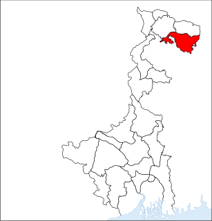
Natabari is an assembly constituency in Cooch Behar district in the Indian state of West Bengal.

Dhupguri (community development block) Community development block in West Bengal, India

Dhupguri is an administrative division in Jalpaiguri Sadar subdivision of Jalpaiguri district in the Indian state of West Bengal. Dhupguri and Banarhat police stations serve this block. Headquarters of this block is at Dhupguri. Municipalities include Dhupguri while the census towns in this block are: Banarhat and Binnaguri.

Alipurduar I Community development block in West Bengal, India

Alipurduar I is an administrative division in Alipurduar subdivision of Alipurduar district in the Indian state of West Bengal. Alipurduar police station serves this block. Headquarters of this block is at Panchkalguri. There are four census towns in this block: Paschim Jitpur, Chechakhata, Alipurduar Railway Junction and Bholar Dabri.

Alipurduar II Community development block in West Bengal, India

Alipurduar II is an administrative division in Alipurduar subdivision of Alipurduar district in the Indian state of West Bengal. Alipurduar police station serves this block. Headquarters of this block is at Josodanga. There is one census towns in this block: Sobhaganj.

Falakata (community development block) Community development block in West Bengal, India

Falakata is an administrative division in Alipurduar subdivision of Alipurduar district in the Indian state of West Bengal. Falakata police station serves this block. Headquarters of this block is at Falakata. There is one census town in this block: Falakata.

Kumargram Community development block in West Bengal, India

Kumargram is an administrative division in Alipurduar subdivision of Alipurduar district in the Indian state of West Bengal. Kumargram police station serves this block. Headquarters of this block is at Kumargram. There is one census town in this block: Uttar Kamakhyaguri.

Cooch Behar I Community development block in West Bengal, India

Cooch Behar I is an administrative division in Cooch Behar Sadar subdivision of Cooch Behar district in the Indian state of West Bengal. Koch Bihar police station serves this block. Headquarters of this block is at Dhaluabari, Ghugumari. There are two census towns in this block: Kharimala Khagrabari and Guriahati.

Cooch Behar II Community development block in West Bengal, India

Cooch Behar II is an administrative division in Cooch Behar Sadar subdivision of Cooch Behar district in the Indian state of West Bengal. Koch Bihar police station serves this block. Headquarters of this block is at Pundibari. There is one census town in this block: Khagrabari.

Dinhata I Community development block in West Bengal, India

Dinhata I is an administrative division in Dinhata subdivision of Cooch Behar district in the Indian state of West Bengal. Dinhata police station serves this block. Headquarters of this block is at Dinhata. There is one census town in this block: Bhangri Pratham Khanda.

Dinhata II Community development block in West Bengal, India

Dinhata II is an administrative division in Dinhata subdivision of Cooch Behar district in the Indian state of West Bengal. Dinhata police station serves this block. Headquarters of this block is at Sahebganj.

Sitai Community development block in West Bengal, India

Sitai is an administrative division in Dinhata subdivision of Cooch Behar district in the Indian state of West Bengal. Sitai police station serves this block. Headquarters of this block is at Sitai.

Sitalkuchi Community development block in West Bengal, India

Sitalkuchi is an administrative division in Mathabhanga subdivision of Cooch Behar district in the Indian state of West Bengal. Sitalkuchi police station serves this block. Headquarters of this block is at Sitalkuchi.

Mathabhanga I Community development block in West Bengal, India

Mathabhanga I is an administrative division in Mathabhanga subdivision of Cooch Behar district in the Indian state of West Bengal. Mathabhanga and Ghoksadanga police stations serve this block. Headquarters of this block is at Mathabhanga.

Mathabhanga II Community development block in West Bengal, India

Mathabhanga II is an administrative division in Mathabhanga subdivision of Cooch Behar district in the Indian state of West Bengal. Mathabhanga and Ghoksadanga police stations serve this block. Headquarters of this block is at Bhogmara.

Mekhliganj (community development block) Community development block in West Bengal, India

Mekhliganj is an administrative division in Mekhliganj subdivision of Cooch Behar district in the Indian state of West Bengal. Mekhliganj and Kuchlibari police stations serve this block. Headquarters of this block is at Changrabandha.

Haldibari (community development block) Community development block in West Bengal, India

Haldibari is an administrative division in Mekhliganj subdivision of Cooch Behar district in the Indian state of West Bengal. Haldibari police station serves this block. Headquarters of this block is at Haldibari.

Tufanganj I (community development block) Community development block in West Bengal, India

Tufanganj I is an administrative division in Tufanganj subdivision of Cooch Behar district in the Indian state of West Bengal. Tufanganj police station serves this block. Headquarters of this block is at Tufanganj.

References

  1. "Contact details of Block Development Officers". Cooch Behar district. West Bengal Government. Retrieved 2011-03-20.
  2. 1 2 "Census of India 2001, Provisional Population Totals, West Bengal, Table - 4". Cooch Behar District (03). Government of West Bengal. Archived from the original on September 27, 2007. Retrieved 2012-04-12.CS1 maint: unfit url (link)
  3. "Relation between Blocks & Gram Panchayats (GPs)". Cooch Behar District Administration. Retrieved 2011-03-20.
  4. 1 2 "C.D. Block Wise Primary Census Abstract Data(PCA)". West Bengal – District-wise CD Blocks. Registrar General and Census Commissioner, India. Retrieved 10 August 2015.