Dhuliyan | |
|---|---|
Town | |
| Coordinates: 24°40′52″N87°57′14″E / 24.681°N 87.954°E Coordinates: 24°40′52″N87°57′14″E / 24.681°N 87.954°E | |
| Country | |
| State | West Bengal |
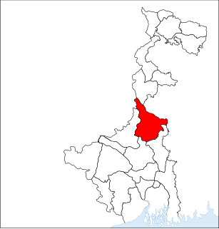
| District | Murshidabad |
| Government | |
| • Type | Municipality |
| • Body | Dhuliyan Municipality |
| Elevation | 4 m (13 ft) |
| Languages | |
| • Official | Bengali, English |
| Time zone | UTC+5:30 (IST) |
| PIN | 742202 |
| Telephone code | +91-3485 |
| Vehicle registration | WB58, WB94 |
| Lok Sabha constituency | Maldaha Dakshin |
| Vidhan Sabha constituency | Samserganj |
| Website | www.dhuliyanmunicipality.in |
Dhuliyan is a municipality town in Jangipur subdivision of Murshidabad district in the state of West Bengal, India. It is located between the Ganges and the Hooghly canal.
Jangipur subdivision is an administrative subdivision of Murshidabad district in the state of West Bengal, India.
Murshidabad district is a district of in the Indian state of West Bengal. Situated on the left bank of the river Ganges, the district is very fertile. Covering an area of 5,341 km² and having a population 7.103 million ,it is a densely populated district and the ninth most populous in India. Baharampur town is the headquarters of the district.
West Bengal is a state in the eastern region of India along the Bay of Bengal. With over 91 million inhabitants, it is India's fourth-most populous state. West Bengal is the thirteenth-largest Indian state, with an area of 88,752 km2 (34,267 sq mi). Part of the ethno-linguistic Bengal region of the Indian subcontinent, it borders Bangladesh in the east, and Nepal and Bhutan in the north. It also borders the Indian states of Odisha, Jharkhand, Bihar, Sikkim, and Assam. The state capital is Kolkata (Calcutta) the seventh-largest city in India, and center of the third-largest metropolitan area in the country. West Bengal includes the Darjeeling Himalayan hill region, the Ganges delta, the Rarh region, and the coastal Sundarbans. The main ethnic group is the Bengalis, with Bengali Hindus forming the demographic majority.
Dhuliyan has been mentioned as an inland water transport (IWT) trading point between Murshidabad and the city of Rajshahi in Bangladesh. Low-cost barges could ply the Ganges river, called Padma in downstream Bangladesh, exchanging goods and reducing smuggling. This proposal has not been agreed to yet by the two countries.
Rajshahi is a metropolitan city, and a major urban, commercial and educational centre of Bangladesh. It is also the administrative seat of eponymous division and district. Located on the north bank of the Padma River, near the Bangladesh-India border, the city has a population of over 763,952 residents. The city is surrounded by the satellite towns of Nowhata and Katakhali, which together build an urban agglomeration of about 1 million population. Arguably Rajshahi is the most clean and green among cities in Bangladesh.
Bangladesh, officially the People's Republic of Bangladesh, is a country in South Asia. While the country is the 92nd-largest in land area, spanning 147,570 square kilometres (56,980 sq mi), it is the world's 8th-most populous with nearly 163 million people, making it one of the most densely populated countries in the world. Bangladesh shares land borders with India to the west, north, and east, Myanmar to the southeast, and the Bay of Bengal to the south. Dhaka, the capital and largest city, is the nation's economic, political and cultural hub. Chittagong, the largest sea port, is the second largest city. The dominant geographic feature is the Ganges delta, which empties into the Bay of Bengal the combined waters of several river systems, including the Brahmaputra and the Ganges, with numerous criss-crossing rivers and inland waterways. Highlands with evergreen forests cover the northeastern and southeastern regions. The seacoast features the longest natural sea beach and most of the world's largest mangrove forest. The country's biodiversity includes a vast array of plants and wildlife, including the endangered Bengal tiger, the national animal.
The Ganges, or Ganga, is a trans-boundary river of Asia which flows through India and Bangladesh. The 2,525 km (1,569 mi) river rises in the western Himalayas in the Indian state of Uttarakhand, and flows south and east through the Gangetic Plain of India and Bangladesh, eventually emptying into the Bay of Bengal.
Dhuliyan is located at 24°40′52″N87°57′14″E / 24.681°N 87.954°E . [1] It has an average elevation of 4 metres (13 feet).
Dhuliyan is surrounded by Farakka (to the north), Aurangabad (to the South) Pakur (to the West) and Ganges River (Ganga) (to the East).
Farakka is a town, with a police station and a post office, not identified in 2011 census, in Farakka community development block in the Jangipur subdivision of the Murshidabad district in the state of West Bengal, India.
Dhuliyan includes Dhuliyan Bazar, Jafrabad, Tinpakuria, Kankuria, House Nagar, Anup Nagar & Dakbanglow area.
In the 2011 census, Dhulian Urban Agglomeration had a population of 239,022, out of which 119,151 were males and 119,871 were females. The 0–6 years population was 45,483. Effective literacy rate for the 7+ population was 60.06 per cent. [2]
As of 2001 [update] India census, [3] Dhulian had a population of 72,906. Males constitute 50% of the population and females 50%. Dhulian has an average literacy rate of 39%, lower than the national average of 59.5%: male literacy is 48% and, female literacy is 31%. In Dhulian, 20% of the population is under 6 years of age.
Samserganj police station, located in Dhulian, has jurisdiction over Samserganj CD Block. [4]
The headquarters of Samserganj CD Block are located at Dhulian. [5]
National Highway 34 passes through Dhulian town. Dhulian Ganga railway station is situated in Malda railway division of Barharwa–Azimganj–Katwa loop line.
Nur Mohammad Smriti Mahavidyalaya was established in 2008 at Dhulian. It has Bengali, English, History, Sociology and Education departments. [6] [7]
Malda or English Bazar is a metropolitan city in the Indian state of West Bengal. It is the sixth largest city in West Bengal. It is the district headquarters of Malda district. Malda city consists of two municipalities - English Bazar Municipality and Old Malda Municipality, under English Bazar Metropolitan Area. This was an Undeveloped City which had been becoming bigger since 1925-1930. Now the city is rapidly growing and its population is inching towards half million.
Habra is a city and a municipality under Barasat sadar subdivision in North 24 Parganas district of the Indian state of West Bengal. Habra is situated on the Jessore Road between Kolkata and the Bangladesh border at Petrapole. Its location makes it an important town for export and import of goods between India and Bangladesh.
Berhampore is a city and a municipality in the state of West Bengal, India. As of the 2011 census, it had a population of 305,609 and was the seventh largest city in West Bengal. It used to be known as Brahmapur because many of the Brahmin families settled here. Berhampore is the administrative headquarters of the Murshidabad district. It is located about 200 km (124 mi) from Kolkata, the state capital.
Memari is a town and a municipality in Purba Bardhaman district in the Indian state of West Bengal.
Kankuria is a census town in Samserganj CD Block, under Dhulian Circle Area in Jangipur subdivision of Murshidabad district in the Indian state of West Bengal.
Al-Ameen Mission is a residential institute located in a village Khalatpur in Howrah district of West Bengal, India. Established in 1986 it is now spread across 17 districts of the state with 58 branches and spread in other states like Assam, Tripura, Jharkhand. It has 12 thousand residential students now. Here passed about 20 thousands students.It has started its journey through CBSE curriculum also. Very recently Al Ameen Mission has started some branches which are following the CBSE.
Kharar is a city and a municipality in Paschim Medinipur district in the Indian state of West Bengal.
Aurangabad is a town in Suti II CD Block in Jangipur subdivision of Murshidabad district in the Indian state of West Bengal.
Domkal subdivision is an administrative subdivision of Murshidabad district in the state of West Bengal, India.
Kandi subdivision is an administrative subdivision of Murshidabad district in the state of West Bengal, India.
Bhagawangola I is a community development block that forms an administrative division in Lalbag subdivision of Murshidabad district in the Indian state of West Bengal.
Jalangi is a village, with a police station, not identified in 2011 census, in Jalangi CD Block in Domkol subdivision of Murshidabad district in the state of West Bengal, India. This village is situated beside the Padma River
Raninagar I is a community development block that forms an administrative division in Domkol subdivision of Murshidabad district in the Indian state of West Bengal.
Samserganj is a community development block that forms an administrative division in Jangipur subdivision of Murshidabad district in the Indian state of West Bengal.
Islampur is a census town in Raninagar I CD Block in Domkol subdivision of Murshidabad district in the state of West Bengal, India.
River bank erosion along the Ganges in Malda and Murshidabad districts focusses on river bank erosion along the main channel of the Ganges in Malda and Mushidabad districts of West Bengal, India.
Amtala is a town, with a college, not identified in 2011 census, in Naoda CD Block in Barhampur subdivision of Murshidabad district in the state of West Bengal, India.
Gazole is a village in Gazole CD Block in Malda Sadar subdivision of Malda district in the Indian state of West Bengal. Gazole police station serves this town. The headquarters of Gazole block is Gazole.
| This article about a location in West Bengal is a stub. You can help Wikipedia by expanding it. |